|
4. COMPREHENSIVE ZONING BY-LAW
2008-250: ANOMALIES AND MINOR CORRECTIONS - FIFTH REPORT RÈGLEMENT DE ZONAGE 2008-250 : ANOMALIES ET
CORRECTIONS MINEURES – CINQUIÈME RAPPORT |
Agriculture and Rural Affairs
Committee recommendation
That Council approve the amendments
recommended in Column 4 of Document 2, to correct anomalies in Zoning By-law
2008-250.
Planning and environment
Committee recommendation as amended
(This
application is subject to Bill 51)
That Council approve the amendments
recommended in Column 4 of Document 1, to correct anomalies in Zoning By-law
2008-250, as amended in Item 9, Column 4 to indicate a minimum lot area of
“3250 square metres” instead of “3504 square metres”.
Recommandation DU ComitÉ de l’agriculture et des questions rurales
Que le Conseil approuve les modifications recommandées dans la Colonne 4
du Document 2 afin de corriger des anomalies dans le Règlement de zonage
2008-250.
Recommandation MODIFIÉE DU Comité de l’urbanisme
et de l’environnement
(Cette demande
est assujettie au Règlement 51)
Que le Conseil approuve les
modifications recommandées dans la colonne 4 du document 1 afin de
corriger des anomalies dans le Règlement de zonage no 2008-250,
comme elles ont été modifiées à la colonne 4 du point 9, afin d’indiquer
une superficie de lot minimale de « 3 250 mètres carrés »
au lieu de « 3 504 mètres carrés ».
Documentation
1.
Deputy
City Manager’s report, Infrastructure Services and Community Sustainability
dated 6 April 2009 (ACS2009-ICS-PLA-0066).
2. Extract
of Draft Minute, 28 April 2009.
Report to/Rapport au :
Agricultural
and Rural Affairs Committee
Comité de l'agriculture et des questions rurales
and/et
Planning and Environment
Committee
Comité de l'urbanisme et de l'environnement
and Council / et au Conseil
April 6, 2009 / le 6 avril 2009
Submitted
by/Soumis par : Nancy Schepers, Deputy City
Manager/Directrice municipale adjointe,
Infrastructure Services and Community Sustainability/Services
d'infrastructure et Viabilité des collectivités
Contact Person/Personne-ressource : Richard
Kilstrom, Manager/Gestionnaire, Policy Development and Urban Design/Élaboration
de la politique et conception urbaine, Planning and Growth Management/Urbanisme
et Gestion de la croissance Élaboration de la politique et conception urbaine
(613) 580-2424
x22653, Richard.Kilstrom@ottawa.ca
SUBJECT:
|
COMPREHENSIVE
ZONING BY-LAW 2008-250: ANOMALIES AND MINOR CORRECTIONS - FiftH REPORT |
|
|
|
OBJET :
|
RÈGLEMENT DE ZONAGE 2008-250 : ANOMALIES ET CORRECTIONS
MINEURES – cinquiÈme RAPPORT |
REPORT
RECOMMENDATIONS
1. That Planning and Environment Committee recommend that
Council approve the amendments recommended in Column 4 of Document 1, to
correct anomalies in Zoning By-law 2008-250; and
2. That Agriculture and Rural Affairs Committee recommend that
Council approve the amendments recommended in Column 4 of Document 2, to
correct anomalies in Zoning By-law 2008-250.
RECOMMANDATIONS DU RAPPORT
1. Que le Comité de
l’urbanisme et de l’environnement recommande au Conseil d’approuver les
modifications recommandées dans la Colonne 4 du Document 1 afin de corriger des
anomalies dans le Règlement de zonage 2008-250;
2. Que le Comité de
l’agriculture et des affaires rurales recommande au Conseil d’approuver les
modifications recommandées dans la Colonne 4 du Document 2 afin de corriger des
anomalies dans le Règlement de zonage 2008-250.
BACKGROUND
Anomalies
On June 25, 2008 City Council adopted the new Comprehensive Zoning By-law 2008-250 which affects all properties within Ottawa. By-law 2008-250 replaces the 36 Zoning By-laws of the former municipalities that were amalgamated in 2001. Since the adoption of the Zoning By-law, staff has been identifying anomalies that require correction, and reports to correct the anomalies are being forwarded to Committee and Council on a regular basis. This report details recommended amendments to correct a number of the identified anomalies.
DISCUSSION
Anomalies
Since the adoption of the Zoning By-law 2008-250, staff has monitored the new by-law and has identified certain anomalies that are being recommended for correction. Documents 1 and 2 provide staff recommendations to Planning and Environment Committee and Agriculture and Rural Affairs Committee on the anomalies, and include details of the recommended amendments in the urban area in Column 4 of Document 1, and amendments to the rural or greenbelt areas in Column 4 of Document 2. Document 3 contains the maps showing the location of zoning map corrections.
The amendments are intended to correct mapping and text reference errors in the implementation of Council-approved changes that were not accurately reflected in the Comprehensive Zoning By-law.
CONSULTATION
Notice of the public meeting to deal with these anomalies and corrections was provided in The Citizen and Le Droit, with a listing of the addresses and provisions subject to correction. As well, interested parties have been notified by individual mail.
LEGAL/RISK
MANAGEMENT IMPLICATIONS
The changes addressed this
report are items of a routine nature.
There are no Legal/Risk Management implications.
FINANCIAL
IMPLICATIONS
SUPPORTING DOCUMENTATION
Document 1 List of Anomalies and Modifications to Zoning By-law 2008-250 for consideration by Planning and Environment Committee
Document 2 List of Anomalies and Modifications to Zoning By-law 2008-250 for consideration by Agriculture and Rural Affairs Committee
Document 3 Location Maps
DISPOSITION
Planning and Growth Management Department to prepare the implementing by-law, forward it to Legal Services who will then forward the by-law to City Council.
|
Item
No. |
Reference |
Objective
of Amendment |
Proposed
Amendment |
|
The former site
specific MS2-X2 zone for these lands permitted a “fitness club establishment”
but not a “recreational establishment”. When this zone was brought forward
into the IG [1608] H(21)-h zone, the new use “recreational and athletic
facility” was not included, which use is intended to include fitness clubs. |
|||
|
A few words are
missing in the text and should be added to ensure clarity of intent. |
|||
|
The last exception provision should state "Section 188, subsection 14(b) does not apply" to correct a typographical error which occurred in the amending By-law 2009-18. An additional provision should also be added to reflect the former "C-4" zoning from the former Township of Goulbourn Zoning By-law 40-99: "-minimum front yard setback: 0 metres" |
|||
|
The wording of Exception [1219] applicable to these lands does not adequately implement the Official Plan secondary planning policies for the South Nepean Urban Area. Policy 2.2.5.1 states that, in Prestige Business Parks, “accessory and co-located retail service and entertainment facilities” may be developed in association with the standard permitted uses. This was intended to mean that that retail services and entertainment facilities should be permitted only within a larger complex containing research and development centres, technology industries, light industrial uses, offices,
banks, instructional facilities, hotels and places of assembly. Stand-alone
retail services and entertainment facilities were not intended to be
permitted. Exception [1219] should be amended to clarify this intent. |
Amend Exception
[1219] to add the following additional provision to Column V: |
||
|
The wording of this section unintentionally permits additions above the first floor of a building that is non-complying for yards. |
|||
|
1992 and 2000 Tenth Line Road and 4419 Innes Road Ward 19 |
|||
|
Table 55 (1)
indicates generally in which yards accessory uses, buildings or structures
are permitted and then (2) to (4) deals with setbacks for accessory
structures from various lot lines, making provision (1) redundant and
unclear. |
Amend Table 55 to
delete Row (1) Permitted Location, and to renumber subsequent rows |
||
|
Enforcement staff from the Emergency and Protective
Services Branch has requested a revision to the wording of this section to
allow for the application of set fines for illegal temporary car shelters. In
order to do this, the provision must be revised to include the words “No
person shall…use…” |
Except in the case of the MD zone, no person shall, where an accessory use is in a different building than the principal use to which it is accessory, use that accessory building: (a) for human habitation; and (b)
in non-compliance with the
provisions set out in Table 55. |
||
|
Item
No. |
Reference |
Objective
of Amendment |
Proposed
Amendment |
|
Column
III, Row 8(a) and (b) be deleted and replaced with: (a) in
an EP zone, if accessory to residential use, aggregate of all accessory
buildings not to exceed 55 m2 or if accessory to other uses, aggregate
of all accessory buildings not to exceed 150 m2 |
|||
|
Location Maps (attached) |
|
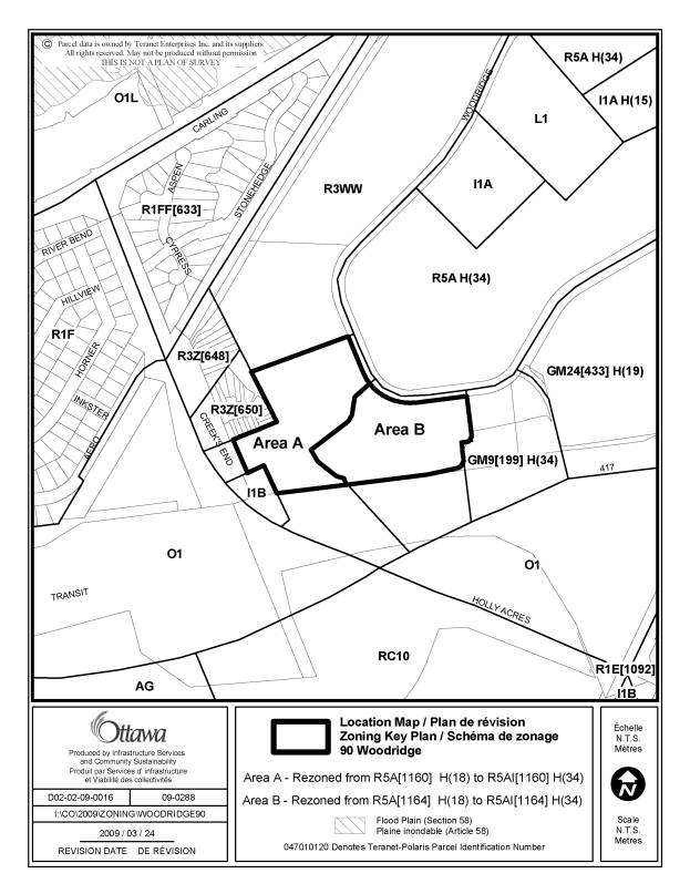
Part of 90 Woodridge Crescent |
|
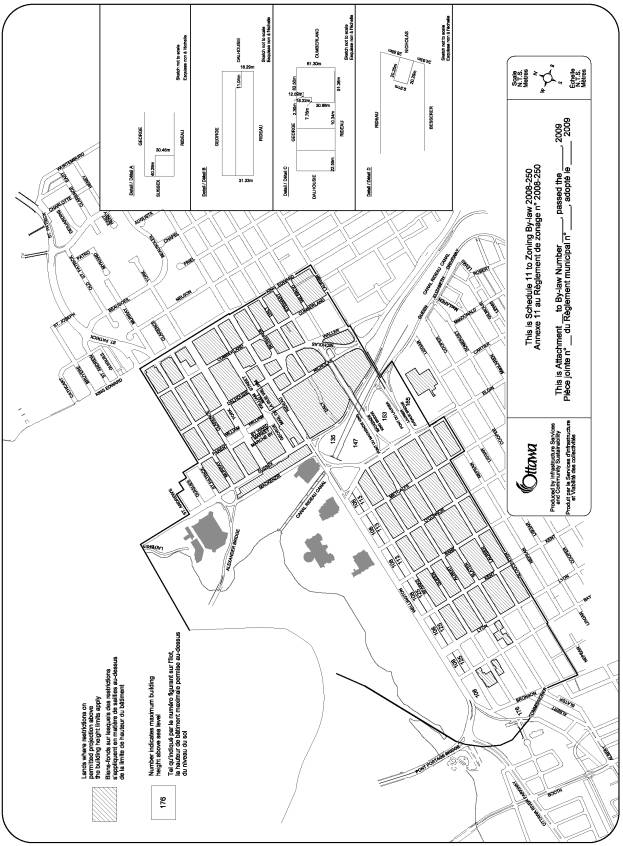
Schedule
11 – Central Area Height Schedules |
|
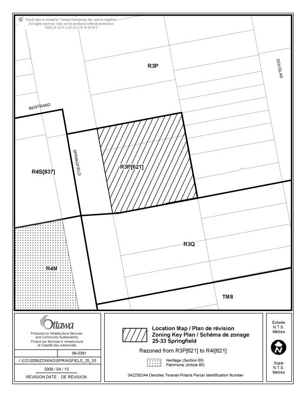
25-33 Springfield Road |
|
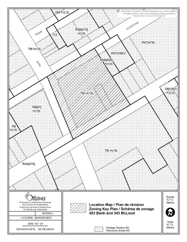
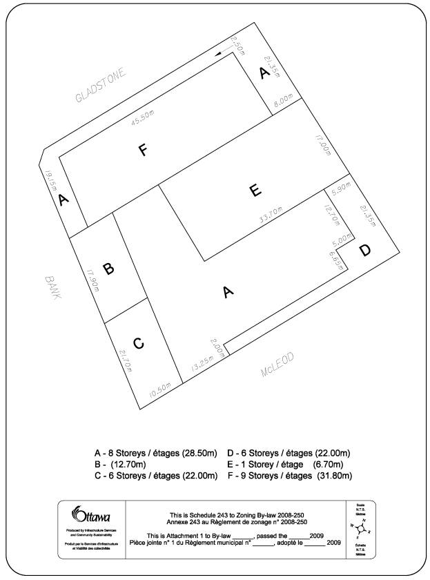
453 Bank Street and 343 McLeod Street |
|
Schedule
243 |
|
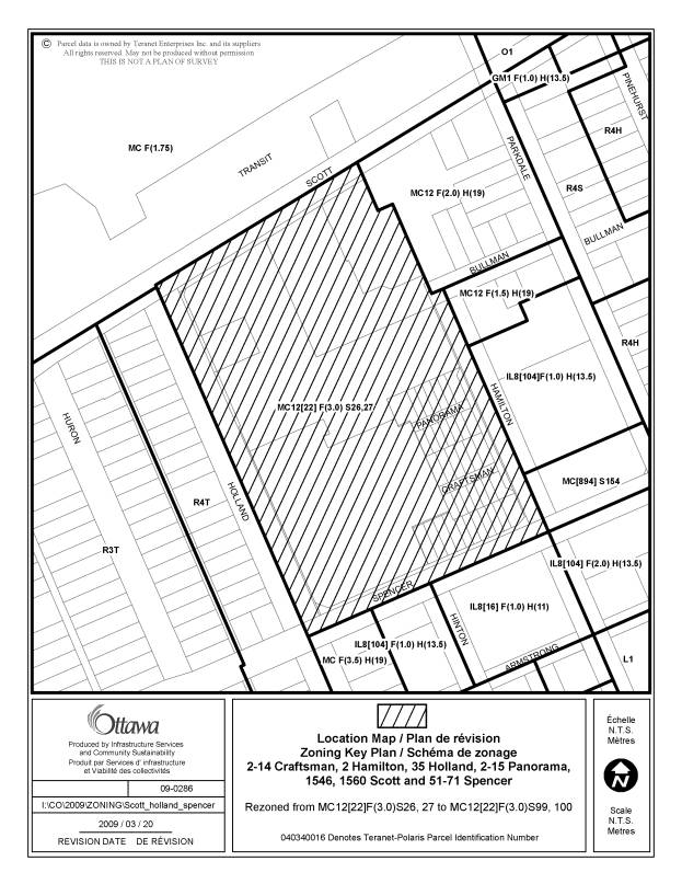
Scott,
Holland, Hamilton and Spencer |
|
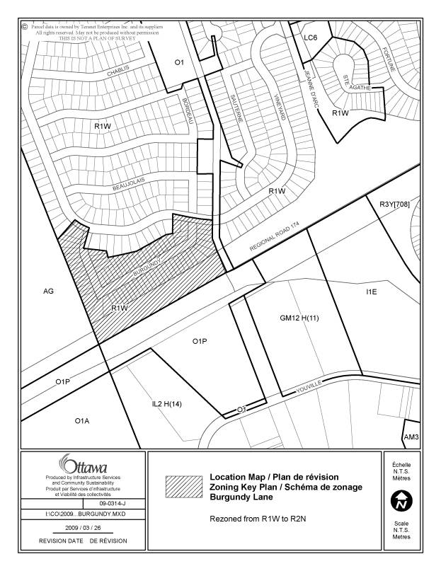
Burgundy Lane |
|
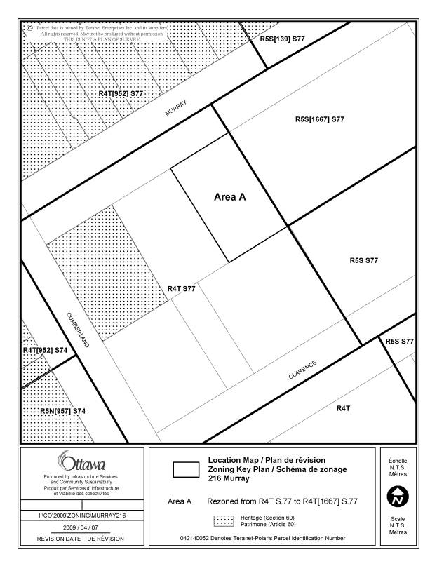
216 Murray Street |
|
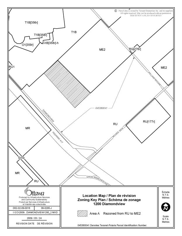
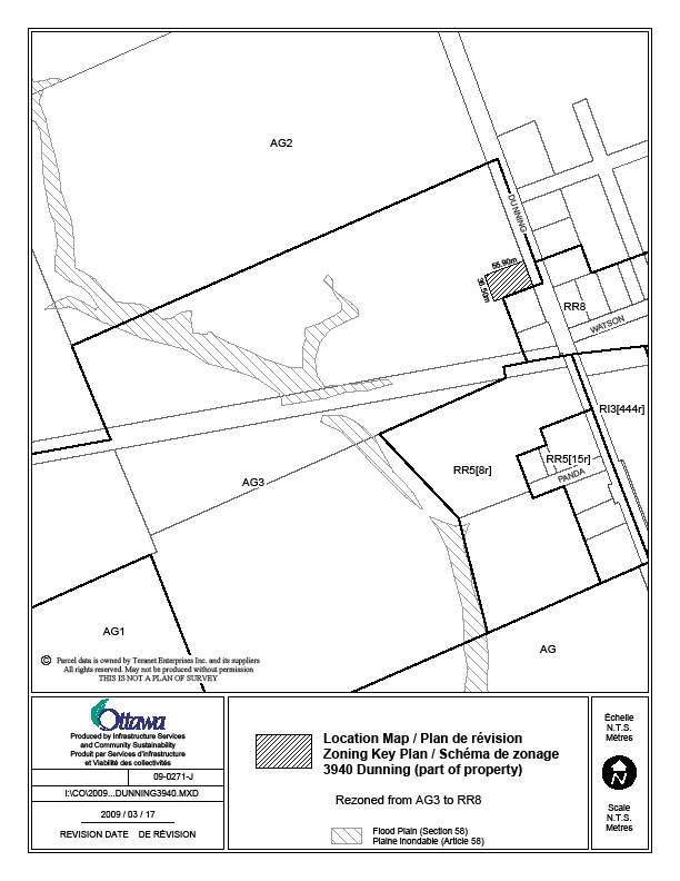
Part of 3940 Dunning Road |
|
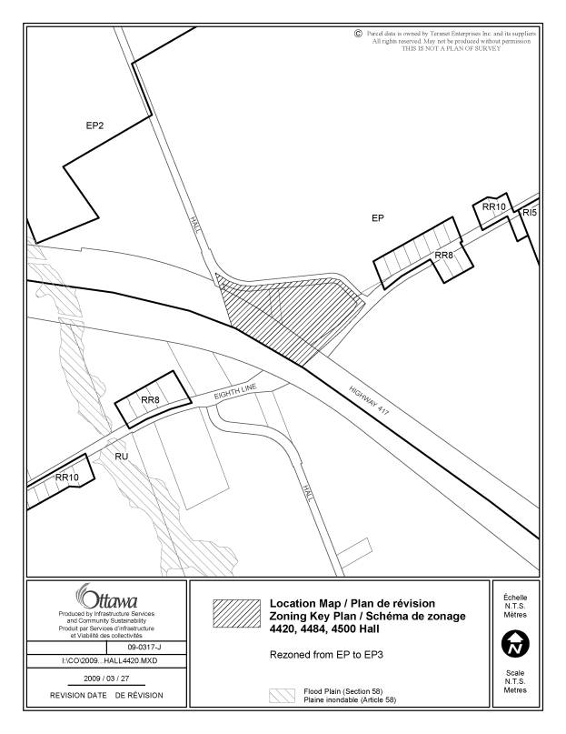
4420, 4484 and 4500 Hall Road |
|
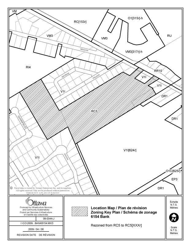
6154
Bank Street |
|
895
March Road |