|
1. COMPREHENSIVE ZONING
BY-LAW 2008-250: ANOMALIES AND MINOR CORRECTIONS- SIXTH REPORT RÈGLEMENT DE ZONAGE 2008-250 : ANOMALIES ET CORRECTIONS MINEURES –
SIXIÈME RAPPORT |
Agriculture
and Rural Affairs Committee Recommendation
(This matter is subject to Bill 51)
That Council approve the amendments
recommended in Column 3 of Document 2, to correct anomalies in Zoning By-law
2008-250.
PLANNING
AND ENVIRONMENT Committee Recommendations As amended
That
Council approve the amendments
recommended in Column 3 of Document 1, to correct anomalies in Zoning By-law
2008-250, as amended by the following:
·
That Item 2-Column 2 be amended by adding
the following as a new paragraph, after “…as per the OMB Order” and before
“This implements the Uptown Rideau Community Design Plan”:
“To fully implement the OMB Order by-law 2008-62 must
be correctly reflected in the zoning by-law.”
·
That Item 2–Column 3 be amended by adding
the following at the end:
“Further amend Part 15, Section 239 by amending
column V of exception 1603 by deleting the number 18.5 and replacing it with
the number 5.”
·
That Item 9 be added to Document 1 as
follows:
Column 1: 9. Grenwich
Circle – R1S subzone, Ward 16
Column 2: There is an error on the zoning map
for the R1 S subzone on Grenwich Circle. Exception 515 was created for these properties but it was not
applied on the zoning map.
Column 3: Amend
the zoning map by adding exception 515 to the R1S subzone for properties on
Grenwich Circle.
Recommandation du Comité de l'agriculture et
des questions rurales
(Cette
application est assujettie au Règlement 51)
Que le Conseil approuve les modifications recommandées dans la Colonne 4 du Document 2
afin de corriger des anomalies dans le Règlement de zonage 2008-250.
RecommandationS modifiÉeS du Comité de l’urbanisme et
de l’environnement
Que le Conseil approuve les modifications recommandées dans la Colonne 4
du Document 1 afin de corriger des anomalies dans le Règlement de zonage
2008-250, ainsi modifiées :
·
Que le point 2 – colonne 2 soit modifié
par l’ajout du nouveau paragraphe suivant, après « ...conformément à
l’ordre de la CAMO » et avant « Cela met en œuvre le plan de
conception communautaire du secteur Est de la rue Rideau » :
« Pour appliquer complètement l’ordre
de la CAMO, le règlement 2008-62 doit être adéquatement pris en compte dans le
règlement de zonage. »
·
Que le point 2 – colonne 3 soit modifié
par l’ajout de la mention suivante à la suite du texte :
« Modifier encore la partie 15, section 239, en
modifiant la colonne V de l’exception 1603, en supprimant le numéro 18.5 et en
le remplaçant par le numéro 5. »
·
Que le point 9 soit ajouté au Document 1,
de la manière suivante :
Colonne 1 : 9. Rond-point Grenwich – sous-zone R1S,
quartier 16
Colonne 2 : Erreur
sur la carte de zonage concernant la sous-zone R1 S au rond-point Grenwich.
L’exception 515 a été créée pour ces propriétés mais n’a pas été appliquée sur
la carte de zonage.
Colonne 3 : Modifier
la carte de zonage en ajoutant l’exception 515 à la sous-zone R1S pour les
propriétés située au rond-point Grenwich.
Documentation
1.
Deputy
City Manager's report Infrastructure Services and Community Sustainability
dated 13 May 2009 (ACS2009-ICS-PLA-0084).
2.
Planning
and Environment Committee, Extract of Draft Minutes 55, dated 26 May 2009.
Report to/Rapport au :
Planning and Environment Committee
Comité de l'urbanisme et de l'environnement
and / et
Agriculture and Rural Affairs Committee
Comité de l'agriculture et des questions rurales
and Council / et au Conseil
Submitted by/Soumis par : Nancy Schepers, Deputy City Manager
Directrice municipale adjointe,
Infrastructure Services and
Community Sustainability
Services d’infrastructure et
Viabilité des collectivités
Contact Person/Personne-ressource : Richard Kilstrom, Manager/Gestionnaire, Policy Development and Urban Design/Élaboration de la politique et conception urbaine,
Planning and Growth Management/Urbanisme et Gestion de la croissance
(613)
580-2424 x22653, Richard.Kilstrom@ottawa.ca
SUBJECT:
|
COMPREHENSIVE ZONING BY-LAW 2008-250:
ANOMALIES AND MINOR CORRECTIONS- SIXTH REPORT |
|
|
|
OBJET :
|
RÈGLEMENT
DE ZONAGE 2008-250 : ANOMALIES ET CORRECTIONS MINEURES – SIXIÈME RAPPORT |
REPORT RECOMMENDATIONS
1. That
Planning and Environment Committee recommend that Council approve the
amendments recommended in Column 3 of Document 1, to correct anomalies in Zoning
By-law 2008-250; and
2. That
Agriculture and Rural Affairs Committee recommend that Council approve the
amendments recommended in Column 3 of Document 2, to correct anomalies in
Zoning By-law 2008-250.
RECOMMANDATIONS DU RAPPORT
1. Que le Comité de l’urbanisme
et de l’environnement recommande au Conseil d’approuver les modifications
recommandées dans la Colonne 4 du Document 1 afin de corriger des anomalies
dans le Règlement de zonage 2008-250;
2. Que le Comité de
l’agriculture et des affaires rurales recommande au Conseil d’approuver les
modifications recommandées dans la Colonne 4 du Document 2 afin de corriger des
anomalies dans le Règlement de zonage 2008-250.
BACKGROUND
Anomalies
On June 25, 2008 City Council adopted the new Comprehensive Zoning By-law 2008-250 which affects all properties within Ottawa. By-law 2008-250 replaces the 36 Zoning By-laws of the former municipalities that were amalgamated in 2001. Since the adoption of the Zoning By-law, staff has been identifying anomalies that require correction, and reports to correct the anomalies are being forwarded to Committee and Council on a regular basis. This report details recommended amendments to correct a number of the identified anomalies.
DISCUSSION
Anomalies
Since the adoption of the Zoning By-law 2008-250, staff has monitored the new by-law and has identified certain anomalies that are being recommended for correction. Documents 1 and 2 provide staff recommendations to Planning and Environment Committee and Agriculture and Rural Affairs Committee on the anomalies, and include details of the recommended amendments in the urban area in Column 3 of Document 1, and amendments to the rural or greenbelt areas in Column 3 of Document 2. Document 3 contains the maps showing the location of zoning map corrections.
The amendments are intended to correct mapping and text reference errors in the implementation of Council-approved changes that were not accurately reflected in the Comprehensive Zoning By-law.
CONSULTATION
Notice of the public meeting to deal with these anomalies and corrections was provided in The Citizen and Le Droit, with a listing of the addresses and provisions subject to correction. As well, interested parties have been notified by individual mail.
LEGAL/RISK MANAGEMENT IMPLICATIONS:
The changes addressed this report are items of a routine nature. There are no Legal/Risk Management implications.
FINANCIAL IMPLICATIONS
N/A
SUPPORTING DOCUMENTATION
Document 1 List of Anomalies and Modifications to Zoning By-law 2008-250 for consideration by Planning and Environment Committee
Document 2 List of Anomalies and Modifications to Zoning By-law 2008-250 for consideration by Agriculture and Rural Affairs Committee
Document 3 Location Maps
DISPOSITION
Planning and Growth Management Department to prepare the implementing by-law and forward it to Legal Services who will then forward the by-law to City Council.
LIST OF ANOMALIES
AND MODIFICATIONS TO ZONING
BY-LAW 2008-250
FOR CONSIDERATION BY PLANNING
AND ENVIRONMENT COMMITTEE DOCUMENT 1
|
Item No. |
Objective of Amendment |
Proposed Amendment |
|
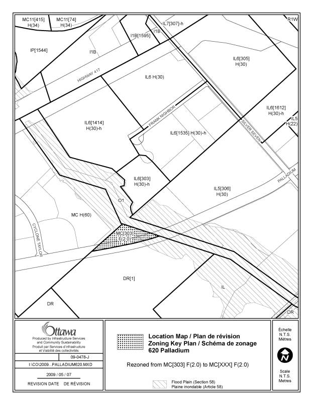
1. 620 Palladium Drive Ward 6 |
Exception [303] was erroneously applied to this site. This
amendment corrects this anomaly and implements the former Kanata zoning
(amending By-law 2007-169) and permits portions of the accessory parking
spaces to project into the flood plain. |
1. Amend the zoning maps to rezone the property from
MC[303] F(2.0) to MC[XXX] F(2.0) as shown in Document 3 2.
Add the new exception to Section 239 with the following provisions -minimum 2 m. wide landscaped buffer in a parking lot
abutting a street -no loading spaces are required for office use with less
than 12,000 square metres of gross floor area -despite Section 58(1), a maximum of 8 parking spaces may
be located within the regulatory flood plain of the Carp River subject to
approval by the Mississippi Valley Conservation Authority |
|
2. 594 Rideau Street and 165 Charlotte Street Ward 12 |
An Ontario Municipal Board Order has been issued for this
property which must be reflected in the zoning by-law. The site will be rezoned to a new
exception in the TM6 zone, with an increase in maximum permitted height from
19 to to 22 metres; with the FSI retained at F(3.0). A holding zone will be applied, as per the
OMB Order. This implements the Uptown
Rideau Community Design Plan. |
Amend the zoning map to rezone the affected lands to a TM6
exception zone (TM6 -[XXX]), with the existing F(3.0), and with a revised
height suffix of H(22), as well as a holding symbol (-h). Amend Part 15, Section 239 to add the following new
exception: [XXX] in the first column; add the zone code
"TM6[XXX] F(3.0) H(22)-h" in the second column as the applicable
zone; add "apartment dwelling, mid-high rise" in the third column
as an additional permitted use; and add the following text to Column V
Provisions: -maximum permitted height for apartment dwelling, mid-high
rise is 7 storeys, -no front yard setback is required for the first 6
storeys, however a minimum front yard setback of 2 metres is required above
the 6th storey, and -where an outdoor patio is located at the corner of a
corner lot, the maximum front yard setback is 4 metres but only in any area
directly in front of the restaurant use that the outdoor patio is accessory
to and only for a maximum total length of 6 metres, -any outdoor patio is subject to Section 85, -an additional 3-metre interior side yard setback is
required above the sixth storey where the maximum building height is more
than 16 metres, -the minimum rear yard setback is 7.5m with an additional
3 metre rear yard setback required above the sixth storey where the maximum
building height is more than 16 metres -dwelling units may occupy a maximum of 45% of the ground
floor level, provided that no dwelling unit on the ground floor level is
located within 9.5 metres of Rideau Street, -non-residential uses located on the ground floor of a
building on a lot abutting Rideau Street must provide direct pedestrian
access to the street, - a minimum of 18.5 m 2 total amenity area must be provided for
each dwelling unit, of which half must be provided as uncovered outdoor
amenity area, -the holding symbol “h” on the lands zoned TM6[XXX] F(3.0)
H(22)-h on the zoning map, may only be lifted when: (i) the combined
sewer system serving the site has been improved or replaced to the extent
necessary to facilitate the increased sewer’s capacity requirements that
would be generated by development of the property in accordance with the full
potential of the provisions of this exception zone, and (ii) a site plan
control application has been approved, including architectural elevations,
for a mixed use development on the property, and the extent of the
right-of-way widening on Rideau Street has been determined and the land
conveyed to the City. |
|
3. TM6 subzone Section 198 (6) (a) |
The use "shelter" is listed as a permitted use
in the TM6 subzone, with the latter having been created as a result of the
Uptown Rideau Community Design Plan.
The subzone and was created prior to the implementation of the Ward 12
Rideau-Vanier interim control study and rezoning amendment. Council approved the Ward 12
recommendation to remove the use shelter from the TM zones, as the use would
not be appropriate along traditional mainstreets. A motion was passed by Planning and Environment Committee in
June 2008 directing staff to review the use in the Mainstreet designation of
the Official Plan. Recent discussions on the new draft Official Plan
dealing with this issue have resulted in the recommendation to prohibit the
use in the Traditional Mainstreet designation. |
Amend Section 198 (6) (a) to delete shelter from the list
of permitted uses in the TM6 subzone |
|
4. TM6
Subzone Paragraph
198 (6) (d) |
"Special needs house" (group home), was listed
as one of the uses to which the former paragraph 321y of Zoning By-law 93-98,
applied. The new paragraph (d) of
Subection 197 (6) should have included "group home" in the list of
uses |
Amend paragraph 198 (6) (d) to add the use "group
home" immediately following the listed use "dwelling unit". |
|
5. R4 Zones Table 162B - Additional provisions, Endnote 2
applicability to converted dwellings R4 Zone -Subsection 161 (7) |
This is a technical glitch only. Endnote 2 refers, in
part, to the maximum number of units permitted in a converted dwelling,
apartment building or stacked dwelling; but the Endnote number identified in
Column XI of Table 162B is noted as applicable to apartment dwelling,
low-rise and stacked dwelling. This is because the term "converted dwelling" is
not listed in Table 162A, which is the where the reference to the applicable
Endnote is noted. Users of the zoning by-law do not have the information
that Endnote 2 applies to converted
dwelling. It is recommended that a sentence be added under Section 161
(7) indicating that converted
dwellings are also subject to Table 162B, Endnote 2 wherever it is referenced
in Column XI of Table 162B. |
Amend Subsection 161 (7) to add the following text
immediately following the first sentence by deleting the period and replacing
it with a semi-colon and text as follows: "; and in the case of a converted dwelling, Table
162B Endnote 2 applies in those subzones where it is referenced in Column XI
of Table 162B. |
|
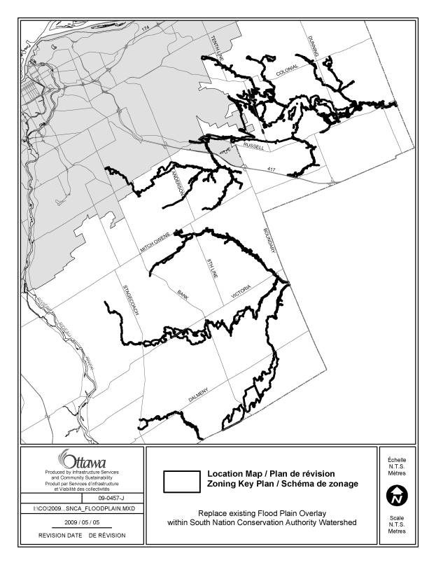
6. South Nation
Conservation Area Watershed (former Goucester area) Ward 10 |
The floodplain mapping
received from South Nation Conservation Authority (SNCA) was a different
projection than the one employed by the City of Ottawa. During automated translation to our
standard projection, the floodplain linework was shifted improperly. A new floodplain file for SNCA has been
created using an updated version of the software. City of Ottawa and SNCA
staff are working closely to verify the recently translated SNCA floodplain
is accurately located. We will continue to
encourage the adoption of the provincial projection standard thereby,
avoiding any future need for such conversions. Regardless, any projection
problems will be corrected as soon as possible to ensure an accurate
reflection of the floodplain overlay on the zoning maps. |
Amend the zoning map to replace the existing floodplain
overlay for the South Nation River Watershed with the revised overlay as
shown on Document 3. |
|
7. Section 132 (1) and (2) |
Under By-law 2009-18,
these two subsections should have been revised to remove reference to
permitting “up to three rooming units in the principal dwelling units of” a
number of low-density residential dwelling types. The wording of the recommendation was faulty and as a result,
this recommendation was never implemented. It is important to
revise these clauses to ensure that a maximum of either two or three rooming
units depending on the case, is for the whole of the dwelling, and not for
each principal unit within the whole of the dwelling. This would ensure that a total of three
rooming units would be permitted for the whole of a semi-detached,
duplex or multiple unit dwelling. |
the words “ …“the principal dwelling units of …”, so that the clauses would read, in part,
as follows: (1). Up to three rooming units are permitted in a detached
dwelling, a linked-detached dwelling, a semi-detached dwelling, a duplex
dwelling, and a multiple attached dwelling in the R1, R2, R3, R4 and R5
zones. (2) Up to two rooming units are permitted in a detached
dwelling, a linked-detached dwelling, a semi-detached dwelling and a duplex
dwelling in the VM, V1, V2, V3, RU and RR zones.” |
|
8. 5943 Hazeldean Road Former R1-20 Zone in former Goulbourn and Exception [1314]
under Zoning By-law 2008-250 |
In 2006, Council adopted a zoning amendment creating two specific exceptions reflecting a proposed residential subdivision. In transferring the exceptions to the new comprehensive Zoning By-law 2008-250, an error was made in respect of the minimum rear yard setback applicable to a portion of the lands formerly zoned R1-20 under the former Goulbourn Zoning by-law 40-99, now zoned R1MM [1314]. The minimum rear yard setback should be 7, and not 9, metres. |
LIST OF ANOMALIES
AND MODIFICATIONS
TO ZONING BY-LAW
2008-250 FOR CONSIDERATION
BY AGRICULTURAL AND RURAL AFFAIRS COMMITTEE DOCUMENT 2
|
Item No |
Objective of Amendment |
Proposed Amendment |
|
1. South Nation Conservation Area Watershed (former Cumberland, Gloucester and Osgoode areas)
Wards 19 and 20 |
The floodplain mapping
received from SNCA was a different projection than the one employed by the
City of Ottawa. During automated
translation to our standard projection the floodplain linework was shifted
improperly. A new floodplain file
for SNCA has been created using an updated version of the software. City of
Ottawa and SNCA staff are working closely to verify the recently translated
SNCA floodplain is accurately located.
We will continue to
encourage the adoption of the
provincial projection standard
thereby, avoiding any future need for such conversions. Regardless,
any projection problems will be corrected as soon as possible to ensure an
accurate reflection of the floodplain overlay on the zoning maps. |
LIST OF
SITE-SPECIFIC LOCATION MAPS DOCUMENT
3
|
Location Maps (attached) |
|
620 Palladium Drive |
|
594 Rideau Street and 165 Charlotte Street |
|
South Nation Conservation Area Watershed |