|
2. COMPREHENSIVE ZONING
BY-LAW 2008-250: ANOMALIES AND MINOR CORRECTIONS - NINTH REPORT RÈGLEMENT DE ZONAGE GÉNÉRAL
2008-250 : ANOMALIES ET CORRECTIONS MINEURES – NEUVIÈME RAPPORT |
Committee recommendationS as amended
That Council approve:
The amendments recommended in Column 3 of Document 1, to correct anomalies
in Zoning By-law 2008-250, as amended by the following:
a. The
addition of Item 23 (85 Range Road) to Document 1, and the addition of the
associated location map to Document 2;
b. The
insertion of the location map of 4269 Limebank Road in Document 2, immediately
following the map for 491, 495 Richmond Road;
c. That there be no further notice pursuant to Section 34 (17) of the Planning
Act.
RecommandationS modifÉes DU Comité
Que le Conseil approuve :
les modifications recommandées dans la Colonne 3 du
Document 1 afin de corriger des anomalies dans le Règlement de zonage 2008-250,
modifiée par les changements suivants :
a. en ajoutant le point 23 (85 chemin
Range) au Document 1, et le plan de situation connexe au Document 2;
b. en insérant la carte du 4269, chemin
Limebank au Document 2, immédiatement à la suite de la carte des 491 et 495,
chemin Richmond;
c. qu’aucun autre avis ne soit donné en
vertu du paragraphe 34 (17) de la Loi sur l’aménagement du territoire.
Documentation
1.
Deputy
City Manager's report, Infrastructure Services and Community Sustainability,
dated 28 October 2009 (ACS2009-ICS-PGM-0215), as amended.
Report to/Rapport au :
Planning and Environment Committee
Comité de l'urbanisme et de l'environnement
and Council / et au Conseil
28 October 2009 / le 28 octobre 2009
Submitted
by/Soumis par : Nancy Schepers, Deputy City Manager, Directrice
municipale adjointe,
Infrastructure Services and Community
Sustainability, Services d’infrastructure et Viabilité des collectivités
Contact Person/Personne-ressource :
Richard Kilstrom, Manager/Gestionnaire, Policy Development and Urban
Design/Élaboration de la politique et conception urbaine, Planning and Growth
Management/Urbanisme et Gestion de la croissance Élaboration de la politique et
conception urbaine
(613) 580-2424 x22653,
Richard.Kilstrom@ottawa.ca
SUBJECT:
|
COMPREHENSIVE ZONING BY-LAW 2008-250:
ANOMALIES AND MINOR CORRECTIONS - NINtH REPORT |
|
|
|
OBJET :
|
RÈGLEMENT
DE ZONAGE général 2008-250 : ANOMALIES ET CORRECTIONS MINEURES – NEUVIÈME
RAPPORT |
REPORT
RECOMMENDATION
That Planning and Environment Committee recommend that
Council approve the amendments recommended in Column 3 of Document 1, to
correct anomalies in Zoning By-law 2008-250.
RECOMMANDATION DU RAPPORT
Que le Comité de
l’urbanisme et de l’environnement recommande au Conseil d’approuver les
modifications recommandées dans la Colonne 3 du Document 1 afin de corriger des
anomalies dans le Règlement de zonage 2008-250.
BACKGROUND
On June 25, 2008 City Council adopted the new Comprehensive Zoning By-law 2008-250 that affects all properties within Ottawa. By-law 2008-250 replaces the 36 Zoning By-laws of the former municipalities that were amalgamated in 2001. Since the adoption of the Zoning By-law, staff has been identifying anomalies that require correction, and reports to correct the anomalies are being forwarded to Committee and Council on a regular basis. This report details recommended amendments to correct a number of the identified anomalies in the urban area of the City.
DISCUSSION
Since the adoption of the Zoning By-law 2008-250, staff has monitored the new by-law and has identified certain anomalies that are being recommended for correction. Document 1 provides staff recommendations to Planning and Environment Committee on the anomalies, and includes details of the recommended amendments in the urban area in Column 3 of Document 1. Document 2 contains the maps showing the location of zoning map corrections.
The
amendments are intended to correct mapping and text reference errors in the
implementation of Council-approved changes that were not accurately reflected
in the Comprehensive Zoning By-law.
RURAL IMPLICATIONS
N/A
CONSULTATION
Notice of the public meeting to deal with these anomalies and corrections was provided in The Citizen and Le Droit, with a listing of the addresses and provisions subject to correction. As well, interested parties have been notified by individual mail.
COMMENTS BY
THE WARD COUNCILLOR(S)
N/A
LEGAL/RISK MANAGEMENT IMPLICATIONS
These changes are of a routine nature to correct anomalies and do not have any legal/risk management implications.
CITY STRATEGIC
PLAN
N/A
TECHNICAL IMPLICATIONS
N/A
FINANCIAL IMPLICATIONS
N/A
SUPPORTING DOCUMENTATION
Document 1 List of Anomalies and Modifications to Zoning By-law 2008-250 for consideration by Planning and Environment Committee
Document 2 Location
Maps
DISPOSITION
Planning and Growth Management Department to prepare the implementing by-law and forward it to Legal Services who will then forward the by-law to City Council.
LIST
OF ANOMALIES AND MODIFICATIONS TO ZONING
BY-LAW
2008-250 FOR CONSIDERATION BY PLANNING
AND ENVIRONMENT COMMITTEE AMENDED DOCUMENT 1
|
Item |
Objective of Amendment |
Proposed Amendment |
|
1. Section 54 -Definition of conversion |
The phrase, use created by the
conversion must be a permitted use in the zone, is noted twice. The second instance of the phrase should
be deleted. |
Amend Section 54, Definitions, “conversion”, to delete the second instance of the phrase, use created by the conversion must be a permitted use in the zone, so that the definition would read: Conversion means the alteration of, but not demolition of a residential
use building to increase the number of principal dwelling units or
rooming units, resulting in the creation of a use which must be
a permitted use in the zone and does not include the creation or
addition of a secondary dwelling unit; and converted has a
corresponding meaning. (conversion) |
|
2. R5 purpose statement wording |
The word “that” is missing, and should be
added to the fifth item under the R5 Purpose Statement |
Amend R5 purpose statement (5), so that
the clause would read: (5) regulate development in a manner
that is compatible with existing land
use patterns so that the mixed building form, residential character of a
neighbourhood is maintained or enhanced; and |
|
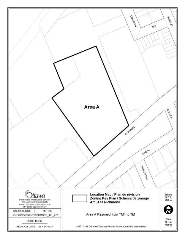
3. 471, 473 Richmond Road Ward 7 |
A typographical error occurred on the
zoning map for this property. The TM
zone, which is the appropriate zone and is consistent with the zoning of all
other adjacent properties, should
have been applied instead of the TM1. |
Amend the zoning map by rezoning the
property from TM1 to TM Amend columns II and V of exception
157 in Section 239 to change the zone code TM1 to TM |
|
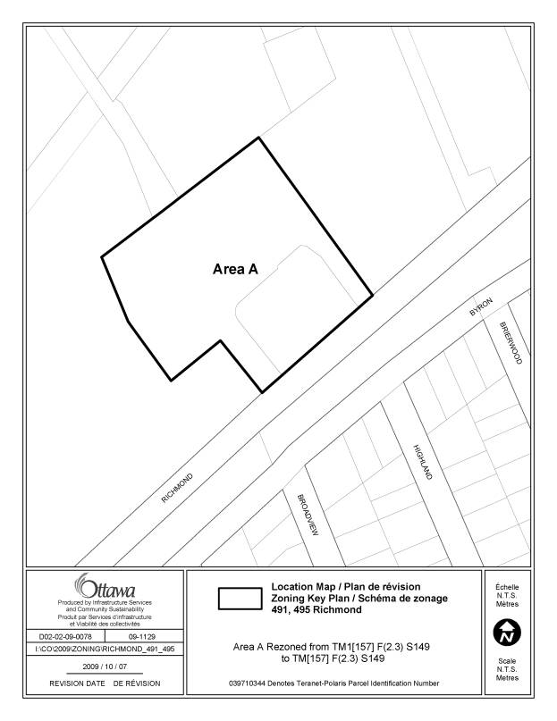
4. 491, 495 Richmond Road Ward 7 |
A typographical error occurred on the
zoning map for this property. The TM
zone, which is the appropriate zone and is consistent with the zoning of all
other adjacent properties, should
have been applied instead of the TM1. |
Amend the zoning map by rezoning the
property from TM1[157] F(2.3) S149 to TM [157] F(2.3) S149 |
|
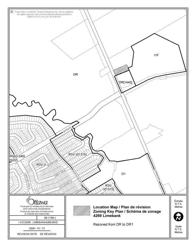
5.
4269 Limebank Ward 22 |
Under the former Gloucester Zoning By-law 333 of 1999, the property was zoned FG – Future Growth. The zoning permitted detached dwellings, provided they existed prior to the Gloucester Zoning By-law in 1999, and providing the developed lot had a minimum 4.5m lot width, which this property meets. The site is zoned DR – Development Reserve, which carries forward the FG zoning approach, although the DR zone does not permit a detached dwelling. The lot should be zoned DR1 to continue to permit the detached dwelling as a permitted principal use. The DR1 zone complies with the proposed
redesignation of this area to Medium Density Residential in the Riverside
South Community Design Plan which permits detached dwellings amongst
mid-density residential uses. |
Amend the Zoning Map to rezone 4269
Limebank from DR to DR1. |
|
6. R4Z[1296] Ward 19 |
The former Cumberland Zoning By-law zoned the lands R5A-X3 which added stacked
dwellings as a permitted use. In
transferring the site-specific exception, the regulations were written as
required for multiple attached dwellings rather than for stacked dwellings. |
Amend Exception [1296], Column V
Provisions, to replace the term
“multiple attached dwellings” with
“stacked dwellings” wherever the term appears |
|
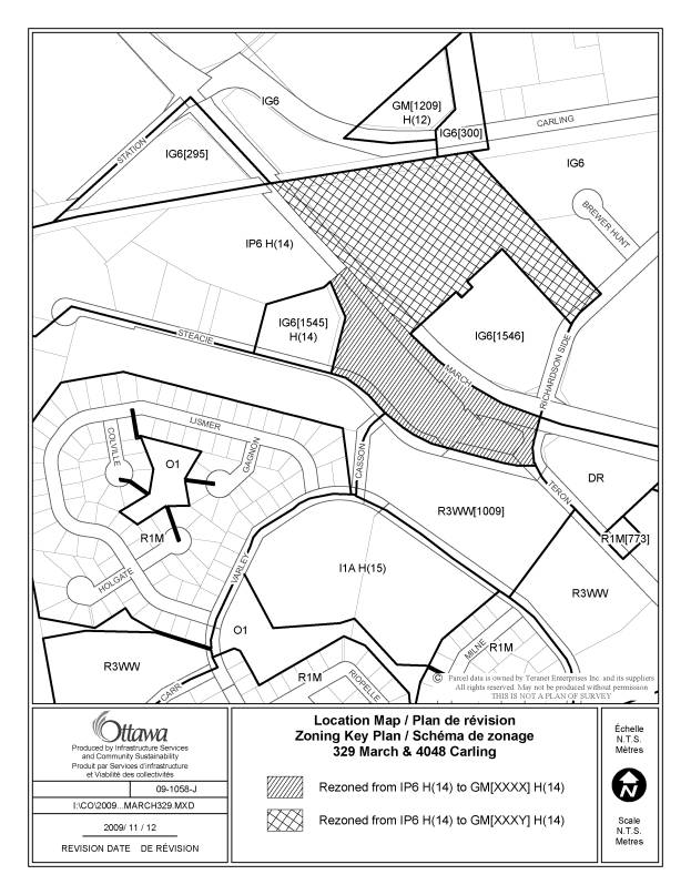
7. 329 March Road and 4048 Carling Avenue Ward 4 |
Under the former Kanata Zoning By-law
Number 132-93, these two properties were zoned commercial zones, C1S(1) and
C1S(2). The sites are occupied with commercial uses including retail, retail
food, restaurant and office. Official Plan 2003 originally designated these
lands as an “Enterprise” designation and on this basis the draft of the
Comprehensive Zoning By-law zoned these lands industrial. There was an appeal
to the Official Plan for these lands which subsequently led to a
redesignation to General Urban. However, this change was not reflected in the
adopted Zoning By-law. Given the nature of the existing development on the
site, it is appropriate to change the zoning of the lands to reflect the
former commercial zoning of these lands. |
Amend the Zoning Map, to rezone the
subject lands, as shown on Document 2, from IP6 H(14) to GM[xxxx]
H(14) and GM[xxxy] H(14). Add a new exception to Section 239 to
permit at 329 March Road, only the following uses: -
bank -
bank machine -
convenience store -
day care -
instructional facility -
medical facility -
office -
personal service business -
post office -
recreational and althletic facility -
restaurant full-service -
restaurant fast-food -
retail -
retail food store -
service and repair shop -
technology industry Add a new exception to Section 239 to
permit at 4048 Carling Avenue, only the following uses: -
automotive dealership -
bank -
bank machine -
bar -
convenience store -
day care -
drive through facility -
instructional facility -
medical facility -
office -
personal service business -
post office -
recreational and althletic facility -
restaurant full service -
restaurant fast-food -
retail -
retail food store -
service and repair shop -
technology industry |
|
8. MC [1331] F(1.25) H(34) Property on the southwest corner of Baseline
Road and Woodroffe Avenue Ward 8 |
The wording of exception [1331] is unclear and requires clarification |
Amend the wording of exception [1331] by
deleting the words in Column V – Provisions, and replacing them with, “The
limitation on location of the principal use parking lot noted in Section
191(1)(b) does not apply”. |
|
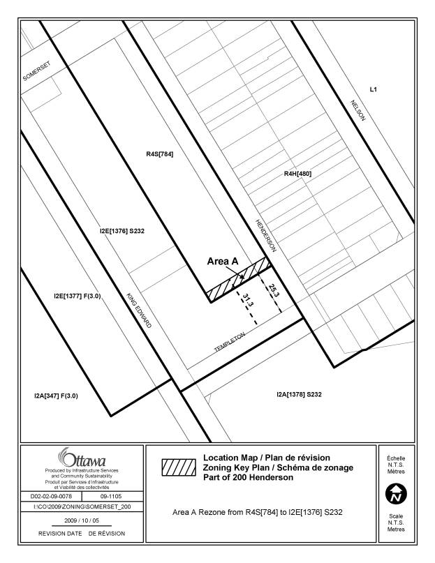
9. Part of 200 Henderson Avenue Ward 12 |
The boundary shown on the zoning map of
the I2E [1376] S232 zone in the vicinity of the corner of Henderson Avenue
and Templeton Street is incorrect.
The correct dimensions for this zone are as shown in Schedule 232, and
results in a small amount of land that must be rezoned from the R4S zone to
I2E [1376] S232. |
Amend the boundaries of the zoning map so
that they correspond properly with Schedule 232. A strip of land will be rezoned from R4S [784] to I2E [1376]
S232, as shown in Document 2. |
|
10. 260 Beechwood Avenue Exception [1279] Ward 12 |
In Exception 1279 Column II, the zone
code TM8 [1279] H(10) is incorrect .
It should be TM8 [1279] H(15) as per the zoning map. |
Amend Exception [1279], Column II by
deleting the zone code”TM8
[1279] H(10)” and replacing
it with “TM8 [1279] H(15)”. |
|
11. 2030 Trim Road Exception [214] Ward 19 |
The former Cumberland zoning by-law
included front yard and corner side
yard setbacks that are not correctly reflected in Exception [214]. |
|
|
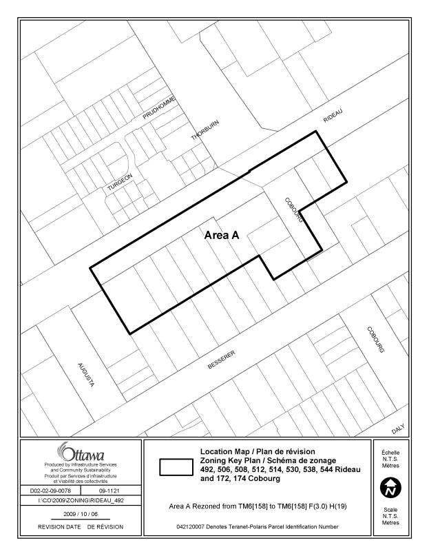
12. 492-544 Rideau, 172-174 Cobourg Ward 12 |
These properties were subject to the
Zoning By-law amendment 2005-24 to
implement the Uptown Rideau Community Design Plan , but the floor space
indexes, shown on the zoning map by the symbol “F (XX)”, that were to apply
to these sites was inadvertently omitted from the zoning map |
Amend the zoning map as shown on Document
2 for the following addresses: -
492, 506, 508, 510, 512, 514,
530, 538, 544 Rideau and 172, 174 Cobourg to be rezoned from TM6 [158] to
TM6 [158] F(3.0) H(19). |
|
13. 308-328 Rideau Street and 263 to 287
Besserer Street Exception [1603] Ward 12 |
In transferring the 2008 area-specific
rezoning that was created under former Ottawa Zoning By-law 93-98 Exception
[990], the regulation that states that no FSI applies was inadverntely
omitted |
Amend Section 239, Exception [1603],
Column V-Provisions to add the following regulation: -no floor space index applies |
|
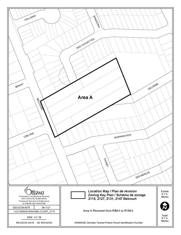
14. 2115-2147 Belcourt Ward 2 |
Incorrect zoning code is shown on the
zoning map for 2115-2147 Belcourt.
RIM-h should be R1M-h |
Amend the zoning map as shown on Document
2 to rezone 2115, 2127, 2131, 2147
Belcourt from RIM-h to R1M-h. |
|
15. IL3
Zone Ward 8 |
A typographical error in the description
of the IL3 zone makes it unclear about the uses that are also permitted in
the subzone and under what conditions. |
Amend Section 204(3)by: -
adding the following text to
204(3)(a): “(i) they being located in a building
containing one or more of the permitted uses of the IL3 Subzone, other than a
restaurant, full service; 21. there being no visible indication of the use from the exterior of
the building; 21.
access being only possible from
within the building; and, 21.
the cumulative gross leasable floor
area they occupy not exceeding 10% of the permitted gross leasable floor
area or 280 square metres, whichever is greater;
restaurant, fast food
restaurant, take-out” -
deleting 204(3) (e). |
|
16. 1080 Bank Street Ward 17 |
When creating the minimum interior side yard abutting a residential zone for a mixed-use building of 1.18m, there was an incorrect assumption that a building that had an office use and a commercial use was considered in the Zoning By-law as a mixed use building. However, a mixed-use building is typically referred to when there is a mix in land use categories, such as in the case of a residential use with a commercial use. Given that the development does not include a residential component, the provision should be reworded; to keep the provision simple, recommend removal of the limitation on the interior side yard based on a certain type of building. |
Amend Exception 98 of Section 239
– Exceptions, by rewording Column V– Provisions to remove reference to a
mixed use building, so that the first provision would read: “-minimum interior side yard abutting
a residential zone: 1.18m” |
|
17. 123 Huntmar Drive |
In transferring the former Goulbourn
zoning of this site, some of the site-specific regulations were omitted in
error and should be added to Exception [1455] |
Amend Section 239, Exception [1455] to
add the following: -under zone requirements for
semi-detached and multiple attached dwellings:
3.amend vii)
maximum lot coverage to add …”and in the case of multiple attached dwellings
fronting on a rear lane, there is no maximum” immediately following the
phrase “maximum lot coverage is 65%,” |
|
18. 4232 Innes Road Ward 19 |
In transferring the site-specific zoning
of this site, omitted by error, was a cross-reference between this site, and
other abutting and adjacent lots in the Exception [210], wherein all of the
affected lots were to be treated as one lot for by-law purposes, and with a
total maximum combined total gross leasable floor area of 35,000 m2 |
Amend Column V-Provisions, Exception [210], fourth bullet to
delete the phrase "and the total gross leasable floor area on the lands
must not exceed 35,000 m2 ", so that the wording would be
"- despite any provision to the contrary, the lands within this
exception zone are considered one lot for zoning purposes" Amend Column V-Provisions,
Exceptions [210] and [213] to add a new provision that would read: “-the lands zoned AM[210] H(18.5), GM1[210]
H(18.5) and AM[213] H(21) are one lot for zoning purposes with respect to
maximum permitted gross leasable floor area which must not exceed 35 000m2." |
|
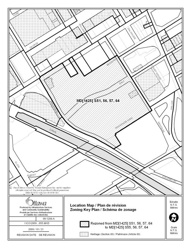
19. Lands bounded by the Mackenzie King
Bridge, Colonel By Drive, Nicholas Street and Rideau Street Ward 12 |
One of the Schedule reference numbers is
incorrect on the Zoning Map, and should be corrected to ensure that the
correct schedules apply to this site. |
Amend the Zoning Map to replace one of
the Schedule references from S51 to S55, so that the correct zoning on the
land would be MD[1425] S 55, 56, 57, 64. |
|
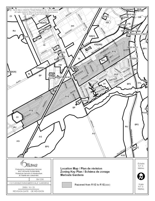
20. Merivale Gardens neighbourhood |
A neighbourhood rezoning of Merivale
Gardens that occurred in 1988 (By-law 130-88) was inadvertently omitted
during the Nepean Zoning By-law Consolidation prior to amalgamation. This omission was then carried forward
into Zoning By-law 2008-250. The City
Clerk and Solicitor Departmetn has confirmed that By-law 130-88 is still in
effect and was an Ontario Municipal Board approved zoning by-law
amendment. The area will be rezoned to
an exception zone to recognize the larger minimum lot width of 30 metres. |
Amend the Zoning Map to rezone the lands
from R1E to R1E [xxx], with said lands described to include:
Create a new
Exception [xxx] to apply to the above-noted lands zoned R1E, that requires a
minimum 30 m lot width. |
|
21. Rideau Street TM6 Subzone – Front
yard setbacks |
The regulations applicable in Subsection
197 (4), including the front yard setback in the case of a hydro pole or
power line, or outdoor patio, should also apply in the case of the TM6
Subzone. |
Amend Section 198 (6), Table 197A –
Provisions for the TM6 Subzone, for both row (i) Minimum front yard setback
and row (ii) maximum front yard, Column II Provisions to add the following
text immediately before the first case: “In addition to the front yard setback
requirements of Section 197 (4) (a), (b), (c), and (e), the following also
applies:” |
|
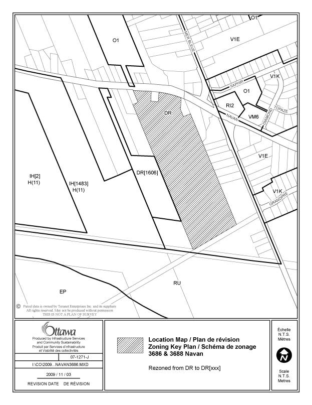
22.Mer
Bleue Golf Course 3686 and 3688 Navan Road Ward 2 |
Under the previous Gloucester FG – Future Growth Zoning for the site, the permitted main use under which the Site Plan was approved was "outdoor recreational uses". At that time, the developer was advised that a golf course and driving range fell under "outdoor recreational uses", and as such, the Site Plan Control Approval was granted for Phase I of the Mer Bleue Golf Course. The current zoning DR – Development Reserve, generally reflects Future Growth zones that existed in some of the former municipal zoning by-laws. However, the DR zone does not permit a golf course, nor a driving range. Because the golf course and driving range exist, and the site plan application was approved on the basis that the use was permitted, the zoning for the site should be corrected to reflect the permission for the existing use. Note that an outdoor driving range falls within the definition of golf course, and therefore need not be mentioned in the exception. It is the intent of the landowner to return and receive approval for phase II on the same said lands. The golf course and driving range have existed for a number of years, prior to phase I site plan control approval. |
Amend the Zoning Map to rezone the lands
from DR to DR [1548] to permit the
existing golf course. Amend row 1548, Section 239, Exceptions, to add the zone code DR [1548] to
column II to permit a golf course. |
|
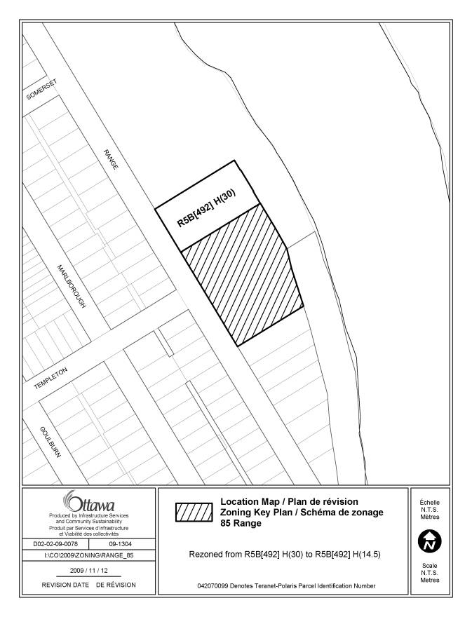
23. 85 Range Road Ward 12 |
In the new
Comprehensive Zoning By-law, it was intended to remove floor space indexes in
the new R5, mid-high rise residential zones across the city and replace them
with maximum height limits as a more transparent means of limiting the height
in those zones and to allow for additional intensification in line with the
City’s new Official Plan approved in 2003.
Thus the property was zoned as R5B
[492] H(30), eliminating the former 1.0 maximum floor space index to reflect
the existing 30 metre height of the building, given there was no maximum
building height under the former City of Ottawa Zoning By-law, 93-98. The property contains
a ten-storey apartment building, which was built in 1957, on the northern
third of the lands and a surface required parking area on the southern
two-thirds. The site is located to the south of Strathcona Park, near the
Rideau River. The first former
Ottawa Zoning By-law, AZ-64, in a 1983 amendment, imposed a 10.7 metre height
limit and a FSI limit of 1.0 to implement the recently adopted Sandy Hill
Secondary Plan. In 1985,the
successor Zoning By-law, Z2-K, carried forward these zoning provisions. Under Zoning By-law 93-98, the R6A[386] F(1.0) zoning of the property recognized the existing building by eliminating the maximum
building height, but retained the FSI
limit of 1.0. The subject property
is designated as Residential, Low-Profile in the Sandy Hill Secondary
Plan. However, it has recently been
determined that the zoning change made as part of By-law 2008-250 may not be
in compliance with the Sandy Hill Secondary Plan, whereby a Low Profile
designation is generally intended to reflect a building up to four storeys.
The zoning as it is would permit the construction of another ten storey high-rise
on the lands. To correct this anomaly, the southern two-thirds of the property should be rezoned to a maximum height limit of 14.5 metres. The northerly third, containing the existing ten-storey apartment building, would retain the existing 30 metre height limit. This is in line with the City’s approach of eliminating FSI’s to reflect existing heights but still allow for some intensification of those sites. A 14.5 metre height limit on the southern two-thirds of the property will reflect the Low Profile designation and is similar to the height for low-rise, four storey apartment buildings in the inner City. |
Amend the zoning map by rezoning the southern two-thirds of the
subject property from R5B [492] H(30) to R5B [492] H(14.5) as shown in Document 2. |
LIST OF SITE-SPECIFIC LOCATION MAPS AMENDED
DOCUMENT 2
|
Location Maps (attached) |
|
491,
495 Richmond Road |
|
4269 Limebank Road |
|
329 March Road and 4048 Carling Avenue |
|
Part of 200 Henderson Avenue |
|
492-544 Rideau, 172-174 Cobourg |
|
2115-2147 Belcourt |
|
Area zoned MD [1425] S51, 56, 57, 64 bounded by Mackenzie King Bridge, Colonel By Drive, Nicholas and Rideau Streets |
|
3686 and 3688 Navan Road |
|
85 Range Road |