|
4. ZONING - 3860 -
3930 riverside drive ZONAGE - 3860 - 3930,
PROMENADE RIVERSIDE |
Committee recommendationS
(This matter is subject to Bill 51)
That Council approve
amendments to Zoning By-law 2008-250, to change the zoning of 3860 and 3930
Riverside Drive:
a.
From GM1 [108] H(137a.s.l.) (General Mixed Use Subzone 1, Exception
108, Maximum Building Height 137 Metres Above Sea Level) to GM1[1719] S215
H137a.s.l.) (General Mixed Use Subzone 1, Exception 1719, Schedule 215, Maximum
Building Height 137 Metres Above Sea Level),
b.
From O1C (Open Space Subzone 1C) to GM1[1719] S251 H(137a.s.l),
(General Mixed Use Subzone 1, Exception 1719, Schedule 215, Maximum Building
Height 137 Metres Above Sea Level)
c.
From GM1[108] H(137a.s.l.) (General Mixed Use Subzone 1, Exception
108, Maximum Building Height 137 Metres Above Sea Level to EP (Environmental
Protection Zone, and
d.
From O1C (Open Space Subzone
1C) to EP (Environmental Protection Zone);
as shown in Documents 1
and 2 and detailed in Document 3.
RecommandationS DU Comité
(Cette
question est assujettie au Règlement 51)
Que le Conseil approuve les modifications suivantes au Règlement de
zonage 2008-250, visant à changer la désignation de zonage des propriétés
situées aux 3860 et 3930, promenade Riverside :
a.
De GM1 [108] H(137a.s.l.) (sous-zone
d’utilisations polyvalentes générale 1, exception 108, hauteur maximale des
immeubles : 137 mètres au-dessus du niveau de la mer) à GM1[1719] S215
H137a.s.l.) (sous-zone d’utilisations polyvalentes générale 1, exception 1719,
annexe 215, hauteur maximale des immeubles : 137 mètres au-dessus du
niveau de la mer);
b.
De O1C (sous-zone d’espaces verts
1C) à GM1[1719] S251 H(137a.s.l) (sous-zone d’utilisations polyvalentes
générale 1, exception 1719, annexe 215, hauteur maximale des immeubles :
137 mètres au-dessus du niveau de la mer);
c.
De GM1[108] H(137a.s.l.) (sous-zone
d’utilisations polyvalentes générale 1, exception 108, hauteur maximale des
immeubles : 137 mètres au-dessus du niveau de la mer) à EP (zone de
protection de l’environnement);
d.
De O1C (sous-zone d’espaces verts
1C) à EP (zone de protection de l’environnement);
comme l’illustrent les documents 1 et 2 et le précise le document 3.
Documentation
1.
Deputy
City Manager's report, Infrastructure Services and Community Sustainability,
dated 23 November 2009 (ACS2009-ICS-PGM-0221).
2. Extract of Draft Minutes, 8 December 2009.
Report to/Rapport au :
Planning
and Environment Committee
Comité de l'urbanisme et de l'environnement
and Council / et au Conseil
23 November 2009 / le 23 novembre 2009
Submitted
by/Soumis par : Nancy Schepers, Deputy City Manager/Directrice municipale adjointe,
Infrastructure Services and Community Sustainability/Services
d’infrastructure et Viabilité des collectivités
Contact
Person/Personne-ressource : John Smit, Manager/Gestionnaire, Development
Review-Urban Services/Examen des projets d'aménagement-Services urbains,
Planning and Growth Management/Urbanisme et Gestion de la croissance
(613)
580-2424, 13866 John.Smit@ottawa.ca
|
SUBJECT: |
ZONING - 3860-3930 Riverside Drive
(FILE NO. D02-02-08-0116) |
|
|
|
|
OBJET : |
REPORT RECOMMENDATIONS
That the
Planning and Environment Committee recommend Council approve amendments to
Zoning By-law 2008-250, to change the zoning of 3860 and 3930 Riverside Drive:
a. From GM1 [108] H(137a.s.l.) (General
Mixed Use Subzone 1, Exception 108, Maximum Building Height 137 Metres Above
Sea Level) to GM1[1719] S215 H137a.s.l.) (General Mixed Use Subzone 1,
Exception 1719, Schedule 215, Maximum Building Height 137 Metres Above Sea
Level),
b. From O1C (Open Space Subzone 1C) to GM1[1719] S251
H(137a.s.l), (General Mixed Use Subzone 1, Exception 1719, Schedule 215,
Maximum Building Height 137 Metres Above Sea Level)
c. From GM1[108] H(137a.s.l.) (General
Mixed Use Subzone 1, Exception 108, Maximum Building Height 137 Metres Above
Sea Level to EP (Environmental Protection Zone, and
d. From O1C (Open Space Subzone 1C) to EP (Environmental
Protection Zone);
as shown in Documents 1 and 2 and detailed in
Document 3.
RECOMMANDATIONS DU
RAPPORT
Que le Comité de l’urbanisme et de
l’environnement recommande au Conseil d’approuver les modifications suivantes
au Règlement de zonage 2008-250, visant à changer la désignation de zonage des
propriétés situées aux 3860 et 3930, promenade Riverside :
a. De
GM1 [108] H(137a.s.l.) (sous-zone d’utilisations polyvalentes générale 1,
exception 108, hauteur maximale des immeubles : 137 mètres au-dessus du
niveau de la mer) à GM1[1719] S215 H137a.s.l.) (sous-zone d’utilisations polyvalentes
générale 1, exception 1719, annexe 215, hauteur maximale des immeubles :
137 mètres au-dessus du niveau de la mer);
b. De O1C (sous-zone
d’espaces verts 1C) à GM1[1719] S251 H(137a.s.l) (sous-zone d’utilisations
polyvalentes générale 1, exception 1719, annexe 215, hauteur maximale des
immeubles : 137 mètres au-dessus du niveau de la mer);
c. De GM1[108] H(137a.s.l.)
(sous-zone d’utilisations polyvalentes générale 1, exception 108, hauteur
maximale des immeubles : 137 mètres au-dessus du niveau de la mer) à EP
(zone de protection de l’environnement);
d. De O1C (sous-zone
d’espaces verts 1C) à EP (zone de protection de l’environnement);
comme l’illustrent les documents 1 et 2 et le
précise le document 3.
BACKGROUND
The subject property, 3860 and 3930 Riverside Drive, is located at the northwest corner of Hunt Club Road and Riverside Drive. The site is situated immediately east of the Rideau River and northwest of the Ottawa Macdonald-Cartier International Airport. The site is approximately 11.5 hectares in area, with approximately 285 metres of frontage along Riverside Drive and 90 metres of frontage along Hunt Club Road. Across Riverside Drive to the east is the Hunt Club Golf Club. Adjacent to the north is the City's Uplands - Riverside Park and a low profile residential area. Immediately to the south, across Hunt Club Road is a gasoline service station. Hunt Club Road at this location includes the easterly approach to the Hunt Club Bridge across the Rideau River.
The site was formally an aggregate resource area, which has remained vacant since being depleted in the 1970s/80s. The surface of the site consists mainly of exposed soil, grass and low-lying vegetation, with trees occupying a small area in the northwest corner of the property and parts of the western perimeter. The land slopes from Riverside Drive down towards the river. This gradient is significant but has been reduced through filling operations. The southerly half of the property was obtained from the City in 2001 through an agreement for a land exchange that resulted in the City obtaining the land for Uplands - Riverside Park adjacent to the north.
Purpose of Zoning Amendment
The purpose of the proposed re-zoning is to allow retirement facilities as permitted uses in the General Mixed-Use (GM1) zone and to address appropriate refinement of the delineation of the Environmental Protection (EP) zone.
Existing Zoning
The subject property is currently zoned General Mixed-Use Zone (GM1 [108] H (137 A.S.L.)), Environmental Protection Zone (EP), and Parks and Open Space Subzone (O1C) in the Comprehensive Zoning By-law 2008-250.
The GM1 zone permits a range of uses including residential, commercial, institutional, and mixed-use in areas designated General Urban Area in the Official Plan. A variety of medium and high-density housing, including retirement homes, are permitted in the base GM zone. However, exception [108] specifically prohibits all residential uses and adds various commercial uses that would otherwise not be permitted such as a hotel, nightclub, and amusement centre. Exception [108] also outlines provisions for limiting the amount of space that can be used for commercial development and setting specific parking requirements for office use.
The EP zone allows for two uses, environmental preserve and education area, and forestry operation. The O1C subzone permits a park use only.
It is also recommended to augment the GM1 zone exception to allow the potential for parking that could serve the adjacent park. As well, it is proposed to expand and modify the delineation of the area of the Environmental Protection Zone to address the most recent available environmental evaluation of the area, by changing part of the O1C zone to EP, and modifying the division between the GM1 zone and the EP zone.
DISCUSSION
Official Plan
The Official Plan (OP) designates the easterly and southerly portions of the property, which constitutes most of the subject land, as General Urban Area. The OP states that "the General Urban Area designation permits the development of a full range and choice of housing types to meet the needs of all ages, incomes and life circumstances, in combination with conveniently located employment, retail, service, cultural, leisure, entertainment and institutional uses." The proposed zoning amendment is in keeping with the intent of the OP policies for the General Urban Area. The addition of "retirement home" and "residential care facility" uses would add a residential component to the potential development of the property, and there are numerous existing and developing supportive services and facilities nearby to the north, east and southeast The Zoning By-law indicates that "the purpose of the GM – General Mixed-Use Zone is to: (1) allow residential, commercial and institutional uses, or mixed use development in the General Urban Area ….designations of the Official Plan;" The proposed re-zoning is in keeping with the purpose of the base GM zone. City Council's recent approval of Official Plan Amendment 76 (OPA 76) maintains the intent and policies specific to the General Urban Area.
Airport Land-Use Constraints
The existing Zoning By-law prohibition of residential uses on the site stems from the Noise Exposure Forecast (NEF) and the Noise Exposure Projection (NEP) delineation, consistent with policies of Section 4.8.7 of the OP, that were in effect when the by-law provisions were established. An OP amendment in 2005 resulted in modifying policies in Section 4.8.7 and in a revision to "Schedule K, Environmental Constraints". OPA 76 carried forward this refined policy.
The 2005 amendment and Schedule K revision reflected a reduction in the area of the Ottawa Airport Operating Influence Zone (AOIZ), which had the effect of removing the subject property from the influence zone. The revisions were based at that time on information up-dated by the Airport and Transport Canada. The AOIZ is based on the more restrictive of either the 30 NEF and 30 NEP contours.
With the realignment of the AOIZ, the policy restriction on residential development no longer applies to much of the subject property, and as per the policies for the General Urban Area, residential development is supported in the area. However, in response to this application the Ottawa Airport Authority staff have provided more recent, further up-dated information on the location of the 30 NEF and 30 NEP contours, which now shows inclusion of a small part of the southwest portion of the subject property. The Authority staff have also indicated that no future reductions in the contours are anticipated. As indicated in OP Section 4.8.7, the Schedule K delineation was "drawn to coincide with physical features such as roads, creeks, rail lines and lot lines where possible", and as a restrictive limiting line is not subject to interpretation. The updated information provided by the Airport staff allows for the implementation, through a precise zoning schedule of the most recent NEF and NEP information at a level of refinement not afforded by the delineation constraints of the Schedule K review, as reflected on Document 2. Therefore, it is recommended that the prohibition on residential use only remain in effect on a small portion of the southwest part of the property as per Document 2 It should be noted that the conceptual commercial/residential development plan provided by the applicant is completely facilitated by the recommended rezoning and proposed Document 2.
Urban Natural Feature
The westerly portion of the property from approximately the upper edge of the slopes of the embankment leading to the Rideau River is designated as Urban Natural Feature in the OP. The Plan states that: "Urban Natural Features provide a valuable contribution to biodiversity and wildlife habitat in the urban area and are enjoyed by residents. Urban Natural Features are natural landscapes and may include woodlands, wetlands, watercourses and ravines. These features may occur on City, federal, provincial and privately-owned lands." The OP policies of Section 3.2.3 indicate that the purpose of the Urban Natural Feature "is to preserve natural features that are currently managed for conservation or passive leisure uses." The OP policies go on to say "uses that do not adversely affect the natural characteristics of the area, such as open air recreation; scientific, educational, or conservation uses associated with the environmental features; agriculture operations established at the time of adoption of this Plan; or forestry as defined by the Forestry Act are permitted, subject to" other applicable policies. OPA 76 upholds this intent and policy.
The OP indicates that with respect to an Urban Natural Feature "the City’s zoning by-law will reflect the most up-to-date and accurate information and therefore any changes, whether minor or major, will require an amendment to the zoning by-law. However, minor changes to the boundaries will not require an amendment to the Official Plan." The delineation of the current EP zoning of portions of the property adjacent to the Rideau River is based in part on studies, such as the Natural and Open Space Study (NOSS), commenced by the former City of Ottawa. The recommended rezoning addresses the intent of the OP policies pertaining to an Urban Natural Feature by expanding the EP zone to more completely reflect the more recent Urban Natural Areas Environmental Evaluation Study (UNAEES) of 2005. OPA 76 upholds this policy intent.
The revision to the EP zone adds an area currently zoned GM1 [108] H(137 A.S.L.) to the EP zone. The added area was identified in the UNAEES as part of Site # 147, Riverwood Park Woods and was given an environmental rating of "Moderate" in the study. In 2007 City Council approved the Urban Natural Features Strategy, which contained a strategic direction to protect sites rated as moderate and high. The area recommended for re-zoning to EP was rated within the moderate and high group. The recommendation to expand the EP zone is in keeping with the OP policy to reflect the most up-to-date information environmental information and in keeping with Council's decision to protect sites rated moderate to high in the UNAEES.
Transportation and Infrastructure
The Official Plan policies of sub-section 4.4 Water and Wastewater Servicing require adequate services for new development. The property is adequately served by water and sanitary sewer facilities to facilitate the potential variation in development afforded by the recommended re-zoning. The rezoning will not affect storm sewer provisions associated with the property, and will add uses with less traffic generating potential than other existing permitted uses. The recommended re-zoning will not increase the potential for traffic generated by development on the property. The property is served by three bus routes and adjacent to two Arterial roadways, Riverside Drive and Hunt Club Road. The City is obligated to provide for property access to facilitate development of any of the uses permitted under the zoning by-law, which would be analyzed and finalized through a site plan control application process. It is recognized by City staff and the applicant that site access options at this location would be limited to the northerly segment of Riverside Drive.
The details of the recommended zoning amendment as set out in Documents 1, 2 and 3 implement the changes requied to allow for the requested residential uses, potential park parking, the recommended revisions to the delineation of the GM1 zone, and the expansion of the EP zone.
ENVIRONMENTAL IMPLICATIONS
The recommended rezoning recognizes the most recent studies and field work pertaining to the Urban Natural Feature and modifies the EP zone delineation accordingly.
RURAL IMPLICATIONS
N/A
CONSULTATION
Notice of this application was carried out in accordance with the City's Public Notification and Consultation Policy. The comments received by the public pertained primarily to access, site development and relationship to the adjacent park and are summarized and addressed in Document 4.
COMMENTS BY
WARD COUNCILLOR(S)
Councillor Maria McRae is aware of the application.
LEGAL/RISK MANAGEMENT IMPLICATIONS
If this matter were appealed to the Ontario
Municipal Board, it is anticipated that a three- to five‑day hearing
would result. If it were necessary to
retain outside witnesses, the estimated cost would be $25,000 to $35,000 for
Planning and $30,000 to $35,000 for Transportation.
CITY STRATEGIC PLAN
The recommended rezoning is in keeping with the City Strategic Plan, Service Priorities. The proposed added uses and zoning revisions support Service Priorities for Transportation, for a Sustainable, Healthy and Active City, for Planning and Growth Management and for Infrastructure Renewal. The added use facilitates efficient use of existing transportation and services infrastructure through land use planning. The zoning changes support the policy that green spaces continue to grow and be available for residents. The added uses will support creation of a variety of housing options and integration of new growth with existing communities using existing infrastructure.
TECHNICAL IMPLICATIONS
N/A
FINANCIAL IMPLICATIONS
N/A
APPLICATION PROCESS TIMELINE STATUS
The application was not processed by the "On Time Decision Date" established for the processing of Zoning By-law amendments due to the need to undertake more detailed on-site evaluation of the natural features on the property, impact of updated airport noise information and engineering requirements.
SUPPORTING DOCUMENTATION
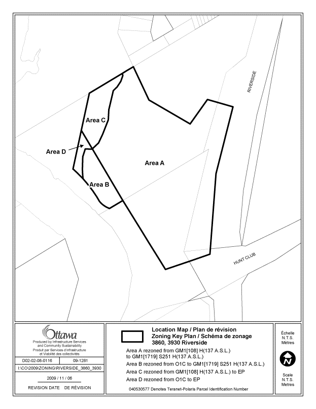
Document 1 Location
Map
Document 2 Proposed Schedule 251
Document 3 Details of Recommended Zoning
Document 4 Consultation
Details
DISPOSITION
City Clerk and Solicitor Department, Legislative Services to notify the owner, applicant, OttawaScene.com, 174 Colonnade Road, Unit #33, Ottawa, ON K2E 7J5, Ghislain Lamarche, Program Manager, Assessment, Financial Services Branch (Mail Code: 26-76) of City Council’s decision.
Planning and Growth Management to prepare the implementing by-law, forward to Legal Services and undertake the statutory notification.
Legal Services to forward the implementing by-law to City Council.
LOCATION
MAP DOCUMENT 1
PROPOSED SCHEDULE 251 DOCUMENT 2
DETAILS OF RECOMMENDED ZONING DOCUMENT 3
Proposed Changes to the Comprehensive Zoning By-law
3860 Riverside Drive
Proposed Changes to By-law 2008-250
1. Rezone
the land as follows and shown on Document 1:
Area
A to be rezoned from GM1[108] H(137 a.s.l.) to GM1[1719] S251 H(137 a.s.l.)
Area
B to be rezoned from O1C to GM1[1719] S251 H(137 a.s.l.).
Area
C to be rezoned from GM1[108] H(137 a.s.l.) to EP.
Area
D to be rezoned from O1C to EP.
2. Add a new exception, No.
1719, to Section 239 Urban Exceptions including all of the uses and provisions
of the existing exception 108, but with the following changes:
a. add the words "except retirement
home and residential care facility" after the words "- all
residential uses" in column IV,
b. change column II to say only
"GM1[1719] S251 H(137 a.s.l.)"
c. add the following provisions:
- maximum of 40% of the units in a retirement home can be dwelling units
- residential care facility and retirement home are not permitted in Area A on Schedule 251
- parking lot for a park on an adjacent property is permitted
3. Add
Document 2 to Part 17 Schedules as Schedule 251.
CONSULTATION DETAILS DOCUMENT
4
NOTIFICATION AND CONSULTATION PROCESS
Notification and public consultation was undertaken in accordance with the Public Notification and Public Consultation Policy approved by City Council for Zoning By-law amendments. One public open house meeting was also held in the community.
SUMMARY OF PUBLIC INPUT
The following summarizes comments provided by the public and the staff responses to the issues raised:
1. Comment: As the price of oil increases and supply diminishes over time, there should be as much development as possible in the central core as opposed to the out-lying suburbs and the proposed office and retirement home would make sense at this location on existing roads and bus routes.
Response: Staff and City planning policies concur with sensitive development and intensification inside the Greenbelt; the proposed rezoning is consistent with these policies.
2. Comment: The proposed senior’s building is the closest one in the design to the flight path and should be a bit further away due to aircraft noise.
Response: Proposed limitations on residential use illustrated in recommended Schedule 251 address the most recent information on potential aircraft noise impacts on the property.
3. Comment: There is no safe access, no sidewalks, especially for children, from the adjacent Quinterra community to the existing park beside the subject property; and through this development parking could be provided to also serve the park and a pathway to serve the community in conjunction with a possible connection to the existing storm water ponds along the river, perhaps with extensions to the north. Kimberwick gets flooded with parked cars during sporting events in the park. It would be nice if facilities in a seniors building were made available to the residents of the “adult life-style” community nearby.
Response: Existing agreements between the owner and the City address the need to facilitate access through the subject lands to possible future parking in the adjacent City park, and the applicant has indicated an awareness and willingness to co-operate in this regard; but the provision of the parking is not directly related to this rezoning application. Any future site plan application for the subject lands will address the potential for servicing connections to the existing stormwater management facilities and potential co-ordination with public pathway development.
4. Comment: Access to the subject property is a great challenge especially at rush-hour, and any development here should be opposed. Riverside Drive access would be unacceptable; the Riverside/Hunt Club intersection is one of the busiest and most dangerous in the City at rush hour. No vehicular access should be allowed from Kimberwick Crescent to the property. The zoning amendment should eliminate the office use and just allow the retirement home to cut down on the traffic generation. Here should be an extended right turn lane on Riverside to serve access to the property.
Response: The proposed re-zoning has no direct relationship to site access design, which will be addressed through any future site plan control applications. The recommended added “residential care facility”, and “retirement home” uses are conducive to lower yields of peak-hour vehicle trips than the some of the other currently permitted uses for the property, such as office use. There was no request to consider elimination of existing permitted uses on the property, and the existing permitted uses are considered appropriate at this location.
5. Comment: Two eight-storey apartment buildings will greatly increase the density in the area; the exception 108 provisions should be kept if the reason for imposing it in the first place remains valid. This is a very “ecological area” with lots of wildlife that could be effected, but office buildings would be no problem.
Response: The provisions of exception 108 pertaining to the property are to be maintained as per the details of the proposed rezoning, except the full prohibition on residential uses, which has been modified as per the requested amendment and in keeping with the most updated available information on potential airport noise impacts.
PUBLIC OPEN HOUSE MEETING JANUARY 8, 2009 COMMENTS
The primary issues raised at the public open house pertained to the problem of obtaining access to the subject property given the traffic congestion on Riverside Drive, and the problem of a lack of parking serving the adjacent City Park and resultant over-flow parking onto the streets in the nearby residential neighbourhood.
Response to Comments
The proposed re-zoning has no direct relationship to site access design, which will be addressed through any future site plan control application for the property. The recommended added “residential care facility”, and “retirement home” uses are conducive to lower yields of peak-hour vehicle trips than the some of the other currently permitted uses for the property, such as office use. Existing agreements between the owner and the City address the need to facilitate access through the subject lands to possible future parking for the adjacent City park, and the applicant has indicated an awareness and willingness to co-operate in this regard; but the provision of the parking is not directly related to this rezoning application.
COMMUNITY ORGANIZATION COMMENTS
Hunt Club Community Organization
The Hunt Club Community Organization provided the following comments:
“The Hunt Club
Community Organization is very concerned about the proposed change in zoning
for 3860-3930 Riverside Drive, on grounds of access requirements.
If access is to Riverside Drive, it will be at a point that is already clogged
to the maximum during
rush hours, especially in the afternoon. Access requirements of office towers
would be exercised
precisely at the times of maximum present congestion. However, access
requirements of retirement homes would be more spread out during the day.
A major problem affecting the area is traffic coming south on Riverside to turn
right on Hunt Club then south again on Prince of Wales. Traffic jams stretching
well past Uplands Drive are routine here, and on the first day of the transit
strike it stretched to Walkley Road. There is no room here for any additional
traffic load until there are major improvements to traffic flow along this
route, at a minimum a two lane right turn from Riverside onto the bridge with
green right-turn arrows to match.
In the case of office towers, traffic to and from the area would be sufficient
that traffic lights
would be required on Riverside. The principle reason why the adjacent
intersection of Riverside and Hunt Club is one of the most clogged and
dangerous in the city, both on a total accident rate and on accident rate per
vehicle, is the juxtaposition of three lights tight in a row along Hunt Club,
at Riverside, Prince of Wales, and Antares. Another light close by on Riverside
would be disastrous to traffic flow and safety along this route.
Access to Kimberwick is constrained to a strip that was planned solely as a
pedestrian link to the
activity park at the north end of the proposed area. The streets of the area
were never designed for anything like the access volume required by office
towers, although a single retirement home might be manageable.
The effects of this proposal on traffic in our community will be so large that
they must be
considered now, not after the zoning change has been passed by Council and the
precedent for this use established.
As the community association for the area, we must be actively involved in all
stages of major
planning for this area. We will require sufficient notice of all consultations
and public meetings
to be able to alert members of our community in the heavily affected areas.”
Response to Comments
The proposed re-zoning has no direct relationship to site access design, which will be addressed through any future site plan control application for the property, including any required roadway or intersection improvements directly required due to new development. The recommended added “residential care facility”, and “retirement home” uses are conducive to lower yields of peak-hour vehicle trips than the some of the other currently permitted uses for the property such as office use, which are not the subject of this application and considered appropriate at this type of location. There are no proposals for, nor lands available for a direct access connection between the subject property and Kimberwick Crescent. It is anticipated that the proposed re-zoning will have negligible effect on the adjacent neighbourhood. Members of the community attended the public open house regarding the proposed re-zoning held on January 8, 2009.
Ottawa-Carleton Standard Condominium Corporation #667 (OCSCC #667)
OCSCC #667 indicated that their Board of Directors unanimously approved the following resolution: “That this Board supports the application to the City’s planning department for a zoning amendment at 3860 and 3930 Riverside Drive to remove the restriction on residential uses.”
Response to Comment
The recommendations of this report are consistent with the comment of OCSCC #667.