|
2. COMPREHENSIVE ZONING BY-LAW 2008-250: ANOMALIES RÈGLEMENT DE ZONAGE GÉNÉRAL
2008-250 : ANOMALIES ET |
COMMITTEE RECOMMENDATIONS AS AMENDED
That Council approve:
1. The amendments recommended in Column 3 of Document 1, to
correct anomalies in Zoning By-law 2008-250;
2. That
a new Row 18 be added to Document 1
as follows:
a. Column
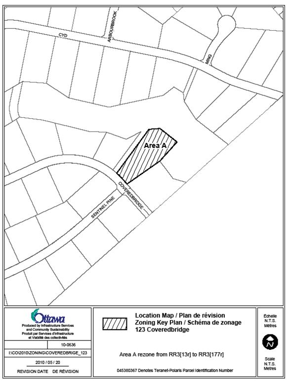
1: 123 Coveredbridge
Column 2: This existing vacant lot in the subdivision
was assigned exception 13r to reduce the lot area, however it is a large lot which meets the minimum lot area
requirements of the RR3 subzone and therefore does not need the reduction
contained in exception 13r. However, the lot width is smaller than the standard
60 metre minimum lot width requirement of the RR3 subzone, and therefore should
have been assigned exception 177r which reduces minimum lot width to 40 metres.
Column 3: Amend the Zoning Map, to rezone the subject lands,
as shown on Document 2, from RR3[13r] to RR3[177r].
b. Add
the attached Zoning Map to Document 2, and;
c. That
there be no further notice pursuant to Section 34 (17) of the Planning Act.
3. That Item 17 of Document 2, relating to 4497 O’Keefe Court,
be deferred to the next Agriculture and Rural Affairs Committee meeting dealing
with the correction of anomalies to By-Law 2008-250.
RECOMMANDATIONS
MODIFIÉES DU COMITÉ
Que le Conseil approuve :
1. les
modifications recommandées dans la colonne 3 du document 1 afin de corriger des
anomalies dans le Règlement de zonage no 2008-250;
2. l'ajout de la nouvelle rangée 18 qui
suit dans le document 1 :
a. Colonne
1 : 123, voie Coveredbridge
Colonne 2 : Ce lot vacant dans le lotissement a été
affecté de l'exception 13r à des fins de réduction de superficie; il s'agit
cependant d'un grand lot qui satisfait aux exigences minimales de superficie de
la sous-zone RR3 et ne nécessite donc pas la réduction prévue par l'exception
13r. La largeur du lot est toutefois inférieure à l'exigence minimale de 60
mètres de la sous-zone RR3 et le lot aurait donc dû être affecté de l'exception
177r, qui réduit la largeur minimale de lot à 40 mètres.
Colonne 3 : Modifier la carte
de zonage, afin de changer de RR3[13r] à RR3[177r] le zonage du terrain en
question, tels que le montre le le document 2;
b. l'ajout de la carte de zonage au
document 2;
c. la non-publication d'un autre avis
en vertu du paragraphe 34(17) de la Loi
sur l'aménagement du territoire;
3. le
report du point 17 du document 2, qui vise le 4497, cour O'Keefe, à la
prochaine réunion du Comité de l'agriculture et des affaires rurales portant
sur la correction des anomalies du Règlement de zonage 2008-250.
Documentation
1. Deputy City Manager’s Report, Infrastructure
Services and Community Sustainability dated 13 May 2010 (ACS2010-ICS-PGM-0097).
2. Extract
of Draft Minutes, Agriculture and Rural Affairs Committee, 27 May 2010.
Report to/Rapport au :
Agriculture and Rural Affairs Committee
Comité de l'agriculture et des affaires rurales
and Council / et au Conseil
Submitted by/Soumis par : Nancy Schepers, Deputy City
Manager,
Directrice
municipale adjointe, Infrastructure Services and Community Sustainability, Services
d’infrastructure et Viabilité des collectivités
Contact Person/Personne-ressource : Richard Kilstrom, Manager/Gestionnaire, Policy Development and Urban Design/Élaboration de la politique et conception urbaine, Planning and Growth Management/Urbanisme et Gestion de la croissance Élaboration de la politique et conception urbaine
(613)
580-2424 x22653, Richard.Kilstrom@ottawa.ca
REPORT RECOMMENDATION
That the Agriculture and Rural Affairs Committee recommend Council
approve the amendments recommended in Column 3 of Document 1, to correct
anomalies in Zoning By-law 2008-250.
RECOMMANDATION DU RAPPORT
Que le Comité de
l’agriculture et des affaires rurales recommande au Conseil d’approuver les
modifications recommandées dans la colonne 3 du document 1 afin de corriger des
anomalies dans le Règlement de zonage no 2008-250.
BACKGROUND
On June 25, 2008 City Council adopted the new Comprehensive Zoning By-law 2008-250 that affects all properties within Ottawa. By-law 2008-250 replaces the 36 Zoning By-laws of the former municipalities that were amalgamated in 2001. Since the adoption of the Zoning By-law, staff has been identifying anomalies that require correction, and reports to correct the anomalies are being forwarded to Committee and Council on a regular basis. This report details recommended amendments to correct a number of the identified anomalies in the rural area of the city.
DISCUSSION
Since the adoption of the Zoning By-law 2008-250, staff has monitored the new by-law and has identified certain anomalies that are being recommended for correction. Document 1 provides staff recommendations to Agriculture and Rural Affairs Committee on the anomalies in the rural area. Document 2 contains the maps showing the location of zoning map corrections.
The amendments are intended to correct mapping and text reference errors in the implementation of Council-approved changes that were not accurately reflected in the Comprehensive Zoning By-law.
RURAL IMPLICATIONS
The recommendations in the report correct anomalies in the rural area.
CONSULTATION
Notice of the public meeting to deal with these anomalies and corrections was provided in The Citizen and Le Droit, with a listing of the addresses and provisions subject to correction. As well, interested parties have been notified by individual mail.
COMMENTS BY THE WARD
COUNCILLOR(S)
N/A
LEGAL/RISK MANAGEMENT IMPLICATIONS
These changes are of a routine nature to correct anomalies and do not have any legal/risk management implications.
CITY STRATEGIC PLAN
N/A
TECHNICAL IMPLICATIONS
N/A
FINANCIAL IMPLICATIONS
There are no direct financial implications associated with this report.
SUPPORTING DOCUMENTATION
Document 1 List of Anomalies and Modifications to Zoning By-law 2008-250 for consideration by Agricultural and Rural Affairs Committee
Document 2 Location
Maps
DISPOSITION
Planning and Growth Management Department to prepare the implementing by-law and forward it to Legal Services who will then forward the by-law to City Council.
DOCUMENT 1
AS AMENDED (AT NO. 18)
LIST OF ANOMALIES AND MODIFICATIONS TO ZONING
BY-LAW 2008-250 FOR CONSIDERATION BY
AGRICULTURAL AND RURAL AFFAIRS COMMITTEE
|
Item |
Objective of Amendment |
Proposed Amendment |
|
Zoning Map Corrections |
||
|
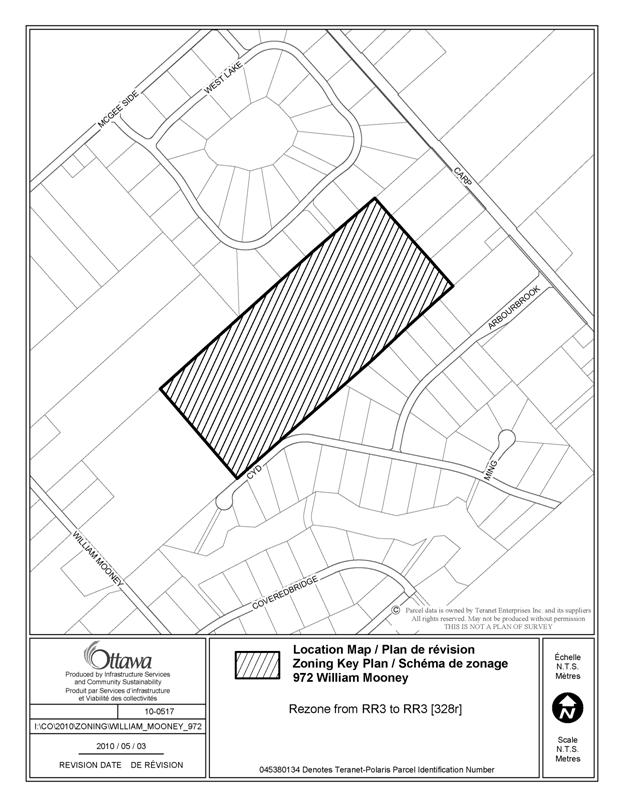
1. Part of 972
William Mooney Road Ward 5 |
As part of the appeals resolution process to By-law
2008-250, a zoning amendment was approved by the Ontario Municipal Board on
May 20, 2009 which created exception 328r to allow for a minimum interior
side yard of 4 metres on the property. Subsequently, an application for rezoning of these lands to
RR3 was approved by City Council in November 2009, with the standard minimum
requirement of 5 metres for the interior side yard. In order to be consistent with the OMB decision, it is
recommended that the reduced minimum side yard of 4 metres be carried over in
the RR3 zone for the lands. |
Amend the Zoning Map, to
rezone the subject lands, as shown on Document 2, from RR3 to RR3[328r]. |
|
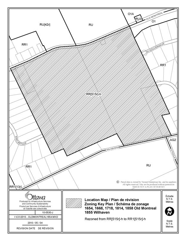
2. 1654, 1668, 1718, 1814, 1858 Old Montreal
Road, 1855 Wilhaven Drive Ward 19 |
The lands should be zoned the RR subzone 1, exception
[515r]-h, to reflect the former Cumberland ER zone which required 45 m lot
width. |
Amend the Zoning Map, to
rezone the subject lands, as shown on Document 2, from RR[515r]-h to
RR1[515r]-h. |
|
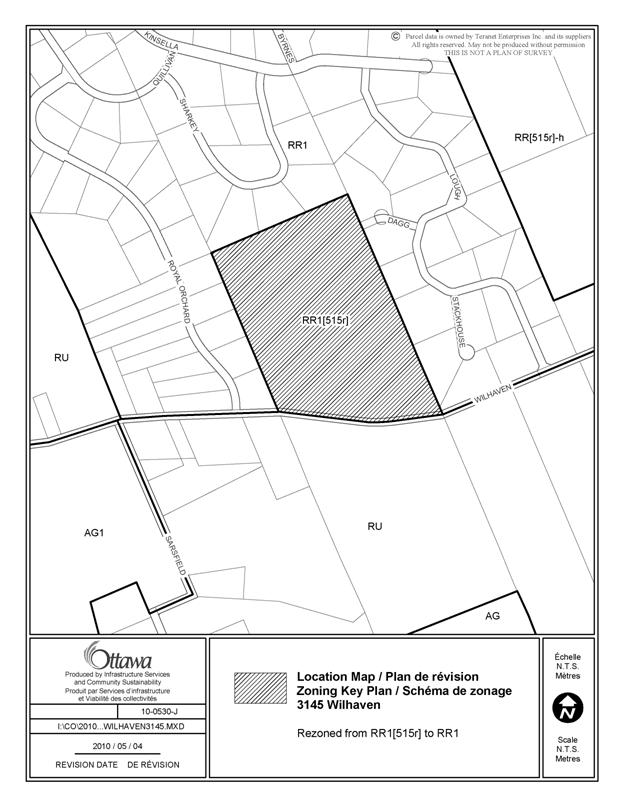
3. 3145 Wilhaven Drive Ward 19 |
These lands have been rezoned under the former Cumberland
Zoning By-law to remove the holding provisions, but this is not reflected in
By-law 2008-250, which would require
removal of the holding conditions contained in exception 515r . |
Amend the Zoning Map, to
rezone the subject lands, as shown on Document 2, from RR1[515r] to RR1. |
|
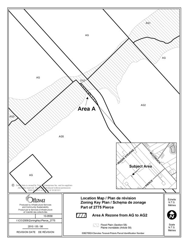
4. Part of 2775 Pierce Road Ward 21 |
This sliver of land zoned AG is part of 2775 Pierce Road
and should be the same zoning designation, which is AG2. |
Amend the Zoning Map, to
rezone the subject lands, as shown on Document 2, from AG to AG2. |
|
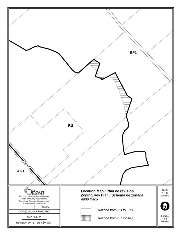
5. Part of 4900 Carp Road Ward 5 |
The lands located in the Carp Hills were acquired by the
City in 2008 for Natural Environment Area purposes and the zoning line
between the RU and EP3 designations should more accurately match the property
boundaries. |
Amend the Zoning Map, to
rezone the subject lands, as shown on Document 2, from RU to EP3 and EP3 to
RU. |
|
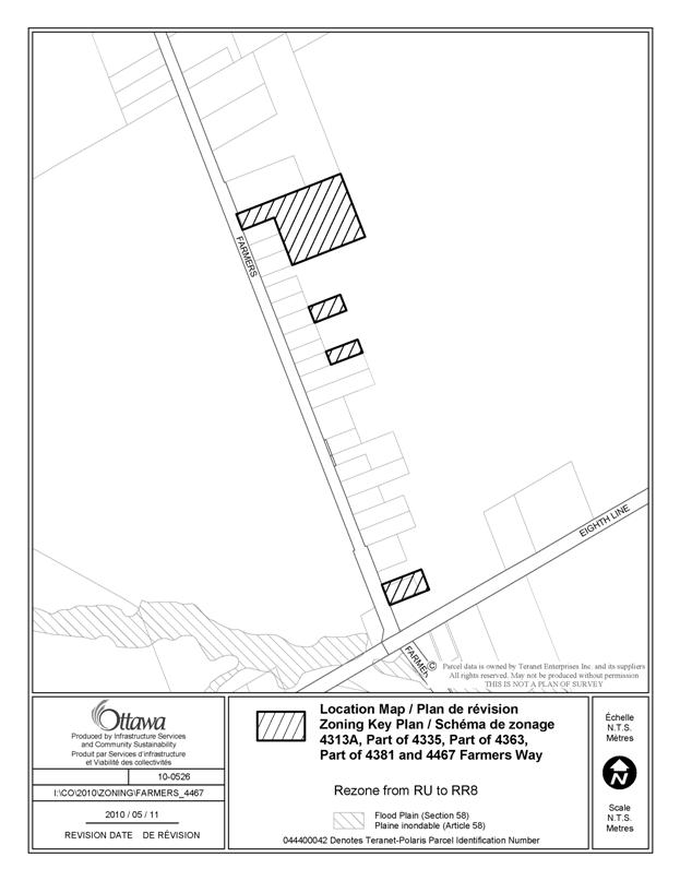
6. 4313A, Part of 4335,
Part of 4363, Part of 4381 and 4467
Farmers Way Ward 19 |
By-law 2005-309 rezoned these lands under the former
Gloucester Zoning By-law from Ag to Re1, however the changes were not
incorporated into By-law 2005-250. The lands are zoned RU and should be zoned
RR8 to reflect the former Gloucester Re1 zone. |
Amend the Zoning Map, to
rezone the subject lands, as shown on Document 2, from RU to RR8. |
|
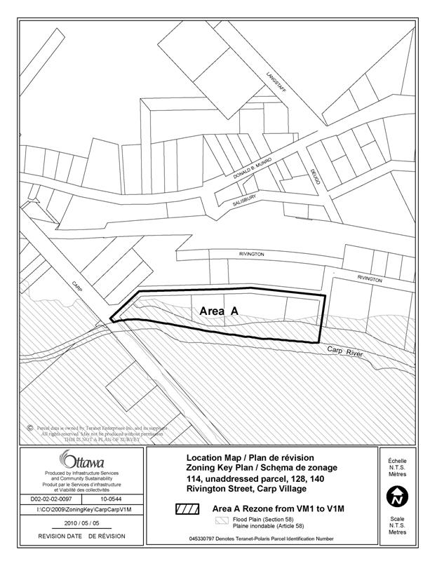
7. 114, unaddressed parcel,
128, 140 Rivington Street, Carp Village Ward 5 |
A typographical error on the zoning map resulted in these
lands being zoned VM1- Village Mixed-use subzone 1, rather than V1M – Village
Residential First Density subzone 1.
These lands are designated Residential in the Village of Carp
Community Design Plan. |
Amend the Zoning Map by rezoning the subject lands from VM1
to V1M, as shown on Document 2. |
|
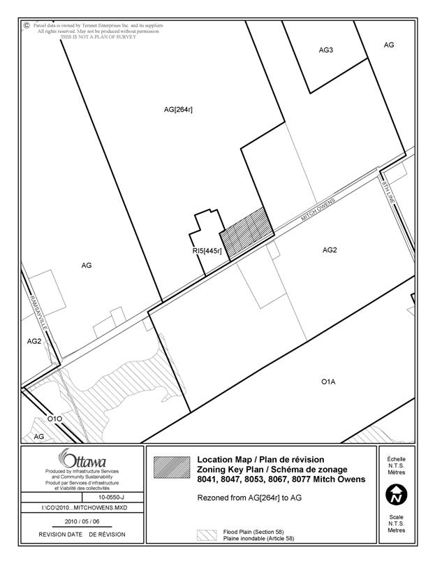
8. 8041, 8047, 8053, 8067
and 8077 Mitch Owens Road Ward 20 |
These lands are occupied by detached dwellings, however
they were inadvertently included in a change in the proposed draft
Comprehensive Zoning By-law modification to the lands to the north which
permit a military and police training facility through exception 264r. |
Amend the Zoning Map, to rezone the subject lands, as shown
on Document 2 from AG[264r] to AG. |
|
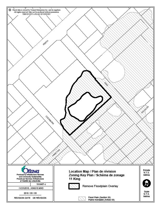
9. 11 King Street, Richmond Ward 21 |
The
floodplain overlay zoning on this site was based on the floodplain mapping of
the Jock River prepared by the Rideau Valley Conservation Authority, dated July
21, 2005. In February 2009, an application was submitted to the Rideau Valley
Conservation Authority for approval to re-grade the property with existing
stockpiled fill material on the site. This application (RV5-04/09) was
approved April 6, 2009 and the work was undertaken. An as-built elevation
survey dated September 14, 2009, prepared by M. Savic of Novatech Engineering
Consultants Ltd., was submitted following the work and the new grades have
shown the property to be above the 1:100 year floodplain of the Jock River.
On March 11, 2010, the Rideau Valley Conservation Authority revised the
mapping of the subject property to remove it from the floodplain designation.
|
Amend the Zoning Map, to rezone the subject lands, as shown
on Document 2, to remove the floodplain overlay. |
Zoning Map and Text
Corrections
|
||
|
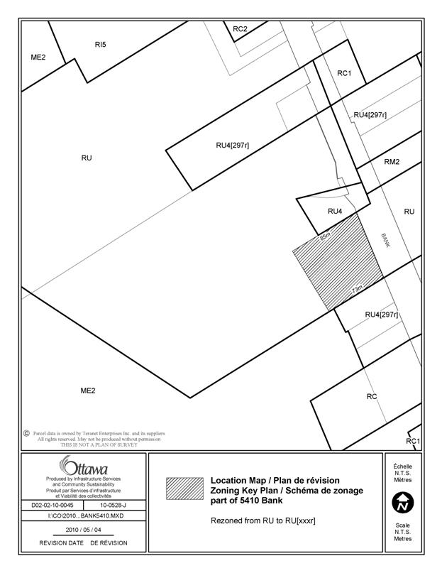
10. Part of 5410 Bank Street Ward 20 |
Amend Section 240, to
create an exception to add a retail store, limited to the sale of automotive
parts, as an additional land use
permitted, for the property shown in Document 2. |
|
|
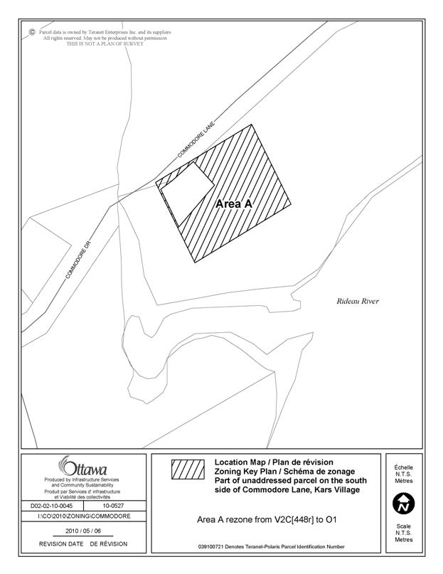
11. Part of unaddressed parcel on the south
side of Commodore Lane, Kars Village Ward 21 |
The wording of exception
[448r] does not accurately reflect the intent of a site-specific Zoning
By-law amendment approved in 2005. In addition, a refinement of the zoning
boundaries is required as the current boundaries of this exception zone are
not as shown in the 2005 Zoning By-law amendment. The area of land subject to the V2C [448r]
zone should be approximately 866 square metres, according to the survey
submitted by the applicant in 2005. As
geo-referenced mapping information is now available, the correct boundaries
of the exception zone can be located with a higher degree of accuracy. It should be noted that
while land use is regulated under the Planning
Act, development in a flood plain is
also regulated under the Conservation Authorities Act. A
permit from the Conservation Authority is required before a building permit
from the municipality may be issued under the Building Code Act. |
Amend exception [448r] by adding the provision, “-Despite the provisions in Section 58 – Flood Plain Hazard Overlay, a
detached dwelling is permitted.” Amend the boundaries of the V2C [448r] zone, as shown in
Document 2. The revised boundaries
will result in a portion of the V2C [448r] zone with flood plain overlay
being rezoned to O1 with flood plain overlay. |
|
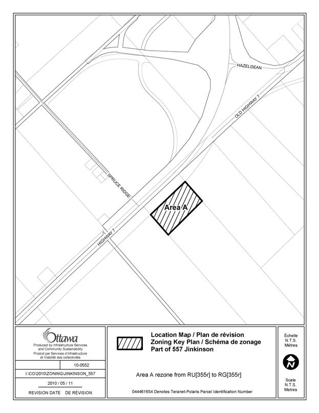
12. Part of 557 Jinkinson
Road/ 7120 Highway 7 Ward 21 |
A site specific amendment,
By-law 2006-445, rezoned the lands under the former Township of Goulbourn
Zoning By-law 40-99, from RU to MR-1-h, a rural industrial zone only
permitting a warehouse, mini-warehouse and storage with a holding zone. In
transferring this amendment to By-law 2008-250, an RU zone was utilized,
instead of the RG, Rural Industrial zone. As well, it was intended that all
uses be prohibited except for a “warehouse”, however, the exception was
prepared adding warehouse as an additional use. The holding provision was
lifted through By-law 2009-17. |
Amend the Zoning Map , to rezone the subject lands, as shown on Document 2, from
RU[355r] to RG[355r]. Amend Section
240, Exception 355r by including the words
“all uses except warehouse” under Column IV and deleting the word
“warehouse” in Column III. |
|
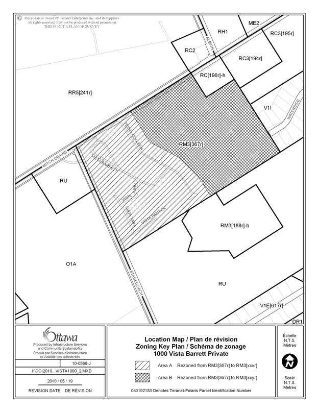
13. 1000 Vista Barrett
Private and part of 1121 Stagecoach Road Ward 20 |
The RM3 – Mobile Home Park
subzone 3 does not adequately reflect the provisions of the former Osgoode
MHP2, MHP4 and MHP4h mobile home park subzones regarding yard setbacks, maximum building height and maximum number
of dwelling units. |
Amend the RM3 subzone provisions in Table 168 (g) by adding, “5”, for
the maximum building height in metres. In Table 168, row (i) regarding the RM3 subzone provision
for maximum number of mobile home sites in mobile home park, delete the
number 110 and replace it with, “varies1”. Add a new
Table 168A – Additional Zoning Provisions to include a provision for endnote
1 stating, “As per exception.” Amend the zoning map to
rezone the subject lands from RM3[367r] to RM3[xxxr] and RM3[xxyr], as shown
in Document 2. Create and apply exception RM3[xxxr] to the land shown as
Area A in Document 2 with the following: Additional Land Uses Permitted: - detached dwelling Provisions: -maximum number of dwelling units is 136 Create and apply exception RM3[xxyr] to the land shown as
Area B in Document 2 with the following: Additional Land Uses Permitted: - detached dwelling Provisions: - minimum corner side yard setback is 15 metres- - minimum interior
side yard setback is 15 metres - minimum rear yard setback is 15 metres - maximum number of dwelling units is 167 Amend exception [367r], Column II by deleting the reference
to RM3[367r] Amend exception [188r] as follows: By moving the text “-detached dwelling” from Column II to Column III. by adding the following provisions: -minimum corner side yard set back is 15 metres - minimum interior side yard setback is 15 metres - minimum rear yard setback is 15 metres - maximum number of dwelling units is 167 |
|
Text
Corrections |
||
|
14. Exceptions 264r, 286r
and 445r |
There is an RC10 and AG
zone not listed in Column II of exception 264r. There is an AG3 zone not
listed in Column II of exception 286r Exception 445r permits a
“military training facility” and the terminology was changed to “military and
police training facility”. A correction should be made to use the consistent
terminology for this use. |
Amend Section 240, Column
II to: -
add
“RC10[264r]” and “AG[264r]” to exception 264r -
add
“AG3[286r] to exception 286r Amend Section 240, Column
III of exception 445r, to insert the words “and police” after the word
“military” |
|
15. 4980 Albion Road Ward 20 |
During City Council’s
consideration of the draft Comprehensive Zoning By-law on April 23, 2008, a
motion was passed (Motion No. 35/5 – item #4) which made two modifications to
exception 529r affecting the lands of the Central Canada Exhibition Association.
One of those modifications was not put into effect in the adopted text and
should be corrected to properly reflect the approved motion. The former
Gloucester zoning for these lands permitted banquet facilities and meeting
rooms in addtion to an exhibition facility and amphitheatre, therefore the
permitted place of assembly use should not be “limited to an amphitheatre”
and the motion recommeded the deletion of these words. Some minor changes are also
proposed to make reference to the permitted uses of the RC zone rather than
the RC4 suzone(subzone which does not identify uses, but rather provisions)
in Column IV. As well, two provisions regarding setbacks that were in the
former Gloucester Cr12 zone should have been carried over into exception 529r. |
Amend Section 240,
Exception 529r to: - delete the “4” after “RC”
and to add the word “permitted” before the first instance of the word “uses”
in Column IV - delete the words “limited
to an amphitheatre,” in Column V - add the following
provisions in Column V: - amusement park rides must be 150 m from any
lot line abutting a residential zone - a minimum 15 m landscape
area must be provided along any lot line abutting a residential zone |
|
16. 4564 Fallowfield Road Ward 21 |
The wording of exception
[74r] requires clarification in order to adequately implement the intent of
RMC Block “G” zone in the former Rural Nepean Zoning By-law. |
Amend
Section 240, exception [74r], by adding, “- restaurant” to Column IV and by
deleting the provisions contained in Column V. |
|
|
|
|
|
18. 123 Coveredbridge |
This
existing vacant lot in the subdivision was assigned exception 13r to reduce
the lot area, however it is a large
lot which meets the minimum lot area requirements of the RR3 subzone and
therefore does not need the reduction contained in exception 13r. However,
the lot width is smaller than the standard 60 metre minimum lot width
requirement of the RR3 subzone, and therefore should have been assigned
exception 177r which reduces minimum lot width to 40 metres. |
Amend
the Zoning Map, to rezone the subject lands, as shown on Document 2, from
RR3[13r] to RR3[177r]. |
LIST OF SITE-SPECIFIC
LOCATION MAPS DOCUMENT 2 AS AMENDED
|
Location Maps (attached) |
|
Part of 972 William Mooney Road |
|
1654, 1668, 1718, 1814,
1858 Old Montreal Road, 1855 Wilhaven Drive |
|
3145 Wilhaven Drive |
|
Part of 2775 Pierce Road |
|
4900 Carp Road |
|
4313A, Part of 4335, Part
of 4363, Part of 4381 and 4467 Farmers
Way |
|
114, unaddressed parcel,
128, 140 Rivington Street, Carp Village |
|
8041, 8047, 8053, 8067 and
8077 Mitch Owens Road |
|
11 King Street |
|
Part of 5410 Bank Street |
|
Part of unaddressed parcel
on the south side of Commodore Lane |
|
Part of 557 Jinkinson Road
/7120 Highway 7 |
|
1000 Vista Barrett Private and part of 1121 Stagecoach Road |
|
123
Coveredbridge |
AMENDED PAGE
(ADDITIONAL MAP RE: 123 COVEREDBRIDGE)