|
4. ZONING - 277 DONALD B. MUNRO DRIVE AND 185 SALISBURY
STREET ZONAGE - 277, PROMENADE
DONALD B. MUNRO ET 185, RUE SALISBURY |
COMMITTEE RECOMMENDATIONS
That Council
approve:
1. An
amendment to the Zoning By-law 2008-250 to change the zoning of:
i. 277
Donald B. Munro Drive from Development Reserve Subzone 1 (DR1) and Village
Residential Third Density Subzone B (V3B) to Village Residential First Density
Subzone N with an Exception (V1N[XXXr]), Village Residential Third Density
Subzone B with an Exception (V3B[XXYr]), i. Village Residential Third Density Subzone B
with an Exception (V3B[XXZr]) and Parks and Open Space (O1); and,
ii. 185
Salisbury Street from Village Residential Third Density subzone B (V3B) to
Parks and Open Space (O1);
as shown in Document 1 and detailed in Document
2.
2. An amendment to the Community Design
Plan for the Village of Carp to change:
i. the land use designation in Schedule A of the Community
Design Plan for part of 277 Donald B. Munro Drive from Residential - One and Two Unit Dwellings to Residential-Ground Oriented Multi Unit;
ii. the location of the neighbourhood park
as set out in Schedule A; and,
iii. the text of Policy 1 in subsection 3.8
describing the location of the neighbourhood park;
as detailed
in Document 3 and shown in Document 4.
RECOMMANDATIONS
DU COMITÉ
Que le Conseil
approuve :
1. Une modification au Règlement de zonage
2008-250 visant à faire passer le zonage du :
i. 277, promenade Donald B. Munro de
sous-zone d'aménagement futur 1 (DR1) et sous-zone résidentielle de village de
densité 3 B (V3B) à sous-zone résidentielle de village de densité 1 N assortie
d'une exception (V1N[XXXr]), sous-zone résidentielle de village de densité 3 B
assortie d'une exception (V3B[XXYr]), sous-zone résidentielle de village de densité 3 assortie d’une exception
(V3B[XXZr]) et zone de parc et d’espace vert (O1);
ii. 185, rue Salisbury de sous-zone
résidentielle de village de densité 3 B (V3B) à zone de parc et d’espace vert
(O1);
tel qu’illustré dans
le Document 1 et exposé en détail dans le Document 2.
2. Une
modification au Plan de conception communautaire du village de Carp visant ce
qui suit :
i. Faire
passer la désignation d’utilisation du sol de l’annexe A du Plan de conception
communautaire et concernant une partie du 277, promenade Donald B. Munro de
Résidentiel - logements d’une et deux unités à
Résidentiel - unités multiples en rez-de-chaussée;
ii. Modifier l’emplacement du parc de quartier tel qu’expliqué à
l’annexe A;
iii. Modifier le texte de la politique 1 du paragraphe 3.8 décrivant
l’emplacement du parc de quartier;
tel qu’exposé en
détail dans le Document 3 et
illustré dans le Document 4.
Documentation
1. Deputy City Manager’s Report, Infrastructure
Services and Community Sustainability dated 12 May 2010 (ACS2010-ICS-PGM-0093).
Report to/Rapport au :
Agriculture
and Rural Affairs Committee
Comité
d'agriculture et des affaires rurales
and Council / et au Conseil
Submitted by/Soumis par :
Nancy Schepers, Deputy City Manager/Directrice
municipale adjointe, Infrastructure Services and Community
Sustainability/Services d’infrastructure et Viabilité des collectivités
Contact Person/Personne-ressource
: Derrick Moodie, Manager/Gestionnaire, Development Review-Rural
Services/Examen des projets d'aménagement-Services ruraux, Planning and Growth
Management/Urbanisme et Gestion de la croissance
(613)
580-2424, 15134 Derrick.Moodie@ottawa.ca
|
SUBJECT: |
ZONING
- 277 Donald B. Munro Drive |
|
|
|
|
OBJET : |
ZONAGE - 277, promenade donald b. munro |
REPORT RECOMMENDATIONS
That the Agriculture and Rural
Affairs Committee recommend Council approve:
1. An
amendment to the Zoning By-law 2008-250 to change the zoning of:
i. 277 Donald
B. Munro Drive from Development Reserve Subzone 1 (DR1) and Village Residential
Third Density Subzone B (V3B) to Village Residential First Density Subzone N
with an Exception (V1N[XXXr]), Village Residential Third Density Subzone B with
an Exception (V3B[XXYr]), i. Village Residential Third Density
Subzone B with an Exception (V3B[XXZr]) and Parks and Open Space (O1); and,
ii. 185
Salisbury Street from Village Residential Third Density subzone B (V3B) to
Parks and Open Space (O1);
as shown in Document 1 and detailed in Document 2.
2. Approve an amendment to the Community Design
Plan for the Village of Carp to change:
i. the
land use designation in Schedule A of the Community Design Plan for part of 277
Donald B. Munro Drive from Residential - One and
Two Unit Dwellings to Residential-Ground
Oriented Multi Unit;
ii. the location of the neighbourhood park as set
out in Schedule A; and,
iii. the text of Policy 1 in subsection 3.8
describing the location of the neighbourhood park;
as detailed
in Document 3 and shown in Document 4.
RECOMMANDATIONS
DU RAPPORT
Que le Comité de l’agriculture
et des affaires rurales recommande au Conseil d’approuver ce qui suit :
1. Une modification au Règlement de zonage 2008-250
visant à faire passer le zonage du :
i. 277,
promenade Donald B. Munro de sous-zone d'aménagement futur 1 (DR1) et sous-zone
résidentielle de village de densité 3 B (V3B) à sous-zone résidentielle de
village de densité 1 N assortie d'une exception (V1N[XXXr]), sous-zone
résidentielle de village de densité 3 B assortie d'une exception (V3B[XXYr]), sous-zone
résidentielle de village de densité 3 assortie
d’une exception (V3B[XXZr]) et zone de parc et d’espace vert (O1);
ii. 185, rue Salisbury de sous-zone résidentielle
de village de densité 3 B (V3B) à zone de parc et d’espace vert (O1);
tel qu’illustré
dans le Document 1 et exposé en détail dans le Document 2.
2. Une
modification au Plan de conception communautaire du village de Carp visant ce
qui suit :
i. Faire passer la désignation
d’utilisation du sol de l’annexe A du Plan de conception communautaire et
concernant une partie du 277, promenade Donald B. Munro de Résidentiel - logements d’une et deux unités à Résidentiel -
unités multiples en rez-de-chaussée;
ii. Modifier
l’emplacement du parc de quartier tel qu’expliqué à l’annexe A;
iii. Modifier le
texte de la politique 1 du paragraphe 3.8 décrivant l’emplacement du parc de
quartier;
tel qu’exposé en
détail dans le Document 3 et
illustré dans le Document 4.
BACKGROUND
The subject site is
located at 277 Donald B. Munro Drive within the Village of Carp. The site is approximately 7.7 hectares in
size, is currently vacant and used for livestock pasture. Fronting on the south side of Donald B.
Munro, the main southeast entrance to the Village, the lands are bounded by a
railway corridor to the south (Renfrew Spur Line) and residential to the west. The eastern limits of the site coincide with
the Village boundary. Lands east of the
boundary are rural residential, fallow farmland and a pine plantation forest.
On December 6, 2007, the Owner filed concurrently, Plan of Subdivision and Zoning By-law Amendment applications. The plan of subdivision was draft approved on December 16, 2009 for 45 single detached residential lots, eleven residential blocks (semi-detached units) and four residential blocks (townhouse units). A condition of final approval requires the Owner, prior to registration of the Plan, to ensure that the proposed plan conforms with a Zoning By-law approved under the requirements of the Planning Act.
Purpose of Zoning Amendment
This is an application to rezone:
i) 277 Donald B. Munro Drive from Development Reserve Subzone 1 (DR1) and Village Residential Third Density Subzone B (V3B) to Village Residential First Density Subzone N with an Exception, (V1N[XXXr]), Village Residential Third Density Subzone B with an Exception (V3B[XXYr]), Village Residential Third Density Subzone B with an Exception (V3B[XXZr] and Parks and Open Space (O1); and,
ii) 185 Salisbury Street from Village Residential Third Density (V3B) to Parks and Open Space (O1);
in order to facilitate development of the approved draft plan of subdivision.
The properties are currently zoned Development
Reserve Subzone 1 (DR1) and Village Residential Third Density Subzone B (V3B) pursuant to By-law 2008-250. The DR1 zone is intended to recognize future
village development areas and limit land uses to those that would not preclude
development. The Village Third Density Subzone B Zone permits a range of low
and medium density housing types such as detached, semi-detached and multiple
attached dwelling units.
As a result of the approved plan of
subdivision, the lands will be rezoned to appropriate zones to permit
development.
- It is proposed to rezone the lands fronting onto Donald B. Munro Drive and the lands central to the internal road network to Village Residential First Density subzone N with an Exception (V1N[XXXr]) to permit single detached units. The exception to the V1N zone will recognize a reduced lot width and lot area.
- The lands around the perimeter of the site will be separated into two Village Residential Third Density subzone B zones. In order to accommodate the specific location of unit types as defined by the approved plan of subdivsion the first zone, Village Residential Third Density subzone B with an Exception(V3B[XXYr]) will accommodate a mix of semi-detached and multiple ground oriented units as per the plan of subdivision. While the second zone, Village Residential Third Density subzone B Exception (V3B[XXZr]), will provide for similar provisions, it will, however, prohibit multiple attached dwellings. Further provisions will be added to the exceptions of both zones to recognize a reduction in the interior and corner side yard setbacks and an increased lot coverge.
- All of the new exceptions to the V1N and V3B zones will include provisions to ensure that the maximum distance a private garage may extend beyond the front wall is 1 metre closer to the street and the maximum width of a private garage accessory to the liveable portion whether attached or detached, is 50 per cent of the width of the lot occupied by the dwelling unit.
- A park block and stormwater management pond, as conditioned by the plan of subdivision, will be zoned as Parks and Open Space (O1).
The details of the zone provisions can be found in Document 2.
Amendment to the Village Community Design Plan
The
CDP for the Village of Carp was approved by City Council on July 14, 2004, as a
policy document, to guide the long-term growth and development of Carp. Where a significant change to the land use
policies of the Community Design Plan is requested, an amendment to the
Community Design Plan must be approved by Council. Unlike an amendment to the Official Plan,
amending the CDP can be undertaken through the Zoning By-law amendment process.
In order to accommodate the unit mix as per the draft approved plan of subdivision an amendment to Schedule A – Land Use of the Village of Carp CDP is required to change the land use designation from “Residential – One and Two Unit Dwellings” to “Residential – Ground Oriented Multi-Unit”.
In addition, an amendment to Section 3.8 and Schedule A Land Use is required to accommodate the relocation of the park.
Currently Section 3.8 Neighbourhood Park states:
- “The Neighbourhood Park is designated as a symbol on Schedule
A. The park will front on Donald B
Munro Drive, be approximately one hectare in size with street frontage on
at least two sides. The precise
configuration of the park site will be determined during the development
process.”
Policy 1 of Subsection 3.8 will be amended by deleting it in its entirety and replacing it with the following:
“1. The Neighbourhood Park is designated as a symbol on Schedule A. The precise configuration of the park site will be determined during the development approval process.”
Further, Schedule A – Land Use will be amended by deleting the existing star symbol and adding a new star symbol to Schedule A – Land Use, as shown in Document 4.
The details of the above amendments can be found in Documents 3 and 4.
DISCUSSION
The Zoning By-law amendment application was filed concurrently with the Plan of Subdivision. The lands that are subject to this application are within the “Village” designation as identified on Schedule ‘A’, Rural Policy Plan of Official Plan. The intensity and distribution of land uses within Villages are determined in the context of a community design plan, where such a plan has been undertaken.
On
July 14, 2004 City Council approved a Community Design Plan (CDP) for the
Village of Carp. The CDP provides
guidelines for the day-to-day decision-making on land use planning, such as subdivision, zoning and site plan
applications, and it sets the community’s priorities for the future. More specifically the CDP sets aside the
subject lands for residential use.
Aside from the broader land use policies of
the CDP, there were a number of objectives and initiatives identified in the
CDP that were site-specific to the subject lands and dealt with through the
approved plan of subdivision. There were
two site-specific policies where the draft approved plan departed slightly from
the direction of the CDP that also need to be addressed in the Zoning By-law
amendment.
The first one was the introduction of
townhouse units (ground oriented multi-unit residential) to the unit mix. As a general policy of the CDP, there
is an objective to provide a wide range of housing types within the Village.
The CDP Schedule ‘A’ provides for a number of locations where multi-unit
development is desired. There are three
locations for multi-unit development identified in the easterly portion of the
Village. One of these sites (also owned
by the applicant) is located adjacent to his current proposal on the extreme
southeast corner on the opposite side of the railway line. Subsequent to the
preparation and approval of the CDP, it was determined through detailed analysis
that these lands had significant development constraints due to the flood plain
of the Carp River. As such, these lands
are no longer available for multi-unit development as identified in the CDP. That said, the request to introduce,
multi-unit (ground oriented townhouse units) development through the plan of
subdivision was considered as net neutral and did not impact what was
originally envisioned through the land use policies of the CDP.
The second change to the direction of the CDP
was the re-location of the neighbourhood park.
Schedule ‘A’ of the CDP
identifies the desired area for such a park to serve this community. Section 3.8.1 of the CDP gives further
direction as to the size and specific location of the park. During the consultation process with the
community, staff’s position on the size and the need to centrally locate the
park was based on the total development potential of lands to the north and
south of Donald B. Munro Drive. During
the review of the plan of subdivision it was determined that significant
development constraints with regard to sanitary servicing existed in the
southern portion of the lands. In an effort to achieve a gravity based servicing system
(and to obviate the need for extensive amount of fill), it was necessary to
locate the internal public road system a significant distance (50+ metres) from
the southern boundary. Having to design
around the development constraints impacted on the location of the park.
The plan of
subdivision relocates the park along the open space system (pathways) as
identified on Schedule ‘C’- Pedestrian Pathway System, CDP. Positioning the park along the open space system
not only allows for multiple access points but potential to serve the future
development of lands to the north and access for existing residential
development on Salisbury Street. As the park
itself is intended for passive use, its location nearer to complementary
facilities such as the open space system is considered more appropriate than
directly adjacent to Donald B. Munro Drive.
Both changes to the CDP policies were discussed at the public meeting for the plan of subdivision. Subsequently, the rationale provided in the Plan of Subdivision Delegated Authority Report was not disputed and the subdivision was draft approved on December 16, 2009 with all levels of appeal exhausted.
In
addition to the site specific policies of the CDP which direct the location of
land uses, Section 3.3.5 also
provides additional guidance for new residential development in the village to
ensure that new development reflects the characteristics of traditional village
or neighbourhood development rather than resembling suburban or country lot
estate development. The following is a brief summary of some of the relevant
guidelines:
·
Building
face-to-face distances should be in the range of 24-25 metres for smaller
singles, semi, duplexes and townhouses not greater than 30 metres for larger
singles.
·
Residential
streets are to be 18.0 metres wide in new subdivision plans. The proposed subdivision
contains 18.0-metre-wide streets.
·
The
front of garages should not extend beyond the front of facade of the house,
either as attached buildings or separate structures.
The proposed zoning that includes
Village Residential
First Density, Village Residential Third Density their subzones and exceptions,
and Park and Open Space is appropriate for the subject lands. The provisions take into account the changes
as approved through the Plan of Subdivision and respect the guidelines for new residential development in
the village.
Draft Approved Plan of Subdivision File #
D07-16-07-0029
ENVIRONMENTAL IMPLICATIONS
The subject site is located within the Village of Carp Well Head Protection Zone. Currently the City’s Zoning By-law does not regulate the uses on this site in terms of the protection policies. That said, residential uses on public water and waste water systems do not pose a threat on the groundwater resource areas.
RURAL IMPLICATIONS
The proposal is consistent with the documents in which guide the development of the Village of Carp. The proposed Zoning By-law amendment will have no adverse effects on the rural community.
CONSULTATION
Notice of this application was carried out in accordance with the City's Public Notification and Consultation Policy. Details of the consultation can be seen in Document 5.
COMMENTS BY THE WARD COUNCILLOR(S)
The Ward Councillor is aware of this application and the staff recommendation.
LEGAL/RISK MANAGEMENT IMPLICATIONS
There are no legal/risk management implications associated with this report.
CITY STRATEGIC PLAN
The recommended Zoning By-law amendment aligns with the City Strategic Plan by preserving rural villages and ensuring that decisions affecting rural communities are made with input from the rural residents.
TECHNICAL IMPLICATIONS
N/A
FINANCIAL IMPLICATIONS
There are no financial implications associated with this report.
APPLICATION PROCESS TIMELINE STATUS
The application was not processed by the "On Time Decision Date" established for the processing of Zoning By-law amendments due to the complexity of the issues associated with the review and approval of the plan of subdivision.
SUPPORTING DOCUMENTATION
Document 1 Location
Map
Document 2 Details of Recommended Zoning
Document 3 Details
of the Amendment to the Village of Carp CDP
Document 4 Village
of Carp CDP Schedule A
Document 5 Consultation Details
DISPOSITION
City Clerk and Solicitor Department, Legislative Services to notify the owner, applicant, OttawaScene.com, 174 Colonnade Road, Unit #33, Ottawa, ON K2E 7J5, Ghislain Lamarche, Program Manager, Assessment, Financial Services Branch (Mail Code: 26-76) of City Council’s decision.
Planning and Growth Management to prepare the implementing by-law, forward to Legal Services and undertake the statutory notification. Legal Services to forward the implementing by-law to City Council.
LOCATION MAP DOCUMENT
1
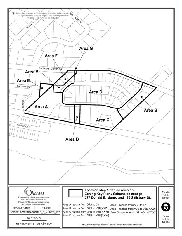
DETAILS OF RECOMMENDED ZONING DOCUMENT 2
Proposed
Changes to the Comprehensive Zoning By-law
The property
know municipally as 277 Donald B. Munro Drive, as shown on Document 1, will be
rezoned from DR1 to V1N[XXYXr],
V3B[XXY], V3B[XXZ] and O1.
The property known municipally as 185 Salisbury Street, as shown on Document 1, will be rezoned from V3B to O1.
A new Exception, V1N[XXXr], will be added to Section 240 and will include the following provisions:
· Minimum Lot Width: 15 m
· Minimum Lot Area: 530 m2
· No portion of a private garage or a carport may be located more than 1 metre closer to the street lot line facing the front of the principal building than the wall of that building. Maximum width of a private garage or carport: 50% of the width of the lot occupied by the dwelling unit.
A new Exception, V3B[XXYr], will be added to Section 240 and will include the following provisions:
· Minimum Interior Side Yard Setback: 2m
· Minimum Corner Side Yard Setback: 4.5 m
· Maximum Lot Coverage: 35%
· No portion of a private garage or a carport may be located more than 1 metre closer to the street lot line facing the front of the principal building than the wall of that building. Maximum width of a private garage or carport: 50% of the width of the lot occupied by the dwelling unit.
A new Exception, V3B[XXZr], will be added to Section 240 and will include the following:
Land Uses Prohibited:
· Multiple attached dwellings
Provisions:
· Minimum Interior Side Yard Setback: 2m
· Minimum Corner Side Yard Setback: 4.5 m
· Maximum Lot Coverage: 35%
· No portion of a private garage or a carport may be located more than 1 metre closer to the street lot line facing the front of the principal building than the wall of that building.Maximum width of a private garage or carport: 50% of the width of the lot occupied by the dwelling unit.
DOCUMENT 3
DETAIL OF CHANGES TO THE COMMUNITY
DESIGN PLAN
VILLAGE OF CARP
The following changes will be made
to the Community Design Plan for the Village of Carp: Schedule A–Land Use
1. Schedule A – Land Use will be amended by changing the land use designation for part of the lands known municipally as 277 Donald B. Munro Drive from “Residential – One and Two Unit Dwellings” to “Residential – Ground Oriented Multi-Unit” as shown in Document 4.
2. Policy 1 of Subsection 3.8 will be amended by deleting it in its entirety and replacing it with the following:
“1. The Neighbourhood Park is designated as a symbol on Schedule A. The precise configuration of the park site will be determined during the development approval process.”
3. Schedule A – Land Use will be amended by deleting the existing star symbol and adding a new star symbol to Schedule A – Land Use, as shown in Document 4.
VILLAGE OF CARP CDP SCHEDULE A DOCUMENT 4
DOCUMENT 5
CONSULTATION DETAILS
NOTIFICATION AND CONSULTATION PROCESS
Notification and public consultation was undertaken in accordance with the Public Notification and Public Consultation Policy approved by City Council for Zoning By-law amendments. The Zoning By-law Amendment was presented at the Public Meeting for the Plan of Subdivision which was held on March 4, 2008 at the Carp Agricultural Fairgrounds Society Hall, 3790 Carp Road, Carp, ON.
SUMMARY OF PUBLIC INPUT
Of the comments heard at the Public Meeting, many of the concerns raised were subdivision design related, such as noise, traffic, servicing capacity, stormwater management and the location of sidewalks. A number of questions were raised with regard to the addition of townhouse units and the re-location of the park. These issues were addressed through the Plan of Subdivision process and have also been detailed in this report.
COMMUNITY ORGANIZATION COMMENTS
No comments were received form the Community Associations
ADVISORY COMMITTEE COMMENTS
Comments received from the Ottawa Forest and Greenspace Advisory Committee were design- and environmentally-related and dealt with through the approval of the Plan of Subdivision.