Committee recommendationS
(This matter is
Subject to Bill 51)
That Council:
1.
Approve
and adopt an amendment to the Official Plan Volume 2A: Secondary Plans for the
Preston-Champagne Secondary Plan to re-designate 100 Champagne Avenue South
from “Residential Low Profile” to “Residential High Profile”, as detailed in
Document 2; and
2.
Approve an amendment to Zoning By-law 2008-250 to change the
zoning of 100 Champagne Avenue South from R4M (Residential Fourth Density
Subzone M) to R5P Sxxx (Residential Fifth Density Subzone P, Schedule
xxx) zone as detailed in Document 3, and shown
in Document 4.
RECOMMANDATIONS DU
COMITÉ
(Cette question est
assujettie au Règlement 51)
Que Conseil :
1.
approuve et adopte une modification au volume 2A du Plan officiel :
plans secondaires du Plan secondaire Preston-Champagne, afin de faire passer la
désignation du 100, avenue Champagne Sud d’utilisation « résidentielle à
profil bas » à utilisation « résidentielle à profil élevé », tel
qu’exposé en détail dans le document 2;
2.
approuver une modification au Règlement de zonage no 2008-250 afin de faire passer le zonage du 100, avenue Champagne Sud de R4M (zone résidentielle de densité 4, sous-zone M) à R5P Sxxx (zone résidentielle de densité 5, sous-zone P, annexe xxx), tel qu’exposé en détail dans
le document 3 et illustré dans le document 4;
Documentation
1. Deputy City Manager's report Infrastructure Services and Community
Sustainability dated 1 September 2010 (ACS2010-ICS-PGM-0162).
2. Extract of Draft Minutes of 14
September 2010.
Report
to/Rapport au :
Planning and Environment Committee
Comité de l'urbanisme
et de l'environnement
01 September 2010 / le 01 septembre 2010
Submitted by/Soumis
par : Nancy Schepers, Deputy City
Manager/Directrice municipale adjointe, Infrastructure Services and Community Sustainability, Services d'infrastructure et Viabilité des
collectivités
Contact Person/Personne-ressource : Richard Kilstrom,
Acting Manager/Gestionnaire intérimaire, Development Review-Urban Services,
Inner Core/Examen des projets d'aménagement-Services urbains, Unité du Centre
intérieur, Planning
and Growth Management/Urbanisme et Gestion de la croissance
(613) 580-2424, 22379 Richard.Kilstrom@ottawa.ca
|
|
Ref N°: ACS2010-ICS-PGM-0162
|
|
SUBJECT:
|
OFFICIAL
PLAN AMENDMENT AND ZONING - 100 CHAMPAGNE AVENUE SOUTH (FILE NO.
D01-01-10-0008; D02-02-10-0025)
|
|
|
|
|
OBJET :
|
MODIFICATION DU PLAN OFFICIEL ET ZONAGE -
100, AVENUE CHAMPAGNE SUD
|
REPORT RECOMMENDATIONS
That the Planning and Environment
Committee recommend that Council:
3.
Approve and adopt an amendment to the Official
Plan Volume 2A: Secondary Plans for the Preston-Champagne Secondary Plan to
re-designate 100 Champagne Avenue South from “Residential Low Profile” to “Residential
High Profile”, as detailed in Document 2; and
4.
Approve an amendment to Zoning By-law 2008-250 to change the
zoning of 100 Champagne Avenue South from R4M (Residential Fourth Density Subzone M)
to R5P Sxxx (Residential Fifth Density Subzone P, Schedule xxx) zone as detailed in Document 3,
and shown in Document 4.
RECOMMANDATIONS DU
RAPPORT
Que le Comité de l’urbanisme et de
l’environnement recommande ce qui suit au Conseil :
3.
Approuver et adopter une modification au volume 2A du Plan
officiel : plans secondaires du Plan secondaire Preston-Champagne, afin de
faire passer la désignation du 100, avenue Champagne Sud d’utilisation
« résidentielle à profil bas » à utilisation « résidentielle à
profil élevé », tel qu’exposé en détail dans le document 2;
4.
Approuver une modification au Règlement de zonage no 2008-250 afin de faire passer le zonage du 100, avenue Champagne Sud de R4M (zone résidentielle de densité 4, sous-zone M) à R5P Sxxx (zone résidentielle de densité 5, sous-zone P, annexe xxx), tel qu’exposé en détail dans
le document 3 et illustré dans le document 4;
BACKGROUND
Site Description
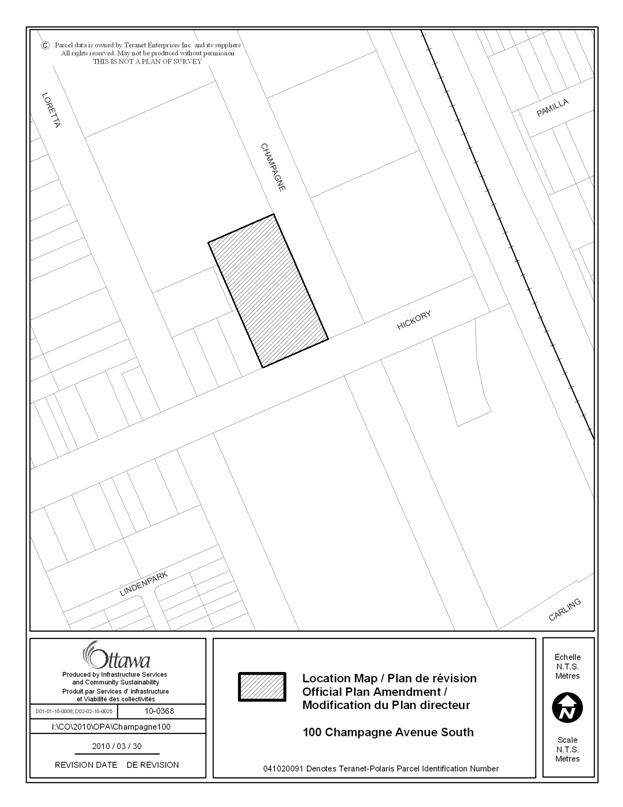
The subject site, 100 Champagne Avenue South, is located on the
northwest corner of Hickory Street and Champagne Avenue South. The 0.25-hectare site currently contains a
one-storey building. The site is
surrounded by a 14-storey residential apartment with surface parking to the
north, low-rise residential to the west, medium-rise office to the south, and
undeveloped lands intended for high-rise mixed use development to the east.
The site is currently designated as Mixed Use Centre on Schedule B of
the Official Plan, and as Residential Low Profile on Schedule L of the
Preston-Champagne Secondary Plan. The
site is zoned as R4M (Residential Fourth Density Subzone M) in Zoning By-law
2008-250.
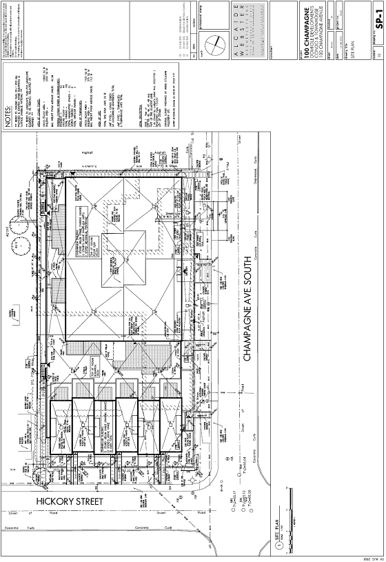
Proposal
The proposed development consists of a 12-storey high-rise apartment
dwelling with 94 units fronting onto Champagne Avenue South, and a three-storey
multiple attached (townhouse) dwelling with six units fronting directly onto
Hickory Street. The townhouse and
high-rise apartment dwellings are linked by a common parking garage with a
total of 109 spaces, including two car-sharing spaces (i.e. Vrtucar) and six
visitor spaces. Access to the parking is
proposed to be via Champagne Avenue South.
Amenity space will be provided above the podium between the townhouses
and the high-rise apartment, as well as on individual balconies. The 12-storey building will be set back an
additional two metres above the third storey.
The proposed site plan, submitted with the concurrent Site Plan
application, is shown in Document 5.
Purpose of
Applications
As the proposal does not conform to the existing Secondary Plan
designation or the existing zoning, an Official Plan Amendment and Zoning
By-law Amendment are required. The
purpose of the Official Plan Amendment is to amend the Preston-Champagne
Secondary Plan from Residential Low Profile to Residential High Profile. The purpose of the Zoning By-law Amendment is
to amend the zoning of the site from R4M (Residential Fourth Density Subzone M)
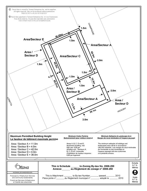
to R5P Sxxx (Residential Fifth Density Subzone P, Schedule xxx) with a maximum height of 42 metres. In addition, the proposed Zoning By-law
amendment includes the following reductions:
- Corner
side yard setback (Champagne): 0 metres
up to 11 metres height; three metres above 11 metres height;
- Interior
side yard setback (west): 1.9 metres for one-storey podium; 6.2 metres for
high-rise;
- Rear
yard setback (north): 1.5 metres;
- Visitor
parking: six spaces.
DISCUSSION
Planning Act and Provincial
Policy Statement
Section 2
of the Planning Act outlines those land use matters that are of
provincial interest, to which all City planning decisions shall have
regard. The provincial interests that
apply to this site include the appropriate location of growth and development
and the promotion of development that is designed to be sustainable to support
public transit and to be oriented to pedestrians. In addition, the Planning Act requires that all City planning decisions be
consistent with the Provincial Policy Statement (PPS), a document that provides
further policies on matters of provincial interest related to land use
development. PPS policies indicate that there should be an appropriate
mix of uses to support strong, liveable, and healthy communities.
The proposal allows for development of a
density that will efficiently use land and contribute to a balanced community. The
site is conveniently located near transit (Carling O-train station), and nearby
residential and commercial areas to allow for access by pedestrians and
transit. The site is located within one block of an arterial road (Carling
Avenue), which provides good access to the site and is a focus for existing
and future mixed-use development. Staff conclude that the proposal is
consistent with the matters of provincial interest as outlined in the Planning
Act and PPS.
Official Plan
Strategic
Directions
Section 2.3.1 of the
Official Plan sets broad strategic directions to meet the challenge of managing
growth, providing infrastructure, maintaining environmental integrity and
creating livable communities within Ottawa. To meet these challenges, polices
are set out to pursue a mix of land uses and compact forms of development which
in turn will enable the City to support a high-quality transit system and make
better use of existing infrastructure and roads. The proposed development will support this
overall goal.
Land Use Designations
The site is designated as “Mixed
Use Centre” on Schedule B of the Official Plan.
The Mixed-Use Centre designation permits a broad variety of uses and
encourages transit-supportive land uses with the goal of creating complete
neighbourhoods. These areas are intended
to include a broad range of land uses, such as offices, retail, schools,
hotels, hospitals, large institutional buildings, recreation and entertainment
facilities, entertainment uses, services, high and medium-density residential
uses, and mixed-use development. The
Mixed-Use Centre designation identifies areas that are strategically located
with respect to the transportation system and are accessible by transit,
walking, cycling and automobile. They
are centered on rapid transit stations and contain one or more arterial roads
with all-day frequent transit service.
Mixed-use centres are one of the target areas identified for
intensification. The Bayview-Preston
Mixed Use Centre has a minimum target density at 2031 of 285 people and jobs
per net hectare.
The proposed development has a
density of 669 people and jobs per net hectare, and thus meets the minimum
target density. It is located within 600
metres of the Carling O-train station, near arterial roads, and multi-use
pathways, which facilitate travel by all modes and encourages transit use. The proposal redevelops an underutilized site
in an area that is characterized by several properties in transition from
industrial uses to more intense development.
The proposed high-density residential use is specifically permitted in the
Mixed Use Centre designation, and fulfils the housing objectives through the
inclusion of multiple types of housing.
In light of the above, the proposed development is consistent with the
direction of this land use designation.
Preston-Champagne Secondary Plan
The Preston-Champagne Secondary
Plan in Volume 2 of the Official Plan seeks to reinforce the area as a diverse
inner city neighbourhood with a broad mix of uses. It will allow major redevelopment that
transitions to existing lower profile residential areas. The southwest quadrant, where the subject
site is located, will incorporate new office and residential development, which
will transition down in height when moving away from Carling Avenue. The plan also seeks to enhance Preston Street
as the main pedestrian-oriented shopping area and community focus. The “Residential Low Profile” designation,
which applies to the subject site permits predominately residential low profile
uses to preserve its residential character.
At the time the Secondary Plan
was developed in the early 1990s, the use of the rail corridor for light rail
had not yet been contemplated, and thus proximity to rapid transit was not
considered as a factor in determining the land use designations in the
plan. The O-train station being less
than 600 metres from the site provides rationale for reconsidering the
low-profile residential designation in favour of a more intense form of
development that takes advantage of the proximity of rapid transit.
The site is flanked by an
existing 14-storey residential building to the north, existing mid-rise office
buildings to the south, and lands approved for high-rise mixed-used development
to the east and southeast. Council
approved an Official Plan Amendment and Zoning By-law amendment on the site
directly to the east for an 11-storey residential building in 2002, which
contributes to this evolving environment.
The proposed building height of 42 metres is in keeping with the
established and unbuilt context in the surrounding area. The site represents the edge between an existing
low-profile neighbourhood (heights ranging from 11 metres to 18 metres)
and an emerging high-profile neighbourhood.
Additionally, the grade change from west to east is approximately one
storey, which contributes to reducing the impact of height as perceived from
the west.
The proposed amendment to
“Residential High Profile” will allow redevelopment in accordance with the
vision set forth in the Preston-Champagne Secondary Plan. This redevelopment, being located one block
from Carling Avenue in an area characterized by vacant or underutilized
industrial sites, enhances the urban streetscape and removes a non-conforming
industrial use. The proposed height is
in line with the surrounding context and the design of the building creates an
adequate transition to low-profile residential.
Compatibility and
Design
Sections 2.5.1 and 4.11 of the
Official Plan outline the objectives and policies for compatible
development. Among the considerations
are: traffic, vehicular access, parking requirements, sunlight, amenity area,
built form, and relationship to supporting community services. The proposal was also reviewed in light of
the Urban Design Guidelines for High-Rise Housing. The following is an analysis of the
applicable criteria, which demonstrates that the proposed development satisfies
the compatibility tests of the Official Plan in a way that does not result in
undue adverse impacts.
a) Traffic/transportation: A Community Transportation Study was
submitted in conjunction with the development applications. The study takes into consideration the three
proposed high-rise developments in the immediate area. The study finds that the proposed development
will generate a maximum peak hour traffic volume of 50 vehicles per hour, which
is less than 10 per cent of the total peak hour traffic generated by the three
proposals combined. Other impacts on the
transportation network, such as road modifications, and pursuing improvements to
the transportation system, will be addressed through the Site Plan Control
process.
b) Vehicular access: The vehicular access is proposed to be
located on Champagne Avenue, which has direct access to Carling Avenue via a
traffic control signal one block to the south.
c) Parking requirements: The
visitor parking reduction takes into account actual visitor parking usage,
proximity to higher-order transit, and the presence of on-street parking and
public parking lots in the general area.
Additionally, the presence of two car-sharing spaces (i.e. Vrtucar)
spaces within the building contributes to an overall reduction in demand for
vehicles in the area.
d) Outdoor amenity areas: The roof of the one-storey podium is useable
area and functions as the amenity area for the residents.
e) Sunlight: A Sun Shadow Study
was provided which shows the extent of shadows generated by the proposed
development. Shadows from the building measured
at the key times of the year primarily impact the surface parking lot to the
north and the lands adjacent to the O-train corridor that are expected to
redevelop in the near future. The shadow
impacts of the proposed building on the existing low-profile residential
neighbourhood to the west are minimal compared with that already experienced as
a result of the adjacent 14-storey residential building.
f) Supporting neighbourhood
services: The inclusion of car-sharing
spaces within the building provides a neighbourhood service to the surrounding
community. The site is within one block
of a City park, and is close to the Dow’s Lake greenspace.
g) Built form: The proposed development incorporates
low-rise ground-oriented townhouses along Hickory Street, which continues the
existing pattern of development present to the west. The treatment of the Champagne Avenue frontage
includes articulation of the lower portions of the building in order to
emphasize the pedestrian realm, create a more human-scale environment, and to
continue the established low-rise development pattern in the area. The proposed 12-storey building incorporates
an additional setback on the upper two storeys creating a distinct base,
middle, and top of the building, which creates interest and lessens the impact
of height. Building height is discussed
in more detail in the Secondary Plan section above.
Other design and compatibility
elements, such as noise, lighting, fencing, and microclimate (wind), will be
addressed through the Site Plan Control process.
Servicing
A servicing study was provided in conjunction with the development
applications and demonstrated that the existing services are adequate to
support the proposed development. Staff
have reviewed the study and have no issues with the findings with respect to
capacity. Further detailed review will
be undertaken as part of the Site Plan Control process.
Zoning
The Zoning By-law Amendment application requests reductions in certain
yard requirements. The reduction in
corner side yard setback along Champagne Avenue will achieve a design that will
put more emphasis on the pedestrian scale, by bringing the lower two storeys of
the high-rise closer to the street. The
public road allowance for Champagne Avenue is generous and will still allow for
considerable landscaping, street trees, and a sidewalk all on public lands. The rear yard to the north abuts an existing
parking lot and the rear yard reduction in this location will contribute to
creating a more continuous streetwall along Champagne Avenue. The requested 1.9-metre interior side yard
setback applies to the one-storey podium only, the top of which, given the grade
differential from the subject site to the lots abutting to the west, will be
nearly level with the rear yards of the abutting properties. There will be a 6.2-metre setback for the
high-rise building, which is more consistent with what is currently required. These changes will be incorporated into the
Zoning By-law amendment via the schedule.
Other Issues
Site-related
issues such as landscaping, servicing, and noise attenuation will be addressed
through the Site Plan Control process.
Summary
In summary, the proposed increase
in height from four to 12 storeys supports the direction of the Planning Act,
Provincial Policy Statement, and strategic directions of the Official
Plan. The high-density residential
development, which is located in proximity to a rapid transit station, will
contribute to a greater housing mix and satisfies density targets for the
area. The proposed change in designation
to a Residential High Profile designation fulfils the objectives of the
Secondary Plan. Compatibility and design
criteria, transportation, and servicing have been addressed
satisfactorily. In light of the
discussion above, staff recommend approval of the Official Plan Amendment and
Zoning By-law Amendment applications.
ENVIRONMENTAL IMPLICATIONS
The Rideau Valley Conservation
Authority and City staff have indicated that there are no issues from an
environmental point of view regarding the proposed Official Plan Amendment and Zoning
By-law Amendment.
Several aspects of the proposal
take into consideration its environmental impacts. The proposal’s high-density built form,
location within a mixed-use area, and proximity to transit make efficient use
of land and transportation infrastructure.
The proposal includes greenspace and landscaping over the parking
garage, which contributes to stormwater retention and reduced runoff, air and
water quality, building energy use, and reduced “urban heat island”
effect.
According to Schedule M of the
Secondary Plan, the site has a “low priority” contamination hazard rating. Phase I and II Environmental Site Assessments
have been completed in conjunction with the Site Plan application and conditions
dealing with potential for site contamination, such as the need for a Record of
Site Condition, will be included in the Site Plan approval.
RURAL IMPLICATIONS
N/A
CONSULTATION
Notice of this application was carried out in
accordance with the City's Public Notification and Consultation Policy. The Ward Councillor is aware of this application and
the staff recommendation.
The issues can be summarized as follows: increased traffic volumes, height is not appropriate, the
Community Design Plan should proceed first, lack of greenspace, and servicing
constraints.
Detailed responses to the notification/circulation are
provided in Document 6.
COMMENTS BY THE WARD
COUNCILLOR(S)
The Councillor is aware of this
report.
LEGAL/RISK MANAGEMENT IMPLICATIONS:
If this matter is appealed to the
Ontario Municipal Board it is anticipated that a one-week hearing would
result. If the application is refused by
Council, reasons must be provided and on appeal, an external planner would need
to be retained. It is anticipated that
the cost would be in the range of $25,000 to $30,000.
CITY STRATEGIC PLAN
The proposed development and
planning applications align with the City Strategic Plan in that it respects
the existing urban fabric, neighbourhood form, and the limits of existing hard
services so that new growth is integrated seamlessly with established
communities; creates a walking, transit, and cycling oriented community; and
contributes toward achieving a 30-per cent modal split by 2021.
TECHNICAL IMPLICATIONS
N/A
FINANCIAL IMPLICATIONS
There are no direct financial
implications associated with this report.
APPLICATION PROCESS TIMELINE
STATUS
This application was processed by the "On Time
Decision Date" established for the processing of Official Plan amendment
applications.
SUPPORTING DOCUMENTATION
Document 1 Location
Map
Document 2 Proposed
Official Plan Amendment
Document 3 Details of Recommended Zoning
Document 4 Schedule xxx
Document 5 Proposed Site Plan
Document 6 Consultation
Details
DISPOSITION
City Clerk and Solicitor
Department, Legislative Services to notify the owner, applicant, OttawaScene.com, 174 Colonnade Road,
Unit #33, Ottawa, ON K2E 7J5,
Ghislain Lamarche, Program Manager, Assessment, Financial Services Branch (Mail
Code: 26-76) of City Council’s decision.
Planning and Growth Management to prepare the by-law adopting the
Official Plan Amendment, forward to Legal Services, and undertake the statutory
notification.
Legal Services to forward the
implementing by-law to City Council
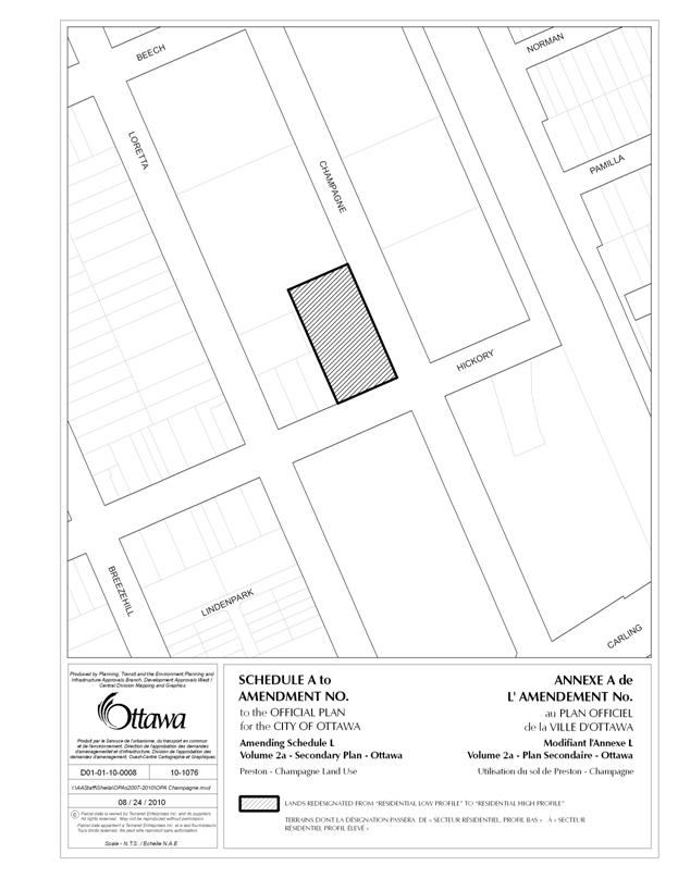
LOCATION MAP DOCUMENT
1
PROPOSED
OFFICIAL PLAN AMENDMENT DOCUMENT
2
Official Plan
Amendment Modification du Plan
directeur
To the Official Plan of the City of Ottawa
Land use
Utilisation du sol
THE STATEMENT OF COMPONENTS
PART A – THE PREAMBLE does not constitute part of the Amendment.
Purpose
Location
Basis
PART B – THE AMENDMENT consisting of the following
text constitutes Amendment. No. __ to the Official Plan of the City of Ottawa (2003).
Introduction
Details of the Amendment
Implementation and Interpretation
Schedule A of Amendment __ – Official Plan of the City of
Ottawa
PART
A – THE PREAMBLE
Purpose
The purpose of this Amendment is to
change the Land Use designation of the property from Residential Low Profile to
Residential High Profile. The Amendment
will facilitate the redevelopment of the property with a 12-storey apartment
building.
Location
The lands affected by this
Amendment are located on the north side of Hickory Street and west side of
Champagne Street. The lands are known
municipally as 100 Champagne Avenue South.
Basis
Background
The proposal consists
of a 12-storey high-rise apartment dwelling with 94 units fronting onto
Champagne Avenue South, and a three-storey multiple attached (townhouse)
dwelling with six units fronting directly onto Hickory Street. The purpose of the Official Plan Amendment is
to amend the Preston-Champagne Secondary Plan from Residential Low Profile to
Residential High Profile.
Context
Section 2
of the Planning Act outlines those land use matters that are of
provincial interest, to which all City planning decisions shall have
regard. The provincial interests that
apply to this site include the appropriate location of growth and development
and the promotion of development that is designed to be sustainable to support
public transit and to be oriented to pedestrians. In addition, the Planning Act
requires that all City planning decisions be consistent with the Provincial
Policy Statement (PPS), a document that provides further policies on matters of
provincial interest related to land use development. PPS policies indicate that
there should be an appropriate mix of uses to support strong, liveable,
and healthy communities.
The proposal
allows for development of a density that will efficiently use land and
contribute to a balanced community. The site is conveniently located
near transit (Carling O-train station), and nearby residential and commercial
areas to allow for access by pedestrians and transit. The site is located within one block of an
Arterial Road (Carling Avenue), which provides good access to the site
and is a focus for existing and future mixed-use development. Staff conclude that the proposal is consistent
with the matters of provincial interest as outlined in the Planning Act
and PPS.
Section 2.3.1 of the Official Plan sets
broad strategic directions to meet the challenge of managing growth, providing
infrastructure, maintaining environmental integrity and creating livable
communities within Ottawa. To meet these challenges, polices are set out to
pursue a mix of land uses and compact forms of development which in turn will
enable the City to support a high-quality transit system and make better use of
existing infrastructure and roads. The
proposed development will support this overall goal.
The site is designated as “Mixed
Use Centre” on Schedule B of the Official Plan.
The Mixed-Use Centre designation permits a broad variety of uses and
encourages transit-supportive land uses with the goal of creating complete
neighbourhoods. These areas are intended
to include a broad range of land uses, such as offices, retail, schools,
hotels, hospitals, large institutional buildings, recreation and entertainment
facilities, entertainment uses, services, high and medium-density residential
uses, and mixed-use development. The
Mixed-Use Centre designation identifies areas that are strategically located
with respect to the transportation system and are accessible by transit,
walking, cycling and automobile. They
are centered on rapid transit stations and contain one or more arterial roads
with all-day frequent transit service.
Mixed-use centres are one of the target areas identified for
intensification. The Bayview-Preston
Mixed Use Centre has a minimum target density at 2031 of 285 people and jobs
per net hectare.
The proposed development has a
density of 669 people and jobs per net hectare, and thus meets the minimum
target density. It is located within 600
metres of the Carling O-train station, near arterial roads, and multi-use
pathways, which facilitate travel by all modes and encourages transit use. The proposal redevelops an underutilized site
in an area that is characterized by several properties in transition from
industrial uses to more intense development.
The proposed high-density residential use is specifically permitted in
the Mixed Use Centre designation, and fulfils the housing objectives through the
inclusion of multiple types of housing.
In light of the above, the proposed development is consistent with the
direction of this land use designation.
The Preston-Champagne Secondary Plan in Volume
2 of the Official Plan seeks to reinforce the area as a diverse inner
city neighbourhood with a broad mix of uses.
It will allow major redevelopment that transitions to existing lower
profile residential areas. The southwest
quadrant, where the subject site is located, will incorporate new office and residential
development, which will transition down in height when moving away from Carling
Avenue. The plan also seeks to enhance
Preston Street as the main pedestrian-oriented shopping area and community
focus. The “Residential Low Profile”
designation, which applies to the subject site permits predominately
residential low profile uses to preserve its residential character.
At the time the Secondary Plan
was developed in the early 1990s, the use of the rail corridor for light rail
had not yet been contemplated, and thus proximity to rapid transit was not
considered as a factor in determining the land use designations in the
plan. The O-train station being less
than 600m from the site provides rationale for reconsidering the low-profile
residential designation in favour of a more intense form of development that
takes advantage of the proximity of rapid transit.
The site is flanked by an
existing 14-storey residential building to the north, existing high-rise office
buildings to the south, and lands approved for high-rise mixed-used development
to the east southeast. Council approved
an Official Plan Amendment and Zoning By-law amendment on the site directly to
the east for an 11-storey residential building in 2002, which contributes to
this evolving environment. The proposed
building height of 42 metres is in keeping with the established and unbuilt
context in the surrounding area. The
site represents the edge between an existing low-profile neighbourhood (heights
ranging from 11m to 18m) and an emerging high-profile neighbourhood. Additionally, the grade change from west to
east is approximately one storey, which contributes to reducing the impact of
height as perceived from the west.
The proposed amendment to
“Residential High Profile” will allow redevelopment in accordance with the
vision set forth in the Preston-Champagne Secondary Plan. This redevelopment, being located one block
from Carling Avenue in an area characterized by vacant or underutilized industrial
sites, enhances the urban streetscape and removes a non-conforming industrial
use. The proposed height is in line with
the surrounding context and design of the building creates an adequate
transition to low-profile residential.
Sections 2.5.1 and 4.11 of the
Official Plan outline the objectives and policies for compatible
development. Among the considerations
are: traffic, vehicular access, parking requirements, sunlight, amenity area,
built form, and relationship to supporting community services. The proposal was also reviewed in light of
the Urban Design Guidelines for High-rise Housing. The following is an analysis of the
applicable criteria, which demonstrates that the proposed development satisfies
the compatibility tests of the Official Plan in a way that does not result in
undue adverse impacts.
a) Traffic/transportation: A Community Transportation Study was
submitted in conjunction with the development applications. The study takes into consideration the three
proposed high-rise developments in the immediate area. The study finds that the proposed development
will generate a maximum peak hour traffic volume of 50 vehicles per hour, which
is less than 10% of the total peak hour traffic generated by the three
proposals combined. Other impacts on the
transportation network, such as road modifications, will be addressed through
the Site Plan Control process.
b) Sunlight: A Sun Shadow Study
was provided which shows the extent of shadows generated by the proposed
development. Shadows from the building
measured at the key times of the year primarily impact the surface parking lot
to the north and the lands adjacent to the O-train corridor that are expected
to redevelop in the future. The shadow
impacts of the proposed building on the existing low-profile residential
neighbourhood to the west are minimal compared with that already experienced as
a result of the adjacent 14-storey residential building.
c) Supporting neighbourhood
services: The inclusion of car-sharing
spaces within the building provides a neighbourhood service to the surrounding
community. The site is within one block
of a City Park, and is in close proximity to the Dow’s Lake greenspace, thus is
within close proximity to existing services.
d) Built form: The proposed development incorporates
low-rise ground-oriented townhouses along Hickory Street, which continues the
existing pattern of development present to the west. The treatment of the Champagne frontage
includes articulation of the lower portions of the building in order to
emphasize the pedestrian realm, create a more human-scale environment, and to
continue the established low-rise development pattern in the area. The proposed 12-storey building incorporates
an additional setback on the upper two storeys creating a distinct base,
middle, and top of the building, which creates interest and lessens the impact
of height. Building height is discussed
in more detail in the Secondary Plan section above.
Other design and compatibility
elements, such as noise, lighting, fencing, and microclimate (wind), will be
addressed through the concurrent Zoning By-law Amendment and Site Plan Control
process.
PART B – THE AMENDMENT
1.
Introduction
All
of this part of this document entitled Part B – The Amendment consisting of the
following text and the attached Schedule A constitutes Amendment No. __ to the
Official Plan of the City of Ottawa.
2.
Details of the Amendment
The
Preston Champagne Secondary Plan of the Official Plan Volume 2A of the City of
Ottawa is hereby amended as follows:
2.1.
Schedule L “Preston-Champagne Land Use” is amended to
include the following change as shown on Schedule A attached hereto:
i.
redesignate the lands known municipally as 100
Champagne Avenue South from Residential
Low Profile to Residential High
Profile;
ii.
add Residential
High Profile to the land use categories
2.2.
Section 6.2 “Vision” is amended by adding the following
provisions immediately following the last sentence of the text entitled “Southwest Quadrant”:
“High
profile residential development is permitted on the north west intersection of
Hickory Street and Champagne Avenue.”
2.3.
Section 6.4 “Policies” is amended by adding a new subsection
6.4 (f) and re-numbering the existing subsections (f) to (aa) inclusive, as
follows:
“Residential High Profile f) City
Council shall permit high profile residential uses within this area. Limited commercial uses are permitted on
Champagne, but the predominant use shall be residential. Low and medium profile residential uses are
also permitted.”
3.
Implementation and Interpretation
Implementation
and Interpretation of this Amendment shall be made having regard to applicable
policies set out in Volume I – Primary Plan of the City of Ottawa Official
Plan.
SCHEDULE A
DETAILS OF RECOMMENDED ZONING
DOCUMENT 3
Proposed
Changes to the Comprehensive Zoning By-law
1.
The Zoning Map of City of Ottawa Zoning By-law
2008-250 is amended by changing the zoning of the lands known municipally as 100 Champagne Avenue South from R4M
(Residential Fourth Density Subzone M) to R5P Sxxx (Residential Fifth Density
Subzone P, Schedule xxx);
2.
Add to Part 17 the schedule as shown in Document
4 as Schedule xxx.
SCHEDULE xxx DOCUMENT
4
PROPOSED SITE PLAN DOCUMENT
5
CONSULTATION DETAILS DOCUMENT
6
NOTIFICATION
AND CONSULTATION PROCESS
Notification
and public consultation was undertaken in accordance with the Public
Notification and Public Consultation Policy approved by City Council for
Official Plan and Zoning By-law amendments.
There were seven comments received from the public on this proposal.
SUMMARY OF PUBLIC INPUT
Comment: Parking
The proposal for 109 parking
spaces for 100 dwelling units does not fit with the City’s plan to encourage a
pattern and density of development that supports transit, cycling and walking
as viable alternatives to the automobile.
The City should restrict the number of parking spots to support its
strategic direction. Another comment
indicated that six visitor spaces for 100 units is not adequate.
Response:
Except for the reduction in
visitor parking, the parking proposed for the development falls within the
minimum and maximum parking requirements expressed in the Zoning By-law for this
type of use when within 600m of a rapid transit station. The justification for the reduction in
visitor parking is described in the Discussion section above.
Comment: Transportation
Area local and collector streets
cannot handle the traffic proposed by this and the surrounding development
proposals. The cumulative impacts of
development in the adjoining properties will add two thousand cars, and this
needs to be considered. The City should
consider ways of ensuring that Hickory, Sherwood and other residential roads in
the area do not effectively become collector roads for people trying to get to
the Queensway and Preston. It is suggested
that “no entry during peak hours” signs be installed at Hickory/Champagne,
Champagne/Beech, and Hickory/Loretta to divert traffic to Carling. It may be necessary to block the road, or
convert to one-way traffic local streets, such as Beech, Hickory, Bayswater and
Loretta. It is also suggested that the signal timing at Carling/Champagne be
adjusted to encourage drivers to use Carling.
Response:
The
Community Transportation Study takes into consideration all three new
development proposals in the area, and indicates that the impact on local and
collector streets in the area is relatively minor. Suggestions for specific road modifications
and transportation improvements will be addressed through the Site Plan Control
process.
Comment:
Servicing
It is
publicly known but not well understood that the City lacks servicing capacity,
particularly sewer capacity to serve the development proposals coming forward
from this and neighbouring properties. It
doesn’t look like this study considers the cumulative effect of 100 Champagne,
855 Carling and 125 Hickory. The
engineering consultants make the following observation and then conclude that
Hickory Street sanitary and storm sewers “have sufficient available capacity to
allow the connection of increased sanitary and storm sewers flows from the
proposed use of this site compared to the previous use which discharged
directly to Champagne Street sanitary and storm collectors.”
Response:
The servicing study did consider
all three current development proposals.
This area was formerly a combined sewer area (storm and sanitary sewer
in one pipe) and has been separated in the last few years, meaning that storm
drainage from this area has now been removed from the Cave Creek sanitary
collector sewer. The sanitary flows that
are being added due to the development of all three proposals are small
compared to the storm drainage that used to be directed to the sanitary system
prior to separation. Stormwater
management controls are being imposed on all new developments to ensure that
future peak flows from the respective sites are actually less than existing
peak flows. Also, this being a partially
separated area, foundation drains are not connected to homes meaning that
surcharging of the storm system will not lead to basement flooding.
Comment:
Height
There are several comments with
varying recommendations on height: same height as single-detached homes, no
higher than six storeys, and no higher than eight storeys. The extra height impacts immediately the
sunlight to surrounding homes. Infill should
be done on a reasonable scale. Development
of the lands in question must adhere to the "Low Profile Residential"
designation as provided in the Preston-Champagne Secondary Plan. The transition
from single family dwellings along
Beech, Hickory and the surrounding streets should respect the compatibility
factor advocated in the Official Plan
and all other planning guidelines. A
clear boundary should be created between the “established neighbourhood” and
the “development area”, including a transitional zone located within the “
developmental area”. The "Emerald
Towers" is an anomaly in the area, and
should not be used as a precedent.
Response:
Height, sunlight, transition and
context are all addressed in the Discussion section above.
Comment: Greenspace
There should be more green space
incorporated into the development, including trees, landscaping, gardens. Large trees provide shade and act as filters
for the pollution generated from cars, etc.
Response:
New street trees are proposed
along both Hickory Street and Champagne Avenue, in addition to landscaping
being provided adjacent to the street on private land, as well as part of the
amenity area above the one-storey podium.
The site is within one block of a City park.
Comment: Community development
The community needs commercial
development, services, and a grocery store within walking distance. The community should be designed
comprehensively, thus the Bayview-Carling Community Design Plan (CDP) go ahead
first before this is considered.
Response:
The need for locally-oriented
services is understood, and services of this kind are proposed in an adjacent
development proposal. The
Bayview-Carling CDP is underway, however, there is no legal mechanism currently
in place to restrict development applications from being considered in the
interim.
Comment: Privacy
There is no privacy between the
new units in the high-rise and the townhouse units.
Response:
The high-rise dwelling and
townhouses share the same amenity space on the roof of the one-storey podium,
and the development is conceived as one entity.
Homebuyers will be well aware of the arrangement present in this
development upon making their purchase and will make decisions according to
their preferred lifestyle.
COMMUNITY ORGANIZATION COMMENTS
Civic Hospital Neighbourhood
Association
I am writing on behalf of the
Civic Hospital Neighbourhood Association (CHNA) to comment on the proposed
development at 100 Champagne Avenue South.
To begin, I would like to state that CHNA understands that the City of
Ottawa’s Official plan (Official Plan Amendment 76) promotes intensification as
a strategy to manage growth in a sustainable way and that it has targeted areas
near rapid transit for intensification, including the area near 100 Champagne
which is located next to the Carling O-Train stop. The CHNA also understands that the primary
goal of the City’s Official plan is sustainability, “where sustainable development
is defined as ‘development that meets the needs of the present generation
without compromising the ability of future generations to meet their own
needs.” We fully support this goal and
hope to work with the City to manage growth in a way that meets the needs of
our community, both now and in the future.
With this in mind, we would like to raise a number of concerns in
connection with 100 Champagne.
Transportation study conclusions:
The 100 Champagne Avenue: Residential Complex – Community Transportation Study
concludes with the following comments:
“The principal impact of the
currently underway and proposed developments (Domicile, Arnon and Mastercraft
Starwood) on local streets is anticipated to occur on Sherwood Drive at Carling
Avenue, based on the assumption that the additional traffic to/from Carling
Avenue west of Champagne Avenue will likely get redistributed to/from Sherwood
Drive at the Carling/Sherwood signalized intersection in the same proportions
as currently prevail at that intersection.
Consequently, the two-way peak traffic volumes on Sherwood Drive between
Carling Avenue and Breezehill Avenue are projected to increase by approximately
70 vph by 2016. With less than 500 vph two-way total at this location during
peaks, the projected volumes are still considered to be reasonable for a
collector road. It is noteworthy that the two-way peak hour volumes on Sherwood
Drive at Parkdale Avenue are approximately 50% of the two-way volumes at
Carling Avenue. Since an average of 85% of the traffic on Carling Avenue east
of Sherwood Drive originates from/is destined for Carling Avenue, west of
Sherwood Drive, the resultant 15% of the projected increased traffic volumes
resulting from the proposed Domicile, Mastercraft Starwood and Arnon
developments is considered to be a relatively minor increase in Sherwood Avenue
traffic volumes, as it applies principally to the section of Sherwood Drive
between Carling Avenue and Breezehill Drive. The existing traffic volumes on
the local road network, Hickory, Breezehill, Beech, Loretta, etc., are relatively
minor and are expected to increase by less than 40 vehicles per hour, as a
result of all the proposed developments in the area, including Domicile, Arnon
and Mastercraft Starwood. As the overall
traffic impact of the proposed Domicile residential development at 100
Champagne Avenue represents a net increase of 5% to 7% in additional peak hour
traffic volumes likely to be generated by all the known development proposals
in the area at this time, and as the additional traffic impact on adjacent arterial
and collector streets is judged to be quite minor, not resulting in the need
for improvements of any significance, the proposed rezoning and OPA are judged
to be appropriate in this case.”
The CHNA does not agree with this
conclusion. Much of the information collected on traffic counts was collected
during the dead of summer and a period of major construction on Preston Street.
We think it safe to assume that these factors affected both the volume of
traffic and the way people use our roads.
We would like to point out that a consulting firm called Delcan
collected information for the Carling and Sherwood intersection (the
intersection identified as having “the principal impact” ) on August 19, 2009.
Traffic counts for Carling and Champagne were collected on August 17, 2009.
Counts for Beech and Preston were collected on July 18, 2006. Counts for
Parkdale and Sherwood were collected on June 30, 2009. Also, there does not
appear to be traffic counts for some of the intersections that are likely to be
most affected: Champagne and Beech; Hickory and Loretta; Hickory and
Breezehill; Hickory and Bayswater.
The proposed development at 100
Champagne and other proposed developments in the area would add more than 1240
vehicles to our streets. Most of these vehicles are likely to arrive and leave
during peak traffic hours. This increase in traffic would undoubtedly and
negatively impact the livability of our streets. We wholeheartedly agree with
the late Donald Appleyard. Appleyard,
who was a professor of urban design,
believed that social street activities are greatly reduced and feelings
of well being in neighbourhoods are threatened when traffic volumes increase
beyond what is considered normal by local residents (Source: Donald Appleyard,
Livable Streets. Berkeley, CA.: University of California , 1981).
The CHNA would like to work with
the City of Ottawa to preserve the livability of our streets by maintaining
current traffic patterns to the extent possible. One of the best ways to do
this would be to ensure that traffic emanating from developments such as 100
Champagne is diverted to Carling.
The City could also reduce the
number of vehicles that proposed developments such as 100 Champagne are
scheduled to add to our streets by reducing the number of vehicle parking
spaces. In theory, this measure would also strengthen the link between
development and public transit. At the moment, the proposal for 100 Champagne
would add a parking spot/vehicle per apartment or townhouse, as would the
proposed development at 125 Hickory.
Reliability of information: The
CHNA also has concerns about the reliability of the information provided by
Delcan’s transportation study. Delcan’s study was prepared for the developer
(Domicile). We have a very hard time believing that this document is impartial
and suspect that Delcan may be providing information in a selective
manner. For example, Delcan provides
collision data for study area roads between 2005 to 2008 and concludes
“Analysis indicated no particular trends in collisions along the subject
section of Carling Avenue. Most of the collisions (76%) involved only property
damage, indicating low impact speeds, while the rest were non-fatal.” One might
assume, based on this information, that there were no fatal traffic accidents
between 2005 and 2008 but this would be incorrect. Collision data only provides
information about vehicles hitting vehicles. It does not include information
about vehicles hitting people. We know of at least one fatal accident that
occurred in March of 2005. A man and his dog were tragically killed by a car at
Carling and Sherwood.
(Source:http://members.shaw.ca/leatherlion/benkozak/index.htm).
No Community Development Plan:
The Carling Bayview Light Rail Transit Corridor Community Design Plan is not
yet completed. Development is usurping planning at this point. We think the
City needs to work with the CHNA to address problems that are created by this
fact.
In short, the CHNA believes that
the City needs to do more to ensure that development is sustainable for both
current and future residents, as mandated in the Official Plan, and that it
incorporates the seven guiding principles of Ottawa’s 20/20 initiative into its
plan by working towards stated objectives such as the following:
•The link between development and
public transit is strengthened.
• Focusing on alternative modes
of transport and reducing the reliance on the automobile for improved air
quality.
• A better-balanced
transportation system, which puts more emphasis on transit, cycling and pedestrian
facilities, and improves mobility and access for all citizens, including those
who do not own a car.
•A full range of commercial goods
and services for residents is available at appropriate locations throughout the
city.
Recommendations for 100 Champagne
Proposal
The CHNA would like to make the
following recommendations with a view to addressing some of the above concerns
and helping the City take measured steps to implement the Official Plan and
20/20 objectives:
1) Reduce the number of vehicle
parking spaces and add bicycle and additional Vrtucar parking spaces.
2) In order to divert traffic to
the Carling arterial, we recommend the following:
a) ‘No entry from 6:00 a.m. to 9:00 a.m. and from 3:00 p.m to
6:00 p.m’ signs at Hickory and Champagne (going North and West) to divert
traffic to Carling during rush hours.
b) A‘No entry from 3:00 p.m to 6:00 p.m’ sign at Champagne and
Beech to encourage traffic to enter from Carling at the end of the day.
c) A ‘No entry from 3:00 p.m to
6:00 p.m’ sign at Hickory and Loretta to encourage traffic to enter from
Carling at the end of the day.
This proposal should encourage
the proper use of the Carling arterial if people are respectful of the signs.
If they are not, it may be necessary to block the road at Champagne and Beech
as well as Hickory and Loretta.
3) Ensure that City of Ottawa
staff make it a priority to find solutions to other traffic and parking issues
in the CHNA catchment area, especially in light of the fact that developments
such as 100 Champagne are proceeding prior to the completion of the Carling
Bayview Light Rail Transit Corridor Community Design Plan.
4) Do not consider any new
developments or zoning by-law amendments in the area until the Carling Bayview
Light Rail Transit Corridor Community Design Plan (CDP) is completed. Ensure
that the CDP gives priority to adding services and infrastructure in the area
so that residents can walk or bike rather than drive.
Thank you for considering our
views. If you have any questions or concerns, please do not hesitate to contact
either myself (Katherine Steinhoff) or CHNA President Amanda Farris.
Response:
Most of these comments have been
addressed in the Discussion section or in the responses to public comments
above. Experience has shown that summer
traffic volumes do not differ significantly from the rest of the year. Transportation studies that are provided for
development applications are prepared by professional consultants, and are
reviewed by City staff to ensure they are satisfactory.
ACS2010-ICS-PGM-0162 KITCHISSIPPI
(15)
(This matter is
Subject to Bill 51)
The following written submissions
were received with respect to this item, which were circulated and are held on
file with the City Clerk:
·
E-mail received 13
September 2010 from Katherine Steinhoff, Civic Hospital Neighbourhood
Association
·
Comments received 13
September 2010 from Mary Girard
Kalle Hakala provided an overview
of the application and staff’s rationale for recommending approval. He did so by means of a PowerPoint
presentation, a copy of which is held on file with the City Clerk.
In response to questions from
Councillor Leadman with respect to what had been done to address the
community’s concerns, Mr. Hakala confirmed that staff were in discussion with
the applicant regarding transportation improvements to the area as part of the
Site Plan process. With respect to the
design of the building, he noted that the lower portions of the building were
moved closer to the street, to give more of a human scale and match the
existing character of the area. He
further noted that other things were done before submission of the application,
including the inclusion of multiple attached units along Hickory Street to
match the character of the area. Also,
more definition was given to the upper portion of the building to reduce the
impact of the height.
Councillor Leadman noted that 52
requests for changes were submitted to the applicant. Mr. Hakala expressed his understanding that
the applicant had provided a response to each, and noted staff felt the
responses were adequate to proceed with the Zoning By-law amendment and
Official Plan (OP) Amendment. Although
there are some other minor issues that remain, they will be addressed through
the site plan process. Mr. Hakala also
confirmed that there would be two Vrtucar car sharing spaces and bicycle
parking in accordance with the Zoning By-law.
In response to questions from Councillor
Leadman with respect to the consideration given to the Secondary Plan, Mr.
Hakala explained that staff follows the Secondary Plan when it in force;
however, they can always re-evaluate it based on new information in considering
a specific development proposal. In this
case, the Secondary Plan was approved prior to the O-train and the designation
of the corridor as a rapid transit route for future expansion. He also noted
that the area was undergoing a Community Design Plan (CDP) process.
Councillor Leadman expressed the
community’s desire to have no further development approved in the area before
the Carling-Bayview CDP was complete.
She expressed concern that the area was facing so many re-zoning
applications without an overall model in place for what the area can support. She wondered what steps could be taken with
future applications to address overall issues such as traffic and
infrastructure.
Mr. Hakala explained that staff
must adhere to the mandatory timelines set out in the Planning Act for processing OP and Zoning By-law amendments, or
face appeal to the Ontario Municipal Board (OMB) for lack of decision. He further noted that, through the OP and
Zoning By-law amendment process, staff considered the broader implications of
the development on such things as servicing and transportation. He further confirmed that this effort would
continue for future developments in terms of traffic that is generated in the
area.
In response to further questions
from Councillor Leadman, John Moser, General Manager of Planning and Growth
Management confirmed that staff adheres to the Secondary Plan; however, there
are mechanisms and circumstances where staff look at proposing changes to them.
Committee then heard from the
following public delegations:
Shirley Reyes, Civic Hospital
Neighbourhood Association (CHNA) spoke in opposition to the proposed amendment. She raised the following points:
With respect to the environmental
impact, she expressed the importance of having a clean environment and the
benefits of having trees surrounding the dwellings in a community to provide
shade and other benefits. She conveyed her
concern that this development was denying the setback that would enable this to
happen, suggesting the tree cover was inadequate
With respect to height, she
argued that the height of the proposed building was excessive, and there was
inadequate transitioning between high-profile development near Carling Avenue
and the existing low-profile residential development. She noted that the development amounted to a
tripling of the permitted height in the Secondary Plan, suggesting this was an
unacceptable increase incompatible with the neighbourhood comprised of single
family dwellings. She expressed the Neighbourhood
Association’s position that the permitted height should not exceed six metres.
On the issue of traffic impacts,
she noted that the OP states there should not be adverse impact on a viable
community, and maintained that this was a viable community and would be
adversely impacted by the traffic from this and other proposed developments in
the area. She noted the neighbourhood
was already heavily impacted by traffic, suggesting the Parkdale Avenue
Queensway interchange was already overused and failing. She also suggested Parkdale Avenue carries
more cars in one hour in one lane than Carling Avenue does in three lanes; as a
result, traffic from new developments would need to be funnelled to Carling
Avenue, which would ultimately become congested as well. She further noted that all the roads in the
area were two lane residential streets, regardless of their official designation,
and could not accommodate the existing traffic much less additional pressure
from the new development in the area. She pointed out that the rapid transit
expansion would not happen for another ten years.
Ms. Reyes also asserted that the
traffic study prepared by Delcan was flawed and biased, given that it was
commissioned by the developer, and did not take into consideration the concerns
of the community. She argued that there
was a need for an independent traffic impact study, which should not be done by
the current consultant.
With regards to consultation, Ms.
Reyes argued that it was insufficient.
She noted that she had only ever heard one presentation in August 2009,
and suggested the community was never engaged in meaningful discussions on this
site as there was only one presentation in August 2009. She suggested the developers never engaged
the community in a dialogue about this development. She expressed frustration with the appearance
that the community was not being listened too, and that Committee would “rubber
stamp” developments. Ms. Reyes also
referenced another development by the applicants, near Loretta Avenue and
Breezehill Avenue, which she suggested was a mistake. She urged Committee not to repeat that
mistake, and not to allow the development to proceed as proposed.
Miguel Tremblay, FoTenn Consultants was present on behalf of the applicant, Domicile
Developments, in support of the application.
He was accompanied by Ron Jack of Delcan, who spoke to
transportation issues and the traffic study. He began by noting that the area
had been identified as a growth area, with several landowners expanding in the
quadrant and a transit station planned.
He suggested there were clear opportunities for intensification to
accommodate some of the City’s vision for growth in the area.
With respect to comments made with respect to
sustainability, Mr. Tremblay proposed that there was a reasonable amount of
parking on the site, and the intent was to meet the requirements of the By-law
and not burden the adjacent community with on-street parking, without providing
excessive parking. He also suggested the
project made a meaningful attempt to provide a green edge and noted there would
be street trees and a rooftop patio. He
acknowledged that some of the setbacks were smaller in order to meet the City’s
urban design objectives.
To the issue of building height and transitioning,
Mr. Tremblay highlighted the transitioning provided by the planned townhomes on
Hickory Street, which he suggested were in keeping with the fabric of the
neighbourhood and a nod to the Secondary Plan. He noted the proposal also responded to the
greater building heights that are expected in the areas surrounding the transit
station on the east side of Champagne Avenue, some of which are approved by
Committee. He felt that development,
plus the existing 14-storey building, provided a meaningful degree of
transition, and that the OP objectives had been addressed.
Mr. Jack then spoke to the transportation issues and
Delcan’s approach in undertaking the traffic study. He began by highlighting the close proximity
of the site to the existing O-Train corridor and planned rapid transit
expansion. He noted the City would be
investing heavily in rapid transit, and the purpose of creating density around
transit stations was to allow people to live where they are not dependant on
cars. He suggested that allowing this
quadrant to develop density of office and residential was a responsible
transportation solution.
Mr. Jack noted that his firm had done the traffic
impact studies for several proposals in the area. He suggested this allowed them to build one
upon the other and provide staff with the benefit of the overall traffic
picture for the area. He noted that,
having done a Parkdale Area transportation study, they were aware of the area’s
transportation issues and the traffic volumes on area streets. He noted that Sherwood Drive was not a local
street, but rather a collector street.
He also stated that Carling Avenue carries 25-20 per cent more traffic
than Parkdale Avenue.
With respect to this development, Mr. Jack indicated
that it would generate less than one new vehicle per minute to surrounding
roads at peak hours. He further noted
that, due to the multiple routes available to access the building, any one
street or intersection would be minimally impacted and not every car would
access the Parkdale Avenue Queensway interchange.
In response to questions from the Chair, Mr. Tremblay
confirmed that the City provides guidelines for the traffic impact studies. At the outset, there is a pre-consultation
with City staff to determine the issues and the work is then scoped to those
issues, and staff reviews it throughout the process.
In response to questions from Councillor Leadman,
Mr. Tremblay explained that for mixed-use centres there are targets for jobs
and new residents. He noted that the
staff report speaks to a target density in this district of 285 people and jobs
per net hectare, and proposed that the development fit within this requirement. He further noted that mixed-use areas are
clustered in proximity to transit and arterial roadways, and are intended to be
in areas that are already characterized by high-rise buildings.
Councillor Leadman noted that when speaking of
transitioning Mr. Tremblay had referenced another property that had not yet
received approval, and suggested this was inappropriate, and argued that
development should not move forward.
In response to questions from Councillor Leadman with regards to the
modal split used for the traffic study, Mr. Jack explained that the split was
approximately 30 to 40 per cent for walk, bike and transit, with the residual
being automobile. While he did not
believe any of the studies for the area had assumed a 52 per cent modal split,
he suggested perhaps some the broader projections for the area for the OP
horizon were aiming for that split. Mr.
Jack further explained that in undertaking a traffic study they look at the
proximity of the site to transit and employment opportunities and make an
educated assumption on what is an appropriate modal split. He noted that they tried to be transparent
and fair in those assumptions in order not to under-estimate the traffic
impacts for the community.
In response to questions from Councillor Leadman about the designation of
Sherwood Drive as a collector road, Mr. Jack explained that the designation of
a street had less to do with the uses along it than with its connectivity and
function. Although it has residential
uses along it, Sherwood Drive is designated as a collector road because it is a
through street whose function is collecting traffic from local streets and
distributing it to arterial roads. He
noted that as part of the previous transportation study traffic calming
measures were recommended to make the road safer for pedestrians and cyclists,
and measures were put in at Parkdale Avenue to eliminate some of the cross
traffic to Holland Avenue. He suggested
those measures had be put in to address City and community concerns with
respect to safety and traffic flow.
Councillor Leadman suggested that the level of intensification in the
area would generate much more traffic.
She noted that traffic studies for individual developments never
indicated there would be a problem, yet traffic was becoming a major problem
for the community overall. On the issue
of modal split she suggested that, although the aim was to move people to other
forms of transportation, the reality was that in this particular corridor there
were no amenities to walk or cycle to, leaving residents reliant on their
vehicles. She acknowledged the efforts
of the developer to address some community concerns, but emphasized that the
impact on Sherwood Drive.
Councillor Doucet inquired if Mr. Jack, in his extensive experience doing
traffic studies, had ever come forward to Committee and Council to say a
development was too large. Mr. Jack
estimated that he had completed between 500 and 1000 traffic studies. He confirmed that many developments have
transportation and site operation problems at the beginning of the process;
however, those issues rarely make it to Committee and Council because the
transportation consultants’ job is to work with the applicant and fix those
problems before it reaches that stage.
He noted that all developments have a traffic impact, and emphasized his
job was to quantify that impact in a transparent and believable way, advise
whether there would be capacity problems, and what modifications would be
required to address those.
Councillor Doucet noted that he frequently heard from communities that
developments were too big. He noted that
people buy their homes with an understanding of what would be permitted by the
zoning, and that they wished the City would respect the zoning that is in
place. He could not recall any traffic
planner in a public forum who would support what the community wanted. On the issue of this development, he
maintained that it was too big and should be limited to six stories.
Having concluded all public delegations, the Chair turned the
recommendations over to Committee for discussion and debate.
Councillor Leadman expressed the concerns of her community with respect
to intensification and how it is applied.
She suggested the City needed to start treating communities in a broader
context, interpreting what is meant by intensification, transitioning, traffic
impacts or infill and identifying what was appropriate. Specifically, she
recommended that more caution needed to be taken with target areas such as this
one. She noted that there was a CDP underway for this area whose purpose was to
look at intensification along the corridor, and expressed the community’s
frustration with applications coming forward in the absence of a broader policy
and guidelines for the area. She noted
that residents base their decisions about where to live on the Zoning and
Secondary Plans in place, and suggested the need for some stability so that
people can have some trust in what would be coming forward for their community.
Councillor Doucet expressed his frustration with development that did not
respect the Zoning in place. He referenced
a project by the same developer in his own ward, noting that although it
represented significant intensification it was not opposed by the community
because it respected the existing Zoning and the quality of life of the
existing neighbourhood. In contrast, he
suggested this development in this area was an “asphalt nightmare” with no
trees and no parking. He questioned why,
although the area is supposed to be transit-friendly, a development had been
approved nearby with 800 parking spaces.
He suggested this represented the kind of intensification that was
profitable for the developer, but was not rendering the City more sustainable
or profitable. He suggested that, as
stewards for the City, Council should be respecting its own laws and thinking
about how to create environments that are not asphalt jungles, but rather
human-friendly environments.
Councillor Bellemare expressed his support for the proposal. He noted there were buildings to the north
and south of the site similar in size to that which was proposed. In addition, he noted the site’s proximity to
the O-Train. He suggested the
development represented exactly the type of intensification the City needed to
embrace. Considering the high quality of
the proposal, he recommended Committee approve the staff recommendations.
Committee then voted on and approved the report recommendations, as
presented:
That the Planning and Environment Committee
recommend that Council:
1.
Approve
and adopt an amendment to the Official Plan Volume 2A: Secondary Plans for the
Preston-Champagne Secondary Plan to re-designate 100 Champagne Avenue South
from “Residential Low Profile” to “Residential High Profile”, as detailed in
Document 2; and
2.
Approve an amendment to Zoning By-law 2008-250 to change the
zoning of 100 Champagne Avenue South from R4M (Residential Fourth Density
Subzone M) to R5P Sxxx (Residential Fifth Density Subzone P, Schedule
xxx) zone as detailed in Document 3, and shown
in Document 4.
CARRIED
