|
|
COMMITTEE RECOMMENDATION, as Amended
That Council approve an amendment to Zoning By-law 2008-250 to change the zoning of part of 340 McLeod Street from TM H(19.0) (Traditional Mainstreet, Height 19.0 metres) to TM [xxxx] Sxxx (Traditional Mainstreet, Exception xxxx, Schedule xxx), as detailed in Document 2, and shown in revised Document 3.
RECOMMANDATION DU COMITÉ, telle que modifiée
Que le Conseil approuve une modification au Règlement de zonage 2008-250 afin de changer la désignation de zonage d’une partie du 340, rue McLeod de TM H(19.0) (Zone de rue principale traditionnelle assortie d’une hauteur de 19.0 mètres) à TM [xxxx] Sxxx (Zone de rue principale traditionnelle, exception xxxx, annexe xxx), comme il est expliqué en détail dans le Document 2 et indiqué dans le Document 3 revisé.
Documentation
1. Deputy City Manager's report Infrastructure Services and Community Sustainability dated 23 September 2010 (ACS2010-ICS-PGM-0173).
2. Extract of draft minutes dated 4 October 2010.
Report to/Rapport au :
Planning and Environment Committee
Comité de l'urbanisme et de l'environnement
and Council / et au Conseil
24 September 2010 / le 24 septembre 2010
Submitted by/Soumis par : Nancy Schepers, Deputy City Manager/Directrice municipale adjointe, Infrastructure Services and Community Sustainability/Services d’infrastructure et Viabilité des collectivités
Contact Person/Personne-ressource : Richard Kilstrom, Acting Manager/Gestionnaire intérimaire, Development Review-Urban Services, Inner Core/Examen des projets d'aménagement-Services urbains, Unité du Centre intérieur
Planning and Growth Management/Urbanisme et Gestion de la croissance
(613) 580-2424, 22379 Richard.Kilstrom@ottawa.ca
|
SUBJECT: |
ZONING - Part of 340 McLeod Street (FILE NO. D02-02-10-0030) |
|
|
|
|
OBJET : |
REPORT RECOMMENDATIONS
That the Planning and Environment Committee recommend Council approve an amendment to Zoning By-law 2008-250 to change the zoning of part of 340 McLeod Street from TM H(19.0) (Traditional Mainstreet, Height 19.0 metres) to TM [xxxx] Sxxx (Traditional Mainstreet, Exception xxxx, Schedule xxx), as detailed in Document 2, and shown in Document 3.
RECOMMANDATIONS DU RAPPORT
Que le Comité de recommande au Conseil d’approuver une modification au Règlement de zonage 2008-250 afin de changer la désignation de zonage d’une partie du 340, rue McLeod de TM H(19.0) (Zone de rue principale traditionnelle assortie d’une hauteur de 19.0 mètres) à TM [xxxx] Sxxx (Zone de rue principale traditionnelle, exception xxxx, annexe xxx), comme il est expliqué en détail dans le Document 2 et indiqué dans le Document 3.
BACKGROUND
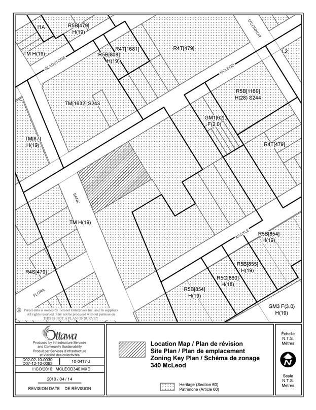
The site is located at 340 McLeod Street in Ward 14 (Somerset), on the southeast corner of Bank Street and McLeod Street. The 0.45-hectare site currently contains a four-storey office building and a surface commercial parking lot. The site is surrounded by a mid-rise residential building under construction to the north, an office building to the east, a four-storey residential building to the south, and two-storey commercial buildings to the southwest and west.
Proposal
The proposed development is located on a 0.2 hectare portion of the site closest to Bank Street, on what is now a surface parking lot. The proposal is for a nine-storey mixed-use building with 682 square metres of retail at-grade along Bank Street and 141 residential dwelling units, including three ground-oriented units along McLeod Street. There are two levels of underground parking with a total of 91 parking spaces, 78 of which are allocated to residential uses, and the remaining 13 for visitor parking. The proposal includes 72 bicycle parking spaces. A portion of the building is proposed to overhang above the first and second storeys such that there is a 0.0‑metre setback at the corner of Bank and McLeod Streets. Generally, the upper two storeys of the nine-storey building are proposed to be setback an additional 2.0 metres from the front and corner side lot lines. Amenity space will be provided through a combination of private balconies and common amenity space both within and outside the building, including an accessible green roof above the second storey at the rear of the building.
Existing Zoning
The site is zoned TM H(19) (Traditional Mainstreet – Height 19.0 metres) and is subject a Heritage Overlay. The site is within the Centretown Heritage Conservation District as designated under Part V of the Ontario Heritage Act.
Purpose of Application
The proposed development does not conform to the existing zoning on the property with respect to height, setbacks on upper storeys, parking, and permitted uses on the ground floor, therefore a Zoning By-law Amendment is required.
Proposed Zoning
The proposed zoning will make the following changes to the TM zone on this site:
· Increase building height from 19 metres (six storeys) to 28.7 metres (nine storeys)
· Reduce minimum front and corner side yards to 0.0 metres (seventh storey and below) for portions of the building at the corner of Bank Street and McLeod Street.
· Reduce retail and visitor parking ratios;
· To permit residential uses on ground level within six metres of the front wall along McLeod Street.
Companion Applications
A Site Plan Control application and an Application for New Construction in a Heritage Conservation District are being processed concurrently.
DISCUSSION
Planning Act and Provincial Policy Statement
Section 2 of the Planning Act outlines those land use matters that are of provincial interest, to which all City planning decisions shall have regard. The provincial interests that apply to this site include the appropriate location of growth and development and the promotion of development that is designed to be sustainable to support public transit and to be oriented to pedestrians. In addition, the Planning Act requires that all City planning decisions be consistent with the Provincial Policy Statement (PPS), a document that provides further policies on matters of provincial interest related to land use development. PPS policies indicate that there should be an appropriate mix of uses and range of housing types and densities which efficiently use land, resources, infrastructure and public service facilities, and support the use of alternative transportation modes and public transit.
The proposed zoning allows for a mix of residential and commercial uses, which will efficiently use land and contribute to a balanced community. The site is located on an arterial road and transit priority corridor (Bank Street), which provides excellent access to the site and is a focus for mixed-use development. The site is conveniently located near to residential and commercial areas to allow for access by pedestrians. The density of the proposal makes good use of existing urban lands, services, and infrastructure. Staff conclude that the proposal is consistent with the matters of provincial interest as outlined in the Planning Act and PPS.
Official Plan
Strategic Directions
Section 2 of the Official Plan sets broad strategic directions to meet the challenge of managing growth, providing infrastructure, maintaining environmental integrity and creating liveable communities within Ottawa. To meet these challenges, polices are set out to pursue a mix of land uses, housing types and compact forms of development which in turn will enable the City to support a high-quality transit system and make better use of existing infrastructure and roads. The proposed development provides a mix of uses and housing types at densities that will support this overall goal.
Land Use Designation
The site is designated as “Traditional Mainstreet” on Schedule B of the Official Plan. Traditional Mainstreets exhibit compact urban character with a pedestrian-oriented pattern of development and mix of uses that provide for access by a variety of transportation modes. Mainstreets are intended to function as mixed-use corridors in order to sustain the surrounding community and the transit system, and to provide a focus for the community. They are intended to establish a strong street edge with buildings that are human-scaled. This designation recognizes the importance of the site to achieving a positive pedestrian environment, and as a location for additional density. The plan supports building heights up to six storeys on Traditional Mainstreets. Greater building heights may be considered in accordance with the Compatibility and Design policies in the Official Plan; discussion of building height will be included under the Compatibility and Design subheading below.
The proposed development represents intensification of the site and has a density of 1235 people and jobs per net hectare. Although Traditional Mainstreets have no specific density targets expressed in the Official Plan, they are one of the target areas in the city where intensification is to be directed, and as such, a proposal such as this one satisfies the intent of the Official Plan policies for intensification and demonstrates that density can be achieved through a mid-rise, pedestrian-friendly built form. The proposed development achieves a more intense, yet human-scaled built form with a mix of uses in this part of Centretown and will contribute to supporting the public transit system and community services, and therefore is in conformity with the Traditional Mainstreet policies.
Centretown Secondary Plan
The Centertown Secondary Plan in Volume 2 of the Official Plan intends to conserve and enhance the residential character of Centertown as a downtown community with several identifiable neighborhoods focused around defined commercial corridors and public open spaces. The land use schedule defines land use designations reflective of the desired use and built form patterns. These designations are intended to serve as a framework within which the objectives and policy directions are to be achieved. In addition to the specific land use designations, the plan also includes site development, commercial, heritage, and transportation policies which apply to this proposal.
The site is designated as “Residential Office” on Schedule H of the Centretown Secondary Plan. This designation permits a wide range of retail, commercial, office, residential, and public uses. Although no specific building heights are specified in the designation, the Zoning By-law currently limits the building height to six storeys. The proposal includes both residential and retail uses, which satisfies the intent of the Residential Office designation. The increase in building height will be discussed under the Compatibility and Design subheading below.
New development in Heritage Conservation Districts must have design and landscaping that complements the character of the area. Discussion of the proposed development with respect to heritage is included below under the heading Heritage Considerations, as well as within the staff report to Ottawa Built Heritage Advisory Committee (OBHAC).
Development at ground level should be limited to retail shops and other pedestrian-oriented commercial enterprises. Façades and signs must be designed to complement one another and provide a positive contribution to the overall physical environment. The proposal includes retail space at-grade along the Bank Street frontage with direct access. The Bank Street façade includes transparent glass with masonry piers, which creates a more pedestrian-oriented environment. Signage details have not yet been determined, and will be addressed at the Site Plan Control stage.
The scale, form, proportion and spatial arrangement must cause minimal visual intrusion on existing development, and contribute to the overall physical environment of Centretown. Parking and loading must be screened from adjacent properties and roadways. The physical design of the proposal is of similar scale, form and proportions as other buildings in the area. The building is located close to the street and establishes a defined streetwall in an area with diverse built form. Parking and loading is confined within the same garage entrance, and is accessed from McLeod Street, thereby eliminating the impact of a garage entrance on Bank Street, and reducing the impact on McLeod Street.
There is a need for amenity areas in and around residential buildings. New development must not unreasonably obstruct natural light, view and air circulation from existing buildings. There is private amenity area in the form of balconies, as well as communal outdoor amenity area on the roof of the two-storey podium. The proposal steps back from the street edge above the seventh storey which allows sunlight to reach the street and reduces potential shadow impacts. Views and air circulation are not expected to be impacted unreasonably.
Development should support increased use of public transit and enhance the pedestrian and bicycle system. The proposal is located in an area with good transit service and is of a density that supports transit. Bicycle parking will be provided both inside the building for residents and external to the building for visitors and retail customers. The location of the building allows for a wider sidewalk on Bank Street to facilitate pedestrian movement.
In light of the above, the proposed development satisfies the policies in the Centretown Secondary Plan.
Compatibility and Urban Design
Section 2.5.1 establishes design objectives which describe the vision for the form of the City’s built environment. These objectives are broadly stated and are applicable to all land use designations either at the city-wide level or on a site-specific basis. Design principles are further set out to describe how the City intends to achieve the design objectives, with acknowledgment that all the design objectives may not be achieved or be achievable in all cases.
The proposed development is consistent with and implements the design objectives which speak to enhancing the sense of community, defining public and private spaces through development, and having new development respect the character of existing areas. An enhanced sense of community is being achieved by infilling a large underdeveloped site and strengthening the urban fabric of the street physically and practically. Public and private spaces are being defined through the establishment of a strong street edge and pedestrian environment. The proposed new development respects the character of the existing area by complementing the massing pattern, height, and character of the surrounding context.
Section 4.11 as well as the Urban Design Guidelines provide further direction on design and compatible development. The proposal was also reviewed in light of the Urban Design Guidelines for Traditional Mainstreets and Transit-Oriented Development. The following is an analysis of the applicable criteria, which demonstrates that the proposed development satisfies the compatibility tests of the Official Plan in a way that does not result in undue adverse impacts.
Height
The Official Plan permits heights greater than six storeys on Traditional Mainstreets provided certain criteria are met. Among the criteria are whether the site is within 600 metres of rapid transit and whether there is opportunity to support transit at a transit stop or station by providing a mix of uses. Both Bank Street and Catherine Street are included as part of the Supplementary Rapid Transit network as Transit Priority corridors. Transit stops for existing high-frequency transit service are located within one block of the subject site, and the proposed retail use on the ground floor of the proposed development will support the use of transit.
Although mid-rise buildings, such as the proposed development, are prevalent throughout this part of Centretown, it is still important to integrate these buildings with surrounding land uses through transitions in built form. The proposal achieves this through the use of incremental changes in building height, or step-backs, on upper storeys. The design guidelines for Traditional Mainstreets seek to create a 1:1 building height to street width ratio in order to create a human-scale environment. The height of the building to the first step-back is 22 metres, and given that the road allowance width of Bank Street is 19 metres wide, a 1:1 is approximated. Furthermore, the step-backs of the upper storeys reduce the microclimate impacts of shadows. The building form breaks the building into smaller sections which reduces wind impacts. The scale of the proposed building is not out of proportion with surrounding buildings, with the massing concentrated near the streets and away from the rear yard and adjacent existing residential development. At such time as future development on the adjacent portion of the site is proposed, staff will seek to ensure that microclimate impacts, such as the ability for sunlight to reach McLeod Street, are addressed.
Transportation
The proposed development is expected to generate 42 vehicular trips in the afternoon peak hour. Intersections and streets in the immediate area are currently operating at acceptable levels of service, and there is expected to be negligible impact on future traffic operations as a result of the proposed development.
Parking
The proposal is deficient by 30 parking spaces based on the current Zoning By-law requirements for visitor and retail parking. Given the site’s central location and proximity to transit, pedestrian-friendly streets, and medium-high density development, the demand for parking is reduced. In addition, there is on-street parking present on all streets in the surrounding area. The mixed-use development currently under construction on the north side of McLeod Street is owned by the applicant. Surplus parking in this neighbouring development will be made available to the public and will provide parking for retail uses within the proposed development on the subject site. Therefore, a reduction in parking requirements for this development is considered to be acceptable.
Downtown Ottawa Urban Design Strategy (DOUDS)
The subject property is within the area covered by the Downtown Ottawa Urban Design Strategy (DOUDS) and is subject to design control as per Schedule L of the Official Plan. Properties within this area require review by the Downtown Ottawa Urban Design Review Panel. The proposal was reviewed by the panel on 10 August 2010. The review panel has expressed comfort with the overall building design, location, and massing. Other comments by the review panel were related primarily to landscaping and details of building design and these will be addressed through the Site Plan Control process.
Heritage Considerations
The Official Plan requires that new construction in a Heritage Conservation District requires consultation with OBHAC and a Cultural Heritage Impact Statement. The Centretown Heritage Conservation District Study contains Guidelines, approved by Council, for the management of change in the Heritage Conservation District. The Guidelines also include recommendations regarding infill development. Staff are of the opinion that the elimination of an unsightly surface parking lot facing Bank Street, the District’s main street, and the re-establishment of streetscape continuity in a manner consistent with the Guidelines will strengthen the Heritage Conservation District. Furthermore, this section of the district is mixed, featuring a gas station, a new sports store and a new apartment (condominium) dwelling, thus there is little immediate historic context for the building to address. Further discussion of the heritage aspects of this proposal are included in the staff report to OHBAC and PEC.
It should be noted that the heritage overlay provisions in subsection 60(1) of the Zoning By-law do not apply as the site has been vacant since prior to 19 April 1978.
Infrastructure
The existing infrastructure in the area has adequate capacity to support the proposed development.
Site Plan Control
Site issues such as noise attenuation, servicing, landscaping, microclimate impacts, and stormwater management will be addressed through the concurrent Site Plan Control process.
Summary
The proposed development supports the direction of the Planning Act and Provincial Policy Statement by creating new development at densities and locations that efficiently use land, existing infrastructure and support alternative transportation. It represents an appropriate form of intensification, and is in conformity with the policies for the Traditional Mainstreet designation in the Official Plan and the applicable policies in the Centretown Secondary Plan. Staff are satisfied that compatibility, design, transportation, and heritage aspects of the site have been adequately considered in light of the relevant Official Plan policies and heritage and design guidelines. The proposed Zoning By-law Amendment conforms with the general intent of the Official Plan and existing zoning on the site, and as such, staff recommend approval of the proposed zoning.
ENVIRONMENTAL IMPLICATIONS
A Phase II Environmental Site Assessment (ESA) was submitted with the application. Certain standard conditions will be included in the Site Plan Control Approval based on the recommendations of the ESA and review by City staff.
The Rideau Valley Conservation Authority and City staff have indicated that there are no issues from an environmental point of view regarding the proposed Zoning By-law Amendment.
RURAL IMPLICATIONS
N/A
CONSULTATION
Notice of this application was carried out in accordance with the City's Public Notification and Consultation Policy. The City did not receive any negative comments or opposition to this application.
Notice of this application was carried out in accordance with the City's Public Notification and Consultation Policy.
COMMENTS BY THE WARD COUNCILLOR(S)
The Ward Councillor is aware of the application.
LEGAL/RISK MANAGEMENT IMPLICATIONS
Should this matter be appealed to the Ontario Municipal Board, it is anticipated that a three day hearing would result. This hearing could be conducted within staff resources should the above recommendation be adopted. If the recommendation is refused, reasons must be provided. Upon appeal of a refusal, an outside planner would need to be retained at an estimated cost of $25,000.
CITY STRATEGIC PLAN
The proposed development and planning applications align with the City Strategic Plan in that it respects the existing urban fabric, neighbourhood form, and the limits of existing hard services so that new growth is integrated seamlessly with established communities; it creates a walking, transit, and cycling-oriented community; and it contributes toward achieving a 30 per cent modal split by 2021.
TECHNICAL IMPLICATIONS
FINANCIAL IMPLICATIONS
There are no direct financial implications associated with this report.
APPLICATION PROCESS TIMELINE STATUS
The application was not processed by the "On Time Decision Date" established for the processing of Zoning By-law amendments due to the need to resolve issues with building design.
SUPPORTING DOCUMENTATION
Document 1 Location Map
Document 2 Details of Recommended Zoning
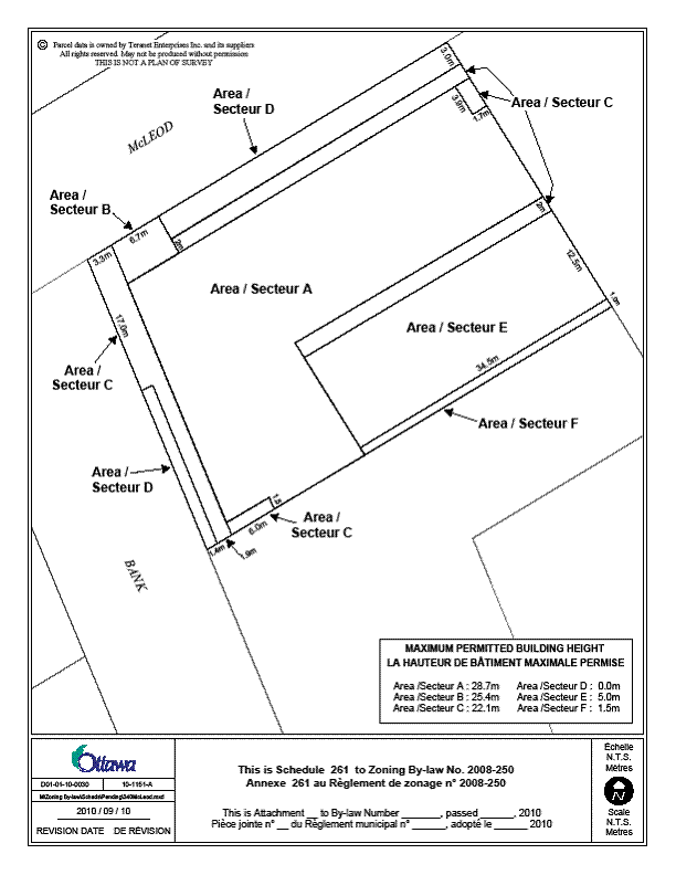
Document 3 Schedule xxx
Document 4 Consultation Details
DISPOSITION
City Clerk and Solicitor Department, Legislative Services to notify the owner, applicant, OttawaScene.com, 174 Colonnade Road, Unit #33, Ottawa, ON K2E 7J5, Ghislain Lamarche, Program Manager, Assessment, Financial Services Branch (Mail Code: 26-76) of City Council’s decision.
Planning and Growth Management to prepare the implementing by-law, forward to Legal Services and undertake the statutory notification.
Legal Services to forward the implementing by-law to City Council.
LOCATION MAP DOCUMENT 1
DETAILS OF RECOMMENDED ZONING DOCUMENT 2
Proposed Changes to Zoning By-law 2008-250
1. Amend the zoning of the subject lands from TM H(19) to TM [xxxx] Sxxx;
2. Add a new exception TM[xxxx] Sxxx and provisions to Section 239 with provisions similar in effect to the following:
a. clause 197(1)(b) only applies to a building wall facing Bank Street;
b. subclause 197(3)(d)(i) does not apply;
c. clause 197(3)(e) and subclause 197(3)(g)(ii) do not apply, and maximum permitted building heights are as shown on Schedule xxx;
d. clause 197(4)(d) does not apply, and the maximum front yard setback applies only to any part of a building below 15 metres;
e. despite Table 65 (6)(b), for an uncovered balcony, the maximum size of projection is 2m, and the maximum extent of projection is 0m from a lot line;
f. the maximum building heights specified on Schedule xxx do not apply to projections into required yards permitted in Section 65;
g. sub-clause 102(2)(b)(ii) does not apply and the minimum required visitor parking spaces for the balance of the dwelling units over 12 dwelling units is 0.1 spaces per dwelling unit; and
h. parking spaces are not required for any non-residential use that has a gross floor area of less than 700 m2 and is located on the ground floor of a building.
3. Add to Part 17 the schedule as shown in Document 3 as Schedule xxx.
SCHEDULE xxx REVISED DOCUMENT 3
CONSULTATION DETAILS DOCUMENT
4
NOTIFICATION AND CONSULTATION PROCESS
Notification and public consultation was undertaken in accordance with the Public Notification and Public Consultation Policy approved by City Council for Zoning By-law Amendments. There were 12 area residents who submitted comments, with two in favour, and 10 with concerns. A summary of the comments and staff responses are included below.
SUMMARY OF PUBLIC INPUT
Comment:
Reduced setbacks an issue. There is a need for more room for greenspace.
Staff Response:
The current TM zone permits a zero metre setback from the front lot line (Bank Street). The reduced setbacks are required for portions of the building above the second storey and above the fourth storey, as well as to the rear podium. There will still, in effect, be the same setback at ground level. Additional landscaping and street trees are proposed along McLeod Street.
Comment:
Existing height should be kept (6 storeys). Two mid-rise buildings on same corner is too much, especially when not downtown. Bank Street is not of this scale. The additional height will affect surrounding properties in terms of light, breeze, view, and density. The reason for limiting buildings along Bank Street to 19 metres/6 storeys is to respect heritage rules and to avoid changes in the overall feel of the street and neighbourhood. The danger is that, over time, the rules become meaningless and this stretch of Bank becomes a ‘tunnel’, like so many of the downtown streets are. McLeod Street is relatively narrow. If another 9-story building is constructed across the street from the 9-story building under construction, McLeod will be dark and devoid of life.
Staff Response:
The proposal includes step-backs above the seventh storey which reduces the impacts on aesthetics, scale, views, and microclimate. The proposed density is encouraged in areas along major transit corridors and in proximity to the central area. Further consideration of building height is included in the Discussion section above.
Comment:
The retail and visitor parking reductions will affect the neighbourhood as street parking is scarce and there are no plans for public parking. This plot of land is currently a parking lot so we need more parking, not less. The current parking lot on this site is usually full. There is illegal parking in private parking lots.
Staff response:
Rationale for reducing the retail and visitor parking requirements is included in the Discussion section above. The Official Plan seeks to reduce the number of surface parking lots in the inner area through redevelopment, and this proposal satisfies that goal. The existing parking lot is used primarily during business hours, which is a different time of peak use than visitor parking. Although it is recognized that parking conflicts may exist in private parking lots, the City has little control over enforcement of parking on private lands.
Comment:
Bike parking should not be reduced but should be increased.
Staff response:
The original proposal sought a reduction in bicycle parking. However, the proposal has since been revised to include additional bicycle parking, so no reduction from the Zoning By-law requirements are necessary.
|
EXTRACT OF draft Minutes 82 4 october 2010 |
|
extrait de l’Ébauche Du ProcÈs-verbal 82 LE 4 octobre 2010 |
ACS2010-ICS- PGM-0173 SOMERSET (14)
(This matter is Subject to Bill 51)
David Gladstone spoke with respect to this item, and the related heritage alteration application for the site. He generally felt the respect for the various policies in the staff report was notable. He suggested there should be a link between the objectives of this project and the Mid-Centretown Community Design Plan (CDP.) He also would have preferred to have a staff presentation on the record given it was a fairly significant and central site.
Nathalie Hughes was present representing the applicant in support of the application.
The Chair noted that there was a technical amendment from staff to replace Document 3 with a revised schedule. Kalle Hakala, Planner, confirmed that the minor changes were required as a result of receiving revised dimensions from the architect. The revised schedule was circulated to all members of Committee, and is included in the report to Council.
Moved by Councillor G. Hunter
BE IT RESOLVED THAT Document 3 of the staff report be replaced by a revised Schedule xxx
CARRIED
That the Planning and Environment Committee recommend Council approve an amendment to Zoning By-law 2008-250 to change the zoning of part of 340 McLeod Street from TM H(19.0) (Traditional Mainstreet, Height 19.0 metres) to TM [xxxx] Sxxx (Traditional Mainstreet, Exception xxxx, Schedule xxx), as detailed in Document 2, and shown in revised Document 3.
CARRIED, as amended