|
2. COMPREHENSIVE
ZONING BY-LAW 2008-250 – RÈGLEMENT
DE ZONAGE GÉNÉRAL 2008-250 : ANOMALIES |
PLANNING AND ENVIRONMENT COMMITTEE RECOMMENDATIONs AS AMENDED
1.
That Council approve the amendments
recommended in Column 3 of Documents 1 and 3 to correct anomalies in Zoning
By-law 2008-250; as amended by the following:
Amend
Column III of Document 1, regarding Section 197 (10) – Traditional Mainstreet
Zone, to 1) add a comma after the first use of the word “lot”, and a second
comma after the second use of the word “lot” in the first sentence; 2)
immediately following the word “block”, add the wording: “, or on a lot on the
opposite side of the public street on which the use requiring the parking is
located”; and 3) to delete the second sentence in its entirety, so that the
clause would now read:
“Despite any requirements to the contrary,
parking for a use required on one lot, may be located on another lot, but must
be in the same city block, or on a lot on the opposite side of the public
street on which the use requiring the parking is located.”
And that there be no further notice pursuant to
Section 34 (17) of the Planning Act.
AGRICULTURE AND RURAL AFFAIRS
COMMITTEE recommendations
As amended
2. That Council approve the amendments recommended in Column 3
of Documents 2 and 3, to correct anomalies in Zoning By-law 2008-250, as
amended by the following:
That report number ACS2010-ICS-PGM-0192 be amended by:
1) Amending Column III of
Document 2, regarding the Item entitled “Lands along Armitage Avenue;
Registered Plan 418”, by replacing all of the text in Column III with the
following text:
“Amend the Zoning Map to rezone the
subject lands as shown in Document 4 as follows:
Area A from RR15 [343r] to RR15
[xxxr];
Area B from RR11 [343r] to RR11
[xxxr];
Area C from RR11[343r] to RR11
[xxyr];
Area D from RR5 [343r] to RR11
[xxyr];
Area E from RR5 [343r] to RR5 [xxxr];
and,
Area F from RR5 [343r] to RR13 [343r].
Add the following new Exceptions and
provisions to Section 240 – Rural Exceptions:
a) Exception
[xxxr] includes the following provisions:
·
minimum lot width 15 m
·
minimum lot area 1000 m2
·
minimum interior side yard 3m
·
despite the definition of lot width in Section 54, lot
width is the distance between the side lot lines measured along the front lot
line
b) Exception [xxyr]includes the following provisions:
·
minimum lot width 9 m
·
minimum lot area 900 m2
·
despite the definition of lot width in Section 54, lot
width is the distance between the side lot lines measured along the front lot
line”
2) Replace the Location Map/Zoning Key Plan map for Armitage
Avenue in Document 4 with the attached Location Map/Zoning Key Plan, and;
That there be no further notice
pursuant to Section 34 (17) of the Planning Act.
RECOMMANDATIONS MODIFIÉES DU COMITÉ DE L’URBANISME ET
DE L’ENVIRONNEMENT
1. Que
le Conseil approuve les modifications recommandées dans la colonne 3 des
documents 1 et 3 afin de corriger des anomalies dans le Règlement de zonage no 2008-250, modifié de la façon suivante :
Modifie la colonne III du document 1, concernant le paragraphe 197 (10)
– Zone de rue principale traditionnelle, afin (1) d’ajouter une virgule après
la première occurrence du mot « lot »
et une seconde virgule après la seconde occurrence du mot « lot » à la première phrase; (2)
d’ajouter les mots suivants, immédiatement après le mot « block »: « , or on a lot on the opposite side of the
public street on which the use requiring the parking is located »; et
(3) de supprimer la deuxième phrase au complet, de façon que la clause se lise
maintenant comme suit :
« Despite
any requirements to the contrary, parking for a use required on one lot, may be
located on another lot, but must be in the same city block, or on a lot on the
opposite side of the public street on which the use requiring the parking is
located. »
Qu’aucun autre avis
ne soit donné, conformément au paragraphe 34 (17) de la Loi sur l’aménagement du territoire.
RECOMMANDATIONS MODIFIÉES DU COMITÉ DE L’AGRICULTURE
ET DES AFFAIRES RURALES
2. Que
le Conseil approuve les modifications recommandées à la colonne 3 des documents
2 et 3, afin de corriger des anomalies contenues dans le Règlement 2008-250 sur
le zonage, modifié de la manière suivante :
Que le rapport numéro ACS2010-ICS-PGM-0192 soit modifié par :
1) La modification de la colonne III du
document 2, concernant l’élément intitulé Lands along Armitage Avenue; Registered Plan 418 (Terrains situés le long de l’avenue Armitage; plan enregistré
418), soit le remplacement de la totalité du texte de la colonne III par le
texte suivant :
« Modifier la carte de zonage de façon à changer le zonage des
terrains en cause, illustrés au document 4, de la façon suivante :
Secteur A, de RR15
[343r] à RR15 [xxxr];
Secteur B, de RR11
[343r] à RR11 [xxxr];
Secteur C, de RR11[343r]
à RR11 [xxyr];
Secteur D, de RR5
[343r] à RR11 [xxyr];
Secteur E, de RR5
[343r] à RR5 [xxxr];
Secteur F, de RR5
[343r] à RR13 [343r].
Ajouter les nouvelles exceptions et dispositions suivantes à
l’article 240 – Exceptions rurales :
a) L’exception
[xxxr] comprend les dispositions suivantes :
·
Largeur
minimale de lot : 15 m
·
Superficie
minimale de lot : 1 000 m2
·
Retrait
minimal de cour latérale intérieure : 3 m
·
Malgré la définition
contenue à l’article 54, la largeur de lot est la distance entre les lignes de
lot latérales mesurée le long de la ligne de lot avant
b) l’exception [xxyr] comprend les
dispositions suivantes :
·
Largeur
minimale de lot : 9 m
·
Superficie
minimale de lot : 900 m2
·
Malgré la définition
contenue à l’article 54, la largeur de lot est la distance entre les lignes de
lot latérales mesurée le long de la ligne de lot avant. »
2) Remplacer le plan de situation/plan
repère de zonage pour l’avenue Armitage contenu dans le document 4 par le plan
de situation/plan repère de zonage ci-annexé;
Qu’aucun autre avis ne soit donné, conformément au
paragraphe 34 (17) de la Loi sur l’aménagement
du territoire.
Documentation
1. Deputy City Manager’s Report,
Infrastructure Services and Community Sustainability dated 29 October 2010
(ACS2010-ICS-PGM-0192).
2. Extract of Draft PEC Minute, 16
November 2010.
3. Extract of Draft ARAC Minute, 18
November 2010.
Report
to/Rapport au :
Agriculture and Rural Affairs Committee
Comité de l'agriculture et des affaires rurales
and / et au
Planning and Environment Committee
Comité de l'urbanisme et de l'environnement
and Council / et au Conseil
29 October 2010 / le 29 octobre 2010
Submitted by/Soumis par : Nancy Schepers, Deputy City
Manager, Directrice municipale adjointe, Infrastructure Services and Community
Sustainability, Services d’infrastructure et Viabilité des collectivités
Contact Person/Personne-ressource : Richard Kilstrom, Manager/Gestionnaire, Policy Development and Urban Design/Élaboration de la politique et conception urbaine, Planning and Growth Management/Urbanisme et Gestion de la croissance Élaboration de la politique et conception urbaine
(613)
580-2424 x22653, Richard.Kilstrom@ottawa.ca
SUBJECT:
|
COmprehensive Zoning By-law 2008-250 –
anomalies and minor corrections – fourth quarter 2010 |
|
|
|
OBJET :
|
RÈGLEMENT
DE ZONAGE GÉNÉRAL 2008-250 : ANOMALIES ET CORRECTIONS MINEURES –QUATRiÈme TRIMESTRE
2010 |
REPORT RECOMMENDATIONS
1. That
Planning and Environment Committee recommend that Council approve the
amendments recommended in Column 3 of Documents 1 and 3 to correct anomalies in
Zoning By-law 2008-250; and
2. That
Agriculture and Rural Affairs Committee recommend that Council approve the
amendments recommended in Column 3 of Documents 2 and 3, to correct anomalies
in Zoning By-law 2008-250.
RECOMMANDATIONS DU RAPPORT
1.
Que le Comité de l’urbanisme et de
l’environnement recommande au Conseil d’approuver les modifications
recommandées dans la colonne 3 des documents 1 et 3 afin de corriger des
anomalies dans le Règlement de zonage no 2008-250;
2.
Que le Comité de l’agriculture et
des affaires rurales recommande au Conseil d’approuver les modifications
recommandées dans la colonne 3 des documents 2 et 3 afin de corriger des
anomalies dans le Règlement de zonage no 2008-250.
BACKGROUND
On June 25, 2008 City Council adopted the new Comprehensive Zoning By-law 2008-250 that affects all properties within Ottawa. By-law 2008-250 replaces the 36 Zoning By-laws of the former municipalities that were amalgamated in 2001. Since the adoption of the Zoning By-law, staff have been identifying anomalies that require correction, and reports to correct the anomalies are being forwarded to Committee and Council on a regular basis.
DISCUSSION
Since the adoption of the Zoning By-law 2008-250, staff have monitored the new by-law and identified certain anomalies that are being recommended for correction. This report details recommended amendments to correct a number of the identified anomalies in both the urban and rural areas of the city. Document 1 provides staff recommendations to Planning and Environment Committee on the anomalies in the urban area, Document 2 provides staff recommendations to Agriculture and Rural Affairs Committee on the anomalies in the rural area, and Document 3 contains staff recommendations to both Committees on anomalies to general provisions affecting urban and rural lands. Document 4 includes those zoning maps pertinent to site- or area-specific rezonings.
The amendments are intended to correct mapping and text reference errors in the implementation of Council-approved changes that are not accurately reflected in the Comprehensive Zoning By-law.
RURAL IMPLICATIONS
N/A
CONSULTATION
Notice of the public meeting to deal with these anomalies and corrections was provided in The Citizen and Le Droit, with a listing of the addresses and provisions subject to correction. As well, interested parties have been notified by individual mail.
COMMENTS BY THE WARD
COUNCILLOR(S)
N/A
LEGAL/RISK MANAGEMENT IMPLICATIONS
These changes are of a routine nature to correct anomalies and do not have any legal/risk management implications.
CITY STRATEGIC PLAN
N/A
TECHNICAL IMPLICATIONS
N/A
FINANCIAL IMPLICATIONS
There are no direct financial implications associated with this report.
SUPPORTING DOCUMENTATION
Document 1 List of Anomalies and Modifications to Zoning By-law 2008-250 for consideration by Planning and Environment Committee
Document 2 List of Anomalies and Modifications to Zoning By-law 2008-250 for consideration by Agriculture and Rural Affairs Committee
Document 3 List of Anomalies and modifications to Zoning By-law 2008-250 for consideration by both Planning and Environment Committee and Agriculture and Rural Affairs Committee
Document 4 Location Maps
DISPOSITION
Planning and Growth Management Department to prepare the implementing by-law and forward it to Legal Services who will then forward the by-law to City Council.
REVISED DOCUMENT 1
Amended by PEC (16/11/2010) at Section 197(10),
Column 3
LIST OF ANOMALIES AND MODIFICATIONS TO ZONING
BY-LAW 2008-250 FOR CONSIDERATION BY
PLANNING AND ENVIRONMENT COMMITTEE
|
Item |
Objective of Amendment |
Proposed Amendment |
|
Zoning Map
Corrections |
||
|
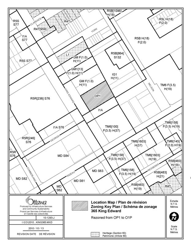
365 King Edward Avenue Ward 12 |
The zone code on the Zoning Map incorrectly zones this site
as OP1 – the correct code is O1P and should replace the incorrect code. |
Amend the Zoning Map, to rezone 365 King Edward to O1P, as
shown in document 4. |
|
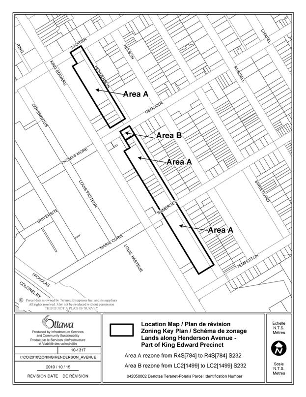
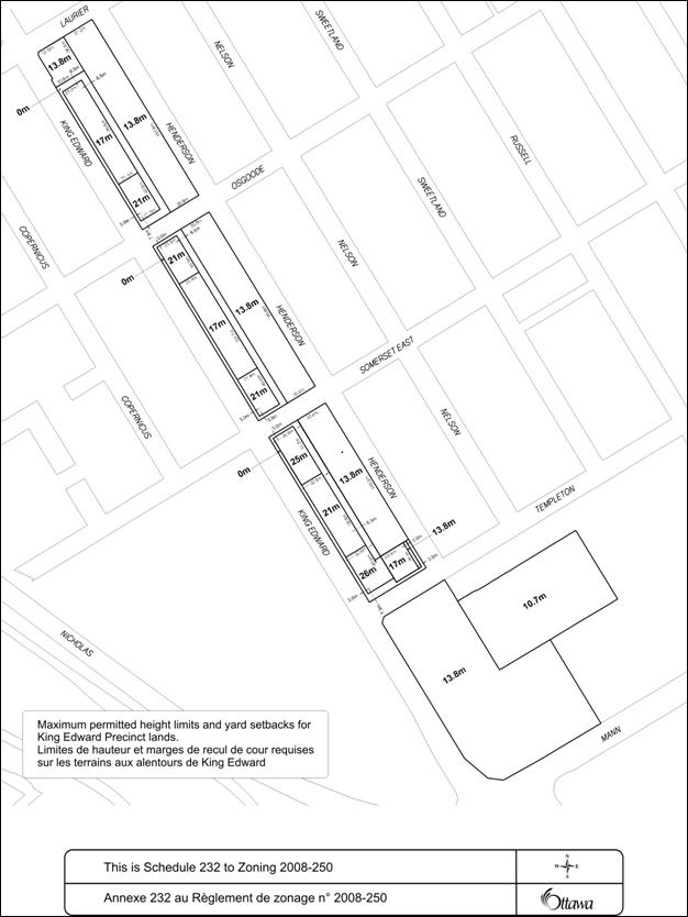
Lands along Henderson
Avenue, Part of the King Edward Avenue Precinct Schedule 232 Ward 12 |
In transferring the zoning
of these lands, as per By-law 2007-193, identification of the Schedule
associated with the site was not indicated on the Zoning Map, and as a
result, the maximum height of 13.8 m that applied to these lands, as
specified on the Schedule , as no longer required, in error. Reference to the Schedule (now numbered
232) should be added to the Zoning Map.
This will reinstate the maximum height on these lands. The former Schedule 269
included wording stating that the “existing zoning to remain…” and the
translated french wording should be deleted in Schedule 232 as this no longer
applies under the new zoning for the area.
Finally, the extension of a line delineating the boundary between the
lane at 0 metres and the lands permitted to a height of 25 metres should not
extend past the limit of the area zoned for 25 m. This extended line must be deleted so that the 0 m requirement
pertains to the whole of the lane. |
Amend the Zoning Map, to
rezone the lands along the west side of Henderson, between Templeton and
Laurier, from “R4S [784]” to “R4S [784]
S.232” and from “LC2 [1499]” to “LC2 [1499] S.232” Replace Schedule 232 with a
new Schedule 232, as shown in Document 4. |
|
425 Cloverdale Road Ward 13 |
These
lands were zoned residential (RD4) in the former Rockcliffe Park Zoning
By-law 2000-8 and contain existing residential uses They were inadvertently placed in the O1 -Parks
and Open Space zone. |
Amend the Zoning Map to rezone the
lands from O1 to R1BB [1258] and R1B [1259], as shown in Document 3. |
|
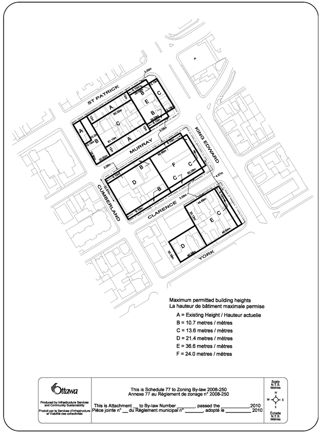
309 Cumberland, and 215 and
209 Clarence Street Schedule 77 Ward 12 |
The
zoning of a 6 metre strip of land, along the addresses noted in Column 1, did
not carry forward the required maximum height of 10.7 m under a previous
Ottawa Zoning By-law (No. Z-2K) into Ottawa Zoning By-law 93-98. This omission was then carried forward into
Zoning By-law 2008-250. The Schedule
should be amended to re-insert the maximum height of “B =10.7 metres” |
Replace Schedule 77 with a new Schedule 77, as shown in
Document 4. |
|
Text
Corrections |
||
|
1357 Baseline Road Ward 16 |
By-law No. 2010-148 removed the holding symbol from the Zoning Map
but should have also deleted the “h” symbol and provisions from Exception
[1711]. |
Delete “- h” from Column II of Exception [1711], and Delete provision 20 in Column V of Exception [1711] including
provisions 20(a) through (m) inclusive |
|
907 Eagleson Road Ward 23 |
The landscaping requirements
of site-specific Zoning By-law 2008-73 were not carried forward correctly
into the Zoning By-law 2008-250. First, it was intended that
the 15 m landscaping only be required for a use when abutting a Residential
(R) zone, and not a Development Reserve (DR) zone. Second, it was intended
that the landscaping required for the use abutting a residential zone, should
be a “vegetative buffer”. Third, it was required that
a minimum width landscaped buffer between any paved surface and not only a
parking lot, and a rear or interior side lot line of 5 m, should apply. |
Amend Section 239 – Urban Exception [1519], Column V, by deleting the
words “or a DR zone” in the second
bullet, and by specifying the requirement for soft landscaping, so that the
requirement would read: “minimum required width of soft landscaped area abutting
a residential zone: 15 m”. |
|
Part 6, Residential Zones –
R4 and R5 Endnotes: R4, Endnote 3 R4, Endnote 12 R5, Endnote 4 R5, Endnote 5 |
These Endnotes are unclear
and need to be restructured and reworded for purposes of clarity as there
have been numerous difficulties in interpreting these requirements. In addition, in translating the zoning
requirements, there was some confusion as to how to apply the rear yard
setback. In former zoning by-laws,
either the setback was calculated based on 25% of the lot depth, which
equates to 7.5m in the case of a typical lot with a lot depth of 30 m, or other
zoning by-laws established a standard 7.5m.
In these cases, the zoning by-law retains both the percentage as well
as the intent of the rule not exceeding the former 7.5 m standard in those
areas affected by these Endnotes. Further, the intent where a
rear lot line abuts an interior side lot line, is to have the rear yard
setback match that of the abutting interior yard, so that properties that
abut in this manner will have narrower side yards set back from the front lot
line that increase after 21m so as to increase the privacy backyard
space. This does not apply in the case
of the R5 Endnotes, as the high density nature of the R5 should result in a
reasonable rear yard setback of 25% of the lot depth, but need not exceed
7.5m. |
Amend
Part 6, R4, Endnote 3, R4, Endnote 12, R5, Endnote
4, and R5, Endnote 5 to replace the current wording with the revised wording in table format
to be added within the Endnote Tables of the R4 and R5: R4,
Endnote 3: Interior Side Yard Setback For any part of a
building located within 21 m of a front lot line the minimum required
interior side yard setback is: - where the
building wall is equal to or less than 11 m in height: 1.5 m; - where the
building wall is greater than 11 m in height: 2.5 m; - where the
building contains an apartment dwelling, low rise or stacked dwelling and the
side lot line abuts a residential subzone that does not permit that dwelling
type: 3 m and that yard must be landscaped; In all other
circumstances the minimum required interior side yard setback is 6 m. Rear Yard Setback The minimum
required rear yard setback is equal to 25% of the lot depth but need not
exceed 7.5 m. Notwithstanding the foregoing, where the rear lot line abuts
the interior side lot line of an abutting lot, the minimum required rear yard
setback must be the same as the required interior side yard setback of the
abutting lot along each point of the shared lot line. R4,
Endnote 12 Interior Side Yard Setback For any part of a
building located within 21 m of a front lot line the minimum required
interior side yard setback is: - where the
building wall is equal to or less than 11 m in height: 1.5 m; - where the
building wall is greater than 11 m in height: 3 m; In all other
circumstances the minimum required interior side yard setback is 6 m. Rear Yard Setback The minimum
required rear yard is 6 m. Notwithstanding the foregoing, where the rear lot
line abuts the interior side lot line of an abutting lot, the minimum
required rear yard setback must be the same as the required interior side
yard setback of the abutting lot along each point of the shared lot line. R5,
Endnote 4 Interior Side Yard
Setback Where a side lot line abuts a lot in an R1,
R2, R3 or R4 zone the minimum required interior side yard setback is 7.5 m. In all other circumstances for any part of a building the minimum
required interior side yard setback: - if located
within 21 m of the front lot line: 1.5 m - if located
further than 21 m from the front lot line: 6 m Rear Yard Setback The minimum required rear yard is 25% of the lot depth, but need not exceed 7.5 m. R5,
Endnote 5 Interior Side Yard Setback For any part of a
building located within 21 m of a front lot line the minimum required
interior side yard setback is: - where the building
wall is equal to or less than 11 m in height: 1.5 m; - where the
building wall is greater than 11 m in height: 2.5 m; - where the
building contains an apartment dwelling, low rise or stacked dwelling and the
side lot line abuts a residential subzone that does not permit that dwelling
type: 3 m; In all other
circumstances, the minimum required interior side yard is 6 m. Rear Yard Setback The minimum
required rear yard setback is equal to 25% of the lot depth but need not
exceed 7.5 m. |
|
Section 188 (6) (i) –
General Mixed Use Zone |
Clause (i) of Subsection
188 (6), specifies that required and provided parking may be used for
additional parking for the sports arena, but identifies the incorrect zoning
of the arena site. |
Amend
Section 188 (6) (i) to replace the reference to the O1 [313] zone with “L2
[359]”. |
|
Section 197 (10) - Traditional Mainstreet Zone |
The wording of this subsection has caused
confusion as to which “use” is being referred to in reference to being
“accommodated”: “Despite any requirements to the contrary, parking may be
located on another lot accommodating the use…” It should be reworded to
reflect the intent which is, to permit parking spaces required by a use on
one lot, to be permitted on another lot. In addition, interpretation difficulties have
arisen with respect to the words “city block”. It is recommended that the phrase be
defined for purposes of this subsection. |
Amend Subsection 197 (10)
to read: “(10) Despite any requirements to the contrary, parking for a use required on
one lot, may be located on
another lot but must be in the same city block, or on a lot on the opposite side of the public street on which
the use requiring the parking is located.” |
|
Subsection 206 (7)
Industrial Business Park Zone |
A park is listed as both an
as-of-right permitted use and as a use subject to conditions. Given its status as an as-of-right use, it
is recommended that the conditional use and its condition be deleted. |
Amend Subsection 206 (7) to
delete clause (b), paragraph (iv), and to delete “and” following paragraph
(iii); and delete the listed conditional use “park” noted under clause 206
(7) (b) (iv). |
REVISED DOCUMENT 2
Amended by ARAC (18/11/2010) at Column
3, Lands along Armitage Avenue
LIST OF ANOMALIES AND MODIFICATIONS TO ZONING
BY-LAW 2008-250 FOR CONSIDERATION BY
AGRICULTURAL AND RURAL AFFAIRS COMMITTEE
|
Item |
Objective of Amendment |
Proposed Amendment |
|
Zoning Map
and Text Corrections |
||
|
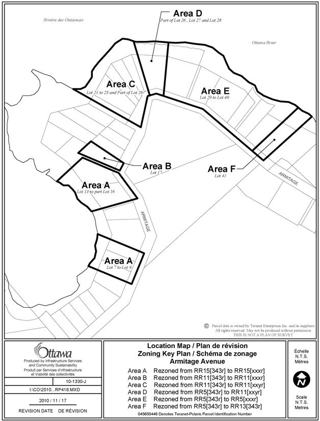
Lands along Armitage
Avenue; Registered Plan 418 Ward 5 |
In former West Carleton Zoning By-law, undersized lots were permitted, and considered to be complying regardless of their lot widths or lot areas. This provision was carried forward and applied to various zones, but was not applied to RR Zones. The RR Zones were created to reflect existing, mostly linear, residential settlement areas within the rural area. The majority of the lots on Registered Plan 418 are undersized, and have been zoned in various RR subzones that do not reflect their sizes. It is recommended that the lots, identified on Document 3, be rezoned to reflect their sizes, and thus be made conforming. Exception zones are
proposed to recognize the distinct lot sizes, and are to carry forward the
regulations of the current exception [343r] |
Amend the Zoning
Map to rezone the subject lands as shown in Document 4 as follows: Area A from RR15 [343r] to RR15 [xxxr]; Area B from RR11 [343r] to RR11 [xxxr]; Area C from RR11[343r] to RR11 [xxyr]; Area D from RR5 [343r] to RR11 [xxyr]; Area E from RR5 [343r] to RR5 [xxxr]; and, Area F from RR5 [343r] to RR13 [343r]. Add the
following new Exceptions and provisions to Section 240 – Rural Exceptions: a) Exception
[xxxr] includes the following provisions: ·
minimum lot width 15 m ·
minimum lot area 1000 m2 ·
minimum interior side yard 3m ·
despite the definition of lot width in Section 54, lot
width is the distance between the side lot lines measured along the front lot
line b) Exception
[xxyr]includes the following provisions: ·
minimum lot width 9 m ·
minimum lot area 900 m2 · despite the definition of lot width in Section 54, lot width is the distance between the side lot lines measured along the front lot line”
|
|
5550 Buckles Street Ward 20 |
Site-specific Zoning By-law amendment 2005-470 was not
carried forward into Zoning By-law 2008-250 correctly and should be amended
accordingly. |
Amend the Zoning Map, to
rezone the affected lands, as shown in Document 3, by amending Area A from O1
to O1[xxxr] and Area B from V1I to V1I[xxxr] Amend Section 240, Rural
Exceptions, by creating a new exception [xxxr], as follows: -add “O1[xxxr] and
V1I[xxxr]” to Column II -add the following
provisions to Column V: “-a no-touch area of 15
metres from the Buckles Municipal Drain and Schell Branch, measured shoreward
from the edge of the average annual high water mark is required -a no-build area of 15
metres from the Buckles Municipal Drain and Schell Branch, measured shoreward
from the edge of the average annual high water mark is required - the no-touch area shall be an area left in its natural state and protected
from any human activity. -the no-build area shall be an area where
no buildings or structures of any kind, including
but not limited to residential dwellings, decks, gazebos, sheds, garages,
workshops, septic systems, wells, swimming pools, change houses, pump houses,
nor any structural landscaping of any kind are permitted. |
DOCUMENT 3
LIST OF ANOMALIES AND MODIFICATIONS TO ZONING
BY-LAW 2008-250 FOR CONSIDERATION BY BOTH PLANNING AND ENVIRONMENT COMMITTEE AND AGRICULTURAL AND RURAL AFFAIRS COMMITTEE
|
Item |
Objective of Amendment |
Proposed Amendment |
|
Zoning Text Corrections |
||
|
Section 54 – Definitions Heavy vehicle City-wide |
This definition was not clear in regards to whether a limousine would be considered a heavy vehicle. A review of the Highway Traffic Act indicated that a “commercial motor vehicle” includes a “bus”, and a “bus” is defined in the same Act to include all passenger motor vehicles with capacity for more than ten passengers. Thus, any limousine with a capacity greater than 10 passengers meets the Act’s definition of a “bus”, which is a type of commercial motor vehicle under the Act and a “heavy vehicle” under the Zoning By-law 2008-250. To clarify the term, it is recommended that reference to all passenger motor vehicles with large capacities, and not only buses, be added to the definition of heavy vehicle. |
Amend Section 54, Definitions, to add clarity to the term heavy
vehicle, by adding the following phrase, immediately following the word
“bus”: “and any other passenger motor vehicle with capacity for
more than ten passengers,” so that the term would now read: “Heavy vehicle means a commercial motor
vehicle as defined in the Highway Traffic Act, as amended or re-enacted from
time to time, including a bus and any other passenger motor vehicle with
capacity for more than ten passengers, fire apparatus, road-building machine
or farm vehicle as defined in that Act, and all other types of construction
equipment, but excludes a motor vehicle.” |
|
Section 135 – Through Lots
in Residential Zones, (including Village Residential Zones) City-wide |
The intent of the
regulations is to apply a front yard setback from both streets in the case
of a corner lot, so that both sides match the front yard setback off of each
street, thus retaining a constant setback or building wall. In the case of a through
corner lot, it would be appropriate to apply the same type of intent, while
recognizing that the lands abutting one of the three streets should function
as the corner side lot line, while the two that are essentially parallel,
would both be subject to front yard setbacks, to match those of abutting
properties along each street. |
Amend
Section 135 to revise the wording of the title, and revise the wording of
subsection (1), as well as delete and replace subsection (2) with a new (2),
as follows: Through Lots and Corner
Through Lots in Residential Zones (Section 135) “(1) In the case of a residentially-zoned through lot, or corner through lot, the minimum required front yard setback applies to both the front and rear lot lines, in accordance with the provisions of the Residential zone or zones in which such lot is located and the minimum required rear yard setback does not apply. (2)In the case of a corner through lot, the minimum required corner side yard setback applies to the street that is mostly perpendicular to the other two streets, in accordance with the provisions of the Residential zone or zones in which such lot is located.” |
REVISED
DOCUMENT 4
Amended
by ARAC (18/11/2010) at Map Re: Lands along Armitage Avenue
LIST OF SITE-SPECIFIC
LOCATION MAPS
|
Location Maps (attached) |
|
365 King Edward Avenue |
|
Lands along Henderson
Avenue, Part of the King Edward Avenue Precinct |
|
Schedule 232 |
|
425 Cloverdale Road |
|
Schedule 77 |
|
309 Cumberland Street, 215
and 209 Clarence Street |
|
Lands along Armitage
Avenue, R.P. 418 |
|
5550 Buckles Street |

REVISED
MAP (ARAC 18/11/2010)