|
1. ZONING – 800 MONTRÉAL ROAD
ZONAGE – 800, CHEMIN MONTRÉAL
|
Committee recommendation
(This matter is Subject to Bill 51)
That Council approve an amendment to Zoning By-law 2008-250 to change the zoning of 800 Montréal Road from AM5 (Arterial Mainstreet Subzone 5) to R4T [xxxx] (Residential Fourth Density Subzone T, Exception xxxx), AM5 [yyyy] (Arterial Mainstreet Subzone 5, Exception yyyy), AM5 [yyyy] Sxxx (Arterial Mainstreet Subzone 5, Exception yyyy, Schedule xxx), O1 (Parks and Open Space Zone); and adding a Heritage Overlay, as detailed in Document 2, and as shown in Documents 3 and 4.
Recommandation du comité
(Cette question est assujettie au Règlement 51)
Que le Conseil approuve une modification au Règlement de zonage général no 2008-250 en vue de changer le zonage du 800, chemin Montréal, de AM5 (Zone d’artère principale, sous-zone 5) à R4T [xxxx] (Zone résidentielle de densité 4, sous-zone T), à AM5 [yyyy] (Zone d’artère principale, sous-zone 5, avec exception yyyy), à AM5 [yyyy] Sxxx (Zone d’artère principale, sous-zone 5, avec exception yyyy, annexe xxx) et à O1 (Zone de parc et d’espace vert); et d’y ajouter une désignation patrimoniale, comme l’explique le document 2 et le montre les documents 3 et 4.
Documentation
1. Deputy City Manager's report, Infrastructure Services and Community Sustainability dated 20 December 2010 (ACS2011-ICS-PGM-0030).
2. Extract of Draft Planning Committee Minutes of 11 January 2011.
Report to/Rapport au :
Comité de l'urbanisme
and Council / et au Conseil
20 December 2010 / le 20 décembre 2010
Submitted by/Soumis par : Nancy Schepers, Deputy City Manager/Directrice municipale adjointe, Infrastructure Services and Community Sustainability/Services d’infrastructure et Viabilité des collectivités
Contact Person/Personne-ressource : Richard Kilstrom, Acting Manager/Gestionnaire intérimaire, Development Review-Urban Services, Inner Core/Examen des projets d'aménagement-Services urbains, Unité du Centre intérieur, Planning and Growth Management/Urbanisme et Gestion de la croissance
(613) 580-2424, 22379 Richard.Kilstrom@ottawa.ca
|
SUBJECT: |
|
|
|
|
|
OBJET : |
REPORT RECOMMENDATIONS
That the Planning Committee recommend Council approve an amendment to Zoning By-law 2008-250 to change the zoning of 800 Montreal Road from AM5 (Arterial Mainstreet Subzone 5) to R4T [xxxx] (Residential Fourth Density Subzone T, Exception xxxx), AM5 [yyyy] (Arterial Mainstreet Subzone 5, Exception yyyy), AM5 [yyyy] Sxxx (Arterial Mainstreet Subzone 5, Exception yyyy, Schedule xxx), O1 (Parks and Open Space Zone); and adding a Heritage Overlay, as detailed in Document 2, and as shown in Documents 3 and 4.
RECOMMANDATIONS DU RAPPORT
Que le Comité de l’urbanisme recommande au Conseil d’approuver une modification au Règlement de zonage général no 2008-250 en vue de changer le zonage du 800, chemin Montréal, de AM5 (Zone d’artère principale, sous-zone 5) à R4T [xxxx] (Zone résidentielle de densité 4, sous-zone T), à AM5 [yyyy] (Zone d’artère principale, sous-zone 5, avec exception yyyy), à AM5 [yyyy] Sxxx (Zone d’artère principale, sous-zone 5, avec exception yyyy, annexe xxx) et à O1 (Zone de parc et d’espace vert); et d’y ajouter une désignation patrimoniale, comme l’explique le document 2 et le montre les documents 3 et 4.
BACKGROUND
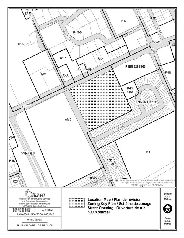
The subject property, 800 Montreal Road, is located on the south side of Montreal Road and the east side of Den Haag Drive, just west of Carson's Road. The 4.2‑hectare site is currently occupied by an existing two-storey building, while another building was recently demolished. A surface parking lot also exists to the west of the existing building. The site is characterized by clusters of vegetation, which are primarily located along the southern and eastern edges of the site and adjacent to the existing building, with grading that falls when moving away from Montreal Road toward the south. The site is surrounded by a range of uses, including the CMHC head office complex to the west, the Montfort Hospital complex to the northwest, mixed low-rise commercial and residential across Montreal Road to the north, an 11‑storey apartment building to the east, and townhouses along Carwood Circle to the southeast and south.
Development Proposal
The proposed development of the site includes five development blocks, which include a range of dwelling types and densities, as well as a public park and a new public street. The blocks consist of: multiple-attached (townhouse) dwellings (22 units), four-storey stacked dwellings (76 to 80 units), a six-eight storey retirement home (140 units), and six apartment buildings ranging from four to 12 storeys (355 to 410 units), all totalling between 600 to 637 units. Each of the blocks will be developed through separate Site Plan Control applications in the future, thus the number of units and mix is conceptual. The existing heritage building, formerly the head office and main laboratory of Forintek, Canada’s wood products research agency, is intended to be retained and incorporated into the retirement home.
The site is currently zoned as AM5 (Arterial Mainstreet - Subzone 5), which permits a range of commercial and residential uses. This zone permits a maximum building height of 25 metres on those portions of the site not directly abutting low- to medium-rise residential, where it reduces to a maximum height of 15 metres.
Purpose of Application
Amendments to the AM5 (Arterial Mainstreet – Subzone 5) zone are required in order for the development concept to proceed as currently proposed, including an additional permitted use, additional height on a portion of the site, as well as other changes required for consistency with the proposed development.
Proposed Zoning
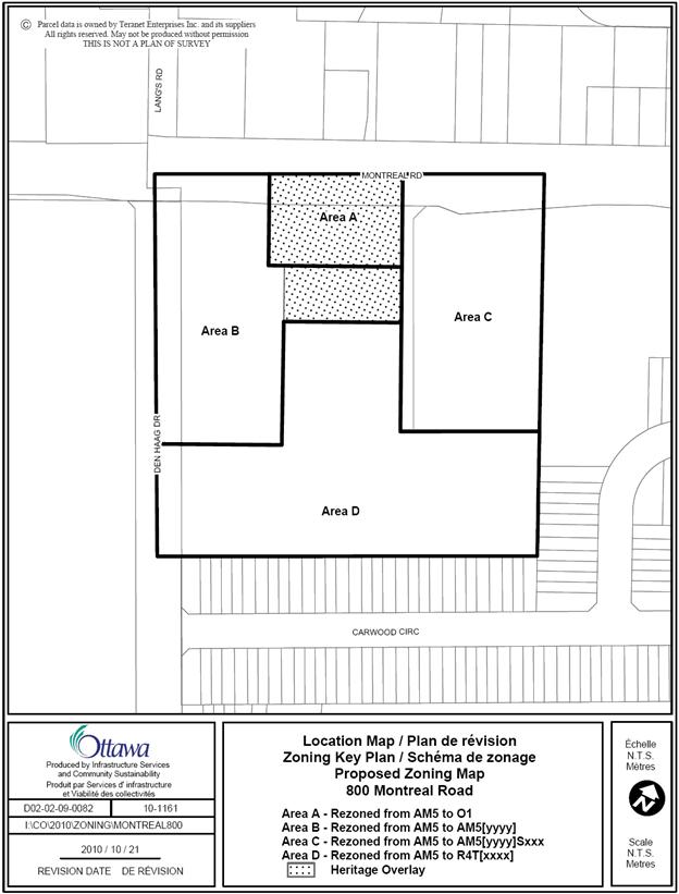
The proposed zoning will create an exception to the AM5 zone to add a retirement home as an additional permitted use, restrict automobile-oriented uses, increase the maximum building height from 25 metres to 40 metres on the portion of the site adjacent Montreal Road and establish design-oriented zoning provisions. A heritage overlay is proposed to be added for the existing heritage building on the site. The southern portion of the site is intended to be rezoned to R4T [xxxx] (Residential Fourth Density Subzone T, Exception xxxx) with exceptions to restrict certain building types, and to establish design-oriented zoning provisions. An O1 (Parks and Open Space) zone is proposed to reflect the location of the new public park. Details of the recommended zoning are included in Document 2.
Companion Applications
A concurrent Street Opening application (File No. D07-15-09-0002) is being considered to establish the new public street, which is proposed to connect from Den Haag Drive to Montreal Road and will provide access to the development blocks as well as the public park. In addition, Consent for Severance applications are currently being considered by the Committee of Adjustment to establish the development blocks and the public street (File Nos. D08-01-10/B-00070 to B-00075 and B-00294).
DISCUSSION
Planning Act and Provincial Policy Statement
Section 2 of the Planning Act outlines those land use matters that are of provincial interest, to which all City planning decisions shall have regard. The provincial interests that apply to this site include the appropriate location of growth and development and the promotion of development that is designed to be sustainable, to support public transit and to be oriented to pedestrians. In addition, the Planning Act requires that all City planning decisions be consistent with the Provincial Policy Statement (PPS), a document that provides further policies on matters of provincial interest related to land use development. The PPS policies indicate that there should be an appropriate mix of uses and range of housing types and densities which efficiently use land, resources, infrastructure and public service facilities, and support the use of alternative transportation modes and public transit.
The proposed zoning allows for a mix of residential and commercial uses, which will efficiently use land and contribute to a balanced community. The proposal includes a mix of housing types and densities. The site is located on an arterial road and transit priority corridor (Montreal Road), which provides excellent access to the site and is a focus for mixed-use development. The site is conveniently located to nearby residential and commercial areas to allow for access by pedestrians. Staff conclude that the proposal is consistent with the matters of provincial interest as outlined in the Planning Act and the PPS.
Official Plan
Strategic Directions
Section 2 of the Official Plan sets broad strategic directions to meet the challenge of managing growth, providing infrastructure, maintaining environmental integrity and creating liveable communities within Ottawa. To meet these challenges, polices are set out to pursue a mix of land uses, housing types and compact forms of development which in turn will enable the City to support a high-quality transit system and make better use of existing infrastructure and roads. The proposed development provides a mix of uses and housing types at densities that will support this overall goal.
Land Use Designation
The site is designated as Arterial Mainstreet on Schedule B of the Official Plan. Arterial Mainstreets intend to function as mixed-use corridors in order to sustain the surrounding community, transit system, and to provide a focus for the community. They intend to establish strong street edge with buildings that are human-scaled. The Arterial Mainstreet designation recognizes the importance of these sites in achieving a positive pedestrian environment and providing a lively mix of uses, and represents sites with significant opportunities for intensification. The Montreal Road Arterial Mainstreet has a minimum density target of 170 people plus jobs per net hectare.
The proposed development has a density of between 295 and 335 people and jobs per net hectare, thus is in conformity with the Official Plan targets. The proposed development achieves a more intense, yet human-scaled, built form in this part of the city and will contribute to supporting the public transit system and community services. The location of the proposed 12‑storey building, and thus the greatest density proposed on the site, is adjacent to Montreal Road, which supports the existing and planned transit system. The mix of housing types on the site fits in with the Arterial Mainstreet objectives. Therefore, the proposed development meets the intent of the Arterial Mainstreet designation.
Compatibility and Urban Design
Section 2.5.1 establishes design objectives which describes the vision for the form of the City’s built environment. These objectives are broadly stated and are applicable to all land use designations either at the city-wide level or on a site-specific basis. Design principles are further set out to describe how the City hopes to achieve the design objectives, with acknowledgment that all the design objectives may not be achieved or be achievable in all cases.
The proposed development is consistent with and implements the design objectives which speak to enhancing the sense of community, defining public and private spaces through development and having new development respect the character of existing areas. An enhanced sense of community is being achieved by infilling a large underdeveloped site and strengthening the urban fabric of the street both physically and functionally.
Staff are also proposing specific zoning provisions that require buildings to address the public streets and restrict the location of parking, thus establishing a strong street edge and pedestrian environment. For the lands that will remain within the AM zone, automobile-oriented uses, such as parking lots and drive-throughs will be prohibited.
The proposed development concept respects the character of the existing area by complementing the massing pattern, height, and character of the surrounding context. The proposed 12-storey building at the north-east of the site is located close to Montreal Road and adjacent to an existing high-rise building. Building heights transition lower moving away from Montreal Road toward the existing low-rise neighbourhood to the south.
Strategy for Parks and Leisure
Public and private spaces are being defined through the creation of a new public park, the location of which is in conformity with Section 2.5.4 – A Strategy for Parks and Leisure Areas of the City’s Official Plan. Section 2.5.4 provides direction on the location, establishment and design of parks.
Parks and leisure areas are to be linked to the Greenspace Network, identified in the Greenspace Master Plan, and developed in conjunction with other facilities such as schools and other institutions, federal open spaces and other public lands. The proposed park has been strategically located so that it combines open space in front of the heritage Forintek building (recommended by Federal Heritage Buildings Review Office guidelines) with a publicly accessible recreational space, thereby bringing people into the area that creates the building’s heritage setting.
Section 2.5.4 also states that Council will pursue targets for parks and leisure areas in the urban area in keeping with the objectives of the Greenspace Master Plan - Strategies for Ottawa’s Urban Greenspaces. These lands will include the parkland dedicated to the City under the Planning Act through the City’s Parkland Dedication By-law (Committee of Adjustment process). Any additional outstanding parkland dedication will be collected as cash in lieu of parkland through the site plan approval process once the blocks of lands are developed.
In addition, Section 2.5.4 requires that new Park and Leisure Areas provided in urban areas will have the following characteristics:
- Contribute to the equitable distribution of these areas within the community;
- Be easily accessible by foot or by bicycle from homes and linked to other greenspaces;
- Are visible from many vantage points within the community;
- Have significant street frontage, in proportion to their size, often fronting on two or more streets depending on their shape and function; and
- Designed to be engaging and useful spaces for people across a wide spectrum of age, socio-economic demographics and recreational interests.
The proposed park is located at the southwest corner of Montreal Road and the new proposed public street. The location of the park is accessible to residents of the area and is easily accessible by pedestrians or cyclists. The location of the park along Montreal Road provides visibility of the park from many different vantage points and provides a significant street frontage. The park will provide the residents of the new developments and existing developments a useful public space.
Section 4.11 and the Urban Design Guidelines provide further direction on design and compatible development. The Urban Design Guidelines for Arterial Mainstreets, Transit-oriented Development, and High-Rise Housing are applicable to this site. Amongst the considerations are built form, open space, transportation and parking, sunlight, and supporting neighbourhood services.
Transportation and Parking: The Community Transportation Study submitted with the application indicates that the proposed development will generate 234 vehicular trips in the afternoon peak hour, which will have minimal impact on the existing street network and Level of Service of surrounding intersections. The new public street will provide access to the individual development blocks. The proposed zoning will restrict the location of parking from being adjacent to public streets, in order to create more pedestrian-oriented streetscapes. In addition, the proposed zoning will reduce parking requirements such that parking will be provided at a rate consistent with parking rates in the surrounding areas to the north and west.
Built Form: Although the existing AM5 zone permits building heights up to eight storeys, other aspects of the built form of development are not specifically defined in the existing zoning. The proposed zoning requires buildings to be located close to the public street, and requires additional setbacks for the upper storeys of buildings, in order to create a more human-scaled environment and to reduce the visual impact of the 12-storey building.
Open Space: A new public park will be established along Montreal Road which will contribute to the active environment along this Arterial Mainstreet. The location of the park was determined to ensure access, preserve views to the heritage building, and to create a space that is well-defined by surrounding existing and proposed buildings. Requirements for the conveyance of the park will be furthered through the conditions of the Consent for Severance and Street Opening applications.
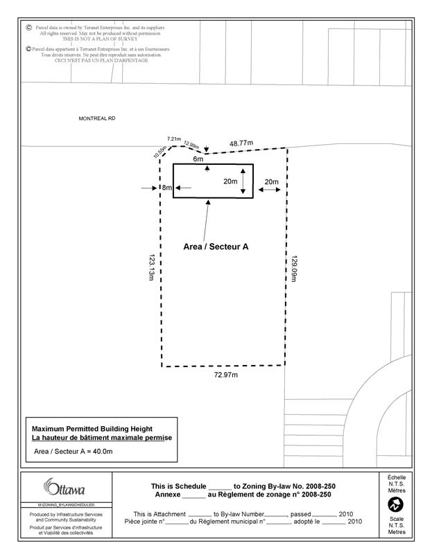
Sunlight: The 12-storey high-rise building will be located adjacent to Montreal Road at the north end of the site. The proposed six-metre setback for the upper storeys, combined with Montreal Road’s wide road allowance, ensure that there is substantial distance between the high-rise portion of the building and the existing development to the north, such that shadowing impacts are reduced. There is a 40-metre setback between the existing 11-storey building to the east and the proposed 12-storey building, which will allow natural light through and reduce shadow impacts. The sun/shadow study that was submitted with the application indicates that on the winter solstice (December 21) when the sun-angle is at its lowest, some properties on the north side of Montreal Road will experience short-term shadows for portions of the day. However, the overall impact is minor.
Supporting Neighbourhood Services: The proposed development concept includes a daycare, retirement home, and public park, which will provide services to the surrounding community. The addition of approximately 600 dwelling units to the area will increase transit usage, thereby providing an incentive for increased transit service in this area over time. The site is within walking distance to existing services and public parks.
Other design aspects, such as streetscape, building design, amenity area, and pedestrian and cycling amenities will be addressed through the Site Plan Control process.
Infrastructure
The Official Plan policies of Subsection 4.4 Water and Wastewater Servicing require adequate services for new development. The property is adequately served by water, storm and sanitary sewer lines to facilitate the proposed development permitted by the re-zoning.
Heritage Considerations
The existing building, formerly used by Forintek, is identified by the Federal Heritage Buildings Review Office as a Recognized Federal Heritage Building. The proposed development retains the existing building in accordance with the requirements of the federal agreement of purchase and sale and incorporates it into the design of the site. Views from Montreal Road have been ensured through the establishment of a public park in front of the building. In addition, staff recommend that a heritage overlay be included in the proposed zoning in order that its reuse be guided by the heritage provisions in the Zoning By-law.
Residential Zoning
The two development blocks at the south portion of the site that are intended for multiple-attached and stacked dwellings will not have any frontage onto Montreal Road after the creation of the new public street. To better reflect the form and type of development proposed, and to account for the lack of frontage on the Arterial Mainstreet, these two development blocks are intended to be rezoned to a R4T [xxxx] (Residential Fourth Density Subzone T, Exception xxxx). Since the development concept is considered to be an early iteration of what will eventually become a more defined site plan, and because the applicant will not be the party developing the property, but is actually selling blocks of land to other parties to develop, staff will pursue the final design, layout, parking arrangement, buffer areas and amenity space areas of the residential blocks of land with the future developers.
Site Plan Control
It is anticipated that each block will be individually developed and each will necessitate a Site Plan Control process. Site issues such as location of parking, noise attenuation, servicing, landscaping, buffering, amenity space design, microclimate impacts and stormwater management will be addressed through the Site Plan Control process. The lands front onto an Arterial Mainstreet and as such are within a Design Priority Area. Each of the blocks will be required to go through the Urban Design Review process, which will further enhance staff’s ability to achieve the most desirable built form and building design.
Summary
The proposed development supports the direction of the Planning Act and Provincial Policy Statement by creating new development at densities and locations that efficiently uses land, existing infrastructure, and supports alternative transportation. It represents an appropriate form of intensification, and is in conformity with the policies for the Arterial Mainstreet designation. Staff are satisfied that the compatibility, design and transportation aspects of the site have been adequately considered in light of the relevant Official Plan policies and Urban Design Guidelines. The proposed Zoning By-law amendment conforms with the general intent of the Official Plan and existing zoning on the site, and as such, staff recommend approval of the proposed zoning.
ENVIRONMENTAL IMPLICATIONS
Phase I and Phase II Environmental Site Assessments (ESA) were submitted with the application, and a Record of Site Condition has been filed with the Ministry of the Environment. Certain standard conditions will be included in the Site Plan Control approval based on the recommendations of the ESAs.
The Rideau Valley Conservation Authority and City staff have indicated that there are no issues from an environmental point of view regarding the proposed Zoning By-law Amendment.
RURAL IMPLICATIONS
N/A
CONSULTATION
Notice of this application was carried out in accordance with the City's Public Notification and Consultation Policy. Details of the public consultation can be found in Document 5.
COMMENTS BY THE WARD COUNCILLOR(S)
Councillor Clark is aware of the application and has no concerns.
LEGAL/RISK MANAGEMENT IMPLICATIONS
Should this matter be appealed to the Ontario Municipal Board, it is anticipated that a three-day hearing would result. The City would be represented by staff witnesses if the above recommendation is adopted. Should the application be refused, reasons must be provided. On appeal, an outside planner would need to be retained at an estimated cost of $25,000.
CITY STRATEGIC PLAN
The proposed development and planning applications align with the City Strategic Plan in that it respects the existing urban fabric, neighbourhood form, and the limits of existing hard services so that new growth is integrated seamlessly with established communities; creates a walking, transit, and cycling-oriented community; and contributes toward achieving a 30-per cent modal split by 2021.
TECHNICAL IMPLICATIONS
FINANCIAL IMPLICATIONS
Should this matter be appealed to the Ontario Municipal Board, it is anticipated that a three-day hearing would result. The City would be represented by staff witnesses if the above recommendation is adopted. Should the application be refused, reasons must be provided. On appeal, an outside planner would need to be retained at an estimated cost of $25,000.
APPLICATION PROCESS TIMELINE STATUS
The application was not processed by the "On Time Decision Date" established for the processing of Zoning By-law amendments due to the need to resolve issues with park location and community design.
SUPPORTING DOCUMENTATION
Document 1 Location Map
Document 2 Details of Recommended Zoning
Document 3 Proposed Zoning Map
Document 4 Schedule xxx
Document 5 Consultation Details
DISPOSITION
City Clerk and Solicitor Department, Legislative Services to notify the owner, applicant, OttawaScene.com, 174 Colonnade Road, Unit #33, Ottawa, ON K2E 7J5, Ghislain Lamarche, Program Manager, Assessment, Financial Services Branch (Mail Code: 26-76) of City Council’s decision.
Planning and Growth Management to prepare the implementing by-law, forward to Legal Services and undertake the statutory notification.
Legal Services to forward the implementing by-law to City Council.
LOCATION MAP DOCUMENT 1
DETAILS OF RECOMMENDED ZONING DOCUMENT 2
Proposed Changes to the Comprehensive Zoning By-law
1. The Zoning Map of City of Ottawa Zoning By-law 2008-250 is amended by changing the zoning of the lands known municipally as 800 Montreal Road from AM5 (Arterial Mainstreet Subzone 5) to R4T [xxxx] (Residential Fourth Density Subzone T), AM5 [yyyy] (Arterial Mainstreet Subzone 5, Exception yyyy), AM5 [yyyy] Sxxx (Arterial Mainstreet Subzone 5, Exception yyyy, Schedule xxx), O1 (Public Open Space Subzone 1); and adding a Heritage Overlay, as shown on Document 3.
2. Add a new exception [yyyy] and provisions to Section 239 as follows:
Column III: Additional land uses permitted:
retirement home
Column IV: Land used prohibited
car wash
drive-through facility
stacked dwelling
parking lot as a principal use
service and repair shop
Column V: Provisions
a. Minimum front and corner side yard setback for any part of a building above 11m: 6m
b. Maximum required front and corner side yard setback for any part of a building wall 11m or less in height:
i. Montreal Road: 25m from centreline of Montreal Road
ii. Other streets: 3.0m from street lot line
c. The wall at grade facing a public street shall have 50% of its facade comprised of windows and entrances and, in the case of a corner lot, the entrance may be in an angle at corner walls facing a street intersection;
d. Despite Schedule 1, for the purpose of calculating all required parking the lands zoned AM5[yyyy] and AM5[yyyy] S262 shall be subject to the rates set out in Section 101, Table 101, Column III for Area B on Schedule 1.
3. Add new exception [xxxx] and provisions to Section 239 as follows:
Column IV: Land Uses Prohibited
detached, linked-detached, semi-detached, and duplex dwellings
Column V: Provisions
a. Any yard abutting a public pedestrian pathway shall be considered a corner side yard
b. Minimum front and corner side yard setback: 2.5m
c. Minimum interior side yard setback:
i. Abutting an R1, R2, R3, or R4 zone: 7.5m
ii. All other cases: 4.5m
d. Minimum rear yard setback: 5.5m
e. The front doors of all dwelling units must be located in a wall directly facing either a street or pedestrian pathway.
f. Exterior parking spaces and aisles leading to a parking space must not be located
i. closer than 12.0 metres to a dwelling
ii. in any required yard, or in a provided front or corner side yard.
g. Despite Schedule 1, for the purpose of calculating all required parking the lands zoned R4T[xxxx] shall be subject to the rates set out in Section 101, Table 101, Column III for Area B on Schedule 1
4. Add to Part 17 the schedule as shown in Document 4 as Schedule xxx.
PROPOSED ZONING MAP DOCUMENT 3
SCHEDULE xxx DOCUMENT 4
CONSULTATION DETAILS DOCUMENT 5
NOTIFICATION AND CONSULTATION PROCESS
Notification and public consultation was undertaken in accordance with the Public Notification and Public Consultation Policy approved by City Council for Zoning By-law amendments. Prior to submission of the applications, a meeting was held in the community. There were 12 members of the public who provided comments on this application. A summary of the public comments and staff responses are provided below.
SUMMARY OF PUBLIC INPUT
Comment:
Increased parking demand on surrounding streets will be an issue. Parking regulations on Den Haag should be revised due to increased traffic (e.g. no parking from Montreal Road to Carson’s Road). Where will visitor parking be accommodated?
Staff Response:
Parking requirements are proposed to be reduced to a rate consistent with the rate required in the surrounding areas to the north and west. Each development block will need to provide parking in accordance with the Zoning By-law requirements. On-street parking will be permitted on the new public street, and staff proposes a two-hour limit, to handle short-term visitor parking.
Comment:
Will the new street be a right-in, right-out only at Montreal Road or will it have full access? There is the potential for a traffic signal to be located across from existing dwellings, which would have negative impacts such as light shining into windows.
Staff Response:
The intersection of the new public street and Montreal Road is proposed to be a full movement intersection, though no traffic signals are proposed at this time.
Comment:
The traffic study was conducted during the summer months when traffic patterns are traditionally lower, was conducted before the new Montfort elementary school opened on Den Haag Drive, and does not account for the new expansion to La Cite Collégiale, which may increase volume on Den Haag and Bathgate. The traffic study makes no significant mention of the possibility of the new interprovincial bridge being constructed at the north end of Aviation Parkway or the eventual redevelopment of the Rockcliffe airbase.
Staff Response:
Traffic volumes are not appreciably lower during summer, and often traffic volumes are at peak during summer. The City’s database of traffic volumes is primarily from summer months, and this data is provided to consultants for their use in preparing transportation studies. The two new institutions cited are anticipated to have a minor impact on traffic volumes. As per the City's TIA guidelines, traffic study should include analysis for build-out and five years after build-out. It is not expected that the Rockcliffe airbase or the interprovincial bridge will be developed within this timeframe; therefore the traffic study does not include this development in the analysis. However, staff is fully aware that a major redevelopment could occur at the Rockcliffe airbase. At the time that such a proposal comes forward, it will be up to the proponent of that redevelopment to address the transportation issues that may arise, and the Rockcliffe airbase is a much larger potential redevelopment site than 800 Montreal Road so the impacts on the transportation system will be different than those analyzed under this proposal. With respect to a possible interprovincial bridge, a location has not been chosen with certainty although staff understands that the Aviation Parkway corridor remains a candidate. Again, the impacts of such a bridge, if and when it comes forward, would have to be evaluated based on the specific aspects that flow from whatever proposal would be brought forward and it would be up to that process to address the impacts from that project.
Comment:
The level of service (LOS) at the intersection of Den Haag Drive and Montreal Road is very close to approaching a level of E since the additional traffic lights were installed at the entrance to the Montfort Hospital this past summer. The traffic study should show the potential effects on the LOS that the additional traffic lights, which would be required at the Montreal entrance to the proposed street at 800 Montreal Road, would have on all of the adjacent intersections of Montreal Road. The study should show how a potential vehicular increase of 630 to 1000 on Den Haag and Montreal Road will have on the LOS at the intersection of Den Haag and Montreal Road, the intersection at the Montfort Hospital and Montreal Road, and at the intersection of Aviation Parkway and Montreal Road. Traffic volumes cited are from the City of Ottawa and are dated from 2004. Current and up-to-date records should have been provided.
Staff Response:
The transportation study indicates that the proposed development upon build-out will generate 234 vehicle trips in the afternoon peak hour. The current and projected LOS for all intersections in the immediate area, including Montreal Road/Den Haag Drive, Montreal Road/Aviation Parkway, and the Montreal Road/Montfort Access, are within acceptable limits to the City. Traffic signals are not currently proposed at the intersection of the new public street and Montreal Road. As per the City's Traffic Impact Assessment Guidelines, consultants use annual traffic growth rate data in their analysis to account for future development within the study area. In this case, historically there has been negative growth rate within the study area, therefore the consultant chose 0 per cent growth rate to apply to the existing traffic counts, which has been accepted by the City. Traffic counts at the various nearby intersections were compiled between 2002 and 2009.
Comment:
The proposed density will cause issues with traffic and infrastructure. There should be efforts to decrease the density and save present vegetation in order not to destroy precious oxygen source, hurt the ecosystem and make surrounding area less pleasant to live in. Increased density will be too noisy, polluted, and create no privacy. Density will mean more buses, which is detrimental to air quality, traffic and structure of nearby houses.
Staff Response:
The site is currently zoned to permit development at the densities proposed. The proposed density meets the density targets specified in the Official Plan for Montreal Road, which is identified as an intensification area. Vegetation retention and noise control will be addressed through subsequent Site Plan Control applications for the individual development blocks.
Comment:
Densely spaced buildings with up to 12 storeys in height with 600 units would not fit into a neighbourhood with 1 to 2 storey dwellings and only 3 apartment buildings. The high-rise building will take away from scenic feel, will block light in winter, create wind impacts, and add light pollution at night. The 12-storey building is higher than the existing building east of the project. Sun will be blocked to certain properties on north side of Montreal Road at 10:00 am and 3:00 pm during equinox and solstice
Staff Response:
The current zoning permits heights up to 8 storeys. The 12-storey building and the location of it on the site was considered with respect to its proximity to arterial roads and transit, as well as the context of existing high-rise development in the area. A sun/shadow study was submitted with the application which shows the potential impact on the existing development to the north, indicating that the extent of shadow impact is limited. Microclimate impacts will be addressed through the subsequent Site Plan Control process. Additional rationale for building height is included in the Discussion section above.
Comment:
The plan should ensure that as many trees and greenspace as possible are retained. There should be a focus on evergreen planting.
Staff Response:
A new public park will be developed as part of this development proposal. Tree preservation and planting will be addressed through subsequent Site Plan Control applications.
Comment:
There is concern about the detrimental effect of drilling, blasting, digging and noise from construction. Where will construction phasing start? Have studies been performed to show the effects of and mitigation measure to be put in place for the elevation of urban noise pollution in the application for the street location and the building height amendment?
Staff Response:
Construction methods are not considered through the Zoning By-law amendment process; however the site is already zoned to permit development. Construction phasing has not yet been determined, however, Site Plan Control applications will be required prior to individual site development. The City’s Noise Control Study guidelines establish when such a study is required, and this will be addressed through the future Site Plan Control process. Local roads and high-rise housing do not generate a noise level that would necessitate a Noise Control Study; however, any noise-sensitive development adjacent to an arterial road would require a Noise Control Study to investigate the impacts of the arterial road on the use.
Comment:
Will Canada Lands Company (CLC) be involved in development once property sold?
Staff Response:
Canada Lands Company intends to include specific development requirements for each development block when sold to future land developers.
Comment:
Has there been any consideration on the potential impact that this new development will have on the migratory pattern of birds?
Staff Response:
The Urban Design Guidelines for High-Rise Housing provide direction on addressing impacts on birds through building design. This will be considered through the subsequent Site Plan Control applications.
Comment
What is the impact on the water supply and demand for firefighting purposes?
Staff Response:
A conceptual servicing study was provided and indicates there is adequate water supply to support the proposed development. Further analysis will be conducted at the time of the individual Site Plan Control applications.
Comment:
Is there the possibility that a First Nations land claim is currently underway on this property? The Rockcliffe Air Base development was halted indefinitely due this reason.
Staff Response:
It is staff’s understanding that any federal obligations regarding First Nations matters would have to have been met prior to the sale of the site from the Department of Public Works and Government Services Canada to CLC.
Comment:
The site is not truly well-serviced by transit when compared to other high-density nodes, such as Lees Avenue, which is located adjacent to a transitway station.
Staff Response:
The site is serviced by a high-frequency transit route and local transit routes, and is identified as a “Transit Priority Corridor”. The Lees Mixed Use Centre has a density target of 285 people plus jobs per net hectare while the Montreal Road Arterial Mainstreet has a density target of 170 people plus jobs per net hectare. These density targets take into account, among other aspects, the potential to support the transit network.
Comment:
How does this development address the need and requirement for additional jobs in the area? Why is there not a stronger commercial component to this project? How can this be called a mixed-used project when it is only housing? Does the Zoning and OP not permit and encourage commercial uses, namely offices, in this area? Why were these uses not contemplated? A true mixed-use development has a combination of residential, commercial, industrial, office, institutional, or other land uses. This development only has a mix of difference types of residential uses (according to the 2008-250 By-law a “Retirement Home” is a residential use building). Unless significant commercial or office uses are added I recommend that the “mixed-use” moniker be dropped from this project as it is misleading to the general public.
Staff Response:
The current Zoning By-law does not include specific requirements for jobs or mix of uses. The Arterial Mainstreet zone, and the proposed exceptions, will continue to permit a broad range of commercial, institutional, and office uses. Although the concept plan for this development proposal consists of primarily residential development, the actual land uses will not be determined until each individual Site Plan is processed for each development block. Staff intends to actively pursue the provision of retail uses along Montreal Road when addressing site plan applications on a phase-by-phase basis.
Comment:
The proposal should meet all of the Urban Design Guidelines for Development along Arterial Mainstreets, rather than just six of them. Are any of these buildings going to be LEED certified, as per the Guideline 38: “Use green building technologies such as green roofs, drip irrigation, and other Leadership in Energy and Environmental Design (LEED) approaches?”
Staff Response:
Not all design guidelines are applicable to each development, or application type. For example, several of the design guidelines will be evaluated at the time of the Site Plan application, and are not possible to evaluate at the time of Zoning By-law amendment. Site-specific aspects, such as green building technologies, will be addressed through the Site Plan Control process. A summary of how the proposed development fits with the design guidelines is included in the discussion section above.
Comment:
The density for the site should be compared against established standards for comparable developments in similar neighbourhoods.
Staff Response:
The concept indicates that there are between 600 and 637 units proposed, however, the actual dwelling numbers will be confirmed through the individual Site Plan applications in the future. The density targets that are included in Section 2 of the Official Plan represent the direction for new development along Arterial Mainstreets, which is one of the areas where intensification is to be focussed. Further details are described in the Discussion section above.
Comment:
The parking restrictions for the stacked townhouse block and its effects on the desirability of these new units due to the lack of foresight for winter conditions in Ottawa (-20C to -30C) and the 100m walk to their new homes.
Staff Response:
The detailed design of block that will contain the stacked townhouses will be addressed at the site plan stage. During the site plan approval process, staff will review the design and provide the applicant with suggestions on how to create a pedestrian friendly development. The consideration of the proximity of units to associated parking spaces is at the discretion of the developer.
Comment:
The Central Park deletion and its effects on the new community and it's desirability versus a concrete Urban Park on Montreal Road.
Staff Response:
The location of the park is in conformity with Section 2.5.4 of the Official Plan. Additional rationale for park location is included in the Discussion section above. The detailed design of the park will occur once the parkland is conveyed to the City of Ottawa.
Comment:
The reduced green buffer zone and its effects on urban light pollution from the parking lot, the noise pollution and the overall appeal of Carwood Circle.
Staff Response:
The proposed Zoning By-law Amendment for the block proposed for stacked townhouses includes the requirement for a 7.5 metre setback from the parking area to the properties located on the north side of Carwood Circle and a 5.5 metre setback from the parking area to the properties located on the west side of Carwood Circle. Staff are of the opinion that the 7.5 metre and 5.5 metre setbacks will provide for sufficient depth for an appropriate buffer feature which will be designed in detail during the site plan approval process. With respect to light pollution, the lighting design of the parking area will be addressed during the site plan approval process. Local roads, medium and high-rise housing do not generate a noise levels that would necessitate a Noise Control Study; however, any noise-sensitive development adjacent to an arterial road would require a Noise Control Study to investigate the impacts of the arterial road on the use.
Comment:
The parking overflow onto Den Haag and Carwood Circle from the current parking pass holders at 800 Montreal Road.
Staff Response:
Through the redevelopment of the site, the current use of the existing parking area will cease and any change in parking arrangements for the users of that site will have to be addressed privately between the parking users and the owners of the property that provide parking passes. On-street parking will be permitted on the new public street, and staff proposes a two-hour limit, to handle short-term visitor parking.
Comment:
The proposed purchase of the block at the northeast corner of Den Haag and the proposed local road by the City for social housing and its effects on the quality of life of the existing residents, the resale value of our properties and the initial selling value of the new units, crime rates in our neighbourhood and overall desirability of our neighbourhood to young families and seniors.
Staff Response:
The Official Plan contains policies which promote varied housing types and tenures in order to provide choice and housing options throughout the City. The Arterial Mainstreet policies in the Official Plan envision this area developing as a mixed-use corridor in order to sustain the surrounding community, transit system, and to provide a focus for the community. Legislation from the Planning Act allow for zoning that permits or restricts land uses but does not restrict residents from an area due to income levels. Affordable housing must comply with the same building restrictions and design standards as market-rate housing; as such, it is designed to fit in with the character of the neighbourhood. The design and use of public spaces and particularly the sense of control and ownership that residents have over these areas have far more significant effects on crime than density or income levels.
ADVISORY COMMITTEE COMMENTS
Ottawa Forests and Greenspace Advisory Committee
OFGAC does not object to the change in zoning. OFGAC strongly recommends that the ravine area be protected and that as many trees as possible be protected during and after construction. Both a development plan and Landscape plan should reflect this.
Staff Response:
A Significant Tree Assessment was provided with the application which documents the trees on site and recommendations for protection. Further analysis will occur during the Site Plan Control process for the individual development blocks.