|
5. OFFICIAL PLAN
AMENDMENT AND ZONING - PARTS OF 820, 870, 940, 1030 HUNTMAR
DRIVE MODIFICATION
DU PLAN OFFICIEL ET ZONAGE - PARTIES DES 820, 870, 940, 1030, PROMENADE
HUNTMAR |
COMMITTEE RECOMMENDATIONS
That Council:
1. Approve and adopt an
amendment to the Official Plan Schedule A - Rural Policy Plan to change the
designation of parts of 820, 870, 940, 1030 Huntmar Drive from Natural
Environment Area to General Rural Area, as detailed in Document 2;
2. Approve amendments to
Zoning By-law 2008-250 to change the zoning of parts of 820, 870, 940, 1030
Huntmar Drive from EP3 (Environmental Protection Subzone 3) to RU [xxxr]-h
(Rural Countryside Zone, Exception [xxxr], Holding Zone), as detailed in
Document 3.
RECOMMANDATIONS DU
COMITÉ
Que le Conseil :
1.
approuve et adopte une modification
à l’annexe A du Plan official - Plan des politiques rurales - afin de faire
passer la désignation de parties des 820, 870, 940 et 1030, promenade Huntmar
de Secteur écologique naturel à Secteur rural général, comme le décrit le
document 2;
2.
approuve des modifications au
Règlement de zonage 2008-250, afin de faire passer le zonage de parties des
820, 870, 940 et 1030, promenade Huntmar de EP3 (Sous-zone
de protection de l'environnement) à RU
[xxxr]-h (Zone d'espace rural assortie d'une exception xxxr, Zone
d’aménagement différé), comme le
décrit le document 3.
Documentation
1. Deputy City Manager’s Report,
Infrastructure Services and Community Sustainability dated 17 December 2010
(ACS2011-ICS-PGM-0001).
2. Extract of Draft Minutes, Agriculture and Rural Affairs Committee meeting of
27 January 2011. (to be distributed separately prior to Council)
Report
to/Rapport au :
Agriculture and Rural Affairs Committee
Comité d'agriculture
et des questions rurales
December 17, 2010 / le 17 décembre 2010
Submitted by/Soumis
par : Nancy Schepers, Deputy City
Manager
Directrice municipale
adjointe, Infrastructure Services and Community Sustainability
Services d'infrastructure et Viabilité des collectivités
Contact
Person/Personne-ressource : Richard Kilstrom, Manager/Gestionnaire,
Policy Development and Urban Design/Élaboration
de la politique et conception urbaine,
Planning
and Growth Management/Urbanisme et Gestion de la croissance Élaboration
de la politique et conception urbaine
(613) 580-2424 x 22653,
Richard.Kilstrom@ottawa.ca
REPORT
RECOMMENDATIONS
That
the Agriculture and Rural Affairs Committee recommend Council:
1. Approve and adopt an amendment to the
Official Plan Schedule A - Rural Policy Plan to change the designation of parts
of 820, 870, 940, 1030 Huntmar Drive from Natural Environment Area to General
Rural Area, as detailed in Document 2;
2.
Approve amendments to Zoning
By-law 2008-250 to change the zoning of parts of 820, 870, 940, 1030 Huntmar
Drive from EP3 (Environmental Protection Subzone 3) to RU [xxxr]-h (Rural
Countryside Zone, Exception [xxxr], Holding Zone), as detailed in Document 3.
RECOMMANDATIONS DU
RAPPORT
Que le Comité de
l’agriculture et des affaires rurales recommande au Conseil :
1.
d’approuver et d’adopter une
modification à l’annexe A du Plan official - Plan des politiques rurales - afin
de faire passer la désignation de parties des 820, 870, 940 et 1030, promenade
Huntmar de Secteur écologique naturel à Secteur rural général, comme le décrit
le document 2;
2.
d’approuver des modifications au
Règlement de zonage 2008-250, afin de faire passer le zonage de parties des
820, 870, 940 et 1030, promenade Huntmar de EP3 (Sous-zone
de protection de l'environnement) à RU
[xxxr]-h (Zone d'espace rural assortie d'une exception xxxr, Zone
d’aménagement différé), comme le
décrit le document 3.
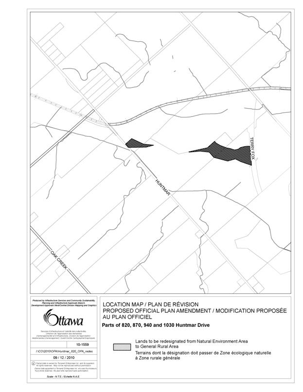
BACKGROUND
The subject lands, 820, 870, 940, 1030 Huntmar
Drive, are located north of Richardson Side Road, between Huntmar Drive and the
extension of Terry Fox Drive.
Specifically, the affected lands are located along the boundary between
the Natural Environment Area (the South March Highlands) and General Rural Area
designations, in the vicinity of the northern property lines of 820, 870, 940
Huntmar Drive and the southern property line of 1030 Huntmar Drive as shown on
Document 4.
These lands are located in the rural west area
of the city, straddling the southern boundary of the South March Highlands, an
area of ecological significance approximately 894 hectares in size. The subject lands are composed of pasture
lands and forested areas. Adjacent lands
to the west and south are in agricultural use.
The Carp River runs diagonally through 820, 870, 940 and 1030 Huntmar
Drive. Lands to the east of the Terry
Fox Drive extension are within the urban area. There is a detached dwelling located at 1030
Huntmar Drive.
On June 25, 2008 City Council adopted the new
Zoning By-law 2008-250, affecting all properties within Ottawa. An appeal was received from Richcraft Homes Limited
regarding 13 hectares of land located at 820, 870 and 940 Huntmar
Drive.
Initially, the position of the appellant was that the location of the boundary between the RU (Rural Countryside Zone) and the EP3 (Environmental Protection Subzone 3) was in error. Following discussions with the appellant it was agreed that the zoning boundary was not in error, as it corresponds correctly with the boundary of the Natural Environment Area, as shown in Schedule A of the Official Plan.
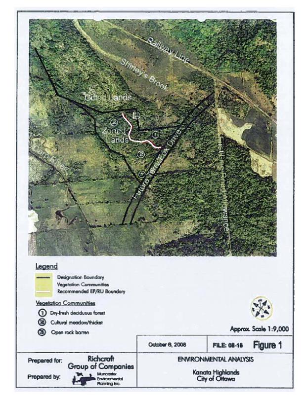
The appellants revised the reasons for their appeal, stating that the boundary between the two zones should be amended to reflect the findings of a report by Muncaster Environmental Planning dated October 6, 2008 and received by the City on January 13, 2010, included as Document 1- Information from Muncaster Environmental Planning (staff note that the proposed boundary on the map shown on the last page of Document 1 has been highlighted in white by staff so it will be legible when reproduced in black and white).
This appeal was considered at an Ontario Municipal Board hearing on May 13, 2010. At that hearing, the City brought forward a motion to request an adjournment to permit the information from Muncaster Environmental Planning to be brought before Council for consideration. A decision was issued by the Ontario Municipal Board allowing the adjournment. Direction was given by the Board to bring the Muncaster report forward to Council for its consideration and for a written recommendation from Council to be brought forward to the Ontario Municipal Board.
In response to the Board’s decision, the information in the Muncaster report and a revised zoning boundary between the RU (Rural Countryside Zone) and the EP3 (Environmental Protection Subzone 3) was proposed in a report to the Agricultural and Rural Affairs Committee on August 26, 2010. However, in the opinion of staff, the change to the zoning boundary was significant enough to warrant an Official Plan amendment. Further to this, the Agriculture and Rural Affairs Committee recommended that Council direct staff not to forward the Zoning By-law amendment to Council until such time as an Official Plan amendment has been processed and the Official Plan amendment by-law rises to Council.
Purpose of Amendments
The objective of the amendments is to more
accurately locate the Official Plan and zoning boundaries along the southern
edge of the South March Highlands and to facilitate the resolution of an
appeal of the Zoning By-law. There is no
development proposed or associated with the amendments. The proposed amendment would result in approximately 7.1 hectares of
land being re-designated from Natural Environment Area to General Rural Area, with
the same lands also being rezoned from EP3 (Environmental Protection Subzone 3)
to RU [xxxr] –h (Rural Countryside Zone, Exception [xxxr], Holding Zone). The provisions in exception [xxxr] would
prohibit development until an environmental impact statement demonstrates that
the site does not provide significant habitat for endangered and threatened
species.
The location of the existing boundary of the
Natural Environment Area was based on air photo and topographical mapping
information. The location of the proposed boundary is based on information
gathered through a detailed examination of the lands over the course of several
site visits in the spring, summer and early fall of 2010. The entire length of the Natural Environment
Area boundary between Huntmar Drive and the Terry Fox extension was
examined. For this reason, changes are
proposed along the length of the boundary, including the lands at 1030 Huntmar
Drive which were not involved in the appeal of the Zoning By-law, but more accurately
reflect the southern edge of the Natural Environment Area.
DISCUSSION
Section 2 of the Planning Act requires municipalities to have regard for matters of provincial interest when carrying out their responsibilities under the Act. Matters of provincial interest that are relevant to these amendments are the protection of ecological systems, including natural areas, features and functions.
Section 3(5) of the Planning Act requires that the decision of a municipal Council shall be consistent with the policies in the Provincial Policy Statement (PPS), a document that provides further detail regarding matters of provincial interest.
Section 2.1 of the PPS includes policies that require the protection of natural heritage features and areas for the long term. The policies do not permit development or site alteration in significant habitat of endangered species and threatened species or in significant wetlands. Development and site alteration are not permitted in significant woodlands, wildlife habitat or areas of natural and scientific interest, unless it has been demonstrated that there will be no negative impacts on the natural features or their ecological functions.
Further, development and site alteration are not permitted on adjacent lands to natural heritage features unless the ecological function of the adjacent lands has been evaluated and it has been demonstrated that there will be no negative impacts on the natural features or on their ecological functions. Nothing in these policies is intended to limit the ability of existing agricultural uses to continue.
The PPS defines an area of natural and scientific interest (ANSI), as an area identified as provincially significant by the Ontario Ministry of Natural Resources using evaluation procedures established by the Province. The subject lands are within the South March Highlands Candidate ANSI. The Candidate ANSI was first identified as a significant area on the basis of three criteria: regionally significant landform, consisting of the Hazeldean Escarpment and Precambrian bedrock; a low level of disturbance from past human land uses; a high diversity of native vegetation communities and species, especially along the slope and summit of the Hazeldean Escarpment. Site investigations revealed that the sections of the property affected by the proposed amendments do not meet all of the criteria for which the Candidate ANSI was identified, given the degree of disturbance in the subject lands and the displacement of native vegetation communities with non-native species.
While there is no development contemplated in association with the proposed boundary amendment, an environmental impact statement is required as the boundary adjustment is considered a land use change. In keeping with policies in the PPS and criteria in Section 4.7.8 of the Official Plan, a scoped environmental impact statement was completed by City staff. The statement concluded that the proposed amendment to the boundary would not impact the Natural Environment Area negatively.
Findings of the Environmental Impact Statement indicate that there is a high potential for significant habitat for endangered or threatened species within the subject lands. In the PPS, the term “significant habitat of endangered and threatened species” is defined as,
the habitat, as approved by the Ontario Ministry of Natural Resources, that is necessary for the maintenance, survival, and/or the recovery of naturally occurring or reintroduced populations of endangered species or threatened species, and where those areas of occurrence are occupied or habitually occupied by the species during all or any part(s) of its life cycle.
Accordingly, in order for habitat to qualify as significant habitat for endangered and threatened species, approval of the Ministry of Natural Resources is required. This approval has not been provided by the Ministry with regard to the subject lands.
Official Plan
The subject lands are designated Natural Environment Area as shown on Schedule A of the Official Plan and shown in Document 2. The policies for this designation apply to land having a high environmental value as assessed through federal, provincial, and municipal studies. Extensive portions of Natural Environment Areas are owned privately and their protection depends on private stewardship.
Given the ecological value of lands within Natural Environment Areas, only uses that do not adversely affect the natural characteristics of the area, such as open air recreation, scientific, educational, or conservation uses associated with the features of the environmental area, existing agriculture operations, or forestry as defined by the Forestry Act, are permitted. A single-detached dwelling is permitted on existing lots, where the lot fronts on an existing public road and where a dwelling is permitted in the Zoning By-law. Further policies state that development and site alteration will not be permitted within the feature or within 120 metres of the feature unless an environmental impact statement can demonstrate that there will be no negative impacts on the natural features within the area or on their ecological functions.
Policy 3.2.2.9 deals with boundaries of Natural Environment Areas, stating that the boundaries are based on a variety of mapping sources. When more up-to-date information becomes available through such means as detailed environmental studies, an adjustment to the interpretation of the boundary may be warranted. The policy states that the City’s Zoning By-law will reflect the most up-to-date and accurate information and therefore any changes, whether minor or major will require an amendment to the Zoning By-law. However, minor changes to the boundaries will not require an amendment to the Official Plan. Where boundary interpretation impacts provincially significant Areas of Natural and Scientific Interest, the agreement of the Ministry of Natural Resources is required. Given this area is a Candidate ANSI, staff has notified and consulted the Ministry regarding the proposed amendments to the Official Plan and zoning boundaries. The Ministry has advised City staff that they are reviewing the status and boundaries of all Candidate ANSI in Ottawa and cannot comment on the boundaries of the South March Highlands Candidate ANSI at this time.
Given the degree of disturbance in the subject lands and the displacement of native vegetation communities with non-native species, staff recommend that the subject lands not be included within the boundary of the Natural Environment Area. The General Rural Area designation is considered the appropriate land use designation for the re-designated lands, given the physical characteristics of these lands, which are composed of forest and pasture (see Document 2 for details on the proposed Official Plan Amendment). Uses permitted in the General Rural designation include agricultural uses, forestry and conservation uses, natural resource management activities, animal boarding, breeding, and training facilities, including stables, bed and breakfast establishments, open space, cemeteries and residential uses. It is noted that policies for the General Rural designation require an environmental impact statement for development that could impact an adjacent natural heritage feature, such as the South March Highlands. In addition, development and site alteration is not permitted within 120 metres of the boundary of a natural heritage feature unless an environmental impact statement demonstrates that there will be no negative impacts on the natural features or its ecological functions.
Country lot subdivisions within the General Rural Area designation may not impede the ability of Villages and urban areas to expand over the planning period, and may not be located within one kilometre of an approved urban and Village boundary. As such, a county lot subdivision is not permitted on the subject lands, which are abutting the urban boundary. Further, there is currently a moratorium on the development of new country lot subdivisions. This moratorium is in place until the earlier of five years from the date of adoption of the Official Plan, or the coming into force of an Official Plan amendment that removes this moratorium and reinstates the existing policies or replaces them with new policies.
Zoning By-law
The current zoning of the subject lands is EP3 (Environmental Protection Subzone 3). The purpose of the Environmental Protection zone is to recognize lands which are designated in the Official Plan as Significant Wetlands, Natural Environment Areas and Urban Natural Features that contain important environmental resources which must be protected for ecological, educational and recreational reasons. Environmental Protection zones permit only those uses which are compatible with and assist in the protection of the environmental attributes of these lands, or are in keeping with applicable Official Plan policies. As it is recommended that the subject lands should be re-designated to General Rural Area, the existing EP3 zone is no longer appropriate. As detailed in Document 3, the RU (Rural Countryside Zone) is recommended, as the purpose of this zone is to accommodate agricultural, forestry, residential lots created by severance and other land uses characteristic of Ottawa’s countryside in areas designated as General Rural Area.
Given that the Environmental Impact Statement
has identified a high potential for significant habitat for endangered and
threatened species on the subject lands, it is proposed that the subject lands be
rezoned from EP3 (Environmental Protection Subzone 3) to an RU [xxxr]-h (Rural
Countryside Zone, Exception [xxxr], Holding Zone). The holding symbol would state that development,
including construction of buildings or structures, is prohibited until an environmental impact statement
demonstrates that the site does not provide significant habitat for endangered
and threatened species.
Summary
According to Official Plan policies, the boundaries
of Natural Environment Areas and associated zoning boundaries should be based
on the most up-to-date information. Re-designation
to General Rural Area is considered appropriate given the results of the
site-specific evaluation of the boundary, which included observations regarding
the displacement of native vegetation species with non-native species and the degree
of disturbance in the subject lands. The
Rural Countryside Zone with holding symbol provision will address concerns
regarding the high potential for significant habitat for endangered or
threatened species being located within the subject lands. This limitation on development will ensure
that the proposed Official Plan and zoning designations are consistent with
policies contained in the PPS and Official Plan.
ENVIRONMENTAL IMPLICATIONS
An Environmental Impact Assessment (EIS) was prepared by City staff. The EIS was peer reviewed by the Mississippi Valley Conservation Authority (MVC). The EIS concluded that there will be no negative impacts on the natural features or on their ecological functions as a result of the proposed amendments. The EIS provides recommended mitigation measures and constraints for consideration for development requiring approvals under the Planning Act. The proposed zoning addresses concerns regarding significant habitat for endangered or threatened species. Comments from MVC and the Environmental Advisory Committee regarding the EIS are addressed in the Consultation Details (Document 5). Where appropriate, the EIS has been revised.
The Environmental Advisory Committee was given the opportunity to review and provide comments regarding the EIS. Staff attended the December 9, 2010 meeting of the Environmental Advisory Committee to discuss the proposed amendments.
RURAL IMPLICATIONS
Development of the subject lands
would not be permitted until the holding symbol is removed. Removal of the holding symbol would not be
possible without confirmation from the Ministry of Natural Resources that the
lands do not provide significant habitat for endangered or threatened species. In the event the Ministry confirms there is
no significant habitat and the holding symbol is removed, the proposed Official
Plan and zoning designations would permit a limited range of uses including a
veterinary hospital, a kennel, an artist’s studio and buildings and outdoor
areas for the stabling and training of horses.
CONSULTATION
Notice for the Official Plan and Zoning By-law amendments was carried out in accordance with the City's Public Notification and Consultation Policy.
The Ministry of Natural Resources and the Mississippi Conservation Authority have been notified of the proposed amendments.
Staff arranged a visit of the subject lands with members of the public, the Environmental Advisory Committee and the March Rural Community Association on November 10, 2011.
Comments were received from the public. Detailed responses to the notification/circulation are provided in Document 5.
COMMENTS BY THE WARD COUNCILLOR(S)
The Ward Councillors are aware of these amendments and the staff recommendations.
LEGAL/RISK MANAGEMENT
IMPLICATIONS:
The adoption of the recommendations in this report will permit the resolution of an appeal to the Ontario Municipal Board. In the event that the recommendations are not adopted, a two- to three-day hearing will be required and outside witnesses will need to be retained. The estimated cost would be $30,000 to $40,000.
CITY STRATEGIC PLAN
The staff recommendations support policies in Section 2.4.2 regarding Natural Features and Functions. These policies direct that significant habitat of endangered or threatened species should be protected.
TECHNICAL IMPLICATIONS
N/A
FINANCIAL IMPLICATIONS
There are no direct financial implications associated with this report.
SUPPORTING DOCUMENTATION
Document 1 Information from Muncaster Environmental Planning
Document 2 Proposed Official Plan Amendment
Document 3 Details of Recommended Zoning
Document 4 Zoning/Location
Map
Document 5 Consultation
Details
DISPOSITION
Planning and Growth Management to prepare the by-law for Recommendation 1 to adopt the Official Plan
Amendment, forward to Legal Services, and undertake the statutory
notification.
Legal Services to forward the by-law regarding Recommendation 1 to implement the Official Plan amendment to City Council.
Planning and Growth Management to prepare the implementing by-law for Recommendation 2, forward to Legal Services.
Legal Services to forward the by-law regarding Recommendation 2 to implement the Zoning By‑law amendment to City Council.
INFORMATION FROM MUNCASTER ENVIRONMENTAL
PLANNING DOCUMENT
1
PROPOSED OFFICIAL PLAN AMENDMENT DOCUMENT
2
Land use
Utilisation du sol

The Statement of Components
PART A – THE PREAMBLE
Purpose
Location
Basis
PART B – THE AMENDMENT
Introductory Statement
Details of the Amendment
THE STATEMENT OF
COMPONENTS
PART A – THE PREAMBLE, introduces the actual Amendment but does not constitute part of Amendment No. X to the City of Ottawa Official Plan.
PART B – THE AMENDMENT, consisting of the following text and maps constitutes both the actual Amendment No. X to the City of Ottawa Official Plan.
PART A - THE PREAMBLE
1.0 Purpose
The purpose of Amendment No. X to the City of Ottawa
Official Plan is to amend the boundary between the Natural Environment Area and
the General Rural Area designations, as shown in Schedule A of the Official
Plan. The amendment will more accurately locate the southern
boundary of the Natural Environment Area designation applied to the South March
Highlands.
2.0 Location
The subject lands, 820, 870, 940, 1030 Huntmar
Drive, are located north of Richardson Side Road, between Huntmar Drive and the
extension of Terry Fox Drive.
Specifically, the affected lands are located along the boundary between
the Natural Environment Area (the South March Highlands) and General Rural Area
designations, in the vicinity of the northern property lines of 820, 870, 940
Huntmar Drive and the southern property line of 1030 Huntmar Drive.
2.0 Basis
3.1 Background
Section 2 of the Planning Act requires municipalities to have regard for matters of provincial interest when carrying out their responsibilities under the Act. Matters of provincial interest that are relevant to these amendments are the protection of ecological systems, including natural areas, features and functions.
Section 3(5) of the Planning Act requires that the decision of a municipal council shall be consistent with the policies in the Provincial Policy Statement (PPS), a document that provides further detail regarding matters of provincial interest. Section 2.1 of the PPS includes policies that require the protection of natural heritage features and areas for the long term. The policies require that the diversity and connectivity of natural features and the long-term ecological function and biodiversity of natural heritage systems should be maintained, restored or, where possible, improved. The policies do not permit development or site alteration in significant habitat of endangered species and threatened species or in significant wetlands. Development and site alteration are not permitted in significant woodlands, wildlife habitat or areas of natural and scientific interest, unless it has been demonstrated that there will be no negative impacts on the natural features or their ecological functions. Further, development and site alteration are not permitted on adjacent lands to natural heritage features and areas unless the ecological function of the adjacent lands has been evaluated and it has been demonstrated that there will be no negative impacts on the natural features or on their ecological functions. Nothing in these policies is intended to limit the ability of existing agricultural uses to continue.
The PPS defines an area of natural and scientific interest (ANSI), as an area identified as provincially significant by the Ontario Ministry of Natural Resources using evaluation procedures established by the Province. The subject lands are within the South March Highlands Candidate ANSI.
The Candidate ANSI was first identified as a significant area on the basis of three criteria: regionally significant landform, consisting of the Hazeldean Escarpment and Precambrian bedrock; a low level of disturbance from past human land uses; a high diversity of native vegetation communities and species, especially along the slope and summit of the Hazeldean Escarpment. Site investigations reveal that the sections of the property affected by the proposed amendments do not meet all of the criteria for which the Candidate ANSI was identified, given the degree of disturbance in the subject lands and the displacement of native vegetation communities and species with non-native species.
Findings of the Environmental Impact Statement indicate that there is a high potential for habitat for endangered or threatened species within the subject lands. In the PPS, the term “significant habitat of endangered and threatened species” is defined as,
the habitat, as approved by the Ontario Ministry of Natural Resources, that is necessary for the maintenance, survival, and/or the recovery of naturally occurring or reintroduced populations of endangered species or threatened species, and where those areas of occurrence are occupied or habitually occupied by the species during all or any part(s) of its life cycle.
Accordingly, in order for habitat to qualify as significant habitat for endangered and threatened species, approval of the Ministry of Natural Resources is required. This approval has not been provided by the Ministry with regard to the subject lands.
The subject lands are designated Natural Environment Area as shown on Schedule A of the Official Plan. The policies for this designation apply to land having a high environmental value as assessed through federal, provincial, and municipal studies. Extensive portions of Natural Environment Areas are owned privately and their protection depends on private stewardship.
Given the ecological value of lands within Natural Environment Areas, only uses that do not adversely affect the natural characteristics of the area, such as open air recreation, scientific, educational, or conservation uses associated with the features of the environmental area, existing agriculture operations, or forestry as defined by the Forestry Act, are permitted. A single-detached dwelling is permitted on existing lots, where the lot fronts on an existing public road and where a dwelling is permitted in the Zoning By-law. Further policies state that development, such as a Zoning By-law amendment, and site alteration will not be permitted within the feature or within 120 metres of the feature unless an environmental impact statement can demonstrate that there will be no negative impacts on the natural features within the area or on their ecological functions. The requirements of the environmental impact statement may vary, and are described in Section 4.7.8 of the Official Plan. While there is no development contemplated in association with the proposed boundary amendment, an environmental impact statement is required as the boundary adjustment is considered a land use change. In keeping with criteria in Section 4.7.8, a scoped environmental impact statement was completed by City staff. The statement concluded that the proposed amendment to the boundary would not impact the Natural Environment Area negatively.
Policy 3.2.2.9 deals with boundaries of Natural Environment Areas, stating that the boundaries are based on a variety of mapping sources. When more up-to-date information becomes available through such means as detailed environmental studies, an adjustment to the interpretation of the boundary may be warranted. The policy states that the City’s Zoning By-law will reflect the most up-to-date and accurate information and therefore any changes, whether minor or major, will require an amendment to the Zoning By-law. However, minor changes to the boundaries will not require an amendment to the Official Plan. Where boundary interpretation impacts provincially significant Areas of Natural and Scientific Interest, the agreement of the Ministry is required. The Ministry has been notified and consulted regarding the proposed amendments to the Official Plan and zoning boundaries.
Given the degree of disturbance in the subject lands and the displacement of native vegetation communities and species with non-native species, it is recommended that the subject lands should not be included within the boundary of the Natural Environment Area. The General Rural Area designation is considered the appropriate land use designation for the re-designated lands, given the physical characteristics of these lands, which are composed of forest and pasture. Uses permitted in the General Rural designation include agricultural uses, forestry and conservation uses, natural resource management activities, animal boarding, breeding, and training facilities, including stables, bed and breakfast establishments, open space, cemeteries and residential uses. A Zoning By-law amendment is required to establish a new industrial, institutional or commercial use, or a country lot subdivision. It is noted that policies for the General Rural designation require an environmental impact statement for development that could impact an adjacent natural heritage feature, such as the South March Highlands. In addition, development and site alteration is not permitted within 120 metres of the boundary of a natural heritage feature unless an environmental impact statement demonstrates that there will be no negative impacts on the natural features or its ecological functions.
Country lot subdivisions within the General Rural Area designation may not impede the ability of Villages and urban areas to expand over the planning period, and may not be located within 1 kilometre of an approved urban and Village boundary. As such, a county lot subdivision is not permitted on the subject lands, which are abutting the urban boundary. Further, there is currently a moratorium on the development of new country lot subdivisions. This moratorium is in place until the earlier of five years from the date of adoption of the Official Plan or the coming into force of an official plan amendment that removes this moratorium and reinstates the existing policies or replaces them with new policies.
Given that the Environmental Impact Statement
has identified a high potential for significant habitat for endangered and
threatened species on the subject lands, zoning provisions will prohibit
development, including construction of buildings or structures, until an environmental impact statement
demonstrates that the site does not provide significant habitat for endangered
and threatened species. This limitation on development will
ensure that the proposed Official Plan designations are consistent with
policies contained in the PPS and Official Plan.
PART B – THE AMENDMENT
1.0 The Introductory Statement
All of this part of this document entitled Part B – The Amendment, consisting of the following text, constitutes Amendment No. X to the City of Ottawa Official Plan.
2.0 Details
of the Amendment
2.1 The City of Ottawa Official Plan, Volume 1, is hereby amended as follows:
3.0 Interpretation
Implementation
and interpretation of this Amendment shall be made having regard to policies
from all of the chapters of the Official Plan.
SCHEDULE A
DETAILS OF RECOMMENDED
ZONING DOCUMENT
3
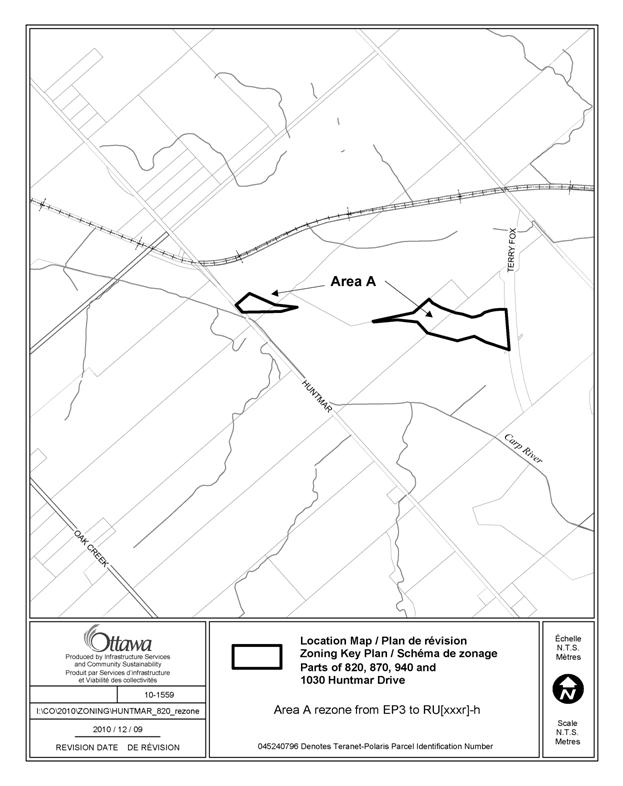
Proposed changes to the Comprehensive Zoning By-law for part of the lands located at 820, 870, 940, 1030 Huntmar Drive, as shown in Documents 4:
1. The subject lands shown as Area A in Document 4 are rezoned from EP3 to RU [xxxr] -h.
2. Provisions of [xxxr] to read as follows:
-despite the provisions of the underlying zone, all uses and development, including the construction of buildings and structures, are prohibited until the holding symbol is removed.
-the holding symbol can be removed only after an Environmental Impact Statement has been submitted and demonstrates, to the satisfaction of the General Manager of Planning and Growth Management and the Ministry of Natural Resources, that the site does not provide significant habitat for endangered species or threatened species.
ZONING /LOCATION
MAP Document 4
CONSULTATION DETAILS DOCUMENT
5
PUBLIC COMMENTS
Notification and public consultation were undertaken in accordance with the Public Notification and Public Consultation Policy approved by City Council for Official Plan and Zoning By-law amendments. There were extensive comments received from the public.
SUMMARY OF PUBLIC INPUT
Comment: This is a diverse and complex ecosystem. This area supports more than 680 natural species of life including 18 species at risk and of which two are on the endangered species list. This area has 30 eco-types of plants and ten different wildlife habitats! For the complexity of this area rezoning should not be permitted. We are 100% opposed to this amendment. Leave the environment areas alone!
Response: As discussed in the report, the existing boundaries were determined using air photo and topographical information. The proposed boundary adjustments are based on information gathered through site visits undertaken over the course of the spring, summer and early fall 2010. It is recommended that the subject lands not be included within the boundary of the Natural Environment Area given the degree of disturbance in the subject lands and the displacement of native vegetation communities with non-native species that was observed.
Comment: One of the main criteria being applied for determining the boundary is the geological foundation for the environmentally protected land. On that basis it is difficult to agree that the rezoning should extend into the ridge area.
According to my GPS, the rock knoll that we ended up at had an elevation of 122 M. This is consistent with the elevations found across the western portion of the ridge which range from 125 – 129 in the high spots. In fact the decline in the saddle area between that western section to where we were is only to 115 m (less than 6%). This dip occurs for only about 100 m.
By comparison, the decline on the opposite side east to the other saddle where TFDE is located is down to 108 M – an 11.5% drop that is roughly twice as much. The dip on the east side where the road is to where the elevation is regained is approx. 300m.
Thus based on elevation alone, there appears to be a good case for asserting that the ridge is essentially continuous and (as a result of the blasting for the road) now ends where TFDE cuts through it. On that basis, the ridge area should be excluded from the rezoning.
Response: There are three criteria that were considered in the identification of the South March Highlands Candidate ANSI: regionally significant landform, consisting of the Hazeldean Escarpment and Precambrian bedrock; a low level of disturbance from past human land uses; a high diversity of native vegetation communities and species, especially along the slope and summit of the Hazeldean Escarpment.
In determining the proposed boundary,
consideration was given to all of the criteria.
There is a distinct
break in the ridge that has permitted cattle to access areas behind the
knoll.
As a result of this access, the plant
communities on the top of the knoll and the valley behind it have been affected
to the extent that non-native species are dominant. The rock knoll is isolated from the main
ridge line and the plant species dominating its top do not represent natural,
rock barren vegetation. Given the level
of disturbance, the plant species present and the isolation of the knoll from
the main ridge line, the knoll does not meet the majority of criteria for which
the Candidate ANSI was identified.
Comment: The other main criteria being applied for determining the boundary is the type of vegetation found. However, since the vegetation studied is only for vascular plants, and due to the significant quantity of moss and lichen in the ridge area that is to be rezoned, the analysis to incomplete unless it is extended to include non-vascular vegetation.
At an elevation of 122 m, the approximate age of the area is 10,000 years and thus has a high probability of reflecting/retaining some of the sub-arctic vegetation that was present in the area at that time. Rare and provincially unique ferns and mosses have been found further up the Ottawa valley for the same reason (the Baron River and Dumoine River Canyon walls come to mind immediately). Rare grasses (which are vascular) have also been found at high elevation throughout the SMH for the same reason.
Although it is apparent that invasive species appear to have dominated in the lower pasture areas, that dominance diminished as we proceeded up to the ridge. I noticed native wild strawberry and mint as we climbed, indicating that the soil and microclimate change on the ridge area provides greater defence against invasive species than the pasture areas below.
Shouldn’t a study of bryophytes, mosses and lichens be conducted to provide thorough analysis before relying principally on vegetation? Although it is true that vascular plants play a significant role in the food chain for most wildlife, non-vascular species are also important as habitat and food sources for insects and other arthropods upon which wildlife depend. In the past, the City has over-emphasized studies of vascular plants in the SMH and not paid any attention to the ecological importance of bryophytes.
Response: Staff determined that a scoped environmental impact statement was appropriate, according to requirements in Section 4.7.8 of the Official Plan regarding environmental impact statements. In that environmental impact statement, staff examined the integrity of the plant community as a whole. An examination of non-vascular plants was not considered necessary given the scope of the study.
Comment: On the subject of vegetation, the stand of old-growth burr oak that we saw was impressive. The tree that I measured had a circumference of 261.6 cm and thus a diameter of 83 cm. The 230 year old black maple that we documented after it was cut-down for TFDE (approx. 1km away) had a diameter of 109 cm. Assuming the growth rate for the oak and maple are roughly similar, this would put the age of that oak at no more than 175 years old.
If we consider the possibility that the great fire of 1870 razed the area and that burr oak may grow faster than black maple, the minimum age of the oak would be 130 years. Hence we might conclude that that tree and its neighbours are roughly 150 years old.
On that basis, I would suggest that establishing a separate zone that includes that stand of old growth trees (even if it is just an island in the zoning) would be entirely defensible.
Since the Distinctive Tree by-law does not apply to land outside of the urban boundary, the City should use EP or O1 zoning to protect significant stands since the genetic quality of any tree of that great age is worth protecting. According to the MNR, old-growth recognition should occur when forest stands are over 120 years old.
A related issue is the ridiculous fact that an EP zoning designation allows for tree clearing. Presumably this is on the basis that a large forest can with stand some degree of well-managed forestry – if so this clearly should be limited to EP areas over 100 hectares in size. I’ve copied Heather Hamilton, vice-chair of the Ottawa Forest and Greenspace Advisory Committee so that she can raise this as an issue for OFGAC to pursue. In the meantime, providing the highest zoning protection possible is entirely appropriate. Perhaps it should be considered whether O1 provides better protection than EP for this stand of trees.
Response: Section 34
of the Planning Act gives
municipalities the ability to regulate land use through zoning. However, zoning by-laws do not have
jurisdiction to regulate tree-cutting activities by property owners. In the absence of a municipal by-law to
control tree-cutting in rural areas, a property owner may remove a tree at
their discretion. If the tree-cutting
activity is for the development, management and cultivation of timber resources
grown on-site, this type of activity is defined and regulated in the Zoning
By-law as a forestry operation land
use. It is permitted in certain zones,
including the EP3 Zone. While deleting a forestry
operation from the list of permitted uses in environmental zones would no
longer permit the management of timber resources in these zones, tree-cutting
by property owners would still be permitted as there is no municipal by-law in
force that can prevent this activity in rural areas.
Comment: While on the ridge, I noticed bear scat. This supports the case for the “missing criteria” of significant wildlife habitat. It is a well-recognized ecological fact that wildlife corridors exist along ridges and escarpments. In the SMH, bear, coyote, and wolf will certainly roam the ridge. The owner of 1030 Huntmar Drive has also identified Bobcat as previously seen in the vicinity – also highly likely to be a user of the ridge top.
We already discussed the fact that deer and turtles are likely to use the saddle and ridge base as a different corridor so I won’t elaborate on that further. Aside from the corridor function, we also discussed the fact that the area provides habitat for bird species at risk (bobolink, whip-poor-will, and possibly loggerhead shrike to the extent that they may still exist in the SMH). So I won’t dwell on that further other than to point out that the southern exposure provided by the ridge may be attractive nesting area for Blanding’s – who are known to prefer warm southern exposures of sandy soil when nesting (since the temperature of the soil determines the sex of the turtle in the egg). We did not have an opportunity to examine the soil on those slopes leading down from the ridge.
I’ve attached my copy of the MNR Significant Wildlife Habitat Technical Guide. During our conversation yesterday, it was identified that the MNR is usually involved in the designation of significant wildlife habitat. However (in the attached page 1) according to the MNR’s interpretation of the Provincial Policy Statement (PPS), they are not the only authority who may do so: “Criteria for determining significance may be recommended by the Province, but municipal approaches that achieve the same objective may also be used.”
One may reasonably conclude that the City is on firm ground in recognizing the significant wildlife habitat function in this area of the SMH as it considers the zoning of the area. Also since we all know that general habitat protection will arrive for the area in 2013, it would be difficult for the OMB to object to the City adopting a 3-year planning horizon on this zoning question.
It is also evident from reading the attached, that the ANSI is only one of several useful criteria to consider when designating significant wildlife habitat for the purposes of land designations under the PPS. Corridor function gets a whole chapter in the handbook. Chapter 7 also speaks to the increased importance of preserving wildlife corridors in the vicinity of major roads (such as TFDE) so that wildlife may be encouraged to use the corridor instead of being killed on the road.
Response: The
potential for significant habitat for endangered or threatened species has been
considered. The proposed zoning will not
permit development until it has been confirmed there is no significant habitat
for endangered or threatened species.
Staff note that the PPS defines significant habitat for endangered or
threatened species as habitat that has been approved by the Ministry of Natural
Resources. While municipalities may be
involved in assisting with criteria for determining significant habitat,
approval of that habitat is the jurisdiction of the Ministry of Natural
Resources.
Comment: The owner of 1030 Huntmar Drive re-iterated his opposition to re-zoning of his land from EP to RU. If this area is not to be designated as EP, the City should strongly consider O1 as a more appropriate zoning designation than RU. The definition of O1 includes “River Corridors as identified in the Official Plan” and the Carp River corridor certainly qualities.
Since the land in question can have no agricultural value (currently forested and deeply within the flood plain), it is difficult to understand a rationale for using RU instead of O1.
In view of the above, the City should reconsider the proposed boundary changes to ensure that (1) the ridge, western saddle, and base of the ridge remains EP protected; (2) the stand of old growth oak is provided its own designated protection TBD; and (3) the area adjacent to the Carp River is zoned as open space.
Response: The property
owner supports a Parks and Open Space Zone because of the limited range of uses
permitted in that zone, which are as follows: community garden, environmental
preserve and education area, park. While
it is understood that the owner’s objective is to limit the potential for
development on the area of lands to be rezoned, the presence of the floodplain
overlay on these lands has already addressed this issue. No development is permitted.
The purpose statement for the O1 - Parks and
Open Space Zone indicates the zone is to be used to permit, “parks, open space
and related and compatible uses…” Lands
within this zone are normally used for public purposes for access to open space
in parks. The O1 zone has not been used
on lots used for residential purposes in the General Rural Area designation,
given the large lot sizes and the low intensity of development permitted in the
Environmental Protection, Rural Countryside and Agricultural Zones. The area of the lot where development is
permitted is small and the remaining area is necessarily open space. While the
selection of an O1 zone is a preference of the property owner, the land use
rationale for selecting this zone in this context is not supportable. Similar lands along the Carp River are within
RU - Rural Countryside or AG - Agricultural Zones. The proposed zoning is consistent with the
approach taken in the Comprehensive Zoning By-law with regard to similar lands
on river corridors in the General Rural Area designation.
Comment: My comments are specific to the issue of the area of floodplain hazard / flood plain elevation that should apply to the OPA (and subsequent Planning Act approvals). According to the latest study completed by the "Modelkeeper", the floodplain elevation of the Carp River at the subject properties is 93.46m (see attached Table 4.1 from the May 2010 report by Greenland). The flood level has increased 0.36m since the original floodplain mapping that was prepared in 1983 that the MVCA continues to use in its regulation, despite the decades of development in the watershed and encroachments into the floodplain approved by the MVCA that have occurred since the 1983 floodplain mapping was prepared. According to Section 4.8.1.1 of the Official Plan: "The policies for flood plains apply to those areas designated on Schedule K as well as areas where flood plains exist but are not mapped by Conservation Authorities and are not designated." Notwithstanding the outdated floodplain mapping that is (irresponsibly) being used by the MVCA for regulation under Section 28 of the Conservation Authorities Act, the City has a different standard - which includes the area subject to flooding to elevation 93.46m - not just the Regulatory Floodplain used by the MVCA. I have an outstanding Appeal to the OMB of the Draft Approval of the Richcraft Plan of Subdivision in Kanata West that includes an extensive floodplain area. In my opinion such development is inconsistent with the Natural Hazard Policies of the PPS, given that One Zone floodplain policy applies. The impact of the floodplain development in Kanata West is factored into the revised floodplain elevations on the property owned by Richcraft on Huntmar Drive. I submit Richcraft can't have it both ways. They can't be the beneficiaries of floodplain development in Kanata West, and have the old floodplain mapping apply to their benefit on the Huntmar Drive property.
Response: There is no development associated with the proposed amendments and residential subdivisions will not be permitted as a result of the proposed amendments. In addition, the proposed amendments will not permit development of the subject lands, which are 292 metres from the edge of the flood plain, until the holding symbol has been lifted. If the holding symbol is lifted, the level of intensity of development that would be permitted would be comparable to one detached dwelling, a use that is already permitted.
Comment: The report in the Ottawa Citizen (Friday, September 24: C3) provides a very clear explanation of issues surrounding the ARAC decision to approve the rezoning of approximately 5½ ha of land on the Ottawa side of the Carp River. Councillor Glenn Brooks is quite correct in observing that it is difficult to rezone environmental protection land into development land.
It is much easier to have it rezoned to rural in anticipation of the expansion of the urban boundary. Then the included rural lands that are owned by developers become properties ready for the subdivision development, according to urban regulations.
Valid concerns about the frequent flooding of the Carp River into the existing communities in Kanata and downstream to the village of Carp and surrounding farmlands, and the requirements for wildlife corridors in this environmentally sensitive area were discounted by ARAC.
The immediate effects of rezoning have less to do with a comparatively small change in the boundaries of land adjacent to the Carp River and more to do with providing the developer with a clearly defined area for building a subdivision without a piece of environmental protection land cutting the property in two. This developer, along with others, will go to the OMB in February to apply for an expansion of the urban boundary, which will include this property.
According to the City, the annual cost of providing services to residences outside the Greenbelt is more than the taxes assessed per residence. This means that, after the developers have built and sold the homes in their new suburbs outside the Greenbelt, City tax payers must pay in excess of $1000 per house every year to maintain the essential services of water, sewer, police, and the parks and community centres that help to make these housing developments liveable.
Expanding the urban boundaries under the present tax system is fiscally irresponsible. Taxpayers cannot afford suburban development outside the Greenbelt. ARAC made the wrong decision.
Response: Staff note that ARAC did not approve the Zoning By-law amendment. There is a commitment in Section 3.2.2.9 of the Official Plan to base the location of Official Plan and zoning designations on the most up-to-date information available. The accuracy of the boundary must be addressed, and this issue is separate from the development potential of the property. The range of uses permitted in the RU Zone are low-intensity, and generally comparable in impact to a detached dwelling with accessory building. These uses would only be permitted at the time the holding symbol is removed. Regarding impacts of any rezoning on the floodplain, the proposed amendments will not permit development of the subject lands, which are 292 metres from the edge of the flood plain, until the holding symbol has been lifted. If the holding symbol is lifted, the level of intensity of development that would be permitted would be comparable to a detached dwelling, a use that is already permitted. A General Rural designation is considered the appropriate designation, given the characteristics of the land. As such, the Rural Countryside Zone is considered appropriate, as this is the zone that implements the policies for the General Rural Area. The proposed amendments are intended to bring a comprehensive and consistent approach to the evaluation of the southern edge of the location of this Natural Environment Area boundary.
COMMUNITY ORGANIZATION COMMENTS
Comment: The March Rural Community Association (MRCA) opposes the rezoning portions of lands known as 820, 870, 940 and 1030 Huntmar Road from EU3 (Natural Environment Area) to RU (General Rural Area) for the following reasons:
Cumulative impact vs. Piecemeal Planning – The policy of the City Planning Department to evaluate each application for rezoning as a stand-alone application with, apparently, no consideration of the impact of proposed development on other nearby properties has caused concern for our community association for many years. We urge you to reconsider this position, because the cumulative impact of development is the crux of our opposition to this rezoning application. While it is true that the land involved in the rezoning is very small, the goal is to rationalize the zoning on a larger piece of property, and the ultimate, if unstated, goal is suburban residential development of the property, anticipating the extension of the urban boundary to Huntmar Road in the relatively near future. MRCA recognizes that the Planning Department is restricted in global planning, but this kind of piecemeal planning is the reason why local residents and their community associations often feel so frustrated with City Planning. There is a ‘big picture’ that needs to be taken into consideration: in this case, the long-term implications for the Carp River and its floodplain, and the loss of wildlife habitat, particularly in light of the planned subdivisions adjacent to this property that are further along in the development application process with the City.
Response: There is a commitment in Section 3.2.2.9 of the Official Plan to base the location of Official Plan and zoning designations on the most up-to-date information available. The accuracy of the boundary must be addressed, and this issue is separate from the development potential of the property. Staff note that impacts on adjacent properties are considered in evaluating development applications. The proposed amendments for these lands address impacts on potential significant habitat for endangered or threatened species by prohibiting development until confirmation is received from the Ministry of Natural Resources that there is no significant habitat. Regarding the long-term implications for the Carp River and its floodplain, staff note the area of lands to be rezoned is modest and the range of uses that would be permitted if the holding symbol was lifted are very limited. The current EP3 zone permits a detached dwelling, while the proposed zoning would permit several additional uses such as a kennel, bed and breakfast and veterinary hospital in those areas of the subject lands not affected by the floodplain overlay. These uses would have building footprints that are comparable to a detached dwelling with accessory buildings. Staff note that there are no changes proposed to the location of the floodplain overlay and that the overlay supersedes the provisions of the underlying zone. Development would continue to be prohibited in areas affected by the floodplain overlay.
It is noted that the environmental impact statement prepared by staff includes consideration of the cumulative environmental impacts of the extension of Terry Fox Drive and future residential development on the east side of the Terry Fox Drive extension.
Comment: There is a culvert designed to be a ‘wildlife tunnel’ immediately to the east, coming out from under the new Terry Fox Drive Extension onto the land specified in this rezoning application. Its purpose is to allow wildlife to escape from the urban lands south and east of Terry Fox Drive into the wildlife corridor in the South March Highlands and along the Carp River. However, this mitigation plan will be defeated if the land that wildlife are delivered into has been zoned to allow residential development. The cost of this and other tunnels was paid by taxpayer dollars, in an effort to mitigate immediate results of development with a solution of questionable use, especially considering the ease of suburban development on rural lands as soon as they are included in the urban boundary.
Response: The proposed zoning will not permit residential development, other than one detached dwelling in the event the holding symbol is lifted. The current EP3 zoning permits a detached dwelling.
Comment: The preliminary report on the flora of the lands under consideration indicates that the non-native vegetation, which has resulted from cattle grazing, should not be expected to revert to a more natural state within the “short to medium term”. It is the contention of the MRCA that, when considering environmental lands, the long-term view should be taken. Although the land may not have been intensively used for cattle for the last 30 years, considering the fragility of soil covering usual on highland areas of the Canadian Shield, and the occasional use by cattle, it is not surprising that the land needs longer to recover.
If native flora restoration is required to establish natural environmental value, and if restoration takes 100 years, then so be it. It is not a long time, considering the thousands of years it took to establish in the first place. As per Provincial Policy, we protect environmental lands for future generations - our grandchildren’s grandchildren.
Response: Environmental planning staff has advised there is no guarantee the land will return to a native plant community over the long term. The proposed zoning will permit a limited range of additional uses in the event the holding symbol is lifted. As noted above, these additional uses are low-intensity and would result in impacts comparable to the construction of a detached dwelling with accessory buildings, a use that is already permitted.
Comment: The City of Ottawa has jurisdiction over the entire Carp River, from headwaters to its mouth, and yet individual property rezoning applications along the river are considered in isolation, with only occasional recognition of possible need for ‘mitigation’ of the effects of a development on the lands downstream. The costs of mitigation in the community of Glen Cairn are the most recent and obvious example of the results of planning in isolation. The river and its floodplain form a significant portion of the properties, between the rezoning sections and Huntmar Road, and the impact on the floodplain of any rezoning must be included in this analysis.
Response: Regarding impacts of any rezoning on the floodplain, the proposed amendments will not permit development of the subject lands, which are 292 metres from the edge of the flood plain, until the holding symbol has been lifted. If the holding symbol is lifted, the level of intensity of development that would be permitted would be comparable to a detached dwelling, a use that is already permitted.
Comment: The property owners of 1030 Huntmar are opposed to this rezoning, and this address is within our community. We support their opposition to this rezoning decision being imposed upon them, against their wishes.
Response: As mentioned previously, Section 3.2.2.9 states that boundaries of Natural Environment Areas will be based on the most up-to-date information and that modifications to boundaries may be necessary as this information becomes available. A General Rural designation is considered the appropriate designation, given the characteristics of the land.
As such, the Rural Countryside Zone is considered appropriate, as this is the zone that implements the policies for the General Rural Area. As the floodplain overlay affects all but a very small area of the affected lands at 1030 Huntmar Drive, development will continue to be prohibited regardless of the provisions of the underlying zone. The proposed amendments are intended to bring a comprehensive and consistent approach to the evaluation of the southern edge of the location of this Natural Environment Area boundary.
ADVISORY COMMITTEE COMMENTS
Comments: The Environmental Advisory Committee passed a motion at their meeting on December 9, 2010 indicating that they do not support a rezoning to the RU - Rural Countryside Zone and that a full environmental impact assessment should be required.
Response: With regard to the proposed zoning designation, a holding symbol and exception is proposed that will address concerns regarding significant habitat for endangered and threatened species. Section 4.7.8.9 (d) of the Official Plan provides for a scoped environmental impact statement where the proposed development is minor in nature. In the case of the proposed amendments, no development is associated with the amendments; however, additional land uses would be permitted in the future if the holding symbol is lifted. If the holding symbol is lifted, the level of intensity of development would be comparable to a detached dwelling, a use that is already permitted in the EP3 zone. As such, the proposed amendments are considered minor in nature.
Comment: The Ottawa Forest and Greenspace Advisory Committee (OFGAC)
is not in support of this Official
Plan Amendment as it is currently being proposed. OFGAC recommends further
study to determine whether the lands are indeed not significant, and not
integral to, or part of the adjacent Natural Environmental Area. Without proper
and thorough study providing important additional information, these lands may
be improperly re-designated as Rural. This would allow the opportunity for more
intense types of development. There are few, if any, protections for
significant wildlife habitat if the zoning does not already exist to indicate
its existence. The tendency is to base potential ecological significance on the
existing zoning.
Response: As mentioned previously, a holding symbol and exception is proposed that will address concerns regarding significant habitat for endangered and threatened species. Section 4.7.8.9 (d) of the Official Plan provides for a scoped environmental impact statement where the proposed development is minor in nature. In the case of the proposed amendments, no development is associated with the amendments; however, additional land uses would be permitted in the future if the holding symbol is lifted. If the holding symbol is lifted, the level of intensity of development would be comparable to a detached dwelling, a use that is already permitted in the EP3 zone. As such, the proposed amendments are considered minor in nature.
Comment: Rarely, if ever, do lands which are not
designated as ecologically significant later gain that status. There are no
consultants or developers who would later beg to differ that their lands are,
in fact, ecologically significant. A change from a Natural Environmental Area
zoning to Rural zoning designation based on City of Ottawa staff reports, would
validate the assumption that the 7.1 ha are in fact of little ecological
importance, which OFGAC does not support.
Response: The decision to change the designation
is based on a site-specific examination of the lands. The change in designation is based on a
variety of factors, including the degree of disturbance of the lands observed
and the extent that native species have been displaced by non-native species.
Comment: General site description and description
of forest or greenspace type: Description of land surrounding the
development - is it sensitive land? Yes
-- the land is within the South March Highlands ecosystem, for which there is
much documented information with regards to the nearby Provincially Significant
Wetlands, significant wildlife habitat, significant woodland, ANSIs, Species at
Risk habitat, and specialized habitat on the south facing ridge. Several
species are likely to require this habitat, such as snakes for hibernacula, and
many bird species for nesting and hunting. As well, the shallow soils and rocky
terrain attract mammals including red fox, coyote, and black bear that come to
forage on berries and insects found under rocks. Flat rocks on the barrens also
provide important foraging and cover habitat for many snakes.
There are important
animal movement corridors in this location, especially with numerous wetlands,
ponds, watercourses, and a large area of forest in the vicinity. There may also
be the presence of seeps or springs due to the topography, although they may
not be evident for long periods every year. Seeps are of particular importance
to assisting wildlife to overwinter successfully.
Although there has
been historical human disturbance, with time, this area would be as
ecologically viable as any area which had not been subject to human
disturbance.
Response: Environmental planning staff has advised there is no guarantee the land
will return to a native plant community over the long term. An RU zone would permit a limited range of
additional uses. These additional uses are low-intensity and would result in
impacts comparable to the construction of a detached dwelling with accessory
buildings, a use that is already permitted in the EP3 Subzone. These uses would not be permitted until the
holding symbol is removed.
Comment: The new boundary was determined primarily based on
topography, with a portion of the ridge being excluded from the EP3 zoning.
However, the basis for this is not absolutely clear, as the portion of ridge
being excluded has the same elevation as the ridge within the EP3 zoning, and
only a narrow (~100m) wide and shallow (~7 m deep) dip separates the ridges. As
well, the slope on the east side heading towards the Terry Fox Drive Extension,
which is a true discontinuation of the ridge, goes down by ~14 metres.
Response: There are three criteria that were considered
in the identification of the South March Highlands Candidate ANSI: regionally significant landform, consisting
of the Hazeldean Escarpment and Precambrian bedrock; a low level of disturbance
from past human land uses; a high diversity of native vegetation communities
and species, especially along the slope and summit of the Hazeldean
Escarpment. In determining the proposed
boundary, consideration was given to all of the criteria. There is a distinct break in the ridge that
has permitted cattle to access areas behind the knoll. As a result of this access, the plant
communities on the top of the knoll and the valley behind it have been affected
to the extent that non-native species are dominant.
The rock knoll is isolated from the main ridge line and the plant
species dominating its top do not represent natural, rock barren
vegetation. Given the level of
disturbance, the plant species present and the isolation of the knoll from the
main ridge line, the knoll does not meet the majority of criteria for which the
Candidate ANSI was identified.
Comment: Is this an Urban Natural Area, an ANSI,
Rural Natural Feature, Provincially or Regionally Significant Wetland, Zoned
Conservation? Part of this area is
within Primary Natural Lands - those adjacent to the Carp River, and those to
the north, including the ridge and forest. The question when determining
whether or not this land should be rezoned to RU, as opposed to the present
NEA, should be “whether the history and current condition of the land is
consistent with an environmental protection zoning, not with a rural character, as is proposed in the report [environmental
impact statement] by City staff. And the report [environmental impact
statement] by staff indicates that the probability of significance wildlife
habitat within the areas to be re-zoned is high, despite the cursory field
review.
Response: The proposed change in designation from
Natural Environment Area to General Rural Area is based on an examination of
the current condition of the subject lands.
The proposed zoning
is intended to be consistent with the protection of the observed ecological
values and functions that triggered the environmental impact statement.
Comment: There has been no review for significant
trees; unfortunately, if the area is out of the urban area, the Urban Tree
Conservation by-law does not protect the trees on site. However, a stand of
burr oaks within the area to be re-designated is estimated to be 175 years old. Potential to protect native shrubs and
significant greenspace features on the site. Are there other natural features
that should be preserved (outcrops, wetlands etc.) Is this site important for its linkage to
other greenspace/forests etc. Once the
7.1 ha of the site has a Rural designation, there are fewer restrictions to
development, as the City of Ottawa’s zoning will no longer support the high
quality natural heritage features.
Regardless, a weakness of the City of Ottawa’s zoning is that the EP
zoning still allows for tree clearing.
Response: As mentioned previously, regulation of tree-cutting activities is outside
the jurisdiction of a Zoning By-law. In the absence of a municipal by-law to
control tree-cutting in rural areas, a property owner may remove a tree at
their discretion. If the tree-cutting
activity is for the development, management and cultivation of timber resources
grown on-site, this type of activity is defined and regulated in the Zoning
By-law as a forestry operation land
use. It is permitted in certain zones,
including the EP3 Zone. While deleting a forestry
operation from the list of permitted uses in environmental zones would no
longer permit the management of timber resources in these zones, tree-cutting
by property owners would still be permitted as there is no municipal by-law in
force that can prevent this activity in rural areas.
Comment: Natural features that should be preserved
should include the ridge and its rock-face, and the lands below it for 50 m or
to the greatest extent of the wildlife using these areas. The ‘greenspace’ in
this instance also consists of shallow and exposed bedrock, which creates
specialized habitat and cannot be replicated or replaced once disturbed.
Because of the lack of topsoil, the vegetation includes lichens and mosses,
which are specialized plants which can tolerate these harsh conditions, and are
not less ecologically important than trees. - A study on the mosses and lichens
should be completed.
Other natural
features which must be preserved are the corridor functions of the ridge and
adjacent vegetated areas. This is very important as the adjacent lands which
previously served as natural habitat will now be developed, and the remaining
natural corridors must be allowed to continue to serve as a safe conduit for
wildlife away from busy roads.
Despite the reports
which state that connections are being maintained to some degree between lands
to the east and west of the Terry Fox Extension by culverts, the new roadway in
fact is a barrier, as stated in the preliminary environmental review carried
out by City of Ottawa staff. The construction and fencing of the Terry Fox
Extension further severs any previous wildlife travel to the west. Although
fencing may protect some species from entering into the roadway corridor with
fatal effects, not all species will be held back, especially larger species and
smaller species that will not use the culvert passages for one reason or
another. And, although the culverts may theoretically provide a viable
connection to the other side of the road, this has not yet been demonstrated
to be the case in practice. Other wildlife will avoid the area entirely,
and, as a result, the loss of habitat is not confined to strictly the roadway
and associated development.
The basis for the
location of the boundary between NEA and RU zoning in any case, should not be
solely based on whether or not it meets ANSI criteria. Despite the fact that
the study was not detailed enough to validate the claim that the area to be
re-zoned does not meet ANSI criteria, the candidate ANSI designation should not
be the sole basis for its inclusion within a NEA designation.
Response: A variety of factors have been
considered in determining the proposed designations for the subject lands. As mentioned previously, the potential for
the presence of significant habitat for endangered or threatened species is addressed
through the holding symbol.
Comment: Is there potential or need for tree or greenspace protection during
post development phase and if so, describe it.
The City of Ottawa has no
means to protect natural heritage features as it does not yet have its own
Site-Alteration Bylaw. Ultimately, the City's EP zoning allows for site
clearing, thus the destruction of natural heritage features could be total.
The land would have
the greatest protection if zoned as Open Space – Parkland, passive parkland.
Response: Site clearing cannot be controlled
through zoning. If the lands were zoned
O1, tree-cutting would still be permitted. While the O1 would not permit
construction of buildings and structures for residential purposes on those
portions of the lots at 820, 870 Huntmar, or at 940 Huntmar, construction of a
dwelling on those parts of these same lots that are north and west of the
subject land (within the more sensitive EP3 Subzone and the Natural Environment
Area), would still be possible. Policies
in the Official Plan for Natural Environment Areas permit the construction of a
detached dwelling on existing lots that have frontage on a public road.
The range of uses
permitted in an RU zone is limited and includes a bed and breakfast, a kennel
or a veterinary office. In terms of land
use impact, these uses are comparable to a detached dwelling with accessory
building, a use that is already permitted in the EP3 Subzone. These uses would not be permitted until the
holding symbol is lifted.
Concerning the
proposed O1 – Parks and Open Space Zone, the purpose statement for the O1 - Parks and Open Space Zone indicates
the zone is to be used to permit, “parks, open space and related and compatible
uses…” Lands within this zone are normally
used for public purposes for access to open space in parks. If these lands were within a subdivision, and
it was determined that they should be set aside for park purposes, the O1 Zone
would be appropriate at that time. Issues
relating to the protection of significant habitat are addressed in the staff
report.
Comments: Although there is an argument that any
future development will only be carried out with an Environmental Impact Study,
with the implication that this will provide protection for the natural heritage
features, the future uses of the lands will inherently be deemed as being more
suitable for development. Although planning staff cannot pre-determine the type
of development that will be proposed or allowed to occur, a ‘most intense development’
scenario approach should be taken when reviewing the change in zoning. As well,
it would leave the lands open to modification/disturbance which could
destroy any remaining areas of significance.
Response: There is a commitment in Section 3.2.2.9 of the Official Plan to base
the location of Official Plan and zoning designations on the most up-to-date
information available. The accuracy of
the boundary must be addressed, and this issue is separate from the development
potential of the property. The range of
uses permitted in the RU Zone are low-intensity, and generally comparable in
impact to a detached dwelling with accessory building. These uses would only be permitted at the
time the holding symbol is removed.
Comments: There is no protection for the trees
despite the land’s designation: The City has no Site-Alteration By-law, and EP
and RU zoning both allow for site clearing, thus the destruction of natural
heritage features could be total. With the RU zoning, more uses for the land
are possible, and more land can be developed, thus there would be less
Greenspace maintained than if the land remains with the EP zoning.
Response: As stated in the preceding comments, the
EP3 zone permits a detached dwelling and this land use is comparable in
coverage and impacts to the range of additional uses that would be permitted in
the RU Zone. These uses would only be permitted at the time the holding symbol
is lifted. The destruction of natural
heritage features through tree clearing cannot be addressed through zoning.
Comment: Are there other natural features on the
site or nearby, and what would be the impact of development on them? Are there rare plants or specialized bird
habitat on the site? What would be the provisions for wetland, soil and water
protection? Is the site part of a larger
ecosystem or a corridor between ecosystems such as greenspace, farmland, large
forest? What would be the impact of the
development on these and adjacent lands?
Although no plans are
required at this stage, with regard to protection of greenspace, the potential
for significant wildlife habitat or geological significance within the area to
be re-zoned has yet to be confirmed or disproved. Further all-year study for determination of the wildlife habitat by a wildlife
specialist should be carried out, and a complete geological/hydrological study
is necessary. As well, it appears that the confirmation of significant wildlife
or vegetation was cursory – no detailed inventories were conducted. Therefore,
no conclusions as to the significance of the area to be re-zoned can possibly
be drawn regarding the existence or absence of significant wildlife habitat or
significant species or important natural features in general. There was no
determination of whether there were groundwater discharge areas, which are
often found at the base of an escarpment and are highly important to wildlife,
particularly in winter.
Response: The
environmental impact statement provided an inventory and assessment of the
triggering ecological values and functions, and identified mitigation measures
to protect from negative impacts. Section 4.7.8.9 (d) of the Official
Plan provides for a scoped environmental impact statement where the proposed
development is minor in nature. In this
case there is no development proposed, however, additional land uses would be
permitted upon the holding symbol being lifted.
Comment: The Provincial
Policy Statement (PPS) and the Official Plan (OP) for Ottawa state that the
diversity and connectivity of natural features in an area, and the long-term
ecological function and biodiversity of natural heritage systems, should be
maintained, restored or, where possible, improved, recognizing linkages between
and among natural heritage features and areas, surface water features and
ground water features.
Furthermore, the Endangered Species Act is specifically addressed in
both, stating that it must be adhered to.
According to the Endangered Species Act, “where there is a threat of
significant reduction or loss of biological diversity, lack of full scientific
certainty should not be used as a reason for postponing measures to avoid or
minimize such a threat.” It is
clear that there is no certainty as to the presence of Species at Risk habitat
on the lands to be re-zoned. Thus, until full scientific certainty is
determined, the lands should remain zoned as EP (or with a zoning designation
which ensures protection of the sensitive habitat) which provides a greater
amount of protection than an RU zoning. Bylaws
are an interpretation of the intent of the OP and PPS and are the
implementation tool for them. They should not take precedence over them or
contradict them. Thus the zoning by-law
should reflect the PPS’s and OP’s intent to protect important natural heritage
features.
Response: The proposed zoning will not
permit residential development, other than one detached dwelling in the event
the holding symbol is lifted. The
current EP3 zoning permits a detached dwelling.
If the holding symbol is lifted, the level of intensity of development
would be comparable to a detached dwelling, a use that is already permitted in
the EP3 zone. The holding symbol is intended to address the high potential for the
presence of significant habitat of endangered or threatened species.
Comment: OFGAC's Conclusions or Recommendations The
City should reconsider the proposed boundary changes to ensure that:
(1) the ridge, western saddle, and base of the ridge remains EP
protected;
(2) the stand of old growth oak is provided its own designated protection
such as O1 (passive recreation); and,
(3) the area adjacent to the Carp River is zoned as open space.
More comprehensive field studies should be undertaken in all seasons to
determine wildlife presence in and use of the area including one for Species at
Risk in accordance with the Endangered Species Act, and a species inventory
should be done for mosses and lichens.
Response: As described
previously, there is a distinct break in the ridge that has permitted cattle to
access areas behind the knoll. As a
result of this access, the plant communities on the top of the knoll and the
valley behind it have been affected to the extent that non-native species are
dominant. The application of an O1 -
Parks and Open Space Zone would not prevent tree-cutting activity. Regarding
the lands located within the floodplain overlay, adjacent to the Carp River,
the O1 zone is normally
applied to lands that are used for public purposes for access to open space in
parks. The O1 zone has not been used on
lots used for residential purposes in the General Rural Area designation, given
the large lot sizes and the low intensity of development permitted in the
Environmental Protection, Rural Countryside and Agricultural Zones. In these zones, the low intensity of land use
permitted results in a small area of the lot being developed; the remaining
area of the lot is necessarily open space.
The land use rationale for selecting the O1 zone in this context is not
supportable. Similar lands along the
Carp River in the General Rural Area are within RU - Rural Countryside or AG -
Agricultural Zones. The proposed zoning
is consistent with the approach taken in the Comprehensive Zoning By-law with
regard to similar lands on river corridors in the General Rural Area
designation. Regarding further study
being needed, as a result of the proposed holding symbol, an
environmental impact study will be required before development is permitted.
Mississippi Valley Conservation (MVC) provided the following comments:
Comment: MVC had concerns regarding the accuracy of the location of a provincially significant wetland at the northern-most corner of 940 Huntmar Drive.
Response: The Ministry of Natural Resources has provided new mapping (2008) for the location of provincially significant wetlands. Boundary adjustments for provincially significant wetlands will be addressed comprehensively through the zoning implementation of Official Plan amendment 76.
Comment: Concerns regarding the potential for significant habitat of endangered and threatened species were identified.
Response: The proposed zoning will address concerns regarding significant habitat. Development will not be permitted unless it has been confirmed that there is no significant habitat for endangered or threatened species.
Comment: The MVC recommends that lands affected by the flood plain should remain in the Natural Environment designation.
Response: A General Rural designation is considered the appropriate
designation, given the characteristics of the land. As such, the Rural Countryside Zone is
considered appropriate, as this is the zone that implements the policies for
the General Rural Area. Similar lands along the Carp River
are within RU - Rural Countryside or AG - Agricultural Zones.
The proposed amendments are
intended to bring a comprehensive and consistent approach to the evaluation of
the southern edge of the location of this Natural Environment Area
boundary. The proposed zoning is consistent with the
approach taken in the Comprehensive Zoning By-law with regard to similar lands
on river corridors in the General Rural Area designation.
Comment: Approval is required from the Ministry of Natural Resources for any proposed ANSI boundary change.
Response: The Ministry of Natural Resources has been notified of the proposed modifications to the Official Plan and zoning boundaries. The Ministry has advised City staff that they are reviewing the status and boundaries of all Candidate ANSI in Ottawa and cannot comment on the boundaries of the South March Highlands Candidate ANSI at this time.