|
3. ZONING
– 407, 439, 441, 443, 445 QUEEN STREET AND 412 SPARKS STREET ZONAGE - 407, 439, 441, 443,
445, RUE QUEEN ET 412, RUE SPARKS |
Committee recommendationS as
amended
That Council
approve
1.
An
amendment to the Zoning By-law 2008-250 to change the zoning of 407, 439, 441,
443, 445 Queen Street from I1A [332] S206 to GMXX S206 as detailed in Documents
2 and 3 and as shown in Documents 4 and 5; and
2.
An
amendment to the Zoning By-law 2008-250
to change the zoning of 412 Sparks Street from GM [185] S85 to GMXX S206 as
detailed in Documents 2 and 3 and as shown in Documents 4 and 5.
3.
That Document 3 of the
staff report be replaced with the attached revised schedule.
RecommandationS MODIFIÉES DU Comité
Que le Conseil approuve :
1.
Une modification au Règlement de zonage 2008-250 afin
de changer la désignation de zonage des 407, 439, 441, 443 et 445, rue Queen de
I1A [332] S206 à GMXX S206, comme il est expliqué en détail dans les Documents
2 et 3 et indiqué dans les Documents 4 et 5.
2.
Une modification au Règlement de zonage 2008-250 afin
de changer la désignation de zonage du 412, rue Sparks de GM [185] S85 à GMXX
S206, comme il est expliqué en détail dans les Documents 2 et 3 et indiqué dans
les Documents 4 et 5.
3.
Que le Document 3 du rapport du personnel soit remplacé
par l’annexe modifiée ci-jointe.
Documentation
1.
Deputy
City Manager's report, Infrastructure
Services and Community Sustainability, dated 14 April 2011 (ACS2011-ICS-PGM-0101)
2.
Extract
of Draft Planning Committee Minutes of 10 May 2011.
3.
Revised
Document 3, reflecting Planning Committee’s recommended amendments.
Report to/Rapport au :
Comité de l'urbanisme
and Council / et au Conseil
14 April 2011 / le 14 avril 2011
Submitted by/Soumis par :
Nancy Schepers, Deputy City Manager/
Directrice municipale adjointe, Infrastructure Services
and Community Sustainability/Services d’infrastructure et Viabilité des
collectivités
Contact Person/Personne-ressource : Richard Kilstrom,
Acting Manager/Gestionnaire intérimaire, Development Review-Urban Services,
Inner Core/Examen des projets d'aménagement-Services urbains, Unité du Centre
intérieur
Planning and Growth Management/Urbanisme et Gestion de
la croissance
(613) 580-2424, 22379 Richard.Kilstrom@ottawa.ca
|
SUBJECT: |
Zoning
– 407, 439, 441, 443, 445 Queen Street and 412 Sparks Street (FilE
no.D02-02-10-0094) |
|
|
|
|
OBJET : |
ZONAGE - 407, 439, 441, 443, 445, rue
Queen et 412, rue Sparks |
REPORT RECOMMENDATIONS
That the recommend Council approve:
1.
An
amendment to the Zoning By-law 2008-250 to change the zoning of 407, 439, 441,
443, 445 Queen Street from I1A [332] S206 to GMXX S206 as detailed in Documents
2 and 3 and as shown in Documents 4 and 5; and
2.
An
amendment to the Zoning By-law 2008-250
to change the zoning of 412 Sparks Street from GM [185] S85 to GMXX S206 as
detailed in Documents 2 and 3 and as shown in Documents 4 and 5.
RECOMMANDATIONS
DU RAPPORT
Que le Comité de l’urbanisme
recommande au Conseil d’approuver :
1.
Une modification au Règlement de zonage 2008-250 afin
de changer la désignation de zonage des 407, 439, 441, 443 et 445, rue Queen de
I1A [332] S206 à GMXX S206, comme il est expliqué en détail dans les Documents
2 et 3 et indiqué dans les Documents 4 et 5.
2.
Une modification au Règlement de zonage 2008-250 afin
de changer la désignation de zonage du 412, rue Sparks de GM [185] S85 à GMXX
S206, comme il est expliqué en détail dans les Documents 2 et 3 et indiqué dans
les Documents 4 et 5.
Executive Summary
Assumptions
and Analysis:
The
lands are located within the block bounded by Bronson Avenue, Sparks, Queen and
Bay Streets within the Cathedral Hill Heritage Conservation District. The proposed development includes a 12-storey
office building, a 21-storey apartment building, and a new Cathedral Hall, with
the Cathedral, Roper House, Lauder Hall and a portion of the semi-detached
building on Queen Street retained and incorporated. Parking is proposed underground, the
buildings will be designed to LEED Platinum standards and a series of
landscaped pedestrian links are proposed.
The Zoning By-law Amendment is requested to permit relief from the
requirements of the Heritage Overlay and address a number of performance
standards including height and setbacks.
The proposed development ensures conservation of significant heritage resources is designed to be energy efficient and proposes a mix of land uses in accordance with the direction of the Provincial Policy Statement.
A view analysis has evaluated key views and the Department has concluded that the proposed development will not visually mar the view of Parliament Hill. A design analysis and review has led to minimal impacts on adjacent properties, heritage resources have been integrated, high-quality architecture is proposed, the pedestrian environment is enhanced and parking is located below grade all in accordance with the Official Plan.
The proposed development will enhance the high-rise community with a strong podium base and pedestrian-friendly environment as per the Escarpment Area District Plan. The Downtown Urban Design Strategy 2020 recognizes this site as ideal for higher density residential infill and the proposed development has captured the historic importance and grandeur of existing churches accordingly. The proposed development will contribute positively to the skyline of the Central Area of Ottawa with minimal impacts on adjacent properties, and as such the Department recommends approval of this Zoning By-law amendment.
Legal/Risk
Management Implications:
If this rezoning application is appealed to the Ontario Municipal Board, it is anticipated that a three- to four-day hearing would result.
Should the recommendation be refused reasons will have to be provided. If an appeal of the refusal were to occur, an external planner would need to be retained at an estimated cost of $15,000.00. Additionally, if circumstances were to require that outside legal counsel be retained to undertake the Ontario Municipal Board hearing, this would cost an estimated $30,000.00.
Technical Implications:
N/A
Financial Implications:
There are no direct financial implications
associated with this report.
Public
Consultation/Input:
Notification
and public consultation was undertaken in accordance with the Public
Notification and Public Consultation Policy approved by City Council for Zoning
By-law amendments. An information
session was also held at the Cathedral Hall by the applicant on December 9,
2010 prior to the submission of the zoning applications. Comments from Public Consultation are included as Document 8.
RÉSUMÉ
Hypothèses et analyse
Les terrains se situent dans
le pâté de maisons délimité par l'avenue Bronson et les rues Sparks, Queen et
Bay, dans le District de conservation du patrimoine de la colline de la
cathédrale. L’aménagement proposé comprend un immeuble de bureaux de 12 étages,
un immeuble d’appartements de 21 étages et un nouveau Hall de la cathédrale et
englobe la Cathédrale, la maison Roper, le hall Lauder ainsi qu'une partie des
maisons jumelées de la rue Queen. Le stationnement sera souterrain, les
immeubles seront conçus selon la cote « platine » des normes
environnementales LEED et on envisage de créer un éventail de liens pédestres
paysagers. Des modifications du règlement de zonage seront demandées afin de
permettre l'exemption des exigences d'un secteur désigné à valeur patrimoniale
et d'aborder un certain nombre de normes d'exécution y compris la hauteur et
les retraits.
L’aménagement proposé assure la conservation
d’importantes ressources patrimoniales; il est conçu de façon à être
éconergétique et propose différentes façons d’utiliser le sol conformément à l’énoncé
de principes provincial.
Une analyse panoramique a permis au Département
de conclure que l'aménagement proposé ne nuira pas au champ de visibilité de la
Colline du Parlement. Une analyse et une revue de la conception ont eu des
incidences minimes sur les propriétés adjacentes, les ressources patrimoniales
ont été intégrées, une architecture de qualité supérieure a été mise de
l'avant, l'environnement pédestre est rehaussé et le stationnement se trouve
au-dessous du sol, ce qui se conforme entièrement au Plan officiel.
L’aménagement proposé rehaussera la communauté
de tours d’habitation à l’aide d’une solide base et d’un environnement
convivial aux piétons conformément au Plan de district de la zone de
l’Escarpement. La Stratégie de conception urbaine du centre-ville d'Ottawa
20/20 reconnaît que ce site est idéal pour l'aménagement intercalaire
résidentiel de haute densité et l’aménagement proposé a ainsi su saisir
l’importance historique et la grandeur des églises existantes. L’aménagement
proposé contribuera favorablement à la silhouette du secteur central d’Ottawa
tout en limitant les répercussions sur les propriétés adjacentes et, à ce
titre, le Département recommande l’approbation de la présente demande de
modification du règlement de zonage.
Incidences juridiques et en matière
de gestion du risque :
Si cette demande de modification de zonage fait
l’objet d’un appel auprès de la Commission des
affaires municipales de l’Ontario, une audition d’une durée de trois à quatre
jours devrait avoir lieu.
Les motifs d’un éventuel refus de la
recommandation devront être fournis. Si un refus devait faire l’objet d’un
appel, les services d’un urbaniste externe, d’un coût estimé à
15 000 $, devraient être retenus. De plus, si les circonstances
devaient nécessiter les services d’un conseiller juridique externe pour
participer à l’audition de la Commission des affaires
municipales de l’Ontario,
cette intervention coûterait environ 30 000 $.
Incidences techniques :
S/O
Incidences financières :
Le présent
rapport n’aura aucune incidence financière directe.
Consultations et commentaires du
public :
Un avis et des consultations
publiques ont eu lieu, conformément à la Politique sur les avis et
consultations publiques approuvée par le Conseil municipal pour les
modifications aux règlements de zonage. Une séance d’information publique a
également été présentée par le demandeur au Hall de la Cathédrale le 9 décembre
2010, avant la présentation des demandes de zonage. Les commentaires issus des
consultations publiques se trouvent au document 8.
BACKGROUND
The subject site includes 407, 439, 441, 443, 445 Queen Street, and 412
Sparks Street. The site is located
within the block bounded by Sparks Street, Bronson Avenue, Queen Street and Bay
Street, often referred to as the “Ecclesiastical Block”. The site is also subject to the Cathedral
Hill Heritage Conservation District.
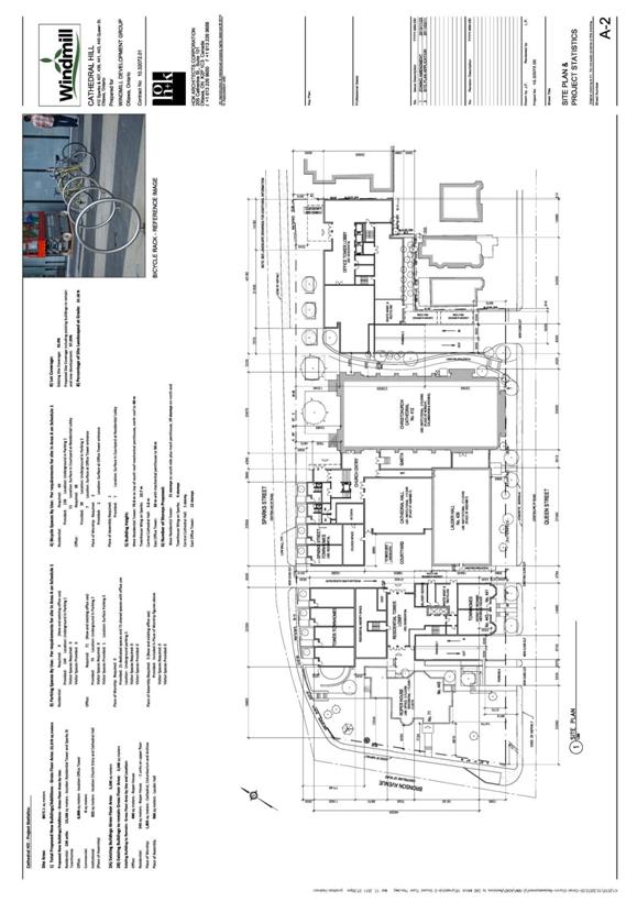
The subject site is approximately 0.8 hectares in area, with frontage on Sparks Street of approximately 145 metres, on Queen Street of approximately 125 metres and on Bronson Avenue of approximately 50 metres. There are five buildings located on the site including the Christ Church Cathedral, Cathedral Hall, Lauder Hall, Roper House and a semi-detached dwelling.
The site has a parking lot with approximately 65 parking spaces located between Christ Church Cathedral and the Lutheran Church and accessed from Sparks Street.
A second parking
lot for approximately 25 parking spaces exists between Roper House and
Cathedral Hall and is accessed from Queen Street. St. Peter’s Lutheran Church is located on the
eastern portion of the “Ecclesiastical Block” and a commercial parking lot is
located just south of the Lutheran Church at the north-west corner of Queen and
Bay Streets. The Garden of the Provinces
is located to the north of the property, on the north side of Sparks
Street. Several federal buildings are
located along Wellington Street, and the Ottawa River is approximately 340
metres north of the site. A range of
higher density development is located south and east of the site. Located on the west side of Bronson Avenue is
Bronson Park and further west is Lebreton Flats. Properties to the south and east are
generally zoned R5 (Residential Fifth Density), while those to the north and
west are zoned L1 or Community Leisure Facility.
Proposed Development Concept
The proposed development includes a 12-storey office
building, a 21-storey apartment building, and a new Cathedral Hall, with the
Cathedral, Roper House and Lauder Hall retained and incorporated into the
development. A portion of the
semi-detached building at 441-443 Queen Street will be retained and
incorporated into the apartment building.
The office building will be located at the north-east
corner of the subject property, where a parking lot currently exists. The office building is proposed to be 54
metres in height (including the mechanical penthouse) and may include a
commercial component at grade with uses such as a retail food store, retail
store, restaurant and/or personal service business.
The residential building will be located just east of Roper
House and will extend from Queen through to Sparks Street. The residential building is proposed to
be 73.6 metres in height (including the mechanical
penthouse) at the southern portion adjacent to Queen Street and 60 metres
at the north roof and will include 136 dwelling units, a four-storey townhouse
podium base along Sparks Street, and a new Cathedral Hall for the use of the
church.
An interior
courtyard is proposed as well as a series of pedestrian connections running
north-south between Sparks and Queen Streets.
Roper House will remain in its existing form and place but new land uses
within the building are requested as part of the zoning amendment including
dwelling unit, retail food store, retail store, restaurant and personal service
business.
All parking for the office and residential buildings as
well as the existing Church uses will be provided underground, with a total of
244 spaces proposed. 144 spaces will be
designated for the residential building including one car share space, while 25
will be designated for Cathedral uses and the remaining 75 time-shared between
the office and Cathedral uses. Access to
the underground parking is proposed from Queen Street. A vehicular drop-off area to the residential
lobby entrance is proposed along Sparks Street.
The building will be designed to LEED Platinum standards and
includes a number of sustainable features such as high efficiency HVAC,
lighting and electrical systems, Intelligent Building Automation Systems,
renewable energy generation such as solar photovoltaic and solar thermal,
district energy, geothermal and cogeneration opportunities, high performance
building envelope, solar shading devices, day lighting, water conservation
fixtures and greywater systems, stormwater harvesting, green roofs/walls, and
waste management strategies.
Existing Zoning
The western
portion of the subject site is zoned Minor Institutional I1A [332] Schedule
206. The eastern portion of the property
is zoned General Mixed Use GM [185] Schedule 85. The purpose of the Minor Institutional Zone
is to permit a range
of community uses, institutional accommodation and emergency service uses and
to minimize the impact of these minor institutional uses located in close
proximity to residential uses by ensuring that such uses are of a scale and
intensity that is compatible with neighbourhood character. The purpose of the General Mixed Use Zone is
to permit residential, commercial, institutional, or mixed use development and
impose development standards that will ensure that the uses are compatible and
complement surrounding land uses. The
associated Schedules 85 and 206 permit development with heights up to 21.5
metres.
The entire property is subject to a Heritage Overlay in the Zoning By-law, which requires that where a building is removed or destroyed it must be rebuilt with the same character and at the same scale, massing, volume, floor area and in the same location as existed prior to its removal or destruction. The Heritage Overlay regulates the size and location of any additions to existing buildings within the Heritage Overlay. Properties that do not contain existing buildings are subject to the underlying zoning. The Heritage Overlay also removes any parking requirement for the Christ Church Cathedral, Lauder Hall, and Roper House. The site is also contained within the Cathedral Hill Heritage Conservation District.
Purpose of Zoning Amendment
The Zoning
By-law Amendment is requested to permit relief from the requirements of the
Heritage Overlay and address a number of performance standards including height
and setbacks. The amendment proposed
would permit the following additional uses within the site currently zoned
minor institutional: dwelling units in the form of apartment dwelling, mid-high
rise and multiple attached dwellings.
Within Roper House, the following additional uses are requested:
dwelling units, personal service, restaurant, retail food store and retail
store. Within what is currently the
existing General Mixed-Use Zone, the amendment proposes to permit the following
additional uses: personal service business, restaurant, retail food store and
retail store.
Proposed Zoning
The application proposes to create a GM subzone specific to the subject proposal
which would include existing uses such as the place of assembly and place of
worship, but include additional uses such as dwelling units, office, personal
service, retail food store and retail uses.
The subzone would include a schedule to regulate setbacks and building
heights specific to the proposed development.
Zoning provisions are detailed in Documents 2 and 3.
DISCUSSION
Planning Act and the Provincial Policy
Statement
Section 2 of the Planning Act outlines those land use matters that are of provincial interest, to which all City planning decisions shall have regard.
The provincial interests that apply to this site include the appropriate location of growth and development and the promotion of development that is designed to be sustainable to support public transit and to be oriented to pedestrians.
In addition, the Planning Act requires that all City planning decisions be consistent with the Provincial Policy Statement (PPS), a document that provides further policies on matters of provincial interest related to land use development. The PPS contains policies which indicate that there should be an appropriate mix of uses to support strong, liveable and healthy communities.
The PPS promotes a range of densities and land uses and Section 1.1.3.2 requires that land use patterns facilitate the efficient use of land and resources, are accommodated by existing or planned infrastructure and minimize negative impacts to air quality and promote energy efficiency.
The proposed development complies with polices of the PPS in a number of ways. The development is on a site in the Central Area where sufficient infrastructure exists to accommodate the proposal, a mix of land uses are proposed, and the buildings have been designed to ensure energy efficiency. The provided landscape plan improves the streetscape environment with landscaped pedestrian links, with more than 40 additional trees proposed in addition to hundreds of shrubs, vines and perennials. The development is proposed in the Cathedral Hill Heritage Conservation District, a designated heritage conservation district, and where heritage resources within the District will be retained and integrated into the development scenario. Roper House has been retained in its original setting. In addition, significant space has been allocated to the west of the Cathedral spire to ensure its continued prominence on the streetscape and from a distance.
The proposed zoning allows for an increase of residential units, which will efficiently re-use land and contribute to a balanced community. Existing infrastructure is sufficient for the proposed development and the building is proposed to be designed to LEED Platinum level. The site is conveniently located near transit as well as nearby residential and commercial areas to allow for access by pedestrians and transit. The Department is of the opinion that the proposal is consistent with the matters of provincial interest as outlined in the Planning Act and PPS.
Official Plan
Central Area Designation
The subject site is designated as Central Area in the Official
Plan. The Central Area is the economic
and cultural heart of the City and symbolic heart of the nation. Policies promote the Central Area’s vital
role in the city, its distinct identity and heritage character, as well as the
primacy of the Parliament Buildings and other national symbols.
The Plan also aims to enhance the diversity and attractiveness of the Central Area by encouraging a broad range of land uses and day/night, year-round activities. This aim will be supported by the protection of residential neighbourhoods in and near the Central Area and an increasing number of downtown area dwelling units.
The Central Area designation requires that the Central Area Secondary
Plan and Downtown Ottawa Urban Design Strategy are implemented, which is
addressed in subsequent sections.
The designation requires that the visual integrity and symbolic primacy of the Parliament Buildings is protected, as addressed in the View Analysis section below.
The designation also requires that residential development contribute
to a sense of human scale, minimize sun shadow and maximize exposure of units
to direct sunlight, minimize undesirable wind conditions, respect privacy for
proposed and adjacent units, provide usable amenity space, create an
identifiable entrance and provide appropriate landscaping.
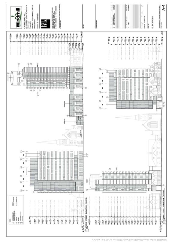
The proposed development has responded to the Central Area policies of the Official Plan by designing a residential building that is slimmer and taller than permitted by the zoning by-law in order to minimize the scale of shadowing to the north (chiefly the Garden of the Provinces) and to minimize impact on residential units to the south. A Pedestrian Level Wind and Snow Drifting Study has been completed indicating that with targeted mitigation, the wind conditions at all ground level areas of the development site will be acceptable or marginally acceptable for their intended pedestrian use throughout the year. Usable amenity space is proposed at the interior courtyard and the site is adjacent to Bronson Park and the Garden of the Provinces. The site focus is the identifiable entrance of the Christ Church Cathedral where a gathering space has been defined in front. The proposed landscape plan includes pedestrian links, more than 40 additional trees as well as hundreds of shrubs, vines and perennials.
The Central Area policies of the Official Plan direct the City to improve and enhance the pedestrian environment by providing pedestrian amenity space, enhancing circulation systems, improving landscaping, and providing sheltered and sunlit seating areas. The development proposes a series of new pedestrian linkages from Queen to Sparks Street including a central courtyard space which meets the intent of the Central Area designation in improving the pedestrian linkages. Ground level lighting or low level wall lighting from adjacent buildings will be included in pedestrian pathways and the introduction of a residential component to the site ensures “eyes on the street” and enhances pedestrian safety. Security monitoring will also be part of the proposed development. Walking, cycling and public transit are a priority in the Central Area where policy speaks to providing mid-block connections to pedestrian corridors, just as is proposed for the subject site. The proposed development will also include 177 bicycle parking spaces located in the courtyard, surface pedestrian spaces and the underground parking garage.
The Official Plan requires that the established architectural integrity
of existing buildings and streets be preserved by ensuring buildings are sited
to minimize sun shadowing on public open spaces and pedestrian corridors. The proposed residential building is a tall
narrow built form which ensures minimal shadowing impacts on the Garden of the
Provinces located to the north than would a wider shorter building.
To preserve this architectural integrity, the provision of at-grade street-oriented uses fronting on the sidewalk is to be ensured, accomplished through the proposal to provide townhouses fronting on Sparks Street and possible new land uses within the existing Roper House to animate the pedestrian environment.
While the current site accommodates surface parking, the development
proposes all parking to be located underground, which is in keeping with the
Central Area policy requiring parking to be located above or below grade. The public right-of-way where currently used
for access to existing surface parking lots, will be reclaimed for pedestrian
spaces and landscaping.
Section 2.2 of the Official Plan speaks to concentrating growth within the designated urban area to allow for a pattern and density of development that supports transit, cycling and walking as viable alternatives to the private automobile. The subject site is located approximately 200 metres from the future Downtown West transit station and is one block from current transit and so future residents and employees will have access to transit as an alternative to the car.
The Official Plan calls for new development to be guided by design criteria. The Official Plan calls for the liveability of the residential areas within the Central Area (Upper Town, Lowertown and Sandy Hill West) to be significantly improved, and their heritage resources protected and enhanced. In the Central Area, heritage resources must be protected through heritage conservation, and enhanced through new development which respects and complements nearby heritage buildings. By integrating the existing retained heritage resources with the proposed new development, the heritage policies of the Central Area have been complied with.
Section 2.5.1 Compatibility and
Community Design
The Central Area designation requires that development have regard for the compatibility criteria found in Section 2.5.1 of the Official Plan. Compatible development means development that, although not necessarily the same as or similar to existing buildings in the vicinity, nonetheless enhances an established community and coexists with existing development without causing undue adverse impact on surrounding properties. It ‘fits well’ within its physical context and ‘works well’ among those functions that surround it.
The first design objective of
Section 2.5.1 is to enhance the sense of community by creating and
maintaining places with their own distinct identity. The high-quality architecture proposed for
the development and the urban design analysis undertaken as part of the Design Review
process ensure that design creates a distinctive space and enhances its
nationally significant surroundings. By
animating a sidewalk that frames a park, this project achieves a dual objective
of contributing to enliven a streetscape that is presently punctured by parking
lots, and contributes to increasing the dynamism of the Garden of the Provinces
by adding residents who may use that park as outdoor recreation space.
A
related principle associated with the first design objective (as found in Annex
3 – Design Framework of the Official Plan) is to “Support the overall image of
Ottawa as the Nation’s Capital”. This
proposal accomplishes the retention and restoration of key heritage assets
including the significant Anglican Cathedral, while sensitively integrating new
buildings with a mix of uses that contribute to the repopulation of this
block.
The
architecture of the tower is a unique statement of urban dynamism on the skyline,
while not detracting from the protected views of Parliament. The pedestrian spaces are reflective of
similar and very successful spaces elsewhere in the downtown. The proposal enhances Ottawa’s image as a
capital city that is becoming a national leader in urban regeneration, which is
an appropriate role for Ottawa as capital of an urbanized country.
Design
should define quality public and private spaces through development. The subject proposal through the proposed
location, scale and massing has enclosed the courtyard space while ensuring a
continuity of street frontage along both Queen and Sparks Streets. Important vistas are addressed through a view
analysis.
Design
should create places that are safe, accessible and easy to get to and move
through. The pedestrian connections and
courtyards proposed will allow for a level of pedestrian connectivity in the
area that previously did not exist and can be used all hours of day and night
by the public. Safety has been ensured
through lighting, introduction of a residential component and security
monitoring.
Development
should respect the character of existing areas.
The proposed development complements and enlivens the surroundings. The introduction of new residential units
will bring new pedestrian activity to the site in combination with additional
land uses. Architectural style and
innovation is encouraged and has been accomplished. By retaining the Cathedral, Lauder Hall, Roper
House and a portion of the semi-detached building, the institutional character
of the block is maintained and complemented by the addition of residential and
office uses. The scale of building is
compatible with surrounding blocks which include a 12- and 16-storey
residential building directly to the south.
The two-storey townhome podium responds to the rhythm, size, massing and
proportions of the existing low-rise residential within the block.
Adaptability
and diversity in place is encouraged through the Official Plan. The proposed development is a compact form, and
the proposed land uses allow for flexible adaptive re-use of designated
heritage resources.
Section 4.11 Compatibility
To arrive
at compatibility of scale and use will demand a careful design response, one
that appropriately addresses the impact generated by infill or intensification.
Consequently, the issue of ‘context’ is a dominant theme of the Official Plan
where it speaks to compatibility and design.
a. Traffic: Roads should
adequately serve the development, with sufficient capacity to accommodate the
anticipated traffic generated. A Community
Transportation Study was prepared by Delcan dated November 2010 and concluded
that high non-auto modal share during peak periods is expected as the site is
located close to rapid transit. The
impact on area intersections and new trips to the site is negligible and
traffic signal control and auxiliary turn lanes are not warranted.
b. Vehicular Access: The
location and orientation of vehicle access and egress should address matters
such as the impact of noise, headlight glare and loss of privacy on development
adjacent or immediately opposite. The underground
parking garage will be accessed via Queen Street. The proposed driveways will
minimize automobile movement disruption, improve traffic flows, contribute to a
safer pedestrian environment, and separate car access to the two main buildings.
Noise and headlight glare impacts will generally be absorbed internally and
mitigated on adjacent properties through the provision of the vehicular
drop-off area.
c. Parking Requirements: The
development should have adequate on-site parking to minimize the potential for
spillover parking on adjacent areas. Parking proposed will exceed the Zoning By-law
requirements, and transit use, cycling, car-sharing, and walking will be
encouraged on the site through the provision of a car-share parking space, the
provision of 177 bicycle parking spaces, enhanced pedestrian connections and
the proximity to rapid transit stations.
d. Building Height and
Massing: New buildings should have regard to the area context - the massing and
height of adjacent buildings, and planned function for the area. Development to
the south and east of the site is generally medium to high profile and so the
proposed 12- and 21-storey buildings are compatible with area context. Design principles have been applied to the
site including creating a sense of human scale at the ground level through pedestrian
connections, setbacks, and compatibility with existing heritage buildings.
e. Pattern of the Surrounding
Community: The building heights are compatible with those in the area and the
mass of the residential building has been proposed in a narrow form to minimize
impacts. Setbacks proposed ensure
compatibility and enhancement of existing heritage buildings.
f. Outdoor Amenity Areas: The
development should respect the privacy of outdoor amenity areas of adjacent
residential units and minimize any undesirable impacts. The taller proposed building has been located
further from residential buildings located to the east of the subject site so
that taller narrow shadows fall largely on the subject site itself and have
minimal impact on those adjacent. The
buildings have been set back from the Sparks Street lot line in order to permit
landscaping and streetscaping of the space in front of the Cathedral and office
building. The proposed development will
provide meaningful landscape and amenity areas, including an interior courtyard
and church garden, perimeter landscaping and the retention of open space
adjacent to Roper House. Private amenity
area in the form of tempered summer terraces will ensure minimal impact on
adjacent dwellings.
g. Loading Areas, Service
Areas, and Outdoor Storage: The operational characteristics and visual
appearance of loading facilities, service areas (including garbage), parking
and areas for the outdoor storage of goods or materials should be mitigated
using a variety of methods. Loading,
service areas and garbage facilities will be provided within the underground
parking facilities, in order to minimize disruption to adjacent properties.
h. Lighting: The potential for
light spillover or glare from any lighting source onto adjacent light-sensitive
areas should be avoided or mitigated.
Lighting proposed will be ground level or low-level on adjacent building
walls.
i.
Noise and Air Quality: The development should be located and designed to
minimize the potential for significant adverse effects on adjacent sensitive
uses related to noise, odours, and other emissions. The proposed uses are not significant noise
generators and are consistent with those existing in the area, and as described
above, all parking and service areas are proposed within underground parking
areas.
j.
Sunlight: The development should minimize shadowing on adjacent
properties, to the extent practicable, particularly on outdoor amenity areas,
through the siting of buildings or other design measures. Shadows from the building fall to north
moving from west to east as the day progresses. By proposing the taller
residential tower as a slim and tall design means that resulting shadow impacts
are minimized on the Garden of the Provinces.
In the summer months, the shadows just barely reach the Garden of the
Provinces in the morning and by afternoon do not impact the Garden at all. The provided sun-shadow study illustrates
that shadows impact only lands to the north and federal buildings in the winter
months and that adjacent downtown residential buildings are not affected by any
shadow impacts by the proposed development.
k. Microclimate: The
development should be designed to minimize adverse effects related to wind,
snow drifting, and temperature on adjacent properties. A Pedestrian
Level Wind and Snow Drifting Study has been completed indicating that with
targeted mitigation, the wind conditions at all ground level areas of the
development site will be acceptable or marginally acceptable for their intended
pedestrian use throughout the year. Minimal surface parking and
the introduction of new landscaping will reduce heat island effects. Possible mitigation measures will be dealt
with through the site plan control process.
l.
Supporting Neighbourhood Services: The development should contribute to
or be adequately served by existing or proposed services and amenities such as
health facilities, schools, parks and leisure areas. The proposed development is within walking
distance of a wide range of community services such as parks, schools,
emergency services and a variety of commercial/service uses within the Central
Area. Six parks are located within one
kilometre of the site; a large grocery store is approximately one kilometre of
the site. Of schools with the Ottawa
Carleton District Public School Board, there are two elementary schools within
two kilometres of the site and two high schools within three kilometres of the
site. The addition of new residents to
this Section of downtown will contribute to the strengthening of local demand
for retail and services, which would benefit the entire area by being accessible
on foot.
View Analysis
The Official
Plan requires that the City protect the visual integrity and symbolic primacy
of the Parliament Buildings as seen from Confederation Boulevard and the main
approach routes to the Central Area depicted as key views on Annex 8A. The subject site is outside the key views of
Annex 8A, but is partially within an area of foreground height control and
partially within the area of background height control. The Plan limits support for increase in
building heights to where the increased height will not visually mar the
silhouette of the Parliament Buildings or dominate the Parliament Buildings or
other national symbols.
Although
the subject site is outside of the key views indicated, a view analysis was
undertaken to ensure that the view of the Parliament Buildings from several
perspectives is not visually marred. The
view analysis is included in this report as Document 6. Key views 11 and 5 illustrate that from these
points (as well as the majority of key views) the Parliament Buildings and the
subject site cannot be viewed in the same place. Key view 2 is furthest east and Key view 16
is furthest west, both of which illustrate that the Parliament Buildings are
not visually marred by the proposed development.
The
subject site is outside of the boundaries of Annex 8B, which is Central Area
Maximum Building Heights/Angular Planes.
However the closest location to the subject site that is included in
Annex 8B is the south-west corner of the intersection of Lyon and Sparks
Streets where the above sea level of height maximum is 153 metres. The south-west corner of the intersection of
Lyon and Queen Streets has a maximum height above sea level of 155.8
metres.
The
apartment building of the proposed development, while outside of Annex 8B, is
proposed at an above sea level height of 146.6 metres at the highest point of
the mechanical penthouse, lower than the closest adjacent height maximums set
out in Annex 8B.
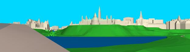
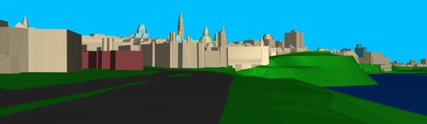
The
Central Area policies of the Official Plan require that the City protect the
views of the Parliament Buildings from locations in Beechwood Cemetery. The subject site is contained within the
background and so an analysis was undertaken to ensure that the proposed
buildings do not visually mar the background silhouette view of the Parliament
Buildings. The proposed apartment
building was modified from the initial submission to reduce the height of the
northern portion of the roof to 60 metres in order to ensure views from
Beechwood Cemetery are not impacted. A
view from Beechwood Cemetery is included in Document 6.
Central Area Secondary Plan
The
Official Plan requires ensuring that development applications have regard for the
Central Area Secondary Plan policies to enhance the physical character,
identity and unique heritage resources of the Central Area’s heritage
conservation districts.
The intent
of the proposed development is to retain all heritage buildings on the site and
incorporate new development into the site in a compatible manner in order to
ensure the long term viability of the heritage resources.
Within the
Central Area Secondary Plan, the subject site is identified within the Upper
Town Area, and is a unique heritage district.
The subject site is within a transitional entry area to Upper Town and
the Core, and is identified as predominantly residential area. The Upper Town area is identified as
predominately medium and high profile development, while the Cathedral Hill
Heritage district is identified as predominantly low-to medium profile
development, requiring a transition to the Central Area and sensitivity to the
heritage character of the district.
The
development has proposed a slender residential tower in order to create space
around the heritage assets of the site and to be sensitive to the heritage
character of the district. While the
proposed buildings are considered high profile, their footprint is limited to 22%
coverage and so the Heritage district as a whole still remains predominantly
low to medium profile.
The
Secondary Plan speaks to a pedestrian pathway system, which has been included
in the proposed development to provide through block access in a number of
locations between Queen and Sparks Streets.
Escarpment
Area District Plan
The western portion of the subject site is
contained within the Area of Influence on the Escarpment Area District
Plan. The plan identifies Cathedral Hall
as a potential re-development site and the property at 412 Sparks Street as a
development site but also acknowledges the current zoning and heritage
designation. The District Plan states
that beyond current policies and
zoning, it should be recognized that modern operating realities of the existing institutional use coinciding with their need to
generate income for their own programmes indicates that current
standards should be reviewed to allow greater flexibility.
Related
to built form of new development, the District Plan identifies the need to
enhance the high-rise character of the community with more pedestrian friendly
development. Towers should have strong
podium bases in order to protect views, mitigate sun shadow impacts and
eliminate blank walls on the street.
The plan
identifies Cathedral Hill as being suitable for sensitive redevelopment, in the
context of a block-wide strategy that allows for the protection of the heritage
buildings.
The
proposed development complies with the policies of the Escarpment Area District
Plan by improving the pedestrian streetscape, proposing strong podium base on
the apartment building, and ensuring that the plan considers the entire District
and the incorporation of heritage buildings.
While the purpose of development is outside of the planning review, it
is a reality that the existing Christ Church Cathedral is proposing development
in order to ensure retention of the heritage resources of the block, a
recognized concept in the Escarpment Area District Plan.
Downtown
Urban Design Strategy 2020
The Official Plan directs the City to implement the Downtown Ottawa Urban
Design Strategy in the Central Area to promote the liveability of the downtown.
Within the Design Strategy, the subject site is identified as the Downtown West Precinct. This district contains key historic buildings. Streetscaping and public realm improvements should capture the historic importance and grandeur of the churches in this location and new buildings should support a podium base and be setback from the sidewalk. The strategy recognizes Cathedral Hill as a primarily residential district that supports only limited commercial uses. This area is unique as it is one of the ‘apartment neighbourhoods’ in downtown Ottawa, making it an ideal location for higher-density residential infill
The proposed development complies with the Downtown Ottawa Urban Design Strategy 2020, and as the guiding principle of development was to preserve key historic buildings, space was provided around the Christ Church Cathedral in order to capture its importance and grandeur. As well, the new residential building proposes a podium base setback from the sidewalk on Sparks Street.
Urban Design Guidelines for High-Rise Housing
The Urban Design Guidelines for High-Rise Housing guide proposes development to provide compatibility in context, coordinate parking, services, and transit into the site, mix uses and open spaces, contribute to urban living and pedestrian-friendly streets, and provide a response to the physical environment and microclimate through design.
The guidelines promote high-rise buildings that contribute to views of the skyline and enhance image of the city. The proposed development complies with the guidelines by ensuring that the new buildings are compatible with the existing heritage buildings, that parking and services are provided underground, that additional land uses are added to the mix on the site, that a pedestrian-friendly streetscape is provided, and that a slim tower design is used to minimize microclimate impacts. The proposed development has proceeded through the Design Review process, as detailed in Document 7, and the architecture is of a high quality to ensure that views of the skyline are enhanced.
Heritage Considerations
The Central Area designation of the Official Plan requires that the City enhance the appearance and liveability of the Central Area by designating heritage buildings and working with owners to restore and maintain heritage buildings. An application for new construction in a Heritage District was submitted on April 6, 2011, proceeded to the Ottawa Built Heritage Advisory Committee on May 5 and is being considered as a separate report to Planning Committee.
Concurrent Application
An application for site plan control was submitted (D07-12-11-0047) on March 15, 2011.
Summary
In summary, the proposed development ensures conservation of significant heritage resources, is designed to be energy efficient and proposes a mix of land uses in accordance with the direction of the Provincial Policy Statement.
A view analysis has evaluated key views and the Department has concluded the proposed development will not visually mar the view of Parliament Hill. A design analysis and review has led to minimal impacts on adjacent properties, heritage resources have been integrated, high-quality architecture is proposed, the pedestrian environment is enhanced and parking is located below grade all in accordance with the Official Plan.
The proposed development will enhance the high-rise community with a strong podium base and pedestrian-friendly environment as per the Escarpment Area District Plan. The Downtown Urban Design Strategy 2020 recognizes this site as ideal for higher density residential infill and the proposed development has captured the historic importance and grandeur of existing churches accordingly. The proposed development will contribute positively to the skyline of the Central Area of Ottawa with minimal impacts on adjacent properties, and as such the Department recommends approval of this Zoning By-law amendment.
ENVIRONMENTAL IMPLICATIONS
An Environmental Impact Study was prepared to address the potential direct and indirect impacts of a new condominium building and construction on an active peregrine falcon nest on the Delta Hotel at 101 Lyon Street in downtown Ottawa. The proposed development is located more than 230 metres from the nest site. Based on consultation with falcon experts, literature review and observations, the study concluded that there will be no negative impacts on the regulated habitat of this threatened bird provided that recommended mitigation measures are in place, which can be addressed through conditions on the site plan agreement.
Although the Phase I Environmental Site Assessment identified concerns including former coal chutes on several buildings and a fuel oil aboveground storage tank, the geotechnical investigation revealed no evidence of contamination in any of the boreholes. Therefore further investigation is not warranted and any limited areas of contamination, if encountered, can be removed and disposed off-site at the time of construction of the underground parking. The site plan agreement will contain a condition to ensure this occurs.
RURAL IMPLICATIONS
N/A
CONSULTATION
Notice of this application was carried out in accordance with the City's Public Notification and Consultation Policy. Response to the Public Consultation comments is provided in Document 8
COMMENTS BY THE WARD COUNCILLOR(S)
1.
Throughout this
process it has been asserted by the applicant and their agents that this
proposal maximizes the overall existing floor space and density that is
available on the site by shaping into two tall towers. Therefore I wish to
know:
-
What is the
total allowable f.s.i. permitted under the current zoning?
-
What is the
total f.s.i. of the current proposal for a 24-storey condo, 20-storey office
building, and low rise portions?
2.
Under the
projected implementation of Section 37 of the Planning Act, the uplift in value
arising such increase in height would be calculated, and an exchange in
community benefits would be requested from the City. Heritage conservation is
an eligible community benefit.
-
What is the
total uplift in value achieved through this increase in building height?
-
What is the
monetary value of the heritage conservation component of this project?
A response to these comments is provided in Document 8.
LEGAL/RISK MANAGEMENT IMPLICATIONS
If this rezoning application is appealed to the Ontario Municipal Board, it is anticipated that a three-to four-day hearing would result.
Should the recommendation be refused reasons will have to be provided. If an appeal of the refusal were to occur, an external planner would need to be retained at an estimated cost of $15,000.00. Additionally, if circumstances were to require that outside legal counsel be retained to undertake the Ontario Municipal Board hearing, this would cost an estimated $30,000.00.
CITY STRATEGIC PLAN
The proposed development and planning applications align with the City Strategic Plan in that it is an example of leading edge urban design, has integrated new growth with the established community, and contributes toward achieving a 30 per cent modal split by 2021.
TECHNICAL IMPLICATIONS
FINANCIAL IMPLICATIONS
There are no direct financial implications associated with this report.
APPLICATION PROCESS TIMELINE STATUS
This application was processed by the "On Time Decision Date" established for the processing of Zoning By-law amendment applications.
SUPPORTING DOCUMENTATION
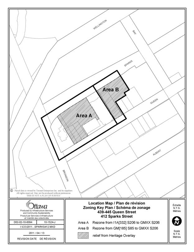
Document 1 Location Map
Document 2 Details of Recommended Zoning
Document 3 Schedule 206
Document 4 Site Plan
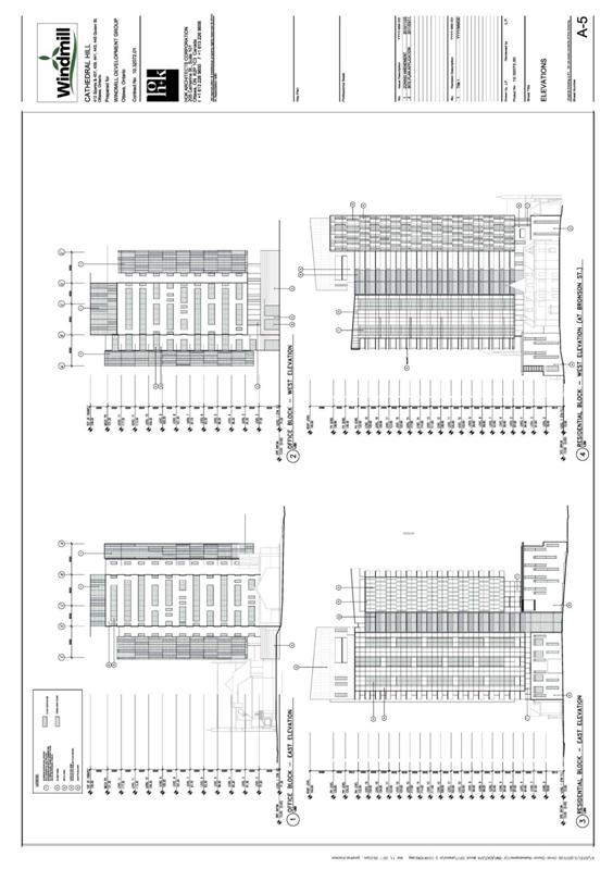
Document 5 Elevations
Document 6 View Analysis
Document 7 Urban Design Review Panel Details
Document 8 Consultation Details
DISPOSITION
City Clerk and Solicitor Department, Legislative Services to notify the owner, applicant, OttawaScene.com, 174 Colonnade Road, Unit #33, Ottawa, ON K2E 7J5, Ghislain Lamarche, Program Manager, Assessment, Financial Services Branch (Mail Code: 26-76) of City Council’s decision.
Planning and Growth Management to prepare the implementing by-law, forward to Legal Services and undertake the statutory notification.
Legal Services to forward the implementing by-law to City Council.
LOCATION MAP DOCUMENT
1
DETAILS OF RECOMMENDED ZONING DOCUMENT 2
1. Amend the Zoning Map of By-law No. 2008-250 as follows:
- Area A on Document 1 rezoned from I1A[332] S206 to GMXX S206
- Area B on Document 1 rezoned from GM[185] S85 to GMXX S206
- Remove the Heritage Overlay from the shaded areas shown on Document 1
2. Amend Part 17 - Schedules of By-law No. 2008-250 as follows:
- amend Schedule 85 to remove 412 Sparks Street and 439 Queen St.
- delete the existing schedule 206 and replace it with Document 2
3. Amend Section 188 of By-law No. 2008-250 to add a new General Mixed Use Subzone as follows:
GMXX SUBZONE - CATHEDRAL HILL
(XX) In the GMXX Subzone:
(a) only the following uses are permitted:
apartment dwelling, mid-high rise
columbarium
dwelling units
library
multiple attached dwelling
office
personal service
place of assembly
place of worship
restaurant
retail food store
retail store
(x) subsection 187(3) does not apply
(x) retail food store, retail store, personal service and restaurant uses are only permitted in shaded areas on Schedule 206,
(x) dwelling units may take the form of an apartment dwelling, mid-high rise attached to non-residential buildings and multiple attached dwellings attached to non-residential buildings,
(x) despite the definition of library, a library includes a private library and archives,
(x) yard setbacks are as per schedule 206,
(x) maximum building heights are as per schedule 206,
(x) landscaped areas are as per schedule 206,
(x) all contiguous lands zoned GMXX are considered one lot for zoning purposes.
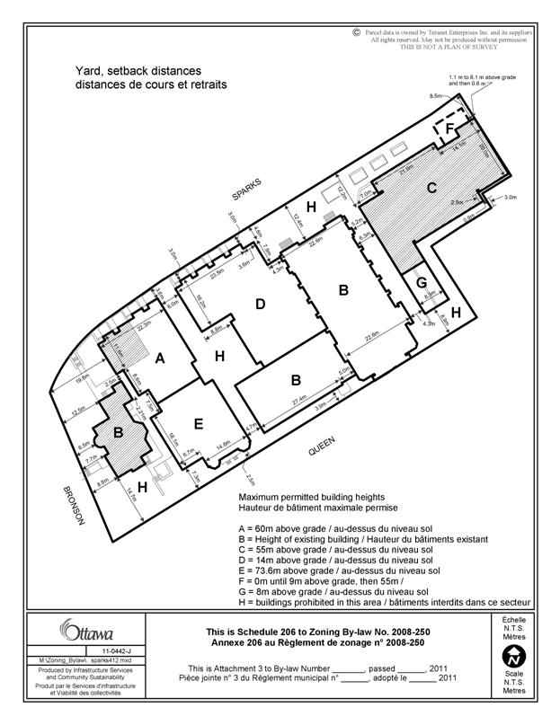
SCHEDULE 206 DOCUMENT
3

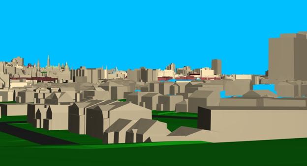
SITE PLAN DOCUMENT 4
ELEVATIONS DOCUMENT 5
VIEW ANALYSIS DOCUMENT
6
Official Plan Annex 8A
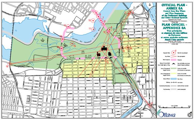
View from Point 11:

View from Point 5:
View from Point 2:
View from Point 16:

View from Beechwood Cemetery:
URBAN DESIGN REVIEW PANEL DETAILS DOCUMENT 7
The proposed development was subject to review by the Urban Design Review
Panel. Pre-consultations were held on
December 2, 2010, January 6, 2011, and February 3, 2011. Formal Design review took place on April 7,
2011.
The December 2nd pre-consultation resulted in the following
alterations:
·
Staff undertook
a detailed view analysis as per key views identified in the Official Plan
·
The north face
of the residential tower was stepped back
·
The townhomes
were setback further into the site from Sparks Street and
·
The urban
streetscape evolved to further consider the Lutheran Church by setting the
proposed office building back from Sparks Street and increasing the plaza space
which opens to the Christ Church entry
·
Introduced
pavers on Sparks Street to provide visual link to the Garden of the Provinces
The January 6th pre-consultation resulted in the following
alterations:
·
The views from
Beechwood cemetery were analyzed and addressed by lowering the northern portion
of the residential tower
·
To improve the
relationship of the site to the Lutheran Church, accesses were directed to
Queen Street
·
A meaningful
portion of the semi-detached building on Queen Street was incorporated into the
residential tower
The February 3rd pre-consultation resulted in the following
alterations:
·
Building facades
were explored with the intent to provide calm and clean treatments, while
allowing dramatic curving forms
·
The verticality
of the Cathedral itself was expressed through the proposed tower façade
·
Enclosure at the
front entry of the Church was setback and made transparent.
·
The office tower
footprint was revised to provide a stepped pattern to reflect the historic land
patterns and lots
·
The landscape
plan was developed to integrate the new urban form with Roper House and enhance
pedestrian connections and the courtyard
Formal Review
The Formal Design Review process took place on April 7th,
2011 and resulted in the following comments from the Panel:
General
Comments
- The Panel has appreciated working with the design and applicant team on this project and has found the evolution of this design very rewarding.
- This is one of the most important sites in
Ottawa and the most significant site that the Panel has had the
opportunity to review up to this point. The extra care and attention the
applicant has taken to consider and incorporate the Panel’s
recommendations is appreciated.
- The Panel commends the applicant on their
presentation and their thoughtful urban design analysis. While the Panel
is generally pleased with the direction of the project, there are a number
of contextual issues, including elevations and landscaping issues, which
require further development.
Landscape
and Public Realm
· The Panel would have liked to see more detail about the design and intent for the open spaces and the public realm. The Panel notes that landscaping needs to be examined more closely, including the selection and use of proposed materials and planting.
· The Panel notes the importance of looking at the relationship between the landscape and the larger context. There is some concern that the landscaping strategy is somewhat fragmented, particularly as it relates to a strategy concerning street trees. The Panel stated that if the crabapple trees in front of the Cathedral are retained there should be a clear rationale for this decision. The Sparks Street sidewalk should be lined with large trees (not three small trees) that open up in front of the Cathedral plaza and continue across the front of the commercial plaza, connecting to the grid of trees to the north of the site. Large street trees, such as a number of native maple species, should be planted in front of the townhomes and continue along the block.
· The Panel notes that there should be a hierarchy of outdoor spaces with the forecourt in front of the Cathedral being the most important urban space on site that is supported by all the other urban spaces. The forecourt is an integral component to the success of the project and should be landscaped appropriately. Through landscaping, it can also be linked to the Garden of the Provinces and Territories. The office and commercial tower landscape should be supplementary to this primary space.
· The south side of Queen Street should be examined as the applicant develops the landscape strategy for the site’s facing edge. The street tree treatment of the landscape along the north Queen Street edge should complete and complement the existing landscape on the south side of Queen Street.
· Sensitivity to landscaping details will be important to the success of connecting spaces. For example, the Panel suggested that the design of the narrow sliver of the Philosopher’s Walk could be in some way married to the treatment of the parking ramp (e.g. through lighting or hardscape strategies).
· The Panel suggested the possibility of providing a series of steps up from the Escarpment Park, west of the Garden of the Provinces and Territories to the projecting escarpment wall opposite the Cathedral. The Panel suggested that this be seen as compensation for the greatly increased density on the site and would create valuable linkages both for the site’s residents and future pedestrian movement linking between LeBreton open spaces and Sparks Street itself (as proposed by the City of Ottawa’s Downtown Ottawa Urban Design Strategy).
·
The Panel is not satisfied with the landscape
treatment to the west side of Roper House.
Although a lawn in the past, there could be a more imaginative way of
using landscaping to enhance this part of the site. The Panel notes that the
Roper House lawn should be considered as part of the park to the north and that
a rich landscape solution should be developed that could serve to connect the
site to the Garden of the Provinces and Territories. The Panel recommends that the applicant
examine possibilities for this landscape as they develop detailed plans of the ground
plane.
· A series of visual cues could be developed to help tie this site together with its surroundings. The Panel recognizes that the small spaces are evolving in terms of their responses to their respective adjacent uses; however, it is important to ensure these spaces are linked cohesively and give primacy to the Cathedral forecourt.
Built Form and Materiality
· The Panel is fairly comfortable with the proposed material palette. The Panel encourages the applicant to translate the simplicity of their sketches into the refinement of design and material selection for each building. The Panel also suggests the creation of 1:50 elevations, in particular for the first few floors, to help in the final selection of materials and design refinements.
· The proposed stone base of the office building and residential town houses is moving in the right direction. The sense of the Panel is that above the stone base, the tower buildings should visually disappear into the sky and be relatively simple; the Panel is wary of tall, heavy elements competing with the Cathedral’s prominence.
· As the design of the towers evolves and materials are considered in more detail, the Panel suggests that the use and impact of darker colour choices should be carefully considered, especially when seen above or immediately beside key heritage buildings.
· The Panel is somewhat concerned about the idea of the “set of three” dominant vertical elements and feels that the Cathedral and its spire should be the uniquely dominant element on the site. The Panel would like some assurance that the prominence of the Cathedral and its spire is in fact what the applicant is proposing.
· The Panel would like a better sense of how the selected materials and forms of the buildings will marry themselves together and to the site. The Panel encourages the applicant to explore further simplifying the vocabulary and palette of the two taller buildings.
· The design resolution of the curved element at the top of the residential tower appears to be too dominant and heavy and should undergo some refinement.
Invitation
Back
· While the project is moving in the right direction and has come a long way from the earlier presentations, the Panel is interested in reviewing further evolutions of the design.
· The Panel invites the applicant back for further review but understands that a development application has been submitted and is conscious of the related time constraints. Given this, a small sub-group of the Panel could be available to the applicant, outside of the normal monthly meeting times, to further review the project.
· In such a situation, the Panel would find the following additional drawings helpful in understanding the proposed development:
o Larger scale elevation details (1:50 scale, coloured elevations of first few floors)
o A series of pedestrian level drawings of the courtyard spaces and streetscape at human scale, including from the south side of Sparks Street. This could perhaps be accomplished using the applicant’s Sketch Up model.
Response:
The comments arising from the formal review are related to landscaping,
materials and details that will all be addressed through the ongoing
application for Site Plan Control.
The applicant has presented to the Urban Design Review Panel four times
and is not required to appear again, but the Department recognizes that there
may be continued evolution of details related to the site plan application.
CONSULTATION DETAILS DOCUMENT 8
NOTIFICATION AND CONSULTATION PROCESS
Notification and public consultation was undertaken in accordance with the Public Notification and Public Consultation Policy approved by City Council for Zoning By-law amendments. An information session was also held at the Cathedral Hall by the applicant on December 9, 2010 prior to the submission of the applications.
SUMMARY OF PUBLIC INPUT
Height/Scale:
·
Height/volume of the condo building
overpowering/overwhelms the Cathedral steeple
·
The height/volume of the office building will
overshadow/overwhelm the Cathedral
·
Dwarf the Anglican and Lutheran Churches
·
Request for taller form with smaller footprint to
retain views for 434 Queen Street
·
3-4 storey buildings are more appropriate
·
Height of residential building is out of proportion
·
Heights proposed are 3.4 to 3.7 times higher than
current allowable heights
·
No building higher than 7 storeys should be allowed on
site
·
Apartment building should be limited to 17 storeys.
·
Objection to any zoning changes that increase height
or width
·
Height restrictions should remain as that is what I
was told when I bought my unit
·
We were under the impression that there would be no
high-rise buildings on the Ecclesiastical Block.
·
The City needs to stand up united against what
developments call progress by erecting even taller and narrow structures.
Response:
The Department recognizes that the proposal is significantly taller than the current buildings on the block. The proposal for increased heights has been evaluated in terms of impact on the adjacent heritage buildings, the block as a whole, and adjacent properties. View analysis was undertaken by City staff to determine how increased height would impact far away views including the protected view from the Beechwood Cemetery. It was noted that from many vantage points in the city, the impact of increased height on the block was negligible. The view from Wellington Street and the Garden of the Provinces, while not included in the protected views in the Official Plan, was an important one for the Heritage Conservation District. From that perspective, it was determined that maintaining horizontal space to the west of the Cathedral was an important element for the Cathedral retaining its prominence on the Block.
The other part of evaluating impact was consideration of the pedestrian experience at the streetscape or ground level. To that end, design elements ensure that the proposed building serves to enhance the heritage elements of the site.
The proposed office building has been setback from the front property line 8.5 metres at grade in order to ensure that St. Peter’s Lutheran Church is a visible element along Sparks Street. The setback increases to 12.48 metres in front of the Christ Church Cathedral to create a forecourt function. The proposed townhouses remain low west of the Cathedral and are stepped back in increments to wrap around Roper House. Landscaping is used to define the pedestrian realm as it wraps around Sparks Street to Roper House on Bronson. A tall narrow form of building minimizes impacts on adjacent properties and allows for heritage resources to retain prominence.
Heritage:
·
Height and mass not appropriate given zoning and
heritage overlay
·
Request to step back buildings from Queen and retain
semi-detached building. At a minimum the
facade of the building should be saved.
·
Removing structures from the area will diminish the
heritage characteristics and adding new buildings would destroy the heritage
look and feel of the area.
·
Building next to Church will decrease its visibility
·
Heritage overlay should be retained for Cathedral,
Roper House and Lauder Hall.
·
Property should remain within the Heritage
Conservation District
·
Object to the loss of heritage designation
·
This is a valuable heritage site and should remain as
such
·
Why have a heritage designation when it is removed
when a new property is proposed?
·
St. Peter’s church needs as much concern and attention
as Roper House
·
Architecture does not contain any elements that would
link the ‘old’ and the ‘new’ buildings
·
The proposed development should blend in with the
Heritage look of Roper House and the Cathedral
·
City of Ottawa should be following what the Federal
Government is doing with historic and heritage buildings downtown; protecting,
restoring and enhancing them
·
Canadian Heritage needs to be preserved. Building
commercial and residential buildings on heritage property is completely counter
to heritage preservation.
·
Destroys the historical significance of the
Ecclesiastical Block
·
The narrow building on Queen (assuming the destruction
of the semi-detached dwelling) will destroy the rhythm and peacefulness created
by the interplay between Roper House, Lauder Hall and the semi-detached
dwelling.
·
Property consultation with the Built Advisory
Committee, with Heritage Ottawa potentially and definitely conservation experts
need to be followed.
·
Specifically on heritage preservation, we
are concerned that the spectacular nature of the ecumenical buildings, and the
resulting amount of attention paid to them, could diminish the amount of
attention paid to the row houses on the property, which also have heritage
value. The entire parcel is identified as valuable from a heritage
perspective and the Queen Street side is blessed with a continuous line of
historic buildings from Roper House to the Cathedral. We ask that every
effort be made to preserve all of those buildings.
Response:
The
Department has worked with the applicant to ensure the partial retention of the
semi-detached dwelling on Queen Street and all other heritage buildings. The block will retain its heritage designation
and relief from the Heritage Overlay is only recommended where new buildings
are proposed. Proposed buildings have
been evaluated to ensure the heritage characteristics of the block remain. Efforts were made to ensure that at street
level the heritage buildings remain prominent.
Roper House will be retained in its pastoral setting, which is
important. Horizontal space west of the
Cathedral is an important design feature to ensure its prominence on the site. Heritage assets including Christ Church
Cathedral, Lauder Hall, Roper House and a portion of the semi-detached dwelling
on Queen Street are being preserved. A
separate report to Planning Committee addresses the application for new
construction in the Cathedral Hill Heritage Conservation District.
Traffic, Access and Parking:
·
More traffic, especially at rush hour, new condo
occupants will not be able to get onto the street
·
Traffic on a weekday between 3 and 5:30 is overwhelmed
·
Access on Queen would block traffic which is already a
problem
·
No parking access off Queen: Queen Street is already
bumper-to-bumper at rush hour. A condo full of people trying to drive into the
garage will just make it gridlock
·
The office tower and apartment will increase the
number of people looking for on-street parking
·
We do not need more residential condos in the area
when they are occupied by persons with motor vehicles
·
Vehicular drop off for residential lobby is a good
idea and will help traffic flow
·
Traffic currently leaves the parking lot between
churches and drive the wrong way on Sparks Street to turn onto Bay when traffic
is heavy on Queen Street
·
Transient parking on adjacent streets will become more
difficult
·
Access should be permitted only onto Sparks Street
·
What measures are envisioned to reduce the traffic
impact in the neighbourhood?
·
Where will the customers of restaurant and retail
store park?
·
244 parking spaces proposed are not enough during
major events.
·
Street parking would be greatly reduced with the
addition of the new buildings
·
Office building is proposed to block access to parking
for St. Peter’s church
·
Parking will be a problem for retail food store and
retail store proposed.
·
Access into 85 Bronson southbound (turning left) is
dangerous, more traffic will increase risk of an accident
·
There should be a direct link between Bronson Avenue
and the Portage Bridge
·
With the plan for renewal of Bronson being put on hold
indefinitely, the daily increased volume of road traffic will result in further
congestion and increased danger. The
problems of these streets and intersections should be solved before a proposal
of the size being set forth is approved.
Response:
Parking provided exceeds the by-law requirements for uses proposed. The proposal is aiming for LEED platinum certification and as part of this strategy includes promoting alternative modes of transport for residents and visitors including a car-share parking space, and 177 bicycle parking spaces. The Department recognizes that traffic volumes are heavy during rush hour but the proposal is not expected to have a significant impact on volumes. The traffic study reviewed by staff indicates that volumes do not warrant improvements to signalling. With the introduction of residential uses and the proximity of other dwellings, it is anticipated that patrons of any new land uses will not be required to drive to the site and will in fact be able to walk, cycle or take public transit. The subject site is located approximately 200 metres from the future Downtown West transit station, which will provide a viable alternative to car use to and from the site.
Uses:
·
Office use is a poor precedent
·
There is no need for office space right now
·
Should explore options to include affordable housing
·
No social housing should be permitted, either directly
or through sub-let
·
Suggest a small market-style food and deli on the
ground level in the retail space – a Farm Boy or something like Longo’s in
Toronto or Pete’s Frootique in Halifax
·
No drinking establishment, strip clubs or other
disruptive nuisance should be permitted
·
Retail food store and retail store should not be
permitted
·
Retail outlets do not fit into the Ecclesiastical
Block
·
The site should be considered for a public library
·
Cathedral Hill must be zoned to not allow for strip
clubs or bars of any kind. Only offices
and trendy stores, with perhaps an upper-crust restaurant (facing Sparks, not
Queen). There must be no bar music of
any kind allowed to get onto the street.
·
No windmills: There has been talk of “green”
buildings, incorporating windmills.
These are noisy, as are all propeller-driven devices.
·
Commercial development sounds good but will likely be
the usual fast food outlets
·
Ottawa needs more open and more green space
Response:
The Department cannot determine appropriate land uses based on market forces which shift from year to year, but must evaluate uses based on impact and compatibility. The owner of the site is involved in the provision of affordable housing units at many other locations in the city and is not interested in providing units in this particular development. The Zoning By-law cannot regulate whether units are sold, rented or sub-let.
The landowner has advised that they are an ongoing supporter of
affordable housing in the city and intends to use money earned from this high
land value to continue to fund their mission in supporting affordable
housing. The applicant has also been speaking with Habitat for Humanity
about the potential for one or two units to be created as permanently
affordable under their program. Exploration of this option
continues by the applicant.
Proposed commercial uses are limited to small scale as part of the office building and adaptive re-use of Roper House for a small retail, retail food store, or personal service business, which would serve the existing and proposed residential community. The Zoning By-law can regulate land uses but cannot dictate whether any proposed restaurants are privately owned or franchises.
No strip clubs are proposed for the site and the Zoning By-law does not permit an adult entertainment parlour at this location.
The applicant and developer of the site is Windmill Development Inc. That is the name of the company, however no windmills or turbines are proposed for the site.
More open and green space is not being debated as part of this application. The proposal is for two new buildings on the site and the creation of a publically accessible courtyard where a parking lot previously existed. The introduction of uses that draw from the public may encourage the use of existing open spaces at the adjacent Bronson Park and the Garden of the Provinces.
Views:
·
Churches need to have sufficient space between them
when looking from Ceremonial Route overlooking the Garden of the Provinces.
·
Destroy the view of the block from Garden of the
Provinces
·
View concern of Ottawa resident driving from Quebec
and entering Ottawa
·
Disrupt the skyline when arriving from the west and
from Quebec
·
Views from 151 Bay Street, reduced property value
·
Views from 85 Bronson Avenue
·
View from Wellington Street will be massive and tall
barrier, Berlin wall type backdrop
·
View of Roper House and Church spire will be blocked
·
Proposal will disrupt the skyline
·
The height profile will deter from the existing
majestic view of the church from Lebreton Flats
·
We paid extra money for our unit based on the
view. Prior to purchasing, we understood
that the heights adjacent were restricted.
·
It is too bad I will finally be losing my view.
Response:
An extensive view analysis has been undertaken to ensure that the views of Parliament Hill are not marred and that the important heritage elements of the site remain prominent from actual views in the city. Views from the Garden of the Provinces have been considered as have those seen entering Ottawa from the Portage Bridge and the west.
Buildings existing along the south side of Sparks Street will generate interest for the pedestrian with generous setbacks, articulation of ground floor townhome units and pedestrian linkages to Queen Street.
Views from 85 Bronson Avenue and the other
neighbours on Queen Street were carefully considered in the analysis of massing
and setbacks. The applicants’ preferred orientation for the building from
an energy perspective was to have the long axis of the building running
east-west.
However, this orientation would have
eliminated the north views from most properties on Queen Street. To
specifically accommodate 85 Bronson, the residential tower was located as far
east and as far north (off Queen Street) as possible, and narrowed considerably
in the east-west direction as much as possible, while still achieving a viable
floor plate. The concept was presented by the applicant to the
Condominium Association of 85 Bronson Avenue and the input of these
residents has had an effect on the shape and location of the building.
The views from 151 Bay Street were not considered by the applicant because the
as-of-right development on the North West corner of Queen and Bay Streets that
permits a maximum height of 35 metres (and is not located in the heritage
conservation district or overlay) would impact the current view for the residents
of 151 Bay Street. The applicant met with the Condominium Board of 151
Bay Street to explain this situation and sent them documentation that clearly
explained the situation.
The building design has also considered
distant views, the impact on views for adjacent buildings and compatibility
with heritage resources at the streetscape level into account.
Infrastructure:
·
Blasting in bedrock could damage other buildings
·
Concern re. earthquakes in the future and result on
neighbouring properties
·
Please ensure blasting is done only if soil/rock
stability is sound and surrounding buildings will not be impacted
·
Pressure on infrastructure should not be ignored
·
Weight and height of the buildings are a safety
concern during earthquakes
·
Underground blasting for parking will hurt
neighbouring buildings
Response:
Geotechnical studies are reviewed by engineers during the site plan control process ensure that any proposed extraction of earth will be done with minimal impact on adjacent buildings. If blasting is required, a pre-blasting survey will be required through the site plan agreement to be conducted on adjacent properties to ensure that any resulting damage as a result of blasting will be adequately covered by the applicant. The building’s construction is regulated under the Ontario Building Code Act and is outside of the jurisdiction of the planning process.
Servicing studies are required as part of the site plan control submission and will be reviewed to ensure that infrastructure has sufficient capacity to handle the proposed buildings. A Development Servicing Study was required as part of the zoning amendment application and confirmed that there is adequate water, sewer and storm capacity to accommodate the proposed development.
Shadowing:
·
Overshadow key landmarks
·
Lack of sunlight at 151 Bay Street will affect health
·
Shadows will impact the Garden of the Provinces
·
New buildings will cast a long shadow that will
envelop 151 Bay Street
·
Natural light will be blocked for 85 Bronson Avenue
·
24-storey building will block sun much of the day
·
I live at 151 Bay Street and if the amendment is
approved, my natural light will be cut off.
I believe cutting or restricting natural light to people can cause both
physical and psychological problems.
·
Surrounding buildings must not suffer from reduced
sunlight and airspace
Response:
The sun shadow study submitted as part of the proposal illustrates that shadows from the proposed buildings move from east to west and fall to the south. Shadows do not impact the building at 85 Bronson Avenue or that at 151 Bay Street. A taller slimmer form of building for the residential tower ensures that shadow impacts are limited, whereas a wider lower building would create wider shadows. A taller slimmer building form allows for space between buildings.
Process:
·
No notice provided to Lutheran Church re. meeting on
December 9th
·
Lack of consultation with residents of 151 Bay Street
·
Zoning amendment would be an unacceptable
trashing/against the rule of law
·
Zoning by-laws should not be changed for financial
objectives
·
Exceptions to zoning should only be allowed in special
cases
·
If height is granted to this proposal, would a zoning
amendment be approved for the parking lot at Queen and Bay Street for the same
height? Property at the rear of St.
Peter’s church should be granted 54 metres height as well to be treated
consistently
·
There seems to be no overall plan for the city. I thought that was what zoning was for.
·
Proposal creates a dangerous precedent
Response:
The information session held on December 9th prior to the submission of an application was organized by the Councillor and the applicant and was not a required meeting. The Department was not involved in notifications for this meeting.
A Zoning By-law Amendment is a permitted process under the Ontario Planning Act and can be proposed for any property. Static zoning regulations do not take evolving technology and trends in city building into account. A proposed zoning amendment is evaluated based on current policy direction, impact and compatibility.
The Department does not concern itself with financial loss or gain of proposals but does recognize that the motive behind the proposal from the Anglican Church is one to ensure continued viability of the heritage resources of the site and the church programs around the city.
The Official Plan is the overall guiding document of the City. The Zoning By-law is intended to include specific performance standards that comply with the direction provided in the Official Plan. However, that is not to say that a proposed zoning amendment would not also comply with the intent of the Official Plan.
Every application is evaluated on its own merits. The approval of one zoning amendment does not guarantee approval of zoning amendment on adjacent properties.
Proposed Architecture:
·
Buildings are out of character
·
Proposal is a spread of unwelcoming architectural
style that characterizes much of central Ottawa
·
The residential building should be of the highest
quality possible and with architectural features that would attract
international attention
·
For the exterior of the new buildings, please do not
use concrete slabs and tons of glass and steel.
Building exteriors should make use of esthetically pleasing brick, like
the beige Italian bricks and custom brickwork used for the Gardens
·
The proposed development should meet LEED
certification
Response:
The proposed development has gone through the Urban Design Review Process and has been subject to extensive review by the Urban Design Review Panel. The design response can be described as a simple, clean and calm treatment of the facades as they related to the Cathedral’s grandeur. Reinforcing key views and engaging street level pedestrians while providing more signature facade treatments facing away from the site allows for a destination site on many levels. Building materials have been chosen for their compatible scale and finish to highlight their similarities with their context from the large scale rusticated stone of the Cathedral through to the small scale masonry of the existing houses. The stone base sets the precedent with clear datum lines being picked up from the Cathedral and Roper House and carried through and reinforced around the block. Materials above the podium are more calm and clean and will vary from vision glass to opaque or fritted glass panels accentuating the verticality of the site’s existing Cathedral spire. Each of the three main architectural treatments are symbolized by a vertical marker set in relation to one another; the Spire of the Christ Church Cathedral, the calm and signature sides of the Residential Tower and the Glazed Prow of the Commercial tower are three of a ‘set’, emphatically stating the importance of this unique site in Ottawa. The proposed development will be designed to LEED Platinum.
Other Comments:
·
Concerns re. impacts of intensification on mental
health
·
Perception of confinement and psychological effect on
dwellers in the area, aggravating the impact that urban densification has on
mental health
·
Increased residences means more noise
·
Proposal will affect the balance of buildings in the
area
·
This part of Ottawa has too many high-rise
condominiums
·
Sale of residential units on leased land is not a
popular option for Ottawa residents
·
Rationale that the Church needs to develop to remain
viable is not accurate
·
Wind tunnel effect will be intensified
·
Tranquil area near Wellington and Sparks Street will
be destroyed
·
Privacy concerns for 85 Bronson Avenue
·
The proposal is not consistent with the Provincial
Policy Statement Section 2.6
·
The proposal is not consistent with the Central Area
Secondary Plan
The Department has been provided with no evidence regarding the impacts of intensification on mental health. The Provincial Policy Statement and Official Plan direct the City to make efficient use of existing infrastructure, to promote energy efficiency, and facilitate compact form. Section 2.6 of the PPS speaks to the need for conservation of significant built heritage resources and cultural heritage landscapes, which has been accomplished through the retention of heritage resources on the site. A description of the Central Area Secondary Plan is provided in previous sections.
The tenure of the proposed development or the rationale for development is outside of the realm of review by the Planning Department, however there is recognition that the intention of site development by Christ Church Cathedral is to ensure the viability of the heritage resources on the site. There is no set maximum number of high-rise buildings permitted in this area in the Official Plan, each application is reviewed under its own merits.
A wind study has been prepared by the applicant and the majority of the site functions at a moderately acceptable or acceptable level and can be improved further through consideration of proposed landscaping. The impacts on adjacent buildings have been minimized through the narrow design of the residential building. The proposed uses are not significant noise generators.
The proposed residential building is stepped
back further off Queen Street and the balconies on the south-most units are
located on the eastern and western facades instead of facing 85 Bronson, in
order to minimize impacts on privacy.
Comments of Support:
·
We are generally in support of the project
·
I favour the “taller and skinnier” approach to
configuration
·
Good idea. Look forward to hearing future news on this
development.
·
I fully support the project and hope it brings
vibrancy, rejuvenation and appreciation to the area and am excited to witness
the progress of the development.
·
We are very
impressed with the amount of thought the developer is giving to this project
and the openness that they are displaying.
This gives us confidence that a design can be created that will serve
the church’s financial needs, be an asset to the city, provide
great living space for the new building's residents, and not unduly harm
our personal interests.
·
We strongly believe that all the
interests would be best served by a building that has a smaller footprint and
greater height. This is because:
·
The option diagrams clearly show that a "slender"
(less bulky) approach would take away less from the architectural and
historic presence of the church and its beautiful slender steeple;
·
The church could achieve its required number of units with the
least effect on its proud heritage;
·
There would be less of the street "wall" approach
that tends to reduce light and air circulation;
·
The city's skyline would be more interesting and varied; and
·
There would be the least harm to views from neighbouring buildings
(and 151 Bay).
Therefore, we believe that the maximum height allowed for
the site should be greater than the current height of The Gardens (as
long as the footprint is minimized).
NATIONAL CAPITAL COMMISSION COMMENTS
Thank
you for the website link to the updated information on the proposed Cathedral
Hill development; including the updated Urban Design Brief prepared by HOK
Architects March 24, 2011 and the updated Cultural Heritage Impact Assessment
prepared March 8, 2011 by Bray Heritage.
The
NCC has reviewed the application for City for a zoning by-law amendment for the
Christ Church Cathedral property between Sparks and Queen, east of Bronson, as
circulated by the City of Ottawa. The proposed zoning amendment is sought to
allow the construction of a mixed use office and residential buildings. The
property is privately owned.
The
Cathedral Hill heritage district, within which this development proposal is
proposed to be situated, is important to the Capital from an urban design and
heritage perspective. Key federal properties and precincts are adjacent to and
nearby this district, including Bronson Park, the Garden of the Provinces, the
National Library of Canada, the West Memorial Building and the Judicial
Precinct. Key scenic Capital arrivals, from the west along the Ottawa River
Parkway, and from the north along the Portage Bridge, converge in the vicinity
of this district, with high profile and clear panoramic views of Cathedral Hill
signalling the entry to the western part of the central district of Ottawa. For
these reasons, any redevelopment proposals in this area are being carefully
considered by both the NCC and our partners at the City.
Comments:
Heritage District/Heritage Character
There
is concern that lifting the heritage overlay and allowing development on this
large scale will set a precedent for other heritage conservation districts in
Ottawa. The NCC is committed to context-sensitive design and would hope to see
similar high levels of design standards upheld on a significant property
adjacent federal lands at one of the entry points to Confederation Boulevard.
The
Garden of the Provinces abutting the proposed development is a high-quality
modernist landscape created in 1962 and is one of the few remaining federal
Centennial landscape projects in the National Capital Region. Carefully
designed with regard towards quality urban design, it relates to its
environment, scale, materials and detailing and acknowledges neighbouring
buildings such as the Christ Church Cathedral and provides a rare public space
in this area of the city. We note the Cultural Heritage Impact Statement
submitted for the proposal does not seem to identify considerations related to
how this elegant mid-century landscape will be impacted and possibly
overwhelmed by the scale of the proposed new construction.
View Protection
Special consideration must be given to the impact
of the development on the views toward the Capital. As per Canada’s Capital
Views Protection study (http://www.canadascapital.gc.ca/data/2/rec_docs/11894_Views_English1.pdf
), developed by the NCC and adopted by the City of Ottawa. The site is
located in an area of foreground (northern half of subject site) and background
(southern half of subject site) height control.
The proposed development will have a profound
impact on views from the Control Points #1 and 16 and several Key Viewpoints,
including the one from the Portage Bridge which is a prominent gateway to
Capital and to Ontario. It is also important to analyze the impact of the
proposed development on the view east-west from Lyon along Sparks Street.
Design and
Massing
The scale of the proposed buildings would seem
incompatible with the existing neighbourhood character.
The height and massing of the proposed project may
negatively impact the delicate and fine-grained character and quality of the
core area, particularly the setting of the adjacent heritage buildings
(including the Anglican Cathedral and the Lutheran Church), but also the setting
of the Garden of the Provinces and Territories Park, and the National Archives
of Canada.
The shadow studies conducted for the development
proposal identify that the new towers may at certain times of the year shadow
key landmarks of the city, in particular the Garden of the Provinces and
Territories Park and adjacent parkland, the Anglican Cathedral and the neighbouring
Lutheran Church. This is an undesirable impact on significant cultural
resources.
Because the Garden of the Provinces Park at Wellington
Street acts as a “forecourt” to the proposed development, the facades of the
two towers will become the new built elevation which frames Confederation
Boulevard. The height of the two proposed towers may be interpreted as
disrupting the skyline and act as a less desirable gateway experience into the
Parliamentary Precinct, when arriving from the West and the Portage Bridge.
To address a number of these concerns, the NCC
would strongly recommend that a thorough urban design study of the site be conducted.
Site sections and additional view-shed analysis would help to develop
appropriate and context-sensitive guidelines for the development and its
recommended massing, and to respond to the pertinent recommendations of the
City of Ottawa’s Downtown Ottawa Urban Design Strategy (DOUDS) document.
Particularly important aspects to the NCC in this Strategy are the visual
prominence of the site, the significance of its heritage, and the potential
integration/interplay with the proposed “Escarpment Park” and Lebreton Flats
development. Relevant excerpts from the DOUDS document appear below*.
Site Servicing - Transportation
The City should ensure that the proposed
development does not infringe on wastewater servicing capacity dedicated to the
LeBreton Flats development area, especially given other new development
foreseen under the Escarpment District Plan, and the NCC’s financial
contribution to the servicing infrastructure required for LeBreton Flats.
The proposed degree of density will significantly increase
pressure on infrastructure requirements (e.g. parking, transit routes and
traffic, water and sewage). The City should assure these pressures are
minimized and addressed prior to occupancy.
*Relevant Excerpts from the Downtown Ottawa
Urban Design Strategy:
Protect and celebrate distinctive
places
Ottawa's downtown comprises of a number of
sub-areas that reflect different historical, land use and physical
characteristics. To avoid a landscape of blandness and sameness, it is
important that these areas are recognized and protected. This will allow these
locations to reinforce their unique identity and contribute to the overall
success of the downtown by acting as city-wide destinations and anchors for new
development.
Recognize the value of civic views
Key views shape the image of a city and create an
immediate impression. Historically, Ottawa has carefully safeguarded the views
of important Federal buildings and monuments through regimented height limits
across the downtown. While respecting these views, there are opportunities to
recognize the importance of key Civic Views that will help inspire a new image
of the City.
Preserve
local heritage
The
presence of historic buildings and monuments helps to shape the image of a city
and are irreplaceable assets. Ottawa benefits from an abundance of quality
heritage buildings, monuments and landscapes. These should be protected and,
where appropriate, more fully integrated into the fabric of the city.
Thank
you for allowing us the opportunity to comment on this development project. We look forward to continuing to provide
input from a capital perspective on this development project and any related
formal Site Plan Applications which may be pending.
Response:
The
Official Plan implements the Canada’s
Capital View Protection study and requires that the City protect the visual
integrity and symbolic primacy of the Parliament Buildings as seen from
Confederation Boulevard and the main approach routes to the Central Area
depicted as key views on Annex 8A. The
subject site is outside the key views of Annex 8A, but is partially within an
area of foreground height control and partially within the area of background
height control. The Plan limits support
for increase in building heights to where the increased height will not
visually mar the silhouette of the Parliament Buildings or dominate the
Parliament Buildings or other national symbols.
Although
the subject site is outside of the key views indicated, a view analysis was
undertaken to ensure that the view of the Parliament Buildings from several
perspectives is not visually marred. The
view analysis is included in this report as Document 6. Key views 11 and 5 illustrate that from these
points (as well as the majority of key views) the Parliament Buildings and the
subject site cannot be viewed in the same place. Key view 2 is furthest east and Key view 16
is furthest west, both of which illustrate that the Parliament Buildings are
not visually marred by the proposed development. From the Portage Bridge, the subject site and
the Parliament Buildings cannot be seen at the same time.
The view
east-west from Lyon Street along Sparks Street was not included as part of the
view analysis as this is not a protected key view in the Official Plan, however
the proposed setbacks of the office building will ensure that the Lutheran
Church and Christ Church Cathedral remain the dominant elements of the
streetscape.
The shadow
study illustrates that shadow impacts on the Garden of the Provinces are
limited to particular times between September 21st and March 20th
when existing trees on the Garden cast shadows in the same directions. At 12 noon, shadow impacts on the seating
area of the Garden adjacent to Wellington Street are limited to December 21st. Proposing a narrow residential tower spaced
away from the Christ Church Cathedral ensures that there is space between
longer shadows and the ability for sun to penetrate different areas of the
Garden of the Provinces at all times of the day and year.
The
proposed buildings appearance from the west is included in Document 6 View
Analysis. While the Downtown Ottawa Urban Design Strategy indicates that Ottawa has
safeguarded the views of important Federal buildings and monuments through
height limits across the downtown, the subject site is outside of the
boundaries of Annex 8B of the Official Plan where maximum building heights are
limited. However, the proposed
residential building at its highest point is 146.6 metres above sea level,
lower than the closest location to the subject site included in this Annex
which has a height maximum of 153 metres above sea level.
Finally while the separate report to OBHAC and Planning Committee from this Department addresses the application for new construction in the Cathedral Hill Heritage Conservation District, it is important to note that the development proposes the retention of all heritage assets included on the subject site. As an adjacent landowner, the NCC will be invited to attend these meetings and make its views known. A formal notification letter will follow.
The Department looks forward to the continued involvement of the National Capital Commission in the Site Plan Control process, including a discussion of possible pedestrian links directly from Sparks Street at the front of the Cathedral down into the Garden of the Provinces, as suggested by the City’s Urban Design Review Panel.
COMMUNITY ORGANIZATION COMMENTS
Dalhousie Community
Association:
·
The entire Queen-Bronson-Sparks-Bay block is a
heritage zone. It will become completely fragmented with this development.
Roper House will be adjacent a tall condo, the Cathedral and its hall will be
separated from other historic houses by an office tower, St Peters is squished
off into a corner, and eventually there will be a modern high rise south of St
Peters too. The heights of the buildings and their dominance totally change the
character of the block. The underlying principle
for this block should be to enhance the appreciation of the existing historical
fabric.
·
The proposed condo tower was presented to the DCA as
15 floors, which exceeded the height of the church tower but left the tower as
a significant skyline element. We expressed our concerns then about the
proposed condo being a bit too tall at that height. Subsequently the condo grew
to 18 stories, lately it is 24 stories. The building now dominates the skyline
and trivializes the Cathedral.
This is
not acceptable to this Association. Too much effort is being put into
preserving the views of the condo owners at 85 Bronson, and not enough into
shaping an attractive skyline that leaves a significant role for the Cathedral.
We remind you that the skyline is very important as it is the first downtown
line of development, sits high on an escarpment, and is visible from
Wellington, Portage, Gatineau, the Western Parkway, the Flats …
·
Just as the height limit on the South side of the
block was broken by 95 Bronson for ostensibly valid reasons, it quickly became
the new base line height for 85 Bronson. Once the Christ Church condo is
approved at 24 floors that will become the de facto target height for all
subsequent developers. This is not planning; it is ad hoc reacting to
developers.
·
This Association understands the rationale for
constructing an office building east of the Cathedral. However, this breaks the
Lyon Street office/residential dividing line. We expect that St Peters will
follow with a request for an office tower on their parking lot, arguing the
same grounds as Christ Church. We then expect other developers to want office
buildings west of Lyon. Since Christ Church has no tenant for the office
building, it need not be rezoned now but can be considered later, which will
delay the offices-west-of-Lyon precedent. If the city is to allow this office
building precedent, it should specify that it will entertain no further office
towers until this one is fully occupied and that the exception is for the
financial and public benefit of the historic properties and should reiterate
that office structures will not be permitted elsewhere.
·
Our Association appreciates and lauds the work of the
Anglican diocese in its Cornerstone housing efforts. Nonetheless, there are
flaws with a build-luxury-condos-here and put-affordable-housing-over-there
approach. It results in reinforcing the economic disparity of existing neighbourhoods.
Cathedral Hill will become Ritzy Hill. We prefer that the Cathedral work out an
arrangement with a non-profit housing provider for some of the condo units so
that they remain affordable rentals. This initiative becomes even more
affordable should the city approve the 24 storey height limit which will
significantly increase the market value of the condos.
·
We appreciate the efforts to preserve Roper House and
Lauder Hall. We like that a townhouse façade is proposed for part of the
structure on the Sparks Street side. We would like the existing houses on the
south side to have their facades incorporated into the condo tower, amongst
other measures to create a pedestrian scale street environment and to preserve
a sense of history.
·
We see no efforts to reinforce the historic elements
through streetscaping or landscaping plans for the whole block. The finished
result will be half high-rises and half historic low-rises. The city must
intervene by sponsoring a coherent streetscaping, landscaping, and finishing
theme for the block, to be implemented by the developers as they build.
·
If the scale of development proposed were acceptable, we
think the basic arrangement of the buildings on the site( as presented to us
with a shorter condo) is well conceived
·
The architecture of the new buildings must be complimentary
to the gothic structure of the Cathedral and Hall.
Response:
The Department is of the opinion that the height and the dominance of the proposed buildings are two separate issues, and in this location, a taller slender residential building allows for the heritage resources to retain their prominence. A view analysis was undertaken to consider key views and how the proposed development relates to the existing buildings as described above. The Department has no concern with compatibility of land uses proposed on the site and recognizes that the differing hours of operation of the Church and office uses allows for parking facilities to be shared and minimizes traffic impacts on the adjacent community.
The Department cannot require
that affordable housing be included as part of the proposed development. Nonetheless, the applicant has been speaking with Habitat for Humanity
about the potential for one or two units to be created as permanently
affordable under their program.
A meaningful portion of the semi-detached dwelling has been included in
the proposed development, as per the request of the Community Association, and
a landscape plan has been prepared as part of the site plan control application
to enhance the streetscape and pedestrian environment. A description of the design response and
proposed architecture is included above in the response to community concerns.
Centretown Citizens Community Association:
The Centretown Citizens Community
Association would like to express our concern with and opposition to the zoning
amendment proposal at the Christ Church/Cathedral Hill development at 407,
439-445 Queen Street, 412 Sparks Street (File No. D02-02-10-0094)
While the proponents have done a good
job of explaining the reasoning behind the planning decisions (particularly in
comparison with proposals by other developers), it is all based on the
underlying requirement of the church for a certain amount of revenue from the
site, rather than on planning principles. This has resulted in a rather large
development being proposed.
We are concerned at the height and size
of the condominium building, potentially overpowering the Cathedral steeple,
and that affordable housing or other communities are not being provided. The
CCCA believes that all developments should explore options to include
affordable housing, not just those seeking zoning increases. While the church
claims that this development will allow them to continue their projects
(including affordable housing) in other parts of the city, we feel it is
important that it be included on-site. If a church can't provide affordable
housing in its development, how can we expect any other developer to?
We would like to arrange a meeting
between the steering committee for this project and community stakeholders for
affordable housing and affordable home-ownership projects. There are many
models housing affordability can take.
Removal of the heritage overlay for the
convenience of a development is a serious precedent that should be avoided.
While the proponent provided a good
justification for including office uses in this area (namely, for use of the
parking and energy as swing space between the office and the church on weekdays
and weekends/evenings), west of Lyon Street is a residential zone, and
infiltration of office into this zone could set a precedent for other offices
to open, including in the parking lot of the adjacent Lutheran church.
We trust you will carry out your duties
to uphold the principles of the heritage designations, the official plan, the
Centretown Plan, and other applicable documents, as they apply to this site.
Response:
The subject site will retain its designation as a Heritage Conservation District and relief from the Heritage Overlay is only recommended where new buildings are proposed. Proposed buildings have been evaluated to ensure the heritage characteristics of the block remain and heritage buildings remain prominent elements of the block. The Department does not concern itself with financial loss or gain of proposals but does recognize that the motive behind the proposal from the Anglican Church is one to ensure continued viability of the heritage resources of the site and the church programs around the city.
Proposed uses have been evaluated on impact and compatibility. The landowner has advised that they are an ongoing supporter of affordable housing in the city and intends to use money earned from this high land value to continue to fund their mission in supporting affordable housing. Every application is evaluated on its own merits. The approval of one zoning amendment does not guarantee approval of zoning amendment on adjacent properties. Review of applicable policy documents is included in previous sections of this report and the Department has concluded that their intent is respected by the proposed development.
Comments
by the Ward Councillor:
1. Throughout this process
it has been asserted by the applicant and their agents that this proposal
maximizes the overall existing floor space and density that is available on the
site by shaping into two tall towers. Therefore I wish to know:
-
What is the
total allowable f.s.i. permitted under the current zoning?
-
What is the
total f.s.i. of the current proposal for a 24-storey condo, 20-storey office
building, and low rise portions?
-
2. Under the projected
implementation of Section 37 of the Planning Act, the uplift in value arising
such increase in height would be calculated, and an exchange in community
benefits would be requested from the City. Heritage conservation is an eligible
community benefit.
-
What is the
total uplift in value achieved through this increase in building height?
-
What is the
monetary value of the heritage conservation component of this project?
Response:
The total allowable floor space index (F.S.I) permitted under the
current zoning (excluding the provisions of the heritage overlay) is 3.0. The total F.S.I of the current proposal for a
21-storey residential building, a 12-storey office building and associated
buildings/uses is 3.2.
Based on the current proposal of a 21 storey residential building and the 12 storey office complex, the uplift in value has been estimated to be approximately $3,150,960.
The applicant has advised that the Heritage Assets of Cathedral Hill
require approximately $2,238,500.00 in restoration work. A small portion
of this work will be completed by Windmill as part of the proposed
development.
The Parish will be applying funds from the Land Lease to pay for the
remainder of the repairs, as they have no other means of funding the
ongoing maintenance requirements of these Heritage Assets.
The
applicant has further advised that the landscaped pedestrian connection between
the Cathedral and the office building, the landscaped forecourt in front of the
Cathedral, the forecourt in front of the office tower, and a mid-block
courtyard between the new church hall and the condo building are intended for
public use and represent a significant investment of approximately $650,000.