|
1.
cOMPREHENSIVE ZONING BY-LAW 2008-250: ANOMALIES
AND Règlement général de zonage
2008-250 : anomalies et corrections mineures - premier trimestre de 2011 - 2980,
Chemin Conley |
COMMITTEE RECOMMENDATIONS
That
Council amend Section 240 of Comprehensive Zoning By-law 2008-250, Exception
[460r], by adding the following to Column IV - Land Uses Prohibited:
(all uses except for)
-
a campground
And
add to Column V - Provisions:
-
a campground is a seasonal use only.
RECOMMANDATIONS DU COMITÉ
Que
le Conseil modifie
l’article 240 du Règlement général de zonage 2008-250, exception [460r], en ajoutant ce
qui suit à la colonne IV - Utilisations du sol interdites :
(toutes
les utilisations sauf)
- un terrain de
camping
Et en ajoutant ce qui
suit à la colonne V - Dispositions :
- un terrain de camping est une utilisation saisonnière uniquement.
Documentation
1. Deputy City Manager’s Report,
Infrastructure Services and Community Sustainability, dated 17 March 2011
(ACS2011-ICS-PGM-0012).
2. Extract of Minutes, 7
April 2011.
3. Extract of Draft Minutes, 12 May 2011.
Report
to/Rapport au :
Agriculture and Rural Affairs Committee
Comité de l'agriculture et des questions rurales
and / et
Planning Committee
Comité de l’urbanisme
and Council / et au
Conseil
17 March 2011 / le 17 mars 2011
Submitted by/Soumis par : Nancy Schepers, Deputy City
Manager, Directrice municipale adjointe, Infrastructure Services and Community
Sustainability, Services d’infrastructure et Viabilité des collectivités
Contact Person/Personne-ressource : Richard Kilstrom, Manager/Gestionnaire, Policy Development and Urban Design/Élaboration de la politique et conception urbaine, Planning and Growth Management/Urbanisme et Gestion de la croissance Élaboration de la politique et conception urbaine
(613)
580-2424 x22653, Richard.Kilstrom@ottawa.ca
REPORT RECOMMENDATIONS
1. That
the Agricultural and Rural Affairs Committee recommend Council approve the
amendments recommended in Column III of Documents 2 and 3 to correct anomalies
in Zoning By-law 2008-250.
2. That
the Planning Committee recommend Council approve the amendments recommended in
Column III of Documents 1 and 3 to correct anomalies in Zoning By-law 2008-250.
RECOMMANDATIONS DU RAPPORT
1. Que le
Comité de l’agriculture et des affaires rurales recommande au Conseil
d’approuver les modifications recommandées à la colonne III des documents 2 et
3, qui visent à remédier aux anomalies dans le Règlement général de zonage
2008-250.
2. Que le
Comité de l’urbanisme recommande au Conseil d’approuver les modifications
recommandées à la colonne III des documents 1 et 3, qui visent à remédier aux
anomalies dans le Règlement général de zonage 2008-250.
BACKGROUND
On June 25, 2008 City Council adopted the new comprehensive Zoning By-law 2008-250 affecting all properties within the city. The new Zoning By-law replaces the 36 zoning by-laws of the former municipalities. Staff have been monitoring the Zoning By-law and identifying anomalies since its adoption. Reports to correct these anomalies are being forwarded to Committee and Council for approval on a regular basis.
DISCUSSION
This report recommends amendments to correct a number of anomalies in the urban and rural areas of the city. Document 1 provides recommendations for Planning Committee regarding anomalies in the urban area. Document 2 provides recommendations for the Agriculture and Rural Affairs Committee regarding anomalies in the rural area. Document 3 provides recommendations for the consideration of both Committees regarding anomalies affecting the rural and urban areas. Zoning maps that are pertinent to site- or area-specific recommendations are included in Document 4.
The recommended amendments are intended to correct mapping errors, typographical errors and minor technical drafting errors in the Zoning By-law.
RURAL IMPLICATIONS
The rezoning affecting the rural area is set forth in Document 2.
CONSULTATION
Notice of the public meeting to deal with these anomalies and corrections was provided in The Citizen and Le Droit, with a listing of the addresses and provisions subject to correction. As well, interested parties have been notified by individual mail.
COMMENTS BY THE WARD
COUNCILLOR(S)
N/A
LEGAL/RISK MANAGEMENT IMPLICATIONS
These changes are of a routine nature to correct anomalies and do not have any legal or risk management implications.
CITY
STRATEGIC PLAN
N/A
TECHNICAL IMPLICATIONS
N/A
FINANCIAL IMPLICATIONS
There are no direct financial implications associated with this report.
SUPPORTING DOCUMENTATION
Document 1 List of Anomalies and Modifications to Zoning By-law 2008-250 for consideration by Planning Committee.
Document 2 List of Anomalies and Modifications to Zoning By-law 2008-250 for consideration by Agriculture and Rural Affairs Committee.
Document 3 List of Anomalies and Modifications to Zoning By-law 2008-250 for the consideration of the Planning and Agricultural and Rural Affairs Committees.
Document 4 Location Maps.
DISPOSITION
Planning and Growth Management Department to prepare the implementing by-law and forward it to Legal Services who will then forward the by-law to City Council.
DOCUMENT 1
LIST
OF ANOMALIES AND MODIFICATIONS TO ZONING BY-LAW
2008-250 FOR CONSIDERATION BY PLANNING
COMMITTEE
|
I Item |
II Objective of Amendment |
III Proposed Amendment |
|
|
Map Corrections |
|
|
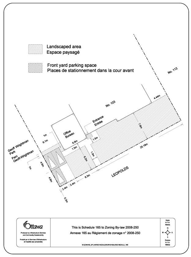
103 Leopolds Drive Ward 16 |
This property is zoned Residential First Density - R1GG[500]
S165. There is an error on the legend of Schedule 165 such that the shading
and hatching assigned to front yard parking and landscaped areas have become
reversed. Schedule 21 of the former City of Ottawa Zoning By-law 1998 shows the
reverse of the provisions of Schedule 165.
Therefore an error occurred in the transcription process between the
1998 By-law and By-law 2008-250 that needs to be corrected. |
Amend Part 17, Schedule 165, as shown in Document 4. |
|
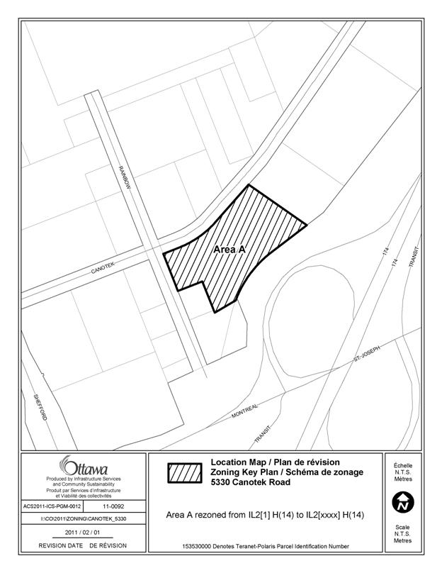
5330 Canotek Road Ward 11 |
This property is zoned Light Industrial - IL2[1] H (14). Exception [1] was incorrectly assigned to this
property on the Zoning Map. Exception
[1] permits a snow disposal facility. The Zoning Map of Gloucester By-law 333 of 1999
shows this property as zoned Business Park - Mp (E4). However, there is no Mp (E4) zone listed in
the relevant Exceptions to By-law 333 of 1999. The Zoning Map of Gloucester By-law 222 of 1984
shows 5330 Canotek Road zoned as Business Park Facility - Mp (E9). Exception (E9) states: “automotive repair garage in units No. 11 and 12 of 5330 Canotek Road.” The definition of automotive repair garage in
By-law 222 is analogous to the definition of automobile repair service
station in By-law 2008-250. As the IL2 subzone does not permit an automobile
service station, a new Exception should be created to reflect this provision
and permit an automobile service station in Units 11 and 12. |
Amend the Zoning Map of By-law 2008-250 to rezone
5330 Canotek Road from IL2[1] H (14) to IL2 [xxxx] H
(14) as shown in Document 4. Amend Section 239 of By-law 2008-250 to add new
Exception [xxxx]. Column III -
Additional Permitted Uses to read: -automobile service station And Column V - Provisions to read: -automobile service station only permitted in
units 11 and 12 of 5330 Canotek Road. |
|
22 Brisbane Road Ward 9 |
This City-owned property is known as Pineglen Park and contains a
natural area, children’s playground and tennis courts. The property was zoned Parks and Recreation Public - PRP in the former
Nepean Zoning By-law. This zone
permitted the playground, tennis courts and conservation lands. Under By-law 2008-250, the site is zoned Environmental Protection -
EP3. The EP3 subzone permits a
detached dwelling, a use that was not permitted under the former zoning
by-law and is not consistent with the Urban Natural Feature designation for
this property under the Official Plan.
The EP zone does not permit a detached dwelling. Therefore it is recommended that the Zoning Map be amended to reflect
the appropriate EP subzone. |
Amend the Zoning Map of By-law 2008-250 for 22 Brisbane Road by
rezoning the property from EP3 to EP, as shown in Document 4. |
|
820 Woodroffe Avenue Ward 7 |
This property is the site of a Salvation Army Church and is bisected
by two residential zones - R1O and R2G. The Official Plan of the former City of Ottawa, adopted in 1991,
contained policy 10.3.2 (b), which instructed City staff to create a new zone
for institutional uses and stated that the practice of permitting institutional
uses in residential zones as-of-right would cease. Consequently, existing institutional uses in residential zones were
rezoned to an institutional use. This property was constructed as a church in 1969 and was overlooked
in the rezoning process initiated by the former Official Plan. In order to remedy this, this property should be rezoned from the two
Residential uses, R1O and R2G, to Minor Institutional - I1A. |
Amend the Zoning Map of By-law 2008-250 to rezone 820 Woodroffe Avenue
as shown in Document 4. Area A is rezoned from R1O to I1A and Area B is rezoned from R2G to
I1A. |
|
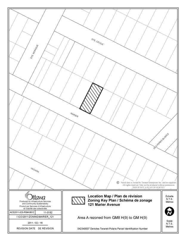
121 Marier Avenue Ward 12 |
This property is currently zoned General Mixed Use - GM8 H(9). The GM8 subzone is a site specific subzone intended to apply to lands
in the vicinity of the Vanier Parkway and Landry Street. Consequently the land uses and development standards in the subzone
are inapplicable to a property on Marier Avenue. A typographical error on the Zoning Map resulted in these lands being
zoned GM8 H(9) rather than GM H(9), which is the
appropriate zone for this property. |
Amend the Zoning Map of By-law 2008-250 to rezone 121 Marier Avenue
from GM8 H(9) to GM H(9) as shown in Document 4. |
|
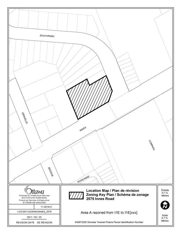
2575 Innes Road Ward 2 |
A medical facility was permitted under the former Ic - Institutional
Community zone in the Gloucester Zoning By-law 333 of 1999. An exception should have been applied to
the I1E - Minor Institutional subzone E to recognize this existing medical
facility. |
Amend the Zoning Map of By-law 2008-250 to rezone the subject lands
from I1E to I1E[xxx], as shown in Document 4. Amend Section 239 - Urban Exceptions to add a new Exception [xxx],
Column III-Additional Permitted Uses to read: -
medical facility |
|
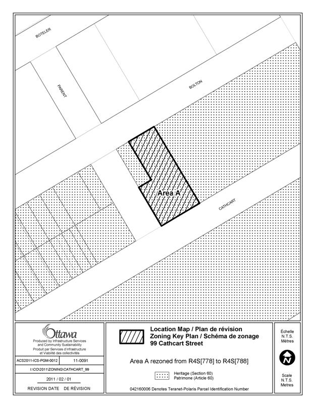
99 Cathcart Street Ward 12 |
This property, a parking lot ancillary to a hospital, is currently
zoned Residential Fourth Density - R4S[778]. Exception [778] provides additional provisions for a group home, a use
that is not in existence at this address. It is noted that the former Ottawa
Zoning By-law 93-98 permitted a parking lot and garage accessory to the
Ottawa General Hospital at this address.
In Zoning By-law 2008-250, Exception [788] permits a parking lot and
parking garage accessory to the Ottawa General Hospital. This Exception has not been applied to any
location on the Zoning Map. A typographical error occurred on the zoning map. Exception [788], the correct Exception for
this location, should have been applied on the zoning map rather than
Exception [778]. Furthermore, it would be appropriate if the Exception were amended to
refer to “ancillary” uses to the hospital as opposed to “accessory” uses. As the original Exception was written at a time when the hospital was
referred to as the Ottawa General Hospital, an amendment is needed to exception
[788] to replace this reference with “43 Bruyère Street,” the street address
of the hospital. |
Amend the Zoning Map of By-law 2008-250 to rezone 99 Cathcart Street
from R4S[778] to R4S[788] as shown in Document 4. Amend Section 239, Exception [788] by deleting the text in Column V -
Provisions, and replace with: -parking lot and parking garage ancillary to a hospital use or
ancillary to a hospital use at 43 Bruyère Street. Amend Section 239, Exception [778], Column II - Applicable Zone, by
deleting the reference to R4S[778]. |
|
70 Fieldrow Street Ward 8 |
This property is zoned Residential Second Density - R2M. It is currently the site of the Canadian
Montessori Academy. Under the former Nepean By-law 100-2000, the site was zoned
Institutional School - IS Block 5. Therefore there was a mapping error when By-law 2008-250 was
introduced. In order to remedy this, it is recommended that 70 Fieldrow Street be
rezoned to Minor Institutional - I1A. |
Amend the Zoning Map of By-law 2008-250 to rezone 70 Fieldrow Street
from R2M to I1A, as shown in Document 4. |
|
|
Text Corrections |
|
|
Section 185 - Arterial Mainstreet Zone Urban Area |
Table 185, row (f), is not clear in its reference to the exact limit
of distance from residential property lines. It is recommended that row (f) be amended as shown in Column III to
provide greater clarity in this regard. |
Amend Table 185 of
Section 185 of By-law No. 2008-250 by: deleting (f)(i) and
replacing it with "in any area up to and including 20 metres from a
property line abutting a R1, R2 or R3 residential zone" deleting (f)(ii) and
replacing it with "in any area up to and including 20 metres from a
property line abutting a R4 zone" deleting (f)(iiii) and
replacing it with "in any area over 20 metres and up to and including 30
metres from a property line abutting a R1, R2, R3 or R4 zone” |
|
General Mixed Use Subzone 8 Urban Area |
The General Mixed Use Subzone 8 zone, GM8, was implemented as a site
specific subzone. The property in question was zoned Special
Commercial Zone 1, SC-1, under the former Vanier Zoning By-law 2380. These lands were subsequently rezoned,
however the GM8 subzone provisions were not deleted from the Zoning By-law. As the GM8 provisions are site specific, it is recommended that they
be deleted from the Zoning By-law and the subzone held in reserve until such
time as a further GM subzone is needed. |
Amend the Zoning By-law by deleting the text in Section 188(8)(a) , (b) and (c). |
|
158 McArthur Avenue Ward 12 |
This property is zoned Residential Fifth Density - R5E[1098]
H(57). Exception [1098] lists a
“personal service business limited to an aesthetician” as a permitted use. The former zoning under the Vanier Zoning By-law added “aesthetician”
as a permitted use, rather than limiting the range of personal service
business uses permitted. End note 8 to the R5 Zone also applies to this property. It permits a personal service business in
the R5E zone. As the personal service
business use already includes an aesthetician, the reference to an
aesthetician in Exception [1098] is superfluous and it should be removed to
ensure clarity. |
Amend Section 239, Exception [1098], to remove the following from
Column III - Additional Land Uses Permitted: -personal service business limited to an aesthetician. |
|
506 Richardson Avenue Ward 7 |
This property is zoned Residential Fifth Density - R5B[869]
H (18). Exception [869] permits additional uses and specifies a minimum front
yard setback of 6 m and corner side yard setback of 4.5 m. Notwithstanding that this property is an interior lot, these
provisions are reflective of the former City of Ottawa By-law 1999 zoning
designation R6A and were carried over in error to By-law 2008-250. |
Amend Section 239, Exception [869], to delete the following from
Column V - Provisions: -minimum front yard setback of 6 m; -minimum corner side yard of 4.5 m |
|
1980 Ogilvie Road Ward 11 |
Column II for Exception [1333] states that the Exception applies to
zones MC [1333] F(2.0) H (30) and MC [1333] F(2.0). There are no properties shown on the Zoning Map zoned MC [1333] F(2.0) H(30). 1980 Ogilvie Road is zoned MC [1333] F(2.0)
H(48), however. Therefore Column II should be amended to reflect this. |
Amend Section 239, Exception [1333], Column II - Applicable
Zones. Delete: MC [1333] F(2.0) H(30) Replace with: MC [1333] F(2.0) H(48). |
|
455 Donald Street Ward 13 |
This property is zoned General Mixed Use- GM15[46]
F(1.0). An automobile service station has been in existence in this location
since 1959. The former Ottawa Zoning
By-law permitted an automobile service station and prohibited all other
uses. A drafting error in the
Exception [46] resulted in all uses being prohibited except for a gas
bar. |
Amend Section 239, Exception [46] , by deleting the text in Column IV-
Prohibited Uses and replacing it with the following text: -all uses except automobile service station. |
|
Central Area Ward 14 |
Section
105(2) of the Tandem Parking Provisions is unclear as it refers to parking
“in” a hotel. In order
to remedy this, it is recommended that the word “for” replace the word “in”
in the relevant sentence. |
Amend Section 105(2) of By-law 2008-250. Remove the word “in” before the words “a
hotel” and replace with the word “for,”so that the first part of the sentence
now reads: “Despite Section 100(5), attendant parking is permitted in
the Area A on Schedule 1 (Central Area) for a hotel or in a principal use or
accessory use parking garage or parking lot…” |
|
Section 191 - Mixed Use Centre Zone Urban Area |
Table 191, row (h), is not clear in its reference to the exact limit
of distance from residential property lines. It is recommended that it be amended as shown in Column III to provide
greater clarity in this regard. |
Amend Table 191 of
Section 191 of By-law No. 2008-250 by: deleting (h)(i) and
replacing it with "in any area up to and including 20 metres from a
property line abutting a R1, R2, R3 or R4 zone,” deleting (h)(ii) and
replacing it with "in any area over 20 metres and up to and including 30
metres from a property line abutting a R1, R2, R3 or R4 residential
zone" |
|
Section 191 - Mixed Use Centre Zone Urban Area |
Sub paragraph 192(9)(d) of the Mixed Use
Centre Zone is currently grammatically incorrect and unclear. This provision is from the former Kanata Zoning By-law 78-96, subsection
8.2(i)(vi), which reads: The Gross Leasable Floor Area (GFLA) of any individual non residential
use, other than a Department Store or Cinema/Theatre, shall not exceed a
maximum of 5,000 square metres. Therefore the grammatically unclear sub paragraph should be amended
accordingly. |
Amend sub paragraph 192(9)(d) of the Zoning By-law so that it reads: “No individual use may exceed a total gross leasable floor area of
5,000 square metres.” |
DOCUMENT 2
LIST OF ANOMALIES AND MODIFICATIONS
TO ZONING
BY-LAW 2008-250 FOR CONSIDERATION BY
THE AGRICULTURAL
AND RURAL AFFAIRS COMMITTEE
|
I Item |
II Object of
Amendment |
III Proposed Amendment |
|
|
Map Corrections |
|
|
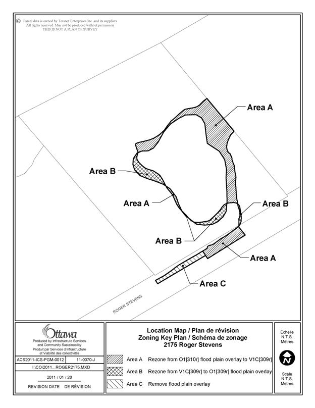
Parts
of 2175 Roger Stevens Drive Ward
21 |
This
property is currently zoned both Village First Density Residential - V1C[309r] and Parks and Open Space - O1[310r]. In addition, there is a Flood Plain Hazard
Overlay mirroring the O1 Zone. Exception
[309r] permits an agricultural use and a park use and Exception [310r]
permits an agricultural use. The
Flood Plain Hazard Overlay shown on the Zoning Map mirrors that shown by the -
Valley Conservation Authority (RCVA). The
RCVA recently changed the Flood Plain Hazard Overlay boundary as it relates
to 2175 Roger Stevens Drive. Therefore
it is appropriate that the City’s Zoning Map be changed accordingly. Furthermore,
because the O1 zone mirrors the Flood Plain Hazard Overlay in village
designations, on residential lots, the appropriate area no longer covered by
the Overlay will need to be rezoned V1C[309r] to place it in accordance with
the zoning of the balance of the lot. |
Amend
the Zoning Map of By-law 2008-250 to show the new boundary of the Flood Plain
Hazard Overlay for 2175 Roger Stevens Drive as shown in Document 4. Rezone
that part of 2175 Roger Stevens Drive no longer within the Flood Plain Hazard
Overlay from O1[310r] to V1C[309r], as shown in
Document 4. |
|
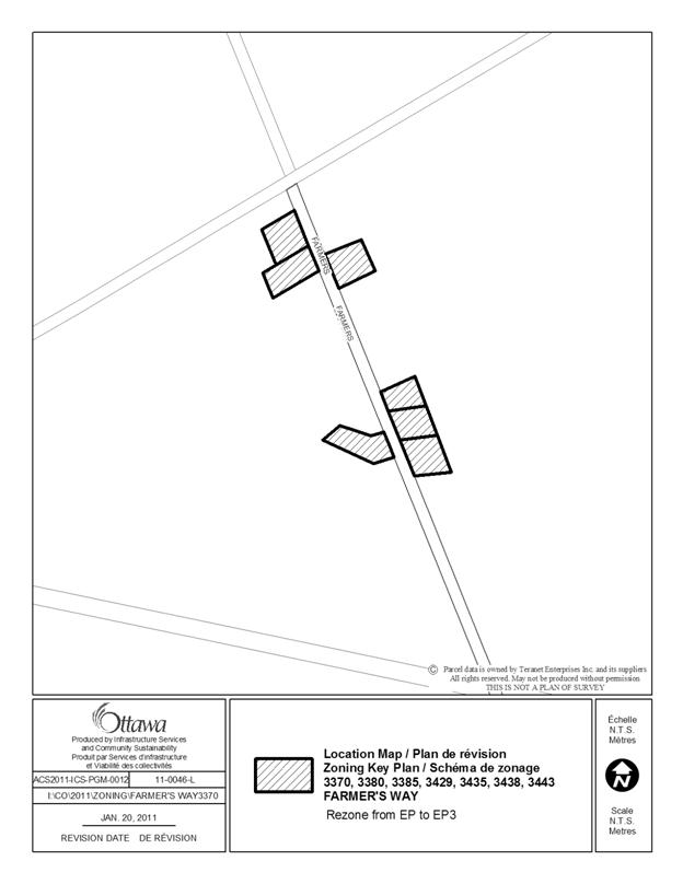
3370,
3380, 3385, 3429, 3435, 3438, 3443 Farmer’s Way Ward
19 |
These
properties are zoned Environmental Protection Zone -EP, in By-law 2008-250. Under
the former Gloucester By-law, they were zoned Estate Residential - Re1 The EP
zone does not permit a detached dwelling and therefore is not representative
of the prior Estate Residential zone. All of
these properties have detached dwellings that predate the zone change. As the Official Plan policy 3.2.2.3 permits
a detached dwelling in the applicable Land Use Category, Natural Environment
Area, and the previous zoning was for a residential use, Estate Residential,
the zoning should be changed from EP to EP3 to permit a detached dwelling. |
Amend
the Zoning Map of By-law 2008-250 to rezone 3370, 3380, 3385, 3429, 3435,
3438, 3443 Farmer’s Way from EP to EP3, as shown in Document 4. |
|
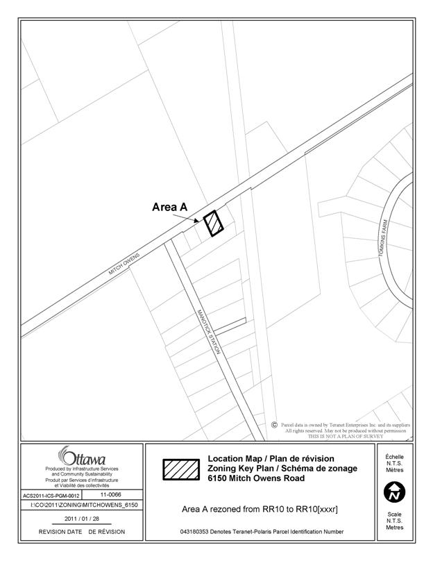
6150
Mitch Owens Road Ward
20 |
This
property is zoned Rural Residential - RR10. Under
the previous Osgoode By-laws 16-1971 and 2003-230 the property was zoned
Village Community - V. This was a
mixed use zone that permitted a variety of residential and non residential
uses, including a hair salon. In
order to recognize a use formerly permitted under By-law 2003-230, amendments
are proposed to permit a hair salon, run as a home-based business, having
three coiffeur chairs and two off-site employees. Therefore
a new Exception should be created to permit a hair salon, run has a home
based business, at that location. The
hair salon would have permission for 3 coiffeur chairs, 2 on-site,
non-resident employees and the ability to serve no more than 3 customers at a
time. |
Amend
the Zoning Map of By-law 2008-250 to rezone 6150 Mitch Owens Road from RR10
to RR10[xxxr], as shown in Document 4. Amend
Section 240 of the By-law by adding Exception [xxxr]. Column V - Provisions to read: -Despite any provisions to the contrary in Section 127, the following apply to a hair salon operated as a home based business: - limited to a maximum of three coiffeur chairs. - 2 on-site, non-resident employees are permitted per principal dwelling unit. - three clients or customers may
be attended or served on-site. |
|
Canon
Smith Drive, Timber Lane and Part of Moorhead Drive Ward 5 |
These
properties are zoned Rural Residential - RR5[19r]. These
properties are affected by the provisions of both By-laws 2009-347 and
2010-125. By-law
2009-347 was appealed. The provisions
of By-law 2010-125 are reflected in Exception [19r]. Exception [19r] carries forward provisions
from the former West Carleton Zoning By-law to permit lots on private Roads. By-law
2009-347 is no longer under appeal.
Its provisions are reflected in Exception [343r]. However,
the provisions of [343r], regarding watercourse setbacks, have not yet been
applied to the properties in question, the only geographic area where the
provisions of both By-laws overlap. Therefore
a new Exception [xxxr] needs to be created for this geographic overlap area to reflect the
provisions of both By-laws. |
Amend
the Zoning Map of By-law 2008-250 to
rezone the properties shown in Document 4 as follows: Area A rezoned from RR5[19r] to RR5[xxxr]; Area B rezoned from RR14[19r] to RR14[xxxr]; Area C rezoned from RR15[19r] to RR15[xxxr] Amend
Section 240 by adding
Exception [xxxr]. Column
V - Provisions to read: - despite Section 59 -
Frontage on a Public Street, development of the subject land is permitted.
- additions and accessory structures, maximum 24
square metres in floor area as measured from the outside walls, are permitted
within the 30 metre setback from watercourses and waterbodies as long as the
addition or accessory structure is no closer than the principal building to
the water.
|
|
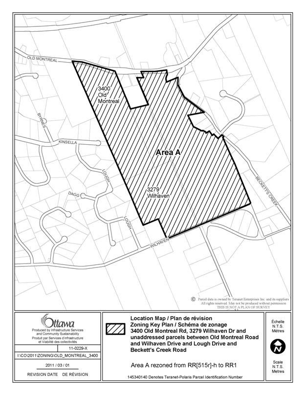
3400
Old Montreal Road, 3279 Wilhaven Drive and unaddressed parcels between Old
Montreal Road and Wilhaven Drive and Lough Drive and Beckett’s Creek Road Ward 19 |
The
subject lands are zoned RR[515r]-h. The exception [515r] and holding symbol
were applied in error as the former Cumberland Zoning By-law 64-82 did not
apply a holding symbol or exception to these lands. Further, the RR1 subzone should have been applied
to these lands as this subzone best reflects the lot area and lot width
requirements of the former Cumberland
ER - Estate Residential zone. |
Amend
the Zoning Map of By-law 2008-250 to rezone the subject lands from RR[515r]-h to RR1, as shown in Document 4. |
|
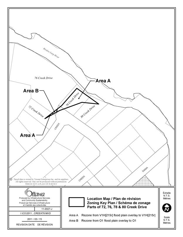
Parts
of 72, 76, 78, 80 Creek Drive Ward 5 |
The
Mississippi Valley Conservation Authority has provided updated mapping
information regarding the location of the flood plain, and accordingly, the
location of the flood plain overlay on the zoning map requires
amendment. |
Amend
the Zoning Map of By-law 2008-250 to rezone
parts of the subject lands from V1H[215r] - Flood plain overlay to V1H[215r],
and from O1- Flood plain overlay to
O1, as shown in Document 4. |
|
|
Text Corrections |
|
|
6630
Third Line Road South Ward
21 |
This
property was zoned A2 - General Rural under the provisions of the former -
Zoning By-law 2004-428. The A2
zone permitted a variety of uses, among these being a single family dwelling
and agricultural uses, including equestrian-related activities. Under
By-law 2008-250 this property is zoned V1C[309r] and
O1[310r]. These are Village
Residential First Density and Open Space, the latter reflecting the Flood
Plain Hazard Overlay that partially covers the site. Exceptions
[309r] and [310r] permit an agricultural use, however the existing equestrian
establishment was not recognized in either Exception. |
Amend
Section 240, Exception [309r], to add the following permitted use to Column
III - Additional Land Uses Permitted: -Equestrian
Establishment. Add in
Column V - Provisions: -The
provisions of Table 211, Column II apply. -Minimum
lot area for agricultural use or equestrian establishment is 15 hectares. |
|
3850 Milton Road Ward 19 |
Column II for Exception [244r] states that the
Exception applies to zone AG2[244r]. There is no property zoned AG2[244r]
shown on the Zoning Maps. 3850 Milton
Road is zoned AG[244r]. As such, reference to the AG2[244r]
exception zone should be deleted from Column II. |
Amend
Section 240 of the Zoning By-law, Exception [244r], by deleting AG2[244r] from Column II - Applicable Zone. Place AG[244r] in Column II - Applicable Zone. |
|
2980
Conley Road Ward
21 |
This
property is zoned RC4[460r]. Exception [460r] prohibits all other uses
save an amusement park, limited to a dirt race track. Under
the former Goulbourn Zoning By-law 40-99, this property was designated OS -
Open Space. This provision permitted
an “outdoor recreational establishment,” a “race track,” and a “tourist camp.” Notwithstanding
that Exception [460r] prohibits all other uses except a dirt race track, a “tourist camp” was previously permitted at this
location under the OS provisions. As a
“tourist camp” is analogous to a campground, and this is a permitted use in
the RC4 zone and this site was previously used as a “tourist camp,” a
campground should be added to the list of permitted uses under Exception
[460r]. It
should be further noted in Exception [460r] that the campground use be
seasonal so as to fully reflect the definition of “tourist camp” in By-law
40-99. |
Amend
Section 240 of the Zoning By-law, Exception [460r], by adding the the
following to Column IV - Land Uses Prohibited: (all
uses except for) -a
campground Add to
Column V - Provisions: -a
campground is a seasonal use only. |
|
2405
March Road Ward 5 |
This
property is zoned Rural Commercial - RC3[213r]. Previously,
the property was zoned Rural Commercial Exception Zone 33 (CR-33) in the
former West Carleton Zoning By-law 266 of 1981. The
CR-33 zone contained a parking provision for 5 spaces that was not carried
over into By-law 2008-250.
Consequently it is recommended that Exception [213r] be amended to
reflect this provision. |
Amend
Section 240 of By-law 2008-250, Exception [213r], by adding the following to
Column V - Provisions: -minimum
of 5 parking spaces required. |
DOCUMENT 3
LIST OF ANOMALIES AND MODIFICATIONS TO ZONING BY-LAW
2008-250 FOR CONSIDERATION BY PLANNING COMMITTEE
AND AGRICULTURAL AND RURAL AFFAIRS COMMITTEE
|
I Item |
II Objective of
Amendments |
III Proposed
Amendments |
|
Section
112 - Provisions for Drive-Through Operations City-wide |
Section
112 contains an error at subsection (4), which reads: “Despite
subsection (4), where a queuing line...”
The subsection refers to itself in error; it should refer to
subsection ‘(3)’. |
Amend
Section 112(4) to remove the reference to ‘(4)’ and replace with ‘(3)’. |
|
Section
111 - Bicycle Parking Space Rates and Provisions City-wide |
Section
111(7) states: “A maximum of 50% of the required bicycle parking spaces or 15 spaces,
whichever is greater, may be located in a landscaped area except for the
landscaped area required under subsection (5).” Section 111(5) states: “Deleted as per (OMB File #PLO80959 issued November 5, 2009)”. Consequently subsection 111(7) refers to 111(5) in error and needs to
be amended accordingly. |
Amend
Section 111(7). Remove “...except
for the landscaped area required under subsection (5).” |
|
Section
101 - Minimum Parking Space Rates City-wide |
Row
(cl) of Table 101 refers to “Restaurant - Fast Food (drive-in). The term “drive-in” is not currently used
in By-law 2008-250. |
Amend
Table 101. Delete the term “drive-in”
from Row (cl). |
DOCUMENT 4
LIST OF SITE-SPECIFIC LOCATION MAPS
|
Location Maps (attached) |
|
103 Leopolds Drive |
|
5330 Canotek Road |
|
22 Brisbane Road |
|
820 Woodroffe Avenue |
|
121 Marier Avenue |
|
2575
Innes Road |
|
99 Cathcart Street |
|
70 Fieldrow Street |
|
2175 Roger Stevens Road |
|
3370, 3380, 3385,
3429,3435, 3438, 3443 Farmer’s Way |
|
6150 Mitch Owens Road |
|
Parts of Canon Smith Drive, Timber Lane and Part of Moorhead Drive |
|
3400
Old Montreal Road, 3279 Wilhaven Drive and unaddressed parcels between Old
Montreal Road and Wilhaven Drive and Lough Drive and Beckett’s Creek Road |
|
Parts
of 72, 76, 78, 80 Creek Drive |
Comprehensive
zoning by-law 2008-250:
anomalies and minor corrections - first quarter 2011
rÈglement gÉnÉral de zonage 2008-250 : anomalies et corrections mineures -
premier trimestre de 2011
ACS2011-ICS-PGM-0012 CITY WIDE / À
L’ÉCHELLE DE LA VILLE
Mr. Euan Wood, Planner, Land Use and Natural Systems, Policy Development
and Urban Design, Planning and Growth Management (PGM), Infrastructure Services
and Community Sustainability (ISCS), began by introducing Ms. Carol Ruddy,
Planner, Land Use and Natural Systems, PGM, ISCS. Mr. Wood then spoke to a PowerPoint slide
presentation which served to provide the Committee with a brief overview of the
staff report. A copy of this
presentation is held on file with the City Clerk.
In response to questions from the Chair as to how much longer such
anomaly reports would require Committee’s review, Mr. John Moser, General
Manager, PGM, ISCS, reported that although such reports are currently prepared
on a quarterly basis, it was hoped
that over time, they would proceed yearly,
as staff finish dealing with remaining anomalous situations.
Mr. Doug Argue, the property owner of 2980 Conley
Road, spoke in support of the reintroduction of camping as a permitted use for
his property under the By-Law. He also
outlined his concerns regarding the removal of the previously-allowable uses,
which had included amusement park, camping, golf course, etc., but which had
been removed in 2008, leaving motocross
track as the only permitted use. Mr.
Argue also noted there were also mapping discrepancies associated with his
62-acre property, which did not seem to encompass the original subject area as
delineated in the early 1970’s, and he questioned whether, as a result, there
were two zonings on the property.
Ms. Ruddy explained that the current
zoning reflected, as accurately as possible, the former zoning boundaries of
the former Goulbourn Zoning By-Law, given that many of the older maps had been
hand-drawn, which had presented difficulties when switching to an electronic
mapping database. With regard to the
range of permitted uses, Ms. Ruddy explained that Official Plan (OP) policies
for the General Rural Area provide direction that villages should be the focus
of development, and that in general, the range of permitted commercial uses in
the General Rural Area is quite restricted.
She added that in drafting the new Zoning By-Law, the approach had been
to recognize all existing commercial uses, acknowledging that some had been
lost in the process of developing new Rural Commercial zones, as it would not
be in order to have a wide range of commercial uses dispersed throughout the
General Rural Area.
Mr. Argue commented that many of the
previously allowable uses were not of the kind that most residents would want in
a town environment, i.e.; amusement park or
racetrack, which were previously listed as separate uses under the old By-Law, and
with the new By-Law listing the racetrack as
an amusement park use. Ms. Ruddy
acknowledged that the current zoning is restrictive, permitting only an
amusement park limited to a racetrack in this location. She said the recommended amendment to the
report would add the use of campground, which was a legally-established use at
the time CZBL 2008-250 came into effect, but of which staff had been unaware at
the time.
Chair Thompson felt it would be prudent to defer this section of the
report for further review and discussion with the Ward Councillor (Councillor
Moffatt), to return for the Committee’s consideration at its next meeting,
rather than try to resolve matters in haste.
Councillor Moffatt concurred, acknowledging that in addition to the
concerns raised by the property owner, neighbouring property owners also had
concerns of their own.
In response to questions from the property owner as to what would happen
in the meantime regarding his campground use, Ms. Ruddy confirmed that Mr.
Argue did have a legal, non-conforming right to the existing campground use,
established under the former Goulbourn By-Law, which would continue as a
permitted use. With the concurrence of
the Ward Councillor, the property owner and staff, it was agreed that this
matter would be deferred, for the Committee’s consideration, to its next
meeting.
Dr. Ranjit Perera referenced the report with
respect to his own property holdings in Cumberland, for which he had undertaken
a subdivision application, and he questioned whether neighbouring property
owners had also been informed of the proposed changes in zoning. Assured by staff that they had been contacted,
Mr. Perera then referred to a holding symbol designation on part of his property for which he had been in
discussions with staff regarding the creation of a multi-cultural,
multi-generational, and multi-faith sanctuary and sculpture park. He asked whether converting the designation
to RR1 from the holding designation
would permit additional uses. Ms. Ruddy
explained that Exception 515r does
not add uses, but applies a condition stipulating that development may only
occur on subject lands upon the approval of a subdivision application or
consent application. She further added
that the holding symbol and related
conditions were never in effect under the former Zoning By-Law, but were
applied in error, and that this amendment would correct the zoning, and return
it to what it had been previously (and to what it should have been when CZBL
2008-250 was adopted in June of 2008).
Moved by Councillor S. Moffatt:
That the Agriculture and Rural Affairs Committee recommend Council
approve the amendments recommended in Column III of Documents 2 and 3 to
correct anomalies in Zoning By-law 2008-250, as further amended by the
following:
Deleting the text in Document 2 regarding the property located at 2980
Conley Road, to allow for a deferral of consideration of this property to a
future meeting of the Agriculture and Rural Affairs Committee.
CARRIED
as amended
Comprehensive zoning by-law 2008-250:
anomalies and
minor corrections - FIRST QUARTER 2011 - 2980
CONLEY ROAD
rÈglement gÉnÉral de zonage 2008-250 : anomalies et
corrections mineures - premier
trimestre de 2011 -
2980, Chemin Conley
ACS2011-ICS-PGM-0012 RIDEAU-Goulbourn (21)
REPORT RECOMMENDATIONS:
That the Agriculture and Rural Affairs Committee recommend Council amend
Section 240 of Comprehensive Zoning By-law 2008-250, Exception [460r], by
adding the following to Column IV - Land Uses Prohibited:
(all uses except for)
- a campground
And add to Column V - Provisions:
- a campground is a seasonal use only.
Consideration
of the portion of this report dealing with the property located at 2980
Conley Road was deferred from the Agriculture and Rural Affairs Committee
meeting of 7 April 2011.
Councillor
Moffatt said that he had spoken with the owner and planner involved, and that
although work on zoning would continue, the Committee could proceed to accept
the recommendation as presented.
The report recommendations were then put to
Committee and CARRIED, as presented.