|
2. WELLINGTON STREET WEST COMMUNITY
DESIGN PLAN, OFFICIAL PLAN AMENDMENT, ZONING BY-LAW AMENDMENT
PLAN DE CONCEPTION COMMUNAUTAIRE DE LA RUE WELLINGTON OUEST,
MODIFICATION AU PLAN OFFICIEL, MODIFICATION AU RÈGLEMENT DE ZONAGE
|
Committee recommendationS
That Council:
1.
a) Approve
the Wellington Street West Community Design Plan (distributed separately and on
file with the City Clerk and shown as Document 2) as Council's direction on the
future development of the area;
b) Approve
and adopt an amendment to the Official Plan of the City of Ottawa, Volume 2A,
to incorporate Part B of this amendment as a Secondary Plan, as detailed in
Document 3;
c) Approve an
amendment to Zoning By-law 2008-250 of the City of Ottawa as detailed by the
table and locations maps in Document 4.
2. Direct the Planning and
Growth Management Department, Heritage Services Unit to:
a)
Submit the list of buildings to be added to the
Heritage Register, as noted in Appendix 1 of the Wellington Street West
Community Design Plan, for review and approval to OBHAC; and to present that
approved list to City Council for adoption;
b) Conduct
a heritage assessment of 1137 Wellington Street (the present Senior Support Services Centre).
3. Direct the
Real Estate Partnership and Development Office to undertake an asset
rationalization process to determine the long-term viability of
1137 Wellington Street (the present Senior Support Services Centre).
RecommandationS
du comité
Que le Conseil :
1. a) approuve le plan de conception communautaire
de la rue Wellington Ouest (distribué séparément et porté au dossier du greffier municipal, correspondant
au document 2) suivant les directives du Conseil sur le développement de
ce secteur dans les années à venir;
b) approuve et d’adopter une
modification au Plan officiel de la Ville d’Ottawa, Volume 2A, qui
consiste à intégrer la partie B de cette modification comme plan
secondaire, tel que précisé dans le document 3;
c) approuve une modification au
Règlement de zonage 2008-250 de la Ville d’Ottawa comme précisé dans le tableau
et les plans de révision du document 4.
2. demande au Service de l’urbanisme et de la
gestion de la croissance, Services du patrimoine :
a) de présenter la liste des immeubles à ajouter au registre des biens à
valeur ou à caractère patrimonial, comme indiqué à l’annexe 1 du PCC de la
rue Wellington Ouest, au CCPBO aux fins d’examen et d’approbation; et de
soumettre la liste approuvée au Conseil municipal pour que ce dernier l’adopte;
b)
d’effectuer une évaluation de la
valeur patrimoniale du 1137, rue Wellington (l’actuel Centre de soutien
aux aînés).
3. demande au Bureau des partenariats et du
développement en immobilier de préparer un rapport sur l’état de l’immeuble
afin de déterminer la viabilité à long terme du 1137, rue Wellington (l’actuel Centre de soutien aux aînés).
Documentation
1.
Deputy
City Manager's report, Infrastructure
Services and Community Sustainability, dated 14 April 2011 (ACS2011-ICS-PGM-0086).
2. Extract of Planning
Committee Minutes of 26 April 2011.
Report to/Rapport au :
Planning Committee
Comité de l'urbanisme
and Council / et au Conseil
14 April 2011 / le 14 avril 2011
Submitted by/Soumis par : Nancy
Schepers, Deputy City Manager
Directrice municipale
adjointe, Infrastructure Services and Community Sustainability, Services d'infrastructure et Viabilité des collectivités
Contact Person/Personne-ressource : Richard Kilstrom,
Manager/Gestionnaire,
Policy Development and Urban
Design/Élaboration de la politique et
conception urbaine
Planning and Growth Management/Urbanisme et Gestion de
la croissance
(613) 580-2424, 22379 Richard.Kilstrom@ottawa.ca
|
|
Ref N°: ACS2011-ICS-PGM-0086
|
|
SUBJECT:
|
Wellington Street WEst community
Design Plan (File no. D04-01-06-WCDP),
OFFICIAL PLAN AMENDMENT (FILE NO.
d01-01-10-0009, zoning by-law amendment (file no. d02-02-09-0006)
|
|
|
|
|
OBJET:
|
PLAN
DE CONCEPTION COMMUNAUTAIRE DE LA RUE WELLINGTON OUEST, MODIFICATION AU PLAN
OFFICIEL, MODIFICATION AU RÈGLEMENT DE ZONAGE
|
REPORT
RECOMMENDATIONS
1. That Planning Committee recommend Council:
a) Approve the
Wellington Street West Community Design Plan (distributed separately and on
file with the City Clerk and shown as Document 2) as Council's direction on the
future development of the area;
b) Approve and adopt an
amendment to the Official Plan of the City of Ottawa, Volume 2A, to incorporate
Part B of this amendment as a Secondary Plan, as detailed in Document 3;
c) Approve an amendment
to Zoning By-law 2008-250 of the City of Ottawa as detailed by the table and
locations maps in Document 4.
2. That Planning Committee direct the
Planning and Growth Management Department, Heritage Services Unit to:
a)
Submit the
list of buildings to be added to the Heritage Register, as noted in Appendix 1
of the Wellington Street West Community Design Plan, for review and approval to
OBHAC; and to present that approved list to City Council for adoption;
b)
Conduct a
heritage assessment of 1137 Wellington Street (the present Senior Support
Services Centre).
3.
That Planning Committee direct the
Real Estate Partnership and Development Office to undertake an asset
rationalization process to determine the long-term viability of 1137 Wellington
Street (the present Senior Support Services Centre).
RECOMMANDATIONS DU RAPPORT
1. Que
le Comité de l’urbanisme recommande au Conseil :
a) d’approuver le plan de conception
communautaire de la rue Wellington Ouest (distribué séparément et porté au
dossier du greffier municipal, correspondant au document 2) suivant les
directives du Conseil sur le développement de ce secteur dans les années à
venir;
b) d’approuver et d’adopter une
modification au Plan officiel de la Ville d’Ottawa, Volume 2A, qui
consiste à intégrer la partie B de cette modification comme plan
secondaire, tel que précisé dans le document 3;
c) d’approuver une modification au
Règlement de zonage 2008-250 de la Ville d’Ottawa comme précisé dans le tableau
et les plans de révision du document 4.
2. Que
le Comité de l’urbanisme demande au Service de l’urbanisme et de la gestion de
la croissance, Services du patrimoine :
c)
de présenter la liste des immeubles
à ajouter au registre des biens à valeur ou à caractère patrimonial, comme
indiqué à l’annexe 1 du PCC de la rue Wellington Ouest, au CCPBO aux fins
d’examen et d’approbation; et de soumettre la liste approuvée au Conseil
municipal pour que ce dernier l’adopte;
d)
d’effectuer une évaluation de la
valeur patrimoniale du 1137, rue Wellington (l’actuel Centre de soutien
aux aînés).
3. Que
le Comité de l’urbanisme demande au Bureau des partenariats et du développement
en immobilier de préparer un rapport sur l’état de l’immeuble afin de
déterminer la viabilité à long terme du 1137, rue Wellington (l’actuel Centre de soutien aux aînés).
EXECUTIVE SUMMARY
Assumptions
and Analysis:
The Wellington Street West Community Design Plan (CDP) is a broad
and integrated 20-year vision for the mainstreet spanning the Hintonburg and
West Wellington Village communities, between Island Park Drive and Breezehill
Avenue. It provides planning and design
policy for both the development of private lands and the undertaking of public
works.
The Wellington Street West CDP is
unique amongst CDPs to date, as it was undertaken at the same time as two other
City of Ottawa projects: the
Neighbourhood Planning Initiative (NPI) and the Wellington Street Road
Reconstruction. The City undertook extensive
public consultation for these three projects from January 2007 to September of
2010 to ensure collaborative and comprehensive planning for the community. This process resulted in three joint NPI public
open houses, one CDP-dedicated final public open house, 14 CDP-dedicated
meetings with community representatives (the Continuity Task Force (CTF)), 35 joint-NPI meetings and sites visits with
CTF members, and on-line surveys.
The CDP process resulted in a vision and a framework with seven
goals for the Wellington mainstreet area.
The vision for the community is one of embracing change, creating people
spaces, respecting the traditional urban fabric, and ensuring the continued
development of an accessible, pedestrian and transit-friendly community. This framework, which provides the foundation
of the CDP’s planning and design policy directions for urban planning and
design, focuses in two areas:
1.
General mainstreet scale and character design policies
shared throughout the study area; and,
2.
Area-specific design policies that require a more
“localized” approach given a unique circumstance that could not be addressed by
the guidance of the general mainstreet design policies. For a plan locating
these area policies, see Document 3, Schedule B, “Specific Policy Areas”.
The CDP is the culmination of an extensive
consultation process that includes input from a variety of community stakeholders
and sets the direction to achieve the built form and public space envisaged for
Wellington Street West mainstreet. Key
to implementing this community’s vision will be the adoption of the CDP
document, a Secondary Plan, Zoning By-law amendments, heritage protection
measures, and three follow-up studies.
These design policies are intended to supplement
the relevant Official Plan policies,
to which they conform. Similarly, the Urban
Design Guidelines for the Development along Traditional Mainstreets remains
an essential tool for development guidance within this CDP area. Where there is
an apparent discrepancy between the CDP and the City’s Traditional Mainstreet
guidelines, the CDP design policy will have higher status given its intimacy
with the subject matter.
Legal/Risk
Management Implications:
There are no legal/risk
management implications associated with this report.
Technical Implications:
N/A
Financial Implications:
There are no direct financial
implications associated with this report.
The Wellington Street West CDP recommends two follow-up studies to
implement the Plan (outlined in Recommendations 2b and 3. It is expected that these will be conducted
through existing staff resources when these studies come forward in future work
programs.
Public
Consultation/Input:
The Wellington Street West CDP
had an extensive public consultation program in collaboration with the
Neighbourhood Planning Initiative (NPI), including: four public open houses, 14 Continuity
Task Force (CTF) meetings dedicated for CDP issues exclusively (35 other
joint-meetings were held with the NPI and Wellington Street Road Reconstruction
project), and three site visits with the CTF.
RÉSUMÉ
Hypothèses et analyse
Le plan de conception
communautaire (PCC) de la rue Wellington Ouest propose une vision globale et
intégrée, sur une période de 20 ans, de l’artère principale qui traverse les quartiers d’Hintonburg et de
Wellington Ouest, entre la route Island Park et l’avenue Breezehill. Dans ce
plan sont décrites les politiques d’aménagement et de conception pour le
développement des terrains privés et de la réalisation de travaux publics.
De tous les PCC
entrepris à ce jour, celui de la rue Wellington Ouest est unique puisqu’il a été mis en œuvre en
même temps que deux autres projets de la Ville : l’Initiative de
planification du voisinage (IPV) et la réfection de la rue Wellington. De
janvier 2007 à septembre 2010, la Ville a mené une importante
consultation publique sur ces trois projets afin de garantir un processus
global et collaboratif de planification pour les membres de la collectivité. Ce
processus s’est traduit par trois journées portes ouvertes conjointes sur
l’IPV, une dernière journée portes ouvertes portant uniquement sur le PCC,
14 réunions sur le PCC auxquelles ont participé des représentants de la
collectivité (le groupe de travail [GT] chargé de la continuité), 35 réunions
conjointes sur l’IPV et des visites des lieux avec des membres du GT chargé de
la continuité, sans oublier les sondages réalisés en ligne.
Le processus lié au
PCC a débouché sur une vision et un cadre de travail prévoyant sept objectifs
pour le secteur de l’artère principale qu’est la rue Wellington. Pour la collectivité, cette vision
est axée sur le changement, l’aménagement d’espaces pour les citoyens, le
respect du tissu urbain traditionnel et garantit le développement durable d’une
collectivité qui mise sur un réseau de voies accessibles aux piétons et au transport
en commun. Ce cadre de travail, sur lequel reposent les orientations des
politiques des PCC en matière d’aménagement et de conception urbaines, met
l’accent sur deux points :
1. Politiques générales pour le style
et la conception de la rue principale, qui seront communs à tout le secteur à
l’étude;
2. Politiques de conception propres à
un secteur, qui exigent une approche plus « locale » compte tenu des
circonstances particulières auxquelles il n’est pas possible d’adapter
efficacement les politiques générales de conception de la rue principale. Pour
consulter le plan détaillé sur ces politiques relatives à un secteur voir le
document 3, annexe B (politiques propres à un secteur).
Le PCC est la somme d’un processus de
consultation d’envergure au cours duquel les opinions et commentaires de
différents intervenants communautaires ont été recueillis. Il permet d’établir
les orientations relativement à la forme bâtie et aux espaces publics qui sont
prévus pour la rue Wellington Ouest. Dans la mise en œuvre de cette vision
commune, le facteur décisif sera l’adoption du PCC, d’un plan secondaire, des
modifications au Règlement de zonage, des mesures de protection du patrimoine
et des recommandations de trois études de suivi.
Ces politiques de conception visent à compléter les politiques pertinentes du Plan officiel
de la Ville d’Ottawa, auxquelles elles doivent se conformer. Dans le même ordre
d’idées, les lignes directrices sur
l’aménagement urbain de la Ville d’Ottawa pour le développement des rues principales traditionnelles demeurent
un outil essentiel pour encadrer le développement dans ce secteur visé par un
PCC. S’il semble y avoir des contradictions entre le PCC et les lignes
directrices de la Ville concernant les rues principales traditionnelles, la politique
de conception du PCC prévaudra étant donné qu’elle est très étroitement liée à
l’objet en question.
Incidences juridiques ou concernant
la gestion des risques
Sur le plan juridique ou de la gestion des
risques, rien n’empêche la mise en œuvre du présent rapport.
Incidences techniques
S.O.
Répercussions financières
Le présent
rapport n’aura aucune incidence financière directe. Dans le PCC de la rue Wellington Ouest, il
est recommandé de réaliser deux études de suivi en vue de la mise en œuvre du
plan (selon les recommandations 2b et 3). C’est le personnel actuel qui
est censé s’en charger lorsque ces études seront mises de l’avant dans le cadre
de futurs programmes des projets.
Consultation publique/Commentaires
Le PCC de la rue Wellington Ouest découle d’un
important projet de consultations publiques, mené de concert avec l’Initiative
de planification du voisinage (IPV), et qui comprenait : quatre journées
portes ouvertes, 14 réunions du GT chargé de la continuité qui visaient
expressément à traiter des questions ayant trait au PCC (35 réunions communes ont eu lieu sur l’IPV et le
projet de réfection de la rue Wellington), et enfin, la visite de trois sites par le GT chargé de
la continuité.
BACKGROUND
A Community Design Plan was
initiated in May 2006 along the Wellington Street West corridor to: 1) Address future growth management in areas
designated Traditional Mainstreet and Mixed Use Centre, as per the Official
Plan; 2) Collaborate with the pilot Neighbourhood Planning Initiative (NPI);
and 3) Collaborate with the public works Wellington Street Reconstruction
project, each having similar timeframes.
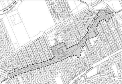
The CDP study area boundary is shown
on the Location Map (Document 1). The
CDP recommendations focus on the Official Plan designated “Traditional
Mainstreet” area. These are generally properties
that front onto Wellington Street between Island Park Drive and Breezehill
Avenue. The study area also includes a
portion of the “Mixed-Use Centre” designated area bounded by Holland and Parkdale
Avenues and Wellington and Spencer Streets.
Both the Hintonburg and West Wellington Village neighbourhoods had a
formative role in the development of the CDP based on their proximity to the
study area.
The goal of the study was to
develop a broad and integrated 20-year vision for the Wellington Street West
corridor area to guide both private development and the undertaking of public
works. Following preliminary meetings to
initiate the working relationships between the other two NPI projects (i.e.
Neighbourhood Plan and the Wellington Street Reconstruction project) the
project was publicly launched in January 2007 and broad public consultation was
completed by September 2010.
DISCUSSION
The following discussion divides
the recommendations into two groups:
1)
Recommendations 1a, 1b, 1c, and 2a are actions to be
taken immediately to implement the CDP.
These include the adoption of the CDP, the Secondary Plan, the Zoning
By-law amendments, a Heritage designation at 7 Hinton Avenue, and the list of
properties to be added to the Heritage Register;
2)
Recommendations 2b and 3 are actions needing further
study as a result of the CDP. These
include studies to be undertaken by various departments regarding the existing
and future condition and role of the building at 1137 Wellington Street and exploring
the options for McCormick Park, including potentially more parkland.
RECOMMENDATION 1a) Wellington Street West
Community Design Plan
Recommendation 1a) is to approve
the CDP as Council's direction for the future development of the Wellington
Street West area. It provides the basis
for the Official Plan Amendment, detailed in Document 3, to add the Wellington
Street West Secondary Plan to the Official Plan, Volume 2A, and for the Zoning
By-law amendments detailed in Document 4 to implement the CDP recommendations
related to built form and land use.
Design Framework and Goals
The CDP provides a design
framework for the design and land use vision of all new and restored, public
and private built forms and spaces along Wellington mainstreet over the next 20
years.
This design framework includes seven
goals for the Wellington mainstreet area:
a)
Uphold
and enhance the existing broad mix of uses
b)
Establish
a clear network of people spaces
c)
Strengthen
the traditional urban fabric, built form and spaces through respect and
innovation
d)
Capture
the opportunities of key mainstreet nodes and gateways
e)
Protect,
create and encourage views and vistas
f)
Link
the varied character areas together as a unified corridor
g)
Promote
a pedestrian and transit-friendly environment
This framework informed the
development of the guiding principles and objectives that provide the
foundation for (1) the general planning and design policies that apply to the
overall Wellington Street corridor study area; and (2) the policies that apply
to four specific areas that define important character areas of the mainstreet
and exhibit opportunities for future physical development of the
mainstreet.
A principal objective of all CDPs
is to implement the City’s growth management strategy. The Wellington Street West CDP estimates that
about 950 dwelling units will be developed within the study area from 2006 to
2031, or about 38 dwelling units per year. This achieves the City's Residential
Land Strategy for minimum intensification targets for the area.
Given that the CDP maintains the
existing six-storey maximum building height over the length of the mainstreet study
area, with consideration for possible exceptions at key locations, the City’s
growth policies can be accommodated within the study area. The primary focus of the CDP is on the best
way to implement new development in this local context.
Wellington Street West mainstreet
will absorb the majority of additional units in this community. In stable residential neighbourhoods outside
of the study area there will be virtually no change to the population. Despite the occurrence of small scale infill,
there will continue to be a slow, but continued decline in the household size. It
is also expected that market demand for living along the mainstreet will
continue.
Planning and Design Policy
To ensure that the aforementioned
development goals of the mainstreet are achieved, the CDP focuses its analysis
and provides direction for urban planning and design in two areas:
1.
General mainstreet scale and character design policies
that are shared throughout the study area; and,
2.
Area-specific design policies that require a specific,
more “localized” approach given a unique circumstance that could not be
addressed by the guidance in the general mainstreet design policies. For a plan
locating these special area policies, see Document 3, Schedule B, “Specific
Policy Areas”.
CDP policies in each of these two
groups focus on two important planning and design themes: built
form and public space. These are outlined in detail in Section 3.3
to 3.7 of the CDP document.
Key Policy Themes in the CDP
Key themes addressed in the CDP
policy directions and the Secondary Plan and zoning changes include:
·
Maximum building height of the TM – Traditional
Mainstreet Zone throughout the Wellington Street study area
·
Consideration of increased height in key nodal
areas of Wellington Street when a public benefit(s) is provided
·
Priority of high quality architecture,
particularly at gateway or landmark locations
·
Incorporation of the low-rise or village scale
and detail in any new architecture of new development
·
Compatibility of new development with nearby
residential uses
·
Built form and uses around parks
·
Strengthened heritage protection of buildings of
potential heritage value along Wellington Street
·
Additional pedestrian space for more safety,
comfort and attractiveness with the study area
·
New public spaces for relaxing and meeting along
Wellington Street
·
More efficient use of existing parking spaces
within the Mixed Use Centre designated area
·
Active street frontages along Wellington Street,
for example, with retail uses
Major Issues
The two main issues related to specific
properties have been identified and outlined below. This resulted in much discussion and varied
opinion between City staff, property owners, and community representatives. In both cases, staff has acknowledged that
they are committed to working with the stakeholders to resolve the issues.
7 Hinton and 6 Hamilton Avenue
In March 2009, staff was approached by the property owners, Metcalfe
Realty, requesting to have two properties included within the CDP study area: 7 Hinton/6 Hamilton and 281 Armstrong (see Document 6). 7 Hinton Avenue occupies a
complete block at the northern periphery of the study area, bounded by
Armstrong and Spencer Streets and Hamilton and Hinton Avenues. It currently houses offices and a warehouse
use and is distinguished by striking heritage features. 281 Armstrong is a property west of the
7 Hinton block, and is currently used as a parking lot.
The CDP recommends heritage designation of the former Capital Wire
Cloth Company Factory at 7 Hinton Avenue, under Part IV of the Ontario Heritage Act. This is a two-and-a-half storey brick factory
building built between 1912 and 1948.
This distinctive industrial building is diagonally opposite Parkdale
Park, and has come to symbolize the past industrial heritage of the Hintonburg
neighbourhood. The elements of the
building that embody its heritage value include: two-and-a-half storey masonry construction; an
L-shaped, gable-roofed portion; and a regular pattern of segmentally arched
window openings.
Under the CDP, a block of properties bounded by Spencer and Armstrong
Streets and Parkdale and Holland Avenues are being rezoned to MC16 Mixed-Use
Centre Subzone. This permits the broader
range of MC Zone uses, including a maximum building height of eight storey, or
27m, height limit. The existing zoning at
both 7 Hinton Avenue and 281 Armstrong Street is IL8 Light Industrial zone. The maximum height limit and Floor Space Index
(FSI) of the former is 11 metres and FSI 1.0, and the latter is 13.5 metres and
maximum FSI 1.0.
Given that those areas at and
above the portion of the property that is proposed for heritage designation
will become undevelopable, there will be a loss of developable area for a
portion of 7 Hinton Avenue. To
recognize the heritage importance of protecting 7 Hinton Avenue for the
neighbourhood, and to remain equitable and fair to the property owners, this
CDP proposes that the potential but undevelopable area may be transferred to
the balance of the 7 Hinton Avenue site and/or to 281 Armstrong Street or a
combination of the two sites. The CDP proposes a maximum of 6.1 FSI for 7
Hinton Avenue and a maximum 4.7 FSI of 281 Armstrong Street. Each FSI provides the equivalent of an eight-storey
building on each property, according to the zoning envelope of the CDP. With this transfer of density, additional
building height will be permitted at 7 Hinton and/or to 281 Armstrong Street
when the difference of area measured at 7 Hinton Avenue is
transferred or added above the FSI permitted at 281 Armstrong Street.
Because 281 Armstrong Street,
the site adjacent to 7 Hinton Avenue, is owned by the same property owner,
there is a favourable opportunity for the displaced density from the heritage area
to be sensitively redistributed. This
continues to allow redevelopment on these sites in a way that can achieve the
vision for the area and the key design objectives (as noted in CDP in 3.5.3 and
3.5.4. A10). Building envelopes will
continue to be required as per the setback provisions described in Section A8a
of the CDP. Because these sites could be
redeveloped in any number of ways, any further evaluation of how a proposal
meets the CDP policies will be considered at the time of Site Plan Control
application.
Correspondence submitted by the property owner’s
consultant regarding this matter is provided in Document 5.
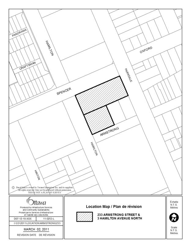
233 Armstrong and 3 Hamilton
In December 2010, staff was
approached by the prospective property owners, TEGA Homes, requesting to have
two properties removed from the CDP study area to permit further study of their
planning and redevelopment potential: 233
Armstrong Street and 3 Hamilton Avenue (see Document
7). These two properties occupy
three quarters of a complete block at the northern-eastern periphery of the
study area, bounded by Armstrong and Spencer Streets and Hamilton and Parkdale
Avenues. Currently, the site is occupied
by artisan and warehouse uses. The block
is also occupied by a restaurant/bar and apartment uses, including the Carleton
Tavern.
The properties were requested for removal from the CDP to further
address the development conditions affecting the redevelopment of the subject
properties. These include the
significant clean-up required for the contamination existing on-site, building
height beyond the eight storeys or 27 metres proposed by the CDP, and economically
feasibility of redevelopment.
Staff concluded that the results
of the time, work and efforts conducted with the broad Wellington West
community members, notably the Hintonburg community, needed to be respected and
it would be inappropriate at this late stage in the process to exclude the
subject sites from the CDP.
The subject site is within a
Mixed-Use Centre designation, and therefore, any proposed development is
expected to intensify the site relative to its existing pattern of
development. In a Mixed-Use Centre, the
highest density and highest heights would be at the rapid transit station, and
then decrease within the Mixed-Use Centre as development moves outward from the
rapid transit station. In line with
that, the height proposed in the draft CDP for this area is eight storeys,
which has been accepted by the community.
Staff recognizes that the subject site has some significant
contamination challenges and encourage the property owners to explore and
utilize the City’s Brownfields Program to help address these challenges.
Any forthcoming redevelopment
application for the sites at 233 Armstrong Street and 3 Hamilton will be processed
in the context of the West Wellington CDP bearing in mind the possible costs of
environmental remediation and the means to accomplish it, and that additional
height and/or density above that stated in the CDP may be appropriate. The process would include extensive
consultations with local residents and the Hintonburg Community Association.
Correspondence submitted by the property owner’s
consultant regarding this matter is provided in Document 5.
RECOMMENDATION 1b) Secondary Plan
Recommendation 1b) is to approve
the Official Plan Amendment (OPA) to add a Secondary Plan to Volume 2A to
implement the Wellington Street West CDP.
The Secondary Plan will include those parts of the CDP that establish
the vision and the planning and design policies for the General Mainstreet, and
also four specific nodal areas of the mainstreet including: 1) West Wellington Area, 2) Parkdale Park
Area, 3) McCormick Park Area and 4) Somerset Square Area. The Secondary Plan is detailed in Document
3.
The Official Plan amendment is
divided into three primary parts: Part A
- The Preamble, which provides the purpose, location and basis for the OPA;
Part B - The Amendment, which provides the land use and design policies for the
study area; and, Part C - The Appendix, which contains the implementation
strategy including matters such as: zoning amendments, streetscaping
improvements, and actions of further work to be undertaken by City
departments.
Notwithstanding that the
Wellington Street West Secondary Plan will become part of the Official Plan;
the CDP will continue to be a stand-alone Council-approved policy document for
the area. It provides the comprehensive policy directions to guide and evaluate
future private sector development and public works undertakings within the CDP
study area.
RECOMMENDATION 1c) Zoning By-law Amendments
Recommendation 1c) is to approve
an amendment to the Zoning By-law 2008-250, as detailed in Document 4, to
implement the zoning recommendations of the CDP. The CDP's zoning recommendations attempt to
address both resident and developer concerns in terms of the Official Plan's
intensification and compatibility policies.
Some of the key factors considered in developing the recommendations
include: the characteristics of each character area, the nature of the
adjoining land use, scale and character of adjacent built form, and the general
depth of lots and development feasibility.
Property owners affected by the
CDP's proposed zoning amendments, as well as the general public, were notified
during the Zoning By-law amendment circulation in May 2010 and again in April 2011
which included the notification published in City-wide newspapers, The Ottawa
Citizen and Le Droit,
Revision to Zoning Changes
National Capital Commission (NCC)
parcel – 355 Island Park Drive
A late technical comment was
received from NCC objecting to a rezoning of a small parcel of their land at
355 Island Park Drive (noted in Document 4, as Item #5). This parcel is part of a broad, on-going NCC
undertaking called the Capital Urban Lands Master Plan (CULMP) that has not yet
been finalized. Therefore, the NCC
requests that no changes in zoning on federal lands be advanced by the City at
this time. The NCC further notes that
upon completion of the Phase 2 of their study, the City and the NCC may work
towards making any amendments to the City’s Zoning By-law as a comprehensive
set of changes.
Due to the late receipt of this
comment, staff was unable to amend the affected documents, but will have this
item removed accordingly, prior to the Council meeting of May 11, 2011.
RECOMMENDATION 2) Heritage
Protection
Recommendation 2) directs the
City's Heritage Services Unit to undertake specific tasks including to:
a)
Submit the list of buildings to be added to the
Heritage Register, as noted in Appendix 1 of the Wellington Street West CDP,
for review and approval to OBHAC; and to present that approved list to City
Council for adoption.
b)
Conduct a heritage assessment of 1137 Wellington Street
(the present Senior Support Services Centre)
RECOMMENDATION 3) Asset Rationalization – 1137 Wellington Street
Recommendation 3) directs the
Real Estate Partnership and Development Office to undertake an asset
rationalization process to determine the long-term capital and operating
viability of 1137 Wellington Street (the present Senior Support Services
Centre). The CDP identifies certain elements
of the building and site design that limit opportunities to better coordinate
how the park and building interrelate with each other,
therefore limiting the potential of both the park and the building.
The CDP also advises that in the
long term, if 1137 Wellington Street represents little or no heritage value,
its removal may offer a rare opportunity to increase an existing park’s size,
and/or find an alternative use for the 1137 Wellington Street site and its
relationship to the street and the park.
Finding available green space in the urban area as the population
increases is an on-going challenge. The
value of this and other options should be explored.
ENVIRONMENTAL
IMPLICATIONS
Adoption of the OPA will
facilitate the implementation of the Wellington Street West CDP which is intended
to help enhance the planning area for residents, business owners, shoppers, and
visitors alike. It will guide and direct
future streetscape improvements, enhance the pedestrian culture and environment
including locations for new plaza spaces, and protect existing green areas
within the corridor.
RURAL IMPLICATIONS
N/A
CONSULTATION
Notice of the CDP and the
applications for Official Plan Amendment and the Zoning By-law Amendments were
carried out in accordance with the City’s Public Notification and Consultation
Policy. The Ward Councillor is aware of
this application and the staff recommendation.
The City did not receive any opposition to the proposed CDP document, Secondary
Plan and Zoning amendments. Comments of
clarification or concern are noted with responses in Document 5, “Consultation
Details”.
A summary of the public
consultation program and public circulations to date is also detailed in
Document 5. These include the comments
received from the Final Public Open House (May 12, 2010) and comments from two
public circulations (April 23, 2010 and February 18, 2011).
COMMENTS BY THE WARD COUNCILLOR(S)
Katherine Hobbs
Councillor, Ward 15 –
Kitchissippi
Comments on Wellington Street
West Community Design Plan
I want to thank all those involved
in the lengthy process that led to the creation of this community design plan.
In particular, the work that was done to coordinate efforts between the
Wellington Street reconstruction project and the Neighbourhood Planning
Initiative. It is a testament to how City departments can work together to
create projects that are bigger than the sum of their parts. With the
completion of the Wellington Street reconstruction this summer through to the
Somerset Bridge we can all be proud of a strong spine running through
Kitchissippi. As new development connects Westboro Village and West Wellington,
we can be confident of a strong future ahead for area businesses and enhanced
liveability for its residents. In many ways this CDP is the culmination of a
two decade long rejuvenation of Hintonburg and West Wellington that has seen
new small businesses develop and existing ones thrive as our main street has
become a destination for the city as a whole
Using this CDP as a common
language between the City, the community and developers I look forward to
working proactively to grow our community so that new families, new businesses,
new artists and new Canadians will be welcomed to the community while improving
quality of life for existing residents.
Going forward, I expect
communities to proactively define the community benefits they desire and for
developers to work with their neighbours to develop in a manner that delivers
these benefits for our growing neighbourhoods. In able to do so, references
to community benefits must be softened from “community benefits identified in
the Community Design Plan” to “community benefits, including those identified
in the Community Design Plan” (11.3.1, 2).
I look forward to the Parkdale
Market to be developed into a strong Mixed-Use Centre with a variety of new
businesses and an enhanced market. Pivotal to this is decontamination of
brownfield sites and preservation of rare gems of Hintonburg’s industrial past.
To achieve this, all parties must be engaged in a dialogue to produce a dynamic
environment for Kitchissippi and Ottawa. As part of this, provision of
parking through shared use of parking should also apply to new developments to
encourage the maximum use of parking for the benefit of the community and local
businesses (11.3.3, 11).
As there is little green space
directly abutting Wellington Street West, I am encouraged by the rezoning of
Somerset Square to parkland. This is a pivotal asset in the community which
must be encouraged and improved through the development process. In addition,
the provisions for the enhancement of green space in the corridor between
McCormick Park and the Bethany Hope Centre are welcomed, as they provide a rare
breathing space along the street. As such, I would hope any new development
would enhance this space either in area or quality, perhaps this is something
that could be protected through some degree of set-back requirements.
LEGAL/RISK MANAGEMENT IMPLICATIONS
There are no legal/risk management implications
associated with this report.
CITY STRATEGIC PLAN
While the Wellington Street West
Community Design Plan indirectly supports a number of Strategic Plan priorities
and objectives, the following summarizes those that are directly affected as a
result of CDP planning and design policies when implemented:
Sustainable, Healthy and Active City
Objective 3: Expand the amount of the City-owned green
space in Ottawa
Objective 6: Require walking, transit and cycling oriented
communities and employment centres
Objective 7: Set a high-level and a proactive municipal
response to meet the social services, social housing, supported living and
public health needs of Ottawa residents
Planning and Growth Management
Objective 1: Manage growth and create sustainable
communities by:
·
Becoming
leading edge in community and urban design
·
Ensuring
that new growth is integrated seamlessly with established communities
TECHNICAL IMPLICATIONS
N/A
FINANCIAL IMPLICATIONS
There are no direct financial
implications associated with this report.
The Wellington Street West CDP recommends two follow-up studies to
implement the Plan (outlined in Recommendations 2b and 3). It is expected that these will be conducted
through existing staff resources when these studies come forward in future work
programs.
SUPPORTING
DOCUMENTATION
Document 1 Location Map
Document 2 Wellington Street
West Community Design Plan (on file with the City Clerk and distributed
separately)
Document 3 Proposed Official Plan Amendment
Document 4 Zoning By-law Amendments
Document 5 Consultation Details
Document 6 Location Map: 7 Hinton Avenue and 6 Hamilton Avenue
Document 7 Location Map: 233
Armstrong Street and 3 Hamilton Avenue
DISPOSITION
Planning and Growth Management
Department to:
·
Undertake the follow-up implementation measures
outlined in the CDP that are its responsibility;
·
Prepare implementing by-laws;
·
Prepare the by-law adopting the Official Plan
Amendment (OPA) and Zoning By-law Amendments, forward to Legal Services, and
undertake the statutory notification.
·
Notify persons who made oral or written
submissions at Planning and Environment Committee and all persons and public
bodies who requested to be notified of the amendments;
·
Advertise the adoption of the OPA and the
passing of Zoning By-law amendments.
City Clerk and Solicitor
Department, Legislative Services, to notify the owner, applicant, OttawaScene.com, 174 Colonnade Road,
Unit #33, Ottawa, ON K2E 7J5,
Ghislain Lamarche, Program Manager, Assessment, Financial Services Branch (Mail
Code: 26-76) of City Council’s decision.
Legal Services to forward the
implementing by-laws to City Council.
LOCATION MAP DOCUMENT
1

PROPOSED OFFICIAL PLAN AMENDMENT DOCUMENT
3
Utilisation
Du Sol
THE STATEMENT OF COMPONENTS
PART A – THE PREAMBLE,
introduces the actual Amendment but does not constitute part of Amendment No. X
to the City of Ottawa Official Plan.
PART B – THE AMENDMENT,
consisting of the following text and maps constitutes the actual Amendment No.
X to the City of Ottawa Official Plan.
PART C – THE APPENDIX,
does not form part of the Amendment but is provided to clarify the intent and
to supply background information related to the Amendment.
Part
A – Preamble
1.0 Purpose
The purpose of this
Official Plan Amendment is to implement the land use and urban design
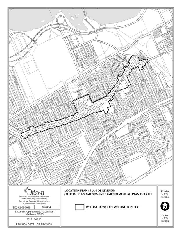
components of the Wellington Street Community Design Plan by adding a new
Secondary Plan to Volume 2A of the City’s Official Plan.
2.0 Location
This amendment
applies to properties adjacent to Wellington Street between Island Park Drive
and Breezehill Avenue, and to properties south of Spencer Street between
Holland and Parkdale Avenues to Wellington Street, as shown on the location map
below.
3.0 Basis
The Wellington Street West Community Design Plan was
undertaken for three reasons:
1.
The study area is designated primarily
Traditional Mainstreet and also Mixed Use Centre. According to the City’s Official Plan
policies for growth management, such areas of the city will experience intensification
and change over time.
2.
The Wellington Street Infrastructure
Renewal project, including road reconstruction and streetscaping, was scheduled
to begin its planning within the same year.
3.
The Neighbourhood Planning Initiative
(NPI), a pilot project in public consultation and participatory planning
focussing primarily on social and facility planning issues was scheduled to
begin in the same year.
The timeframe of each of the projects
provided a unique opportunity to align important project components to achieve
more comprehensive and efficient results, including: scoping, public
consultation and collaboration, data collection, information analysis, issue
resolution, recommendations, and implementation.
The Community Design Plan undertaken for the
community along Wellington Street identified a specific vision, goals and
policies that will guide how growth, intensification and change will occur.
The attached Wellington Street Secondary Plan
contains those land use and design policies required to support the
implementation of the approved Community Design Plan.
Part
B – The Amendment
1.0 Introductory
Statement
All of this part of this document entitled
Part B – The Amendment consisting of the following text and the Secondary Plan
at Appendix A constitute Amendment No. ___ to the City of Ottawa Official Plan.
2.0 Details
of the Amendment
The Official Plan of the City of Ottawa
Volume 2A – Secondary Plans is hereby amended by adding:
a. to the Table of Contents of the Secondary
Plans for the Former City of Ottawa the following title:
“Wellington Street West”
b. as
a new section next after the last approved Secondary Plan in Volume 2A of the
City’s Official Plan, the “Wellington Street West Secondary Plan” attached at
Appendix “A” to this amendment.
Part
C – Implementation and Interpretation
The relevant policies of Section 5 - Implementation
of the City’s Official Plan apply to this amendment and the attached Wellington
Street West Secondary Plan.
APPENDIX A
11.0 WELLINGTON
STREET WEST
11.1.
Introduction
11.2.
The Planning Area
11.3.
Land Use and Design Policies
11.3.1 General Mainstreet Policies
11.3.2 West Wellington Area Policies
11.3.3 Parkdale Park Area Policies
11.3.4 McCormick Park Area Policies
11.3.5 Somerset Square Area Policies
11.1 INTRODUCTION
The Wellington Street West
Secondary Plan is a guide to the long-term design and development of both the
Wellington mainstreet corridor in general, and four specific areas within it,
including direction on issues of: land
use, built form, sidewalks, plazas and open spaces, and heritage. The Secondary Plan provides a framework for
change that will see this area develop towards the vision that the community
desires while meeting the planning objectives of the City’s Official Plan. The policy directions of this plan also
support the broader objectives of the Wellington Street West Community Design
Plan (CDP). This Secondary Plan is to be
read and interpreted as City Council’s policy direction for municipal actions,
particularly in the review of development proposals, zoning changes,
applications to the Committee of Adjustment and the undertaking of public
works.
This Secondary Plan provides the legal
framework that supports the Wellington Street West CDP, a joint staff-community
effort to develop a vision, objectives, and planning and design policies and
guidelines for an attractive, vibrant and sustainable traditional
mainstreet. The CDP includes detailed
information on existing conditions, context, design issues, vision and the
intent of policy direction that is important for interpreting and supplementing
this Secondary Plan to ensure an appropriate balance of intensification and
compatibility.
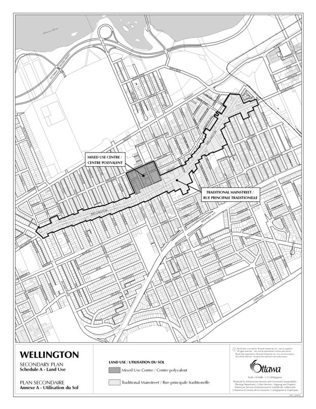
11.2 THE PLANNING AREA
The Wellington Street West
Secondary Plan defines the extents of the traditional mainstreet designation in
the Official Plan and provides greater detail as to how the mainstreet
objectives will be achieved. The
Secondary Plan also includes adjacent areas bounded by Wellington Street,
Holland Avenue, Parkdale Avenue, and Spencer Street that are influenced by
their proximity to the mainstreet. The
area is described by the land uses defined in the attached Schedule A – Land
Use.
11.3 LAND
USE AND DESIGN POLICIES
The
following provides the policy direction for the Wellington Street West
mainstreet corridor in general, as well as for the four identified key areas of
the mainstreet, as described in the attached Schedule B –Specific Policy Areas.
11.3.1 GENERAL MAINSTREET POLICIES
General
1.
Notwithstanding
the policies of the Official Plan, the land uses for the Traditional Mainstreet
and Mixed-Use Centre in the Wellington West area are designated on Schedule A –
Land use of this Plan.
Built form
2.
The maximum building height for
all new buildings within the Traditional Mainstreet will be six (6) storeys or
20 metres, except where identified by the specific area policies below. In those cases, the City may consider a
zoning by-law amendment to those properties to increase the maximum building
height to a maximum of nine (9) storeys pursuant to Section 37 of the Planning
Act where one or more community benefits identified in the Community Design
Plan are secured through agreement with the City and will be provided at the
time of development.
3.
New buildings over four (4) storeys
within the Traditional Mainstreet and Mixed-Use Centre areas shall incorporate
architectural articulation and details to form a two (2) to three (3) storey
base to ensure compatibility with the existing low-rise, human-scale buildings
in order to be consistent with the built form vision for these areas.
4.
In
order to ensure that the design of new or renovated buildings integrate into
the existing building fabric of the street and maintain an urban village
character, proponents shall demonstrate how the key elements of scale and
detail from the traditional one (1) to three (3) storey buildings and the
narrow lot sizes of the Wellington West corridor have been incorporated into
the building design.
Sidewalks and plazas
5.
In order to ensure the comfort and
safety of pedestrians throughout the length of the mainstreet, additional
sidewalk or plaza space for people shall be considered by the City through
either (i) increased building setbacks at grade with new development proposals
during a Site Plan Control application, or (ii) with sidewalk widenings within
the right of way at the time of alterations to road geometries by Public Works.
AREA-SPECIFIC
POLICIES
The specific policy areas are described by Schedule B
- Specific Policy Areas of this Plan.
11.3.2 West Wellington
Area Policies
The West Wellington
Area values a high-quality pedestrian environment based on a human, low-scale
character; a greener, public-friendly streetscape; and establishment of
community gateway features to reinforce the area as a vibrant activity node for
the local and broader Ottawa community.
Built form
1.
Redevelopment
along the northern boundary of 345 Carleton Avenue will be limited to low-rise
residential infill and shall provide building massing and façade details that
respond to and enhance the surrounding residential homes on Garrison Street and
Carleton Avenue to ensure a well-designed transition between the mainstreet
character and its use and the surrounding residential uses.
2.
The City may consider a zoning by-law
amendment to the properties at 345 Carleton Avenue, 1451 Wellington Street and
369 Island Park Drive to increase the
maximum building height pursuant to Section 37 of the Planning Act where one or
more community benefits identified in the Community Design Plan are secured through
agreement with the City and will be provided at the time of development.
Sidewalks and plazas
3.
Redevelopment
at the southwest corner of 345 Carleton Avenue shall establish
a new publicly accessible open space, such as an plaza, to provide a place for
people to rest and meet in the west end of the mainstreet corridor.
Gateway architecture
4.
Redevelopment
at 1451 Wellington Street shall require the west façade of a new building to be
integrated with a redesigned, City-owned public open space located at the northwest
corner of Island Park Drive and Wellington Street, at the base of Rockhurst
Avenue, to provide an animated place for people to meet
or rest at the western gateway to the corridor.
Public lanes
5.
City-owned rear lanes immediately
behind mainstreet properties (parallel to Wellington Street) between Western Avenue and Huron Avenue will
remain open and will not be disposed of in order to ensure that important
access for the mainstreet properties is preserved, and to improve opportunities
for parking, servicing and loading for both existing and future developments.
11.3.3 Parkdale Park
Area Policies
The Parkdale Park
Area will emerge as the civic and commercial heart of the broader Wellington
West community. Accordingly, the
Wellington-Holland-Parkdale crossroads and Parkdale Park and Market mixed use
area will be designed and developed with more desirable and efficient land uses
and buildings, a distinguishing character, and improved comfort and safety for
pedestrians.
Traditional Mainstreet Area
Built form
1.
To encourage the redevelopment of
underutilized properties at or near the intersections of Parkdale and Holland
Avenues, the zoning by-law will establish a minimum building height of four (4)
storeys to ensure a minimal level of intensification is achieved in this key
area.
2.
The City may consider a zoning by-law
amendment to the properties fronting the corners of Parkdale and Holland
Avenues at Wellington Street to increase the maximum building height pursuant
to Section 37 of the Planning Act where one or more community benefits
identified in the Community Design Plan are secured through agreement with the
City and will be provided at the time of development.
3.
Infill and/or redevelopment with
buildings facing onto the south side of Parkdale Park and Market is encouraged
and shall create an active frontage and extend street level pedestrian-friendly
uses northward from Wellington Street in order to provide a strong urban frame
around the park.
Sidewalks and plazas
4.
The intersections at Parkdale and
Holland Avenues on Wellington Street will become key activity nodes, therefore,
redevelopment at these corners shall establish pedestrian-oriented, publicly
accessible spaces to animate, attract and retain people. Small plazas, wider sidewalks, and/or patios
shall be incorporated into the site design of new proposals.
Gateway architecture and signage
5.
Architectural and other visual
features shall be introduced in new developments that mark arrival at the
Parkdale and Holland Avenue gateways to the Wellington Street West community.
Mixed-Use Centre Area
Land use
6.
The ground floor area of commercial
uses proposed by new infill development shall be comparable to nearby
mainstreet areas to support small-scale commercial operations and to discourage
large format retail uses.
7.
The maximum building height for all
new buildings on Hinton and Hamilton Avenues, between Wellington and Armstrong
Streets, will be six (6) storeys or 20 metres.
8.
Building height in the area bounded by
Holland and Parkdale Avenues and Armstrong and Spencer Streets shall have a
maximum of eight (8) storeys or 27m to provide a transition from the taller
buildings near Scott Street down to the traditional mainstreet building height
of Wellington Street.
9.
Notwithstanding
that a portion of the building at 7 Hinton Avenue shall be protected through
designation under Part IV of the Ontario Heritage Act and notwithstanding
paragraph 11.3.3.8 above regarding a maximum building height, the entire
property bounded by Spencer, Hinton, Armstrong and Hamilton shall retain its
rights to develop an area equal to the Floor Space Index (FSI) of an eight (8)
storey building, as described in Policy 3.5.4, A8 and A10 of the Wellington
Street West Community Design Plan. Moreover, under this policy, a
transfer of density from and measured on 7 Hinton Avenue shall permit
additional building height at 7 Hinton Avenue and/or to 281 Armstrong Street
until the FSI rights at 7 Hinton have been fully exercised on either property.
10.
Buildings
on these blocks will incorporate a base, body and top
to ensure an attractive, pedestrian-scaled building base, streetscape
and appropriate street-to-height ratio.
Parking
11. This
Plan encourages and permits shared parking on the existing surface parking lots
in the Mixed- Use Centre area, as per Schedule A, to make better use of
underutilized land, prior to their redevelopment. This will ensure adequate,
convenient parking for the variety of uses in the area, throughout the day.
11.3.4 McCormick Park Area Policies
The McCormick Park
Area will continue to be the “greenest” part of Wellington Street and a
community facilities and services node.
It is anchored by the neighbourhood-oriented McCormick Park; the
spacious front yards of Grace Manor, the Bethany Hope Centre, and the Queen of
the Most Holy Rosary Parish; a unique grouping of Hintonburg heritage
buildings, and a variety of public facilities and services.
Built form
1.
In order to ensure a
well-designed transition between the mainstreet character and uses and the
surrounding residential uses, infill and/or redevelopment of through lots
facing onto Grant Street, between Parkdale Avenue and McCormick Street, is
encouraged and shall be limited to low-rise infill along the south side of
Grant Street. The building massing and façade details shall complement the
residential uses on the north side of the street.
2.
Infill redevelopment at the corner of
Rosemount and Wellington (1134 Wellington) is encouraged and shall provide a high quality, creative design that ensures
(i) a sympathetic interface to the nearby buildings of heritage
value along the mainstreet and (ii) a prominent vista terminus from several
directions, in order to maximize the unique location and opportunities afforded
by this site.
3.
New buildings on properties fronting
onto McCormick Park shall provide façade elements, such
as windows, doors, porches, and balconies, in order to establish an urban frame
that provides a sense of enclosure, people presence, and safety for the
pedestrians and park users.
Open spaces within front yards
4.
This plan recognizes the importance of
protecting and enhancing the unique green streetscape character created by the
existing front yards of the Grace Manor and Bethany Hope Centre (1134 and 1140
Wellington Street) and St. George’s Home (1153 Wellington Street).
5.
This unique green area of Wellington
Street depends on the continuity of these front yards, which affords potential
to link them with McCormick Park to strengthen and expand this street
character.
6.
The public enjoyment of these green
spaces will be maximized by improving their utility and/or aesthetic. This improvement may be, for example, by
programming the land for public use through the collaboration of property
owners, the community and the City of Ottawa and/or through land acquisition by
the City.
11.3.5 Somerset Square Area Policies
The Somerset Square
area is envisioned as the node of community activity, particularly given the
presence of an existing public open space, its eastern gateway location, its
proximity to a future light rail transit station, and the opportunity for
redevelopment on several underutilized properties. New development will be encouraged to
incorporate animated and activity-generating land uses, buildings and spaces
that take advantage of its transit access.
Built form
1.
Redevelopment of properties fronting
the corners of Bayswater Avenue at Wellington and Somerset Streets shall
exhibit gateway architectural design that responds to a location with a
prominent vista terminus from several directions. The City may consider a zoning by-law
amendment to increase the maximum building height pursuant to Section 37 of the
Planning Act where one or more community benefits identified in the Community
Design Plan are secured through agreement with the City and will be provided at
the time of development.
2.
Infill redevelopments on through lots,
on blocks bounded by Wellington and Armstrong Streets and Bayswater and Merton
Avenue, shall re-establish the traditional urban grain where open spaces run
through the centre of the block(s) and buildings are built around the perimeter
of the block close to the street. This
creates a space and buffer from the distinct forms, characters and uses found
on mainstreet properties versus the existing residential neighbourhood to the
north.
3.
At the time of redevelopment, a
publicly accessible pathway shall be encouraged at 999 Wellington Street to
provide a pedestrian connection to and from the neighbourhood blocks to the
north of Armstrong Street.
Public open space
4.
Somerset Square shall be protected in
perpetuity in design and use as a public park for the community in order to
balance intensification and quality of life needs.
Open spaces within front yard setbacks
5.
The existing green space in front of
the St. Francis D’Assisi Church (1062 Wellington Street) is to be preserved and
protected for its continued and improved use as a valued publicly accessible
open space within the mainstreet corridor.
LIST OF ZONING BY-LAW CHANGES
AND LOCATION MAPS DOCUMENT
4
|
|
|
#
|
Address or Location
|
Existing Zoning
|
Proposed Zoning
|
|
|
|
|
|
Building height (maximum):
- Island Park Drive to Holland Avenue: 18m
- Holland
Avenue to Breezehill Avenue: 19m, 15m
(TM[126])
Building height (setback):
for that part of a building above the 4th storey
or 15 metres the minimum front yard setback is 2 metres
|
Building height (maximum):
20m
|
|
2
|
All properties in
the study area in the TM Zone (between Island Park Drive and Breezehill
Avenue), except at those addresses listed in #6.
|
Maximum
front yard setback:
2 m
|
Maximum front yard setback:
3 m
|
|
3
|
345 Carleton
Street, along the southside of Garrison Street
|
Minimum rear yard setback:
no minimum
|
Within 20 metres of the lot line adjacent to Garrison Street,
a building wall that faces the street must be setback at least 3m but no
greater than 5.5m from that lot line
|
|
4
|
345 Carleton
Street, along the southside of Garrison Street
|
Building height (setback):
at and above the 4th storey or 15 metres,
whichever the lesser, that part of the building abutting the rear yard must
stepped back from an R1, R2, R3 or R4 Zone so that no part of the building
projects beyond a 45 degree angular plane measured from the top of the 4th
storey where it abuts the rear yard.
|
Building height (setback):
|
|
|
|
|
|
|
|
|
5
|
Northeast
corner at Island Park Drive and Wellington Street; including, 355 Island Park
Drive (NCC-owned) and area of road closure at the south terminus of Rockhurst
Road (City-owned right of way)
|
TM Zone Provisions
|
Change to 01 Zone
Permitted uses:
park
community garden
environmental preserve and education area
|
#
|
Address or Location
|
Existing Zoning
|
Proposed Zoning
|
|
6
|
Properties fronting onto southside of Parkdale Park, abutting public
right of way
390 Parkdale Avenue; 1187 Wellington Street;
21 Hamilton Avenue
|
Minimum rear yard setback:
7.5m
Minimum corner side yard setback: 3m
|
Minimum rear yard setback:
2m to a 3m
maximum
Minimum corner side yard setback : 2m
to a 3m maximum
|
|
7
|
390 Parkdale
Avenue; 1134, 1186, 1230, 1236 Wellington Street
|
Maximum front yard setback:
2m
|
Minimum front yard setback: 3m
|
|
8
|
390 Parkdale
Avenue; 1134, 1186, 1230, 1236 Wellington Street
|
Minimum building height 6.7m for a distance of 20m from
the front lot line as set out under subsection 197(5) below
|
Minimum building height of four (4) storeys, or 15m, which
ever the lesser
|
|
9
|
All TM Zone
properties on the south side of Grant Street between McCormick Avenue and
Parkdale Avenue; specifically, properties facing north onto Grant Street.
|
Minimum rear yard
setback requirement: no minimum
|
The minimum yard setback, for the ground floor building,
from the lot line adjacent to Grant street is 3m but no greater than 5.5m
from that lot line
|
|
10
|
All TM Zone
properties on the south side of Grant Street between McCormick Avenue and
Parkdale Avenue; specifically, properties with north frontage onto Grant
Street.
|
Building height (setback):
at and above the 4th storey or 15 metres,
whichever the lesser, that part of the building abutting the rear yard must
stepped back from an R1, R2, R3 or R4 Zone so that no part of the building
projects beyond a 45 degree angular plane measured from the top of the 4th
storey where it abuts the rear yard.
|
Building height (setback):
|
|
11
|
1134 Wellington
Street at parking lot on the corner of Wellington Street and Rosemount Avenue
(Grace Manor)
|
Minimum rear yard
setback: no minimum
|
|
|
12
|
Bayswater, between
Somerset and Wellington: 10 and 24 Bayswater
|
Maximum front yard setback: 2m
|
Minimum front
yard setback:
3m
|
|
13
|
Wellington,
between Spadina and Bayswater: 1
Spadina
|
Minimum rear yard
setback: no minimum
|
Minimum rear yard
setback:
3m
|
|
#
|
Address or Location
|
Existing Zoning
|
|
|
14
|
1092, 1098, 1106,
1108 Somerset Street
|
Minimum rear yard
setback: 7.5m
|
|
|
15
|
1092, 1098, 1106,
1108 Somerset Street
|
Maximum building
height: 20m
|
Maximum building
height: 4-storey or 15m, whichever is the lesser
|
|
16
|
1047, 1049, 1053,
1055 Somerset Street
|
Minimum rear yard
setback: 7.5m
|
|
|
17
|
Block of
Wellington, Armstrong, between Garland and Merton
|
Minimum rear yard
setback:
7.5m
|
|
|
18
|
1041 Wellington
Street, along the southside of Armstrong Street
|
Minimum rear yard setback:
no minimum
|
Within 20 metres of the lot line adjacent to Armstrong
street, a building wall that faces the street must be setback at least 3m but
no greater than 5.5m from that lot line
|
|
19
|
1041 Wellington
Street, along the southside of Armstrong Street
|
Building height (setback):
at and above the 4th storey or 15 metres,
whichever the lesser, that part of the building abutting the rear yard must
stepped back from an R1, R2, R3 or R4 Zone so that no part of the building
projects beyond a 45 degree angular plane measured from the top of the 4th
storey where it abuts the rear yard.
|
Building height (setback):
|
|
|
|
20
|
1140 Wellington
Street at
Bethany Hope
Centre(Salvation Army)
|
Maximum building height (m): no maximum; FSI 1.5
|
Maximum building
height: 6-storeys or 20m; remove FSI
|
#
|
Address or Location
|
Existing Zoning
|
Proposed Zoning
|
|
|
|
21
|
All properties
zoned IL8, in the study area, between Spencer and Armstrong Streets, and
Holland and Parkdale Avenue
|
IL8 [16] and IL8 [104]
|
Amend to change
the existing zoning to MC16 Subzone, retaining their exception provisions,
unless otherwise noted in these proposed zoning changes
|
|
22
|
All properties
zoned IL8 or MC, in the study area, between Spencer and Armstrong Streets,
and Holland and Parkdale Avenue
|
Maximum building
height:
IL8 [16]: 11m,
FSI 1.0
IL8 [104]: 13.5, FSI 2.0
MC: 19m, FSI 3.5
|
Maximum building
height : 8-storeys or 27 m,
whichever the lesser.
|
|
23
|
Properties at 7
Hinton Avenue and 281 Armstrong Street
|
7 Hinton
Avenue:
IL8 [16]: 11m, FSI
1.0
281 Armstrong Street:
IL8 [104]: 13.5,
FSI 1.0
Minimum Interior Side Yard and Rear Yard Setback :
i. For uses listed 203(1) abutting a residential or institutional
zone: 7.5m
ii. All other cases: 3m
|
7 Hinton Avenue
Maximum FSI: 6.1
281 Armstrong Street
Maximum FSI: 4.7
Notwithstanding Section 22, Despite the fact that the FSI
is calculated based on the area of the entire lot the only areas permitted
for development are Areas A and B on Schedule XX;
if in one area on Schedule XX the maximum floor area
permitted by the FSI is not developed or proposed for development, the
difference measured on the property on at 7 Hinton Avenue may be transferred
to the other Area on Schedule XX, permitting additional building height at 7
Hinton Avenue and/or to 281 Armstrong Street until the FSI of 7 Hinton has
been fully exercised on either property.
281 Armstrong Street:
Rear yard setback minimum (along western property line):
3m, for
storeys 1 to 3
7.5m, for
storeys 4 to 8
-for lots on Hinton Avenue, a lot line that abuts Hinton
Avenue is to be treated as the front lot line
|
|
24
|
All properties
zoned IL8 or MC, in the study area, between Spencer and Armstrong Streets,
and Holland and Parkdale Avenue
|
IL8:
Minimum Front and
Corner Side Yard Setback: 3m
Minimum Interior
Side Yard and Rear Year Setback: 3m
MC:
Building setback:
no minimum
|
Minimum ground floor setback from façade facing a public
street: 2m
Minimum building stepback, above the 3rd and 6th
storey, when building height is over 4 storeys: 2m
Rear yard setback minimum:
3m, for
storeys 1 to 3
7.5m, for
storeys 4 to 8
For through lots, the lot lines abutting the street are
considered a front lot line
|
|
|
|
25
|
All existing MC12
Properties in the study area, bounded by Holland and Parkdale Avenues and
Armstrong and Wellington Streets
|
Maximum building
heights
MC12[106]: 19,
FSI 3.5
MC12[110]: 19, FSI
3.0
Max FSI, only commercial:1.5
Max.FSI, other cases: 3.0
Minimum building
setback: no minimum
|
Maximum building height:
20m;
Remove previous FSI provisions
Minimum building stepback above the 3rd storey,
when building height is over 4 storeys: 2m
|
|
|
|
|
|
|
|
|
26
|
All existing MC12
Properties in the study area, bounded by Holland and Parkdale Avenues and
Armstrong and Wellington Streets
|
Minimum required rear yard setbacks for residential and
mixed use buildings: 3m
|
Rear yard setback minimum:
3m, for
storeys 1 to 3
7.5m, for
storeys 4 to 8
For through lots, the lot lines abutting the street are
considered a front lot line
|
|
27
|
All existing MC12
and IL8 Properties in the study area, bounded by Holland and Parkdale Avenues
and Spencer and Wellington Streets
The above maximum
does not apply to 7 Hinton Avenue.
|
The cumulative
gross floor area occupied by retail
stores must not exceed 10% of the
maximum permitted GFA for commercial space; where a lot contains both
residential and commercial uses, the maximum permitted cumulative total gross
floor area of the commercial uses is 50% of the total lot GFA on the lot
|
Maximum Gross Floor
Area per unit of retail, service-oriented commercial uses, and office uses:
200 m²
Additional office
uses are permitted on any floors above the ground floor.
Note:
The above maximum
does not apply to 7 Hinton Avenue.
|
|
28
|
All existing MC12,
MC and IL8 Properties in the study area
|
Minimum parking requirements vary, as per Section 101
|
Parking spaces required or provided in the MC16 Subzone
may be available for parking purposes to any land use located within the MC16
Subzone.
Note: MC16 is proposed zoning encompassing the
areas presently zoned MC12 and IL8
Please review the proposed MC16 Subzone, appended to this
Table.
|
#
|
Address or Location
|
Existing Zoning
|
Proposed Zoning
|
|
29
|
Parkdale Market
area, 366 Parkdale Avenue
|
MC12[105] F(4.5)
All uses other than a retail store limited to an outdoor
public market
|
L1 [105] – Community Leisure Facility Zone
Retail store limited to an outdoor
public market as an additional permitted use; remove FSI provision.
|
|
|
|
30
|
Somerset Square
|
Permitted uses:
community centre
community garden
day care ,emergency service
library, municipal service centre, park,
recreational and athletic facility, sports arena
|
Change to 01 Zone
Permitted uses:
park
community garden
environmental preserve and education area
|
Subsection
192 is amended by adding the following subzone:
MC16 SUBZONE-
Parkdale Park Subzone
(16) In the MC16 Subzone:
(a) The following uses are prohibited:
amusement centre
bar
multiple attached dwelling
nightclub
parking garage
parking lot
shelter
sports arena
(b) For the purposes of calculating required
parking, a theatre lobby is not considered to constitute gross floor area,
(c) Parking spaces required or provided in
the MC16 Subzone may be available for parking purposes to any land use located
within the MC16 Subzone,
(d) Section
110 (Landscaping Provisions for Parking Lots) and Section 113 (Loading Space
Rates and Provisions) do not apply.,
(e) Parking
spaces may be shared between uses in the MC16 Subzone, and the cumulative total
of parking spaces required for those uses may be reduced from that required in
Section 101 to the amount calculated using Table 192D below:
(i) multiply the number of parking spaces
required for the land use in Section 101
above by the percentages shown in
Table 192D for that use in each of the time periods,
(ii) repeat
(a) for each of the uses,
(iii) for each time period add the parking
space calculations for all the uses to
arrive at a cumulative total,
(iv) the largest cumulative total for all the
uses in any time period is the number
of parking spaces required for those uses,
(v) add
the total required parking spaces for all non-sharing uses to get the total required parking;
TABLE 192D – SHARED PARKING AS PERCENTAGE OF
REQUIRED PARKING DURING REPRESENTATIVE TIME PERIODS
|
|
|
|
|
|
I
Land Use
|
II
A.M.
|
III
NOON
|
IV
P.M.
|
V
EVENING
|
|
Weekday Period/
Percentage of Required Parking
|
|
(a) Office
|
100
|
90
|
95
|
10
|
|
(b) Retail
Store, Bank and Personal Service Business
|
50
|
75
|
75
|
65
|
|
(c) Restaurant
|
20
|
50
|
50
|
100
|
|
(d) Place of
Assembly
|
60
|
60
|
60
|
75
|
|
(e) Cinema
|
0
|
0
|
0
|
100
|
|
(f) Hotel
|
100
|
30
|
40
|
100
|
|
(g) Residential
Use-Building
|
85
|
60
|
60
|
100
|
|
|
|
|
|
|
Weekend Period/
Percentage of Required Parking
|
|
(h) Office
|
15
|
20
|
10
|
5
|
|
(i) Retail
Store, Bank and Personal Service Business
|
50
|
85
|
100
|
60
|
|
(j) Restaurant
|
10
|
45
|
45
|
100
|
|
(k) Place of
Assembly
|
60
|
70
|
70
|
100
|
|
(l) Cinema
|
0
|
0
|
70
|
100
|
|
(m) Hotel
|
90
|
30
|
40
|
100
|
|
(n) Residential
Use-Building
|
100
|
70
|
70
|
100
|
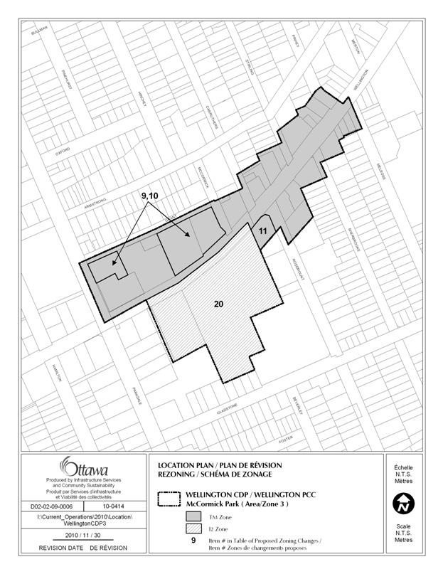
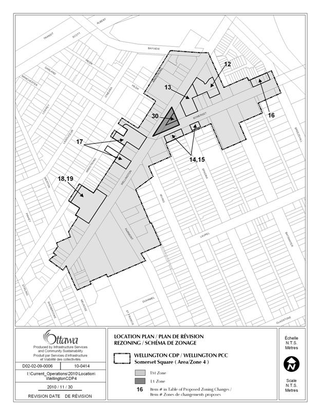
CONSULTATION DETAILS DOCUMENT
5
The
Wellington Street West CDP had an extensive public consultation program,
including the following components:
Open
Houses and Workshop
The City
sponsored four open houses for the Wellington Street West CDP, including three
that were jointly-held with the Neighbourhood Planning Initiative and the
Wellington Road Reconstruction Project.
·
February
24, 2007 - Joint Public Open House and workshop: Project introduction and issue
identification. Attendance in excess of 150
people.
·
June
19, 2007 – Joint Public Open House:
Presentation of Planning and Design Framework, including overall goals
and principles. Attendance in excess of 400
people.
·
June
18, 2008 – Joint Public Open House:
Presentation of the draft CDP vision, recommendations and implementation
issues. ; Attendance in excess of 250
people.
·
May
12, 2010 – Joint Public Open House: Presentation of the draft CDP document,
proposed Secondary Plan and proposed Zoning By-law amendments; attendance of 43
people.
Continuity Task Force (CTF) Meetings
City Planning staff held 14 meetings with the
CTF, the dedicated group of community representatives, to discuss the planning
and design issues running the length of the Wellington main street as well as
issues unique to specific locations, and to develop the recommendations and
policies of the CDP. This included two
meetings following the final Public Open House of May 12, 2010. Planning staff also participated with the CTF
in 35 other meetings that were either lead or jointly-lead by either the
Neighbourhood Planning Initiative (NPI) staff or the Wellington Road
Reconstruction staff to share information and to ensure continuity and
consistency between the projects.
Site Visits
Three site visits were conducted with the CTF
in May 2007 to walk the length of the CDP study area and to focus on three
different areas of the study area. The
purpose was to identify issues, opportunities and constraints for the corridor
and to serve as a basis for CTF meetings on each of four character/nodal areas
of the Wellington Street corridor. Other
similar site visits were organized by the Wellington Road Reconstruction
project which helped to complement the CDP process.
TECHNICAL CIRCULATION
National Capital Commission (NCC)
A late technical comment was received from NCC on
April 7, 2011. The NCC recognizes that zoning
amendments are proposed as a result of the on-going CDP exercise. In the list of proposed changes to the TM-
Traditional Mainstreet zone- there is a property in NCC ownership (#5- N/E
corner Island Park Drive and Wellington Street).
Island Park Drive is an NCC parkway and in the Plan
for Canada’s Capital is designated a Capital Parkway and scenic entry route.
The parkway network also forms part of the lands identified as “Capital Urban
Lands.
In view of the strategic and symbolic importance of
the Capital’s urban lands, the NCC has undertaken the preparation of the
Capital Urban Lands Master Plan (CULMP). The purpose of this master plan is to
define a vision, strategic directions, guidelines and development proposals for
the Capital’s urban lands in order to enhance the contribution they make to the
experience and unique living environment of Canada’s Capital. NCC is presently
in Phase 1 of the master plan, which includes the preparation of a vision
statement and a concept plan, as well as general guidelines and strategic
objectives for all lands contained in the Plan.
Given that the CULMP is on-going and the final
vocations and concept plans that will guide the development and improvement of
Capital Urban Lands as a whole is not finalized, the NCC requests that no
changes in zoning on federal lands be advanced by the City at this time (It is
the NCC position with regards to all of the lands under study in the CULMP).
Upon completion of the Phase 2 of this study, the City and the NCC may work
towards making any amendments to the City Official Plan or Zoning as a
comprehensive set of changes.
The NCC is unable to support any proposed Zoning
changes on federal lands which may be the subject of on-going federal Planning
Studies. The NCC asks that the existing zoning remain.
PUBLIC CIRCULATION
General Public Comments
The below table provides a summary
of comments received from the Final Public Open House May 12, 2010, as well as
consolidated comments received from public circulations to registered community
organizations and members of the public who identified an interest in the
project. Staff responses to the comments
are also provided.
|
|
Summary of Comment Sheets
from Final Public Open House (May 12, 2010)
Attendance: 43
|
|
|
|
Comment
|
Planning Response
|
|
1.
|
Concern
with lack of parking, and spill-over into the residential areas.
|
Development
of a parking strategy, including on-street parking, is the subject of a
City-wide study. However, the CDP
transportation study described a field study that was conducted. It found that utilization of the current
supply is highest for much of the corridor (between 80-100%) during Saturday
and weekday afternoon and midday peak periods.
The
CDP proposes a zoning amendment that will permit greater flexibility between
property owners in the Mixed Use Centre Zone to share parking spaces during
peak and off-peak hours, therefore, making more surface parking available
within the area. Similar shared
parking is also permitted within the TM Zone along Wellington Street.
Inappropriate
parking on public streets will continue to be addressed by Parking
Enforcement.
|
|
2.
|
No
mention of light pollution abatement education for the neighbourhood. What are the City’s future goals,
education/awareness plans, timelines.
|
Development
Review assesses development applications according to City guidelines. The City is not actively pursuing such
programs in the foreseeable future.
|
|
3.
|
The
CDP should not preclude the development of buildings containing large format
retail stores, for example, to accommodate a sizeable grocery store.
|
The
community’s vision, reflected in the CDP, is to reinforce an urban retail
format versus a suburban format. This
format has proven to be flexible for decades and has given Wellington Street
much of its character. The CDP
continues to permit commercial and retail uses and offers more retail
opportunity than the existing Zoning By-law.
Opportunities remain within the community to develop larger format
stores like grocery stores.
|
|
|
Summary of Comments to CDP
Proposals
|
|
|
4.
|
Gateway
locations and building height
Concern that every intersection can be interpreted
as a gateway, and therefore, qualifies for an increase in building height.
|
A
“gateway” refers to locations where the external architectural design of
buildings is a priority because of its high level of public visibility. Increased building height will not be
justified on this basis alone. A
location must possess other qualities such as lot size, immediate proximity
to a transit route, or distance from other uses. These could make them important candidate
sites for a achieving the City’s growth management goals as outlined in the
Official Plan. The CDP specifically
identifies those properties within the study area that being considered for
additional building height.
|
|
5.
|
Through-lots
between Wellington and local residential streets
Concern that through-lots will be permitted to
develop at TM zone heights and parking will dominate frontage onto the
residential street.
|
The
CDP has reviewed the major through-lots within the study area and developed
both policies and implementing regulations that encourage the infill of such
lots while ensuring that the setbacks and heights of new built form is in
scale and character with existing residential uses.
|
|
6.
|
Rental
affordable housing
Concern that all new development within the Study
area takes the form of a condominium with unaffordable units; desire to
maintain socio-economic diversity within the Study area.
|
Official
Plan policy encourages all new ownership housing and new rental housing to be
25% affordable. To support the
implementation of this, this CDP promotes the provision of affordable rental
housing as a public benefit in exchange for a limited increase in building
height at specific locations where such an increase is appropriate.
|
|
|
Issues relevant to
Specific sites
|
|
|
7.
|
Parking in
the Mixed Use Centre designation area of CDP study
Inefficient use of existing parking capacity of
private property
|
The
CDP proposes a zoning amendment that will permit greater flexibility between
property owners in the Mixed Use Centre Zone to share parking spaces during
peak and off-peak hours, therefore, making more surface parking available
within the area. Similar shared
parking is also permitted within the TM Zone along Wellington Street.
|
|
8.
|
Development
along Parkdale Avenue (between Armstrong and Spencer)
Concerns about building height and design impacts
on east side residential uses of Parkdale
|
The
CDP proposes an eight (8) storey building height limit, as well as 2m
building setback at the ground floor, third and sixth floors. The Parkdale road arterial right-of-way is
just under 20m. All of these create a
substantial buffer, transition and minimal impact from the Mixed Use Centre
designated area west of Parkdale Avenue to the General Urban Area east of it.
|
|
9.
|
7 Hinton
Avenue
Concerns about heritage value and building height
|
The
CDP recommends the heritage designation of the key components of 7 Hinton
Avenue. Furthermore, a new policy and
zoning amendment ensures that the design of any future redevelopment of the
site will protect and maintain the industrial architecture of this building
for continued public enjoyment.
The
proposed maximum 6.1FSI on the site allows the property owner to build the
equivalent floor area of an eight (8) storey building, that is the same
development potential being afforded to all property owners between Spencer and Armstong Streets and Parkdale
and Holland Avenues. There is design
guidance in place in the CDP to ensure that redevelopment of the site is
creative, sympathetic to the heritage building, and compatible with the
surrounding built form and uses.
This
site is within a Mixed-Use Centre designation. Any proposed development to intensify the
site is relative to its existing pattern of development. However, we would also expect that in a
Mixed-Use Centre, the highest density and highest heights would be at the
rapid transit station, and then decrease within the Mixed-Use Centre as
development moves outward from the rapid transit station.
|
|
10.
|
233
Armstrong (The Artisan)
Concerns about building height and design
|
The
CDP proposes an eight (8) storey building height limit, as well as 2m
building setbacks at the ground floor, third and sixth floors to ensure that
the design of a new building(s) is a suitable scale to the surroundings and
the vision for the area.
The
subject site is some distance from the rapid transit station. It also abuts Parkdale Avenue, which
separates the Mixed-Use Centre from the General Urban designation east of
Parkdale, an area of primarily two-storey homes (zoned as R4H Residential
Fourth Density). Policy 3.6.2 7J in
the Official Plan states “Ensure that an appropriate transition between the
Mixed-Use Centre and any surrounding General Urban Area occurs within the
Mixed-Use Centre.”
|
|
11.
|
McCormick
Park
Concerns
about potential expansion of McCormick Park to Wellington Street
|
The
CDP recognized that the City-owned building at 1137 Wellington Street
(presently occupied by the Seniors Support Centre) is at a key location. The CDP, therefore, recommends that its
condition and potential options regarding its future role be reviewed. It makes no recommendation on either the retention
of the building or expansion of the park, only that they be considered given
its past, present and future context.
|
Letters of Comments or Concern Received
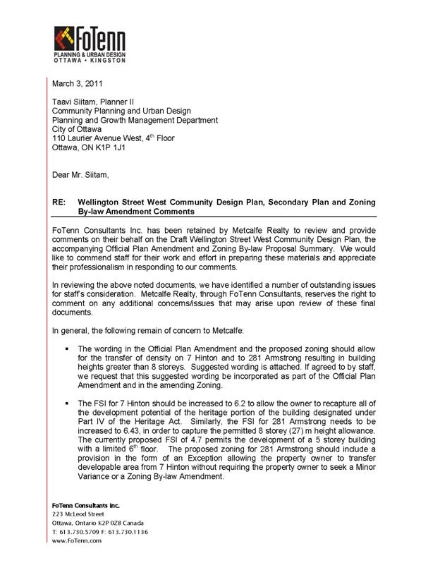
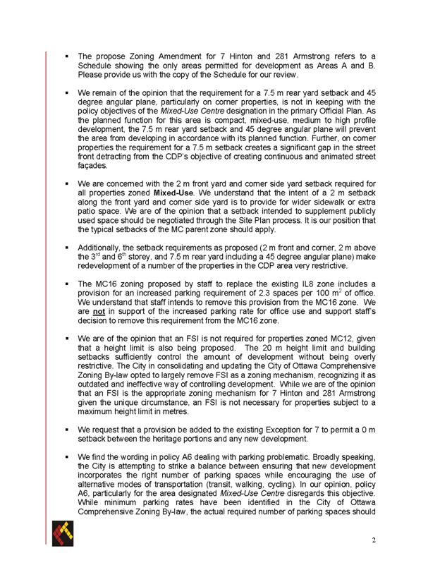
Hintonburg Community Association comments on the Wellington Street West
CDP,
OPA and ZBL
March 22, 2011
(In no particular order)
1. Community Benefits
under Section 37 Policy A5 (and elsewhere)
- ensure that it is clear that the community benefits listed
in the documents are only examples and
not exclusive
- the HCA intends to prepare a more detailed list of
desirable community benefits after discussion with the broader community
- REMOVE rental affordable housing which occurs
in several places– use ‘affordable housing’ instead
- we hope
to encourage limited equity ownership (e.g. Habitat for Humanity) and
non-profit ownership and rental housing to ensure affordability over time and
not just for the first owner
2. McCormick Park
- we do not support
the expansion of McCormick Park to Wellington Street
- recommendations to enhance signage and visibility from Wellington
St. are good
- building provides a buffer from busy street and a quieter
park and redevelopment would provide opportunity to link new building with the
park
- policies to encourage development around the edges of the
park are supported
3. Gateways and Nodes
- figure 3-1 (p. 42) is an improvement over the previous
version but the Legend still includes ‘Development node’ – none are shown and
none are wanted
- figure 3-5 (p. 48) – change to match 3-1 by removing the
‘nodes’ between and around the gateways and ‘nodes’ from Design goal 4
- ‘gateway’ is not well defined or understood; more emphasis
needs to be placed on design quality, rather than height
4. Green spaces
- what is a ‘quasi-public’
green space? Does this term have any meaning under the Planning Act?
- the existing front yard setbacks at Bethany Hope Centre,
Grace Manor and St. George’s Home/Holy Rosary Parish must be protected in the
by-law
- these green spaces are identified in the CDP as characterizing
this part of the main street and distinguishing it from the other sections of
the street
- lots here are very deep and this provision should not
impede redevelopment
- St. Francis Church front
lawn might be better protected by stating that improvements to the greenspace and provisions to allow public use would
be considered as Sec. 37 benefits
5. 7 Hinton Density
Transfer
- density transfer at north
west corner of Armstrong and Hinton (281 Armstrong according to
e-maps) is acceptable
- do not agree
with permitting density transfer to the south west corner of Armstrong and
Hamilton (258 Armstrong according to
e-maps)
- this property fronts on Parkdale Park
and should remain at 6 stories to be consistent with the rest of the block
- afternoon shadowing is an issue here
6. Holland Avenue zoning (included in #25)
- characterization of Holland Avenue (p. 76) is inaccurate; not
characterized by 10+ storey buildings. The two buildings mentioned are 9
stories. The OP states that transition
between the low-rise residential neighbourhoods and the MUC must occur within
the MUC.
- at Holland Cross, generous building setback and stepback
were used to ensure compatibility with west side of Holland Avenue
- lot sizes south of Holland Cross do not permit such setback/stepback
- existing by-law height (6 storeys) should be maintained
with stepback similar to mainstreet zoning
7. Parkdale Avenue zoning (included in #24)
- 2m stepbacks at
3rd & 6th storey are inadequate to prevent severe shadowing on the east
side of Parkdale Avenue;
minimum 3m required (offers
opportunities for terrace/balcony features)
8. Hinton and Hamilton Avenue
zoning (#25)
- retain the existing FSI provisions; they are intended to
encourage residential development in this essentially residential area, while
permitting compatible mixed-use development
9. MC16 Subzone
zoning
- (c.i) artist studio should have 0 required parking spaces
instead of 2.7 per 100 sq m. NPI says we
should encourage artist work spaces, etc.and it’s right near all sorts of
transit.
- more parking for a studio than an office?
10. Brownfield sites
- there are a number of brownfield sites in the study area
- ADD a policy to clarify that clean-up of brownfield sites
is not a community benefit, but a requirement under environment legislation
- ADD a policy that encourages/requires developers to use
the City’s brownfield funds in order to reduce the need for height/density
increases
11. Parking
Policy A6
- this policy may impede desired intensification and will
almost certainly add to traffic congestion, particularly at gateways
- ADD policy to promote/require the provision of car-sharing vehicles on site; e.g.
permit a reduction in parking spaces (see OP policy on car-sharing)
ZBL re shared parking
- why only on existing lots? The text of CDP still says
existing lots by ZBL appears to include all parking?
- if shared parking is included in MUC zoning, it should be
reiterated here to ensure that it is promoted
12. Heritage Register
- not all the properties on the Heritage Reference List are
worthy of being on the Register
- change the wording (everywhere it occurs) to ‘assess (or
consider) for inclusion in the City of Ottawa’s
Heritage Register
13. Addresses of
specific lots or buildings
- numerous errors because of the City use of assessment roll
addresses – when property is under one ownership, assessment roll assigns one
address to many lots; e.g. Salvation Army property between Rosemount and
Parkdale is all listed as 1134 Wellington St. and you are using this address
for the corner at Parkdale (across the street is 1186!!)
- either look up historic addresses (City Directories, old
assessment rolls) or use legal descriptions; otherwise confusion reigns! Or try
e-maps – it worked for Metcalfe Realty lands
OPA specific
2. Location
- should say “Wellington and Somerset” streets
11.3.1 and elsewhere
2. reword: … community benefits “such as those” identified …
11.3.3 Parkdale area
policies:
2. No maximum height
is given? Is it unlimited?
-must be defined; should conform to the rest of the policies
where it states how much the increase will be
11. Parking -
‘existing surface parking lots’ not consistent with ZBL
11.3.5 Somerset Square Area
Policies
2. The misunderstanding about the lot patterns in this area
persists, although the wording is much improved.
Suggest: Infill
redevelopments on lots bounded by … shall re-establish the original lot pattern
where low-rise residential buildings face Armstrong and commercial buildings
face Wellington Street.
- similar wording required in the CDP text
ZONING
BY-LAW AMENDMENT SCHEDULE DOCUMENT
6
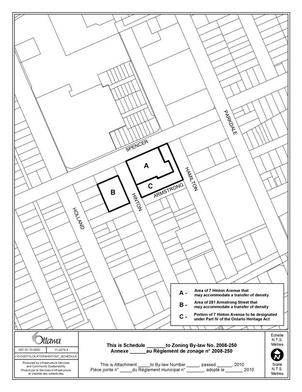
LOCATION
MAP DOCUMENT
7