|
1.
OFFICIAL PLAN AMENDMENT - Modification du PLAN OFFICIEL - |
COMMITTEE
RECOMMENDATION
(This application is subject to the
provisions of Bill 51.)
That Council approve and adopt an
amendment to Schedule A - Rural Policy Plan of the Official Plan to change the
designation of part of 8213 (8171) Flewellyn Road from Sand and Gravel Resource Area to
General Rural, as detailed in Document 2.
RECOMMANDATION DU COMITÉ
(Cette application est
assujettie aux dispositions du Règlement 51.)
Que le Conseil approuve et adopte une modification
à l’annexe A, Plan des politiques en milieu rural, du Plan officiel, de manière
à faire passer la désignation d’une partie du 8213 (8171), chemin Flewellyn de zone de ressources de sable et de
gravier à zone rurale générale, tel qu’exposé en détail dans le document 2.
Documentation
1. Deputy City Manager’s Report,
Infrastructure Services and Community Sustainability, dated 12 May 2011
(ACS2011-ICS-PGM-0093).
2. Extract of Draft Minutes, 2 June 2011.
Report to/Rapport au :
Agriculture and Rural Affairs
Committee
Comité de l'agriculture et des
affaires rurales
12 May 2011 / le 12 mai 2011
Submitted by/Soumis
par : Nancy Schepers, Deputy City Manager
Directrice
municipale adjointe, Infrastructure Services and Community Sustainability, Services d'infrastructure et Viabilité des
collectivités
Contact
Person/Personne-ressource : Derrick Moodie, Manager/Gestionnaire, Development
Review-Rural Services/Examen des projets d'aménagement-Services ruraux,
Planning and Growth Management/Urbanisme et Gestion de la croissance
(613)
580-2424, 15134 Derrick.Moodie@ottawa.ca
|
SUBJECT: |
OFFICIAL PLAN AMENDMENT - 8213 (formerly 8171) Flewellyn Road (FILE
NO. D01-01-09-0009) |
|
|
|
|
OBJET : |
Modification du PLAN OFFICIEL - 8213 (anciennement 8171), chemin
flewellyn |
REPORT RECOMMENDATION
That the Agriculture and Rural Affairs
Committee recommend Council approve and adopt an amendment to Schedule A -
Rural Policy Plan of the Official Plan to change the designation of part of 8213 (8171) Flewellyn Road from
Sand and Gravel Resource Area to General Rural, as detailed in Document 2.
RECOMMANDATION DU
RAPPORT
Que le Comité de l’agriculture
et des affaires rurales recommande au Conseil d’approuver et d’adopter une modification à
l’annexe A, Plan des politiques en milieu rural, du Plan officiel, de manière à
faire passer la désignation d’une partie du 8213 (8171), chemin Flewellyn de
zone de ressources de sable et de gravier à zone rurale générale, tel qu’exposé en détail dans le
document 2.
BACKGROUND
The Official Plan Amendment would allow for the
creation of two residential subdivisions with a total of 77 rural estate lots
to be developed on 74 hectares of land.
The property has frontages on Flewellyn Road and Fernbank Road, and lies
east of Dwyer Hill Road.
There are
two concurrent applications for subdivision associated with the amendment. The first phase of the subdivision would be
off of Flewellyn Road and would consist of 40 lots with five streets. Phase 2 would connect to the north side of
Phase 1 and extend out to Fernbank Road.
It would have 37 lots and three streets.
The
subject applications were filed on December 9, 2009 within the Council approved
‘grandparenting’ provisions for the implementation of the Moratorium on Country
Lot Development policy that was introduced as part of Official Plan Amendment
76 and therefore are being processed under the policies of the 2003 Official
Plan.
The Application
Official Plan
The
subject property is designated General Rural, Rural Natural Feature and Sand
Gravel Resource. All of the first phase
of the development is designated General Rural and Rural Natural Feature and
lies partially within the 300 metres of the Sand and Gravel Resource Area. The Phase 2 portion of the subdivision is
designated Sand and Gravel Resource and General Rural.
Requested Official Plan Amendment
The amendment requested would redesignate the
Sand and Gravel Resource Area to General Rural and give relief from the 500-metre
buffer required for sensitive uses adjacent to Limestone Resource Areas. The
Official Plan Amendment has been filed to address the proximity of 25 of the 37
proposed residential lots within Phase 2 of the development to the Limestone
Resource that exists to the west of Dwyer Hill Road. During the review process it was also suggested
and supported by the Ministry of Natural Resources that the Sand and Gravel
Resource designation on site be amended to General Rural.
DISCUSSION
Rationale
Section 2 of the Planning Act
requires municipalities to consider matters of provincial interest as expressed
through the 2005 Provincial Policy Statement. The policies in the Provincial
Policy Statement have been reflected in the City’s Official Plan.
Limestone Resource Area
The Provincial Policy Statement for
Mineral Aggregate Resources is intended to protect the resource for
long-term use. Incompatible development
near a resource area that could hinder or preclude the extraction of the
limestone would only be permitted if the extraction of the resource is not
feasible or the proposed land use or the proposed
development serves a greater long-term public interest; and issues of public
health, public safety and environmental impact are addressed. The City’s Official Plan has designated
Limestone Resources Resource Areas to protect the resource. The Official Plan also defines ‘adjacent’ as
lands within 500 metres to a Limestone Resource Area. The Official Plan does not contemplate allowing development of
conflicting uses within those adjacent areas, if there is not an active pit or quarry
licence. With a licensed pit or quarry
the parameters of extraction, dewatering, truck routes, blasting, and noise
impacts and so on are defined through the quarry licence and any permit to take
water. There is no licence on the lands designated Limestone Resource Area and
as such the applicant sought an amendment to allow for the development to be
contemplated within the lands adjacent to the Limestone Resource Area.
The Limestone Resource Area designation follows the centreline of Dwyer
Hill Road approximately 325 metres from the westerly lot line of the
development. Industry standards - including the regulations for a quarry -
require at least a 30-metre buffer or setback from the road. This would bring the actual quarrying
operation no closer than about 370 metres from the proposed residential lots
and would effectively remove nine of the proposed lots within Phase 2 of the
development from the lands adjacent to the Limestone Resource Area. The viability of extraction of the resource
is a concern given that it abuts a Provincially Significant Wetland, Manion
Corners (Long Swamp), and any change to surface water or dewatering of a quarry
could impact the wetland. Both of
the resources are at a similar elevation and any application for extraction
would have to demonstrate that the surface and ground water of the wetland
would not be impacted by the extraction and related dewatering. Another constraint to extraction near Dwyer
Hill Road is that the designated resource narrows to about 130 metres of
extraction area, once the quarry buffer and wetland buffer minimums are
implemented. There are a few existing
homes in proximity to the Limestone Resource Area that would hinder and
preclude some of the potential extraction.
In this instance, the
applicant has filed reports to demonstrate that should a quarry open in the
nearby Limestone Resource Area and be approved with the minimum industry
regulations, standards and best management practices, the potential for the
proposed adjacent subdivision to restrict the ability to quarry the resource
would be minimal. The studies identify
that with certain provisions within the subdivisions approvals, the impact of a
potential quarry on the proposed residents would also be minimal and could be
overcome.
Mineral Impact Assessment
The Official Plan contemplates allowing
incompatible or sensitive development within adjacent lands of a Limestone
Resource Area if there is an existing licensed quarry and subject to a Mineral
Impact Assessment being accepted by the Ministry of Natural Resources and the
City. The operational details and extent
of the operation of a licensed quarry are clearly defined within the Ministry
of Natural Resources licence and any Ministry of the Environment Permit to Take
Water, thereby allowing for the impacts on adjacent uses to be assessed based
on existing conditions.
As part of the applications for subdivision and
Official Plan Amendment, a Mineral Impact Assessment was filed with supporting
studies to assess the potential impact of a quarry being proposed in the
adjacent Limestone Resource Area. These
supporting studies include: Level 1 Hydrogeological Assessment, Blasting Impact
Assessment, and Quarry Noise. The studies reviewed the distances involved, the
best management practices and the regulations for quarry operations. It
concluded that with residential development on the subject lands there would be
a potential hindrance to a prospective quarry but it would not preclude the
quarry operation from establishing in proximity of the residential subdivision
and that the residential development would not be impacted by a quarry provided
some additional measures for protection were entrenched through the development
of the subdivision. The impediments were
identified as noise associated with the trucks, loaders, drills and processing
plants within the potential quarry that would exceed, by five decibels, the
Ministry of the Environment and the Official Plan’s daytime limit of 50
decibels to a stationary receptor (house).
Some additional berming of one to three metres over and above the
requirement to protect the existing houses was recommended by the report to be
imposed on a quarry as a result of these subdivisions. The study concludes that this hindrance from
the subdivision can be alleviated further by covenants on title and building
envelope restrictions. The assessment is
theoretical and based on assumptions of the details of the operation and
licence. It also assumes that the quarry
operator will bear the burden of the buffering and prevention of the potential
impacts of the use on the future residents.
The study included an assessment of the potential: blasting, residential
setbacks, truck traffic, noise attenuation, landscape and buffer strips. The Provincial Policy Statement and Official
Plan seek to protect the resource for future extraction, not protect the
incompatible use. Therefore, it would
seem prudent to implement the buffering and protection through the subdivision
process. To achieve that, setbacks to
the rear lot line for buildings and amenity areas should be maximized. The Ministry of Natural
Resources in their review concurred with the conclusion that a more proactive
approach be taken to ensure the privacy and protection of future residents and
reduce the potential hindrance of the residential use on a future quarry
operation. The measures suggested
include berms, landscape strips, setbacks for buildings, construction
techniques and covenants on title. Given that the height of land lies primarily to
the west of the subdivision site on the adjacent property and the existing
trees along the rear of the future residential lots, berming on the residential
subdivision side to mitigate the impacts of a potential quarry would have
limited effectiveness. As a condition of
subdivision approval an assessment of the potential for berming or other
measures to alleviate the potential noise constraint will be required and where
feasible will need to be implemented. Additionally, to ensure visual, dust and
noise mitigation, a 50-metre setback for buildings from the westerly lot line
will be implemented through the subdivision and zoning process. A 20-metre landscape strip - to be
implemented through the subdivision approval - could allow for larger trees to
be planted and thrive without being impacted by uses associated with a
residence. Covenants on title relating
to the proximity of the Limestone Resource Area would also be a requirement of
subdivision approval. The Official Plan
contemplates the imposition of conditions on development in proximity to a Limestone
Resource Area to mitigate impacts.
Built Form Context
There are three existing houses within 500
metres of the Limestone Resource Area.
The proposal would see 25 new residential lots within Phase 2 of the
proposed subdivision under File D07-16-09-0027 that lie within 500 metres of
the Limestone Resource Area. All of the
lots are at least 0.8 hectares in size and have adequate depth to accommodate a
50-metre rear yard setback to bring the available setback from the boundary of
the Limestone Resource Area to 370 metres to any building. In addition, the best management practises of
the Aggregate Resource Industry and the Aggregate Resources Act calls for any
quarrying operation to have on site setbacks, berms and screening of a minimum
30 metres. The total effect will be that
no new house within the subdivisions could be located within 420 metres of any
potential future quarrying operation.
Sand and
Gravel Resources
The north portion of
the subject site has an active sand and gravel pit licence issued by the
Ministry of Natural Resources. The resource designation overlaps a property
immediately to the east by a few metres.
The licensed pit lies solely within the Phase 2 portion of the
subdivision. The applicant contends that
the material extraction is nearly exhausted and that rehabilitation is
imminent. Any remaining materials within
the extraction area will be used for the subdivision either as fill for lots
and roads or to regrade to provide for safe slopes. The Ministry of Natural
Resources has agreed that the materials remaining are minimal and that the pit
could be rehabilitated through the approval of the subdivision. Essentially the pit rehabilitation plan will
be the municipally approved subdivision grading and drainage plan and landscape
plan. The uses adjacent to the area, to
be designated, are rural uses: including the proposed subdivision, agriculture
uses and rural residences.
The Provincial Policy
Statement speaks to allowing the rehabilitation works to accommodate the
subsequent land use in consideration of compatible adjacent uses. Section 3.7.4 of the Official Plan allows for
depleted resource sites to be considered for uses identified under the General
Rural Designation, which would include a residential subdivision. An Official Plan Amendment is not required to
permit those alternate uses once the resource is completely depleted.
Servicing
Servicing will be addressed in detail through
the subdivision approval process but will be on private wells and septic
systems. The Hydrogeologic and Terrain
Analysis Report has been filed and supports the proposed number and size of
lots on private services and recommends the private wells be drilled into the
lower bedrock aquifer (Nepean) which would not likely be impacted by quarrying
and dewatering of a the Limestone Resource Area.
Summary
An Official Plan Amendment to permit the
creation of the proposed residential lots within 325 metres of the Limestone
Resource Area is not required as it has been demonstrated that the proposed
development would not conflict with that resource area. Implementing setbacks and buffering through
the zoning and subdivision approvals processes will ensure that the residential
uses develop in a manner consistent with the Provincial Policy Statement and
the Official Plan. The proposed
residential lots will not preclude the creation of a quarry as has been
demonstrated through the Mineral Impact Assessment that any potential to hinder
a future quarry is limited to noise and is resolvable through the
implementation of notices, setbacks, and buffering through the subdivision
process. Through the Official Plan policies we can implement those development
requirements on the subdivision to ensure the potential hindrance to a future
quarry is eliminated and thus the residential subdivision would not conflict
with the potential adjacent quarry. On
that basis, a site specific Official Plan Amendment is therefore not required
to permit the subdivisions adjacent to a Limestone Resource Area.
The redesignation of the Sand and Gravel
Resource Area to General Rural reflects that the resource is nearly exhausted
and the site is to be rehabilitated, to permit General Rural uses. The recommended Official Plan Amendment
enables the first phase of the development to proceed while making use of the
limited resource found in the second phase.
RURAL IMPLICATIONS
The redesignation of the Sand and Gravel
Resource Area to General Rural will clarify the intended use of the site. The creation of residential lots 325 metres
from a Limestone Resource Area will require some mitigation for both the
potential future quarry and the residential use.
CONSULTATION
Notice of this application was carried out in
accordance with the City's Public Notification and Consultation Policy. The City did not receive any negative
comments or opposition to this application.
Detailed responses to the
notification/circulation are provided in Document 3.
COMMENTS BY THE WARD
COUNCILLOR(S)
The Ward Councillor has indicated support for
the Official Plan Amendment.
LEGAL IMPLICATIONS:
There are
no legal implications associated with this report.
RISK MANAGEMENT
IMPLICATIONS:
There are
no risk management implications associated with this report.
FINANCIAL IMPLICATIONS
There are no direct financial implications
associated with this report.
ENVIRONMENTAL IMPLICATIONS
There are no anticipated environmental impacts
from the Official Plan Amendment.
TECHNOLOGY IMPLICATIONS
N/A
CITY STRATEGIC PLAN
The staff recommendations support the managing of growth
and create sustainable communities by ensuring that new growth is integrated
seamlessly with established
communities.
APPLICATION PROCESS TIMELINE STATUS
This application was not processed by the
"On Time Decision Date" established for the processing of Official
Plan amendments due to the complexity of the issues associated with the
proposal.
SUPPORTING DOCUMENTATION
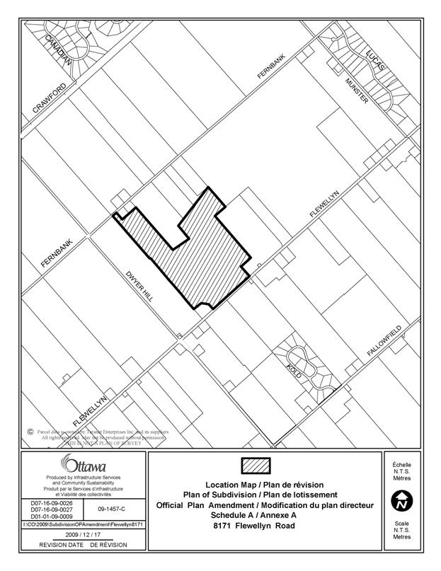
Document 1 Location
Map
Document 2 Proposed
Official Plan Amendment
Document 3 Consultation
Details
DISPOSITION
City Clerk and Solicitor Department,
Legislative Services to notify the owner, applicant, OttawaScene.com,
174 Colonnade Road, Unit #33, Ottawa, ON K2E 7J5, Ghislain Lamarche, Program
Manager, Assessment, Financial Services Branch (Mail Code: 26-76) of City Council’s decision.
Planning and Growth Management to prepare the by-law
adopting the Official Plan Amendment, forward to Legal Services, and undertake
the statutory notification.
Legal Services to forward the implementing
by-law to City Council
LOCATION MAP DOCUMENT
1
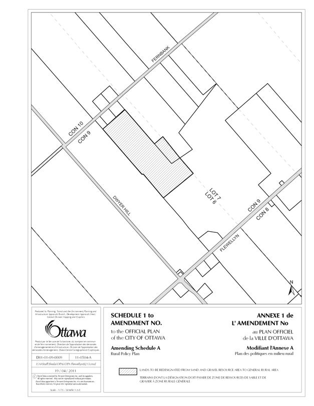
DOCUMENT 2
PROPOSED OFFICIAL PLAN AMENDMENT
Official Plan
Amendment XX to the
Official Plan for the
City of Ottawa
(Rev.
June 17,2011)
INDEX
THE STATEMENT OF
COMPONENTS
PART A - THE PREAMBLE
Purpose
Location
Basis
PART B - THE AMENDMENT
Introduction
Details of the Amendment
Implementation and Interpretation
Schedule A of Amendment XX - Official Plan
for the City of Ottawa
PART A -
THE PREAMBLE
PART A - THE PREAMBLE
introduces the actual amendment but does not constitute part of Amendment No. XX to the Official Plan for the City of Ottawa.
1.
Purpose
The Official Plan Amendment has been
filed to redesignate the Sand and Gravel Resource on site to General Rural.
2.
Location
8231 (formerly known as 8171)
Flewellyn Road is located north of Flewellyn Road and south of Fernbank Road in
the east half of Lot 6, Concession 9 Goulbourn.
Schedule A- Rural Policy Plan of the Official Plan will be amended for
part of Lot 6, Concession 9 Goulbourn to redesignate the Sand and Gravel
Resource Area to General Rural Area.
3.
Basis
3.1 Background
Section 2 of the Planning Act requires municipalities to have regard for matters of
provincial interest when carrying out their responsibilities under the
Act. Matters of provincial interest that
are relevant to this amendment are the conservation and management of natural
resources and the mineral resource base, the orderly development of safe and
healthy communities and the protection of public health and safety.
Section 3(5) of the Planning Act requires that the decision of a municipal council
shall be consistent with the policies in the Provincial Policy Statement (PPS),
a document that provides further detail regarding matters of provincial
interest. Section 2.5 of the PPS speaks to the provincial interest in Mineral
Aggregate Resources which includes both limestone and sand and gravel
deposits. The Provincial Policy
Statement speaks to allowing the rehabilitation works to accommodate the
subsequent land use in consideration of compatible adjacent uses.
The
property subject to the Official Plan Amendment contains a Sand and Gravel
Resource designation that has an active pit licence for it.
The
concurrent applications for subdivision contemplate a total of 77 country
residential lots to develop on a total of about 74 hectares, with frontages on
Flewellyn and Fernbank Roads, east of Dwyer Hill Road. The first phase of the
subdivision would be off of Flewellyn Road and would consist of 40 lots with
five streets. Phase 2 would connect to the north side of Phase 1 and extend out
to Fernbank Road. It would have 37 lots
and three streets. The Sand and Gravel
Resource designation lies within the Phase 2 subdivision.
3.2 Rationale
Sand and Gravel Resource
Section 3.7.4 of the Official Plan allows for
depleted resource sites to be considered for uses identified in the General
Rural Designation, which would include a residential subdivision. As part of
the review of the subdivision and official plan amendment applications it was
noted that amending the Sand and Gravel designations to General Rural would be
appropriate given that the resource is near to being exhausted on the
site. A resource that has been exhausted
does not require an Official Plan Amendment to permit alternate uses. However, by recognizing that the pit is
nearly depleted and will be rehabilitated it will clarify the intended land use
for the site and alleviate the concerns with respect to the adjacent
lands. The application for Official Plan
amendment was subsequently amended to request the designation of the Sand and
Gravel Resource to General Rural. The
Ministry of Natural Resources has agreed that the materials remaining are
minimal and that the pit could be rehabilitated through the approval process of
the subdivision.
PART B -
THE AMENDMENT
1. Introduction
All of this part of this document entitled Part B - The
Amendment consisting of the following text and
the attached Schedule A constitutes Amendment
No. XX to the Official Plan for the
City of Ottawa.
2. Details
The following changes are hereby made to the Official Plan for
the City of Ottawa:
2.1. Change the designation in Schedule A - Rural Policy Plan of the
Official Plan for part of the east half Lot 6 Concession 9, Goulbourn from Sand
and Gravel Resource Area to General Rural Area as shown on Schedule A to this
amendment.
3.
Implementation and Interpretation
Implementation and interpretation of this Amendment shall be in
accordance with the policies of the Official Plan for the City of Ottawa.
SCHEDULE A
CONSULTATION DETAILS DOCUMENT
3
A Public Meeting for the two related plans of
subdivision was held on February 17, 2011 at the Goulbourn Recreation Complex. Approximately 12 members of the public were
in attendance eight of whom signed the sign in sheet. The meeting also was used
a as Community Information and Comment Session for the proposed Official Plan
Amendment.
The
concerns expressed at the meeting were the same as those filed with the City
and are responded to below:
1)
The Planning Rationale indicated the licensed sand and gravel pit would
be rehabilitated and it was questioned how that was being proposed.
It was noted that the licence has a rehabilitation plan that is minimal
and that Ministry of Natural Resources, in cases such as this, will accept a
for example subdivision grading and drainage plan in lieu of the former
rehabilitation plan. But basically it
will involve sloping down any escarpment areas and making it safe.
2)
The existing and proposed drainage pattern was questioned along with
concerns with increased run-off causing flooding and road washouts as in a
previous summer storm.
It was noted that the onsite that drainage is split yard with runoff
running from the house to the rear and to the front of each lot. There it is captured in swales and directed
to road side ditches. The drainage for
the development itself is also split with some running south to Flewellyn and
some running to the east. All drainage
will have to have a legal outlet existing or provided as part of the approval. As well the run-off from the development in
the normal course of events as well as storm events cannot exceed the current
run-off in those circumstances.
3)
From where and how much fill will be needed to cover the shallow
bedrock?
The amount of fill will depend on the detailed road design, grading and
drainage for the site. As much as
possible will be used from excavations on site eg. Phase 1 development will move the excavated
fill to phase 2 for use.
4)
It was noted by the public that much of phase 1 is also shallow bedrock.
This will be assessed in detail during the final approval process.
5)
Concern was expressed over the increase potential runoff and damage
downstream and correction of the concern as has happened with heritage and
Heron lakes subdivisions. They were
built about 20 years ago.
It was noted that stormwater management 20 years ago often only required
positive drainage from a development and did not look to upstream and
downstream impacts as much. Now a
development cannot increase or decrease flows through out of their development.
6)
The direction of groundwater flow was questioned as was the quality and
depth.
The groundwater flows from the north toward Munster and in fact this
site lies within the wellhead protection area of the Munster well. The Mississippi Rideau Source Water
Protection website provides details with respect to groundwater in this area.
The wells were dug to the Nepean aquifer and the water was generally found to
be good without the sulphur issues found in other wells locally.
7)
Concern was expressed over the fractured rock noted in the report and a
guarantee that they will not lose good water quality and quantity.
The Hydrogeologic Report indicates no well interference during
testing. It also recommends minimum
standards for depth of well and casing through and beyond the fractured rock as
well as backfilling material around the well.
Those requirements would be registered on title as at minimum within the
subdivision agreement and possibly as covenants on title.
8)
A resident on Fernbank noted that when the City did some ditch and culvert
work his 50 foot well went dry.
Staff indicated that if residents had concerns about surface drainage
and grading changes and the impact on shallow wells to let staff know and we
will look at the reports again to confirm the findings.
9)
The impact on ground water from the potential quarry to the west was
questioned.
It was noted that the wells are to extend into the Nepean Aquifer and
the quarry would not go that deep.
10)
It was noted that there is natural artesian along the lot line in the
vicinity of the pit.
This will be looked into
11)
It was asked if the old quarry would be filled in.
It is proposed to leave it open as part of a private lot.
12)
The Planning Rationale’s comment that a neighbouring property was not used
for agriculture was questioned, as well as the owner’s ability to continue or
expand a farm operation.
It was recognized that this was an error and should have read that the
land was not used as a livestock facility
The barns/building on site did not meet the OMAF tests as livestock
facility therefore the minimum distance separation (MDS) to the lots was not
required. Alternatively if the owner was
proposing to put in a livestock facility he would have to demonstrate as part
of any building permit that he would have to meet MDS.
It was also noted that nothing was prohibiting the continued use of the
land for agricultural purposes including manure spreading. But it was suggested that best management
practices would still be advisable as would a good neighbour policy of letting
them know when the spreading would happen.
13)
It was asked if the snowmobile trail running along the south and west
edge of the development was being addressed or accommodated.
It was noted that the local snowmobile club had been in touch with staff
but there was yet to be any detailed discussion.
14)
Noise concerns were noted for future homeowners with respect to the
Ottawa Airport flight lines and the nearby military facility.
It was noted that it is outside of the regulated influence are of the
airport and that the military facility was some distance away.
15)
It was asked why there was a wider road or block off of Fernbank.
The reason for the space relates to the width of the frontage only and
that the block would be left in trees with perhaps some subdivision signage.
16)
Concern was expressed over the ‘blind hill’ access from Phase one out to
Flewellyn.
This was looked into and determined that any issues could be addressed
with the road works at the time of the construction.
17)
Concern was expressed over the state of the Fernbank Road, with the
pavement broken up even though it was newer.
This is a matter for City maintenance and not within the realm of the developer’s
responsibility.
COMMUNITY ORGANIZATION COMMENTS
Members
of the North Goulbourn Community Association attended the February meeting. No
written comments were received.