4. ZONING – 6048-6060 Renaud Road
ZONAGE – 6048-6060, chemin
renaud
COMMITTEE
RECOMMENDATION
(This matter is
Subject to Bill 51)
That Council
approve an amendment to the Zoning By-law 2008-250 to change the zoning of
6048-6060 Renaud Road from DR – Development Reserve to R3VV[xxxx] - Residential
Third Density Subzone VV exception xxxx, and O1 - Parks and Open Space Zone as
shown in Document 1 and as detailed in Document 2.
RECOMMANDATION DU COMITÉ
(Cette question est assujettie au Règlement 51)
Que le Conseil approuve une modification au
Règlement de zonage 2008-250 en vue de faire passer le zonage du 6048-6060,
chemin Renaud de DR – Zone d’aménagement futur à R3VV[xxxx] – Sous-zone
résidentielle de densité 3 VV, exception xxxx, à O1 – Zone de parc et d’espace
vert, tel qu’illustré dans le document 1 et exposé en détail dans le document
2.
Documentation
1.
Deputy
City Manager's report, Infrastructure
Services and Community Sustainability, dated 22 June 2011 (ACS2011-ICS-PGM-0119).
Report to/Rapport au :
Comité de l'urbanisme
and Council / et au Conseil
22 June 2011 / le 22 juin 2011
Submitted by/Soumis par :
Nancy Schepers, Deputy City Manager/Directrice
municipale adjointe, Infrastructure Services
and Community Sustainability/Services d’infrastructure et Viabilité des
collectivités
Contact
Person/Personne-ressource : Derrick Moodie, Acting Manager/Gestionnaire
intérimaire, Development Review-Suburban Services/Examen des projets d'aménagement-Services
suburbains, Planning and Growth Management/Urbanisme et Gestion de la
croissance
(613)
580-2424, 15134 Derrick.Moodie@ottawa.ca
|
SUBJECT: |
|
|
|
|
|
OBJET : |
REPORT RECOMMENDATIONS
That the recommend Council approve an amendment to the
Zoning By-law 2008-250 to change the zoning of 6048-6060 Renaud Road from DR –
Development Reserve to R3VV[xxxx] - Residential Third Density Subzone VV
exception xxxx, and O1 - Parks and Open Space Zone as shown in Document 1 and
as detailed in Document 2.
RECOMMANDATIONS
DU RAPPORT
Que le Comité de l’urbanisme recommande au Conseil d’approuver une modification au
Règlement de zonage 2008-250 en vue de faire passer le zonage du 6048-6060,
chemin Renaud de DR – Zone d’aménagement futur à R3VV[xxxx] – Sous-zone
résidentielle de densité 3 VV, exception xxxx, à O1 – Zone de parc et d’espace
vert, tel qu’illustré dans le document 1 et exposé en détail dans le document
2.
BACKGROUND
The subject property is located to the south of Renaud Road between Joshua Street and Saddleridge Drive in the East Urban Community. The property is a narrow strip of vacant land of approximately 5.2 hectares, which was not included in the Spring Valley Trails Subdivision to the east and west. The Spring Valley Trails Subdivision was registered with two streets crossing the subject properties. One of these streets, Felicity Crescent, has been constructed.
Purpose of Zoning Amendment
The proposed Zoning By-law amendment is required to allow development of a fully serviced residential subdivision in the East Urban Community consisting of 89 on-street townhouses and 32 single detached homes.
Existing Zoning
The existing zoning of the property is DR, Development Reserve which recognizes lands that are intended for future urban development.
Proposed Zoning
The proposed zoning is R3VV[xxxx] - Residential Third Density Subzone VV
exception xxxx and O1– Parks and Open Space Zone. This will permit an urban residential
development of single family dwellings, on street townhouses and parkland.
DISCUSSION
Provincial Policy Statement
The Provincial Policy Statement (PPS) provides direction on matters of Provincial Interest related to land-use planning and development by promoting efficient land use patterns that support development of viable liveable communities. Contained within the policy statement are explicit policy objective that focus on growth in settlement areas, providing an appropriate range of housing with densities that efficiently use land resources (infrastructure and public service facilities), promoting public transit and other alternative transportation modes and creating healthy and active communities.
The proposed development is consistent with the objective and policies of the PPS and provides new residential development that makes efficient use of available and projected infrastructure services.
Official Plan
The Official Plan designates the
properties as General Urban with a Developing Community overlay. This designation permits the development of a
full range and choice of housing types to meet the needs of all, in combination
with conveniently located related uses such as leisure, retail, service and
institutional uses. The Developing Community overlay requires the completion of
a community design plan prior to any development being approved. The East Urban Community (Phase 1) Community
Design Plan (CDP) was approved July 2005.
The East Urban Community (Phase 1)
CDP designates the subdivision lands as Residential, Environmental Hazard Land
and Parks.
The subdivision application for 6048-6060
Renaud Road (D07-16-11-0002) has yet to receive Draft Approval.
The proposed development meets
density targets contained in the Official Plan and CDP for this land.
Details of Proposed Zoning
The applicant is requesting that the zoning for 6048-6060 Renaud Road be changed to R3VV[xxxx] and O1 in advance of draft plan approval of the subdivision.
The VV subzone establishes design elements that allow compact built form. The purpose is to permit different development standards primarily for areas designated as Developing Communities to promote efficient land use. This design control brings the main entries to the houses closer to the street, and facilitates a more aesthetic streetscape.
Notwithstanding this, the exception [xxxx] requires the buildings to be set back from the street line by 5.5 metres to allow sufficient space for street trees.
The partial park block is to be zoned O1 as shown in Document 2. This Parks and Open Space zone will permit a local park of 0.5 hectares.
Staff are satisfied that the proposed changes in the zoning of 6048-6060 Renaud Road to R3VV[xxxx] and O1, is consistent with the policies of the Provincial Policy Statement, the Official Plan and the East Urban Community CDP and recommend approval.
ENVIRONMENTAL IMPLICATIONS
The plans identified a park block next to an existing park block on the abutting subdivision. The park location is central to all residents in the immediate neighbourhood with improved accessibility. The consolidated park blocks will be developed as an active park.
Rideau Valley Conservation (RVC) has reviewed the proposed zoning amendment in the context of the related plan of subdivision. RVC comments have been incorporated as part of the subdivision review, and the zoning is to be consistent with the draft approved Plan of Subdivision and the East Urban Community CDP.
RURAL IMPLICATIONS
N/A
CONSULTATION
Notice of this application was carried out in accordance with the City's Public Notification and Consultation Policy. The City received two comments concerning increased traffic flow in the Navan Area due to the development of these lands. Traffic matters are being reviewed as part of the subdivision process for 6048-6060 Renaud Road.
COMMENTS BY THE WARD COUNCILLOR(S)
The Ward Councillor is aware of this application and staff’s recommendation.
LEGAL IMPLICATIONS
There are no legal implications associated with this report.
RISK MANAGEMENT IMPLICATIONS
N/A
CITY STRATEGIC PLAN
Manage growth and create sustainable communities by:
· becoming leading edge in community and urban design
· ensuring that new growth is integrated seamlessly with established communities
· ensuring that community facilities are built in tandem with new development.
Ensure that the City infrastructure required for new growth is built or improve as need to serve growth.
TECHNICAL IMPLICATIONS
FINANCIAL IMPLICATIONS
There are no direct financial implications associated with this report.
APPLICATION PROCESS TIMELINE STATUS
This application was not processed by the "On Time Decision Date" established for the processing of Zoning By-law amendment applications due to complications relating to the size of the park.
SUPPORTING DOCUMENTATION
Document 1 Location Map
Document 2 Details of Recommended Zoning
DISPOSITION
City Clerk and Solicitor Department, Legislative Services to notify the owner, applicant, OttawaScene.com, 174 Colonnade Road, Unit #33, Ottawa, ON K2E 7J5, Ghislain Lamarche, Program Manager, Assessment, Financial Services Branch (Mail Code: 26-76) of City Council’s decision.
Planning and Growth Management to prepare the implementing by-law, forward to Legal Services and undertake the statutory notification.
Legal Services to forward the implementing by-law to City Council.
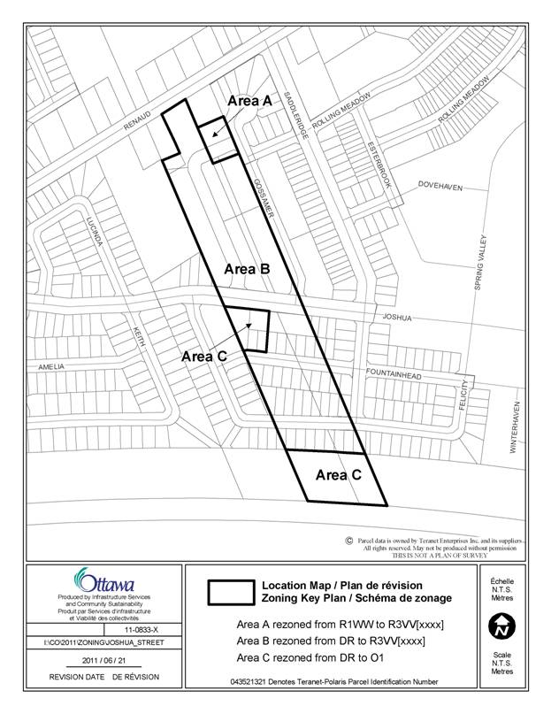
LOCATION MAP DOCUMENT
1
DETAILS OF RECOMMENDED ZONING DOCUMENT
2
Proposed
Changes to the Comprehensive Zoning By-law
- The
subject lands shown on Document 1 will be rezoned as follows:
a) Area A from R1WW to
R3VV[xxxx]
b) Area B from DR to
R3VV[xxxx],
c) Area C from DR to
O1.
2. Add
a new exception to Section 239 with text similar in effect to the following:
a)
in
Column II the text "R3VV[xxxx],
b)
minimum
of 5.5 m front yard setback
c)
minimum net
density is 27 dwelling units per hectare
d)
maximum net
density is 60 dwelling units per hectare