4. ZONING – Part of 5431 and Part
of 5465 Fernbank Road
ZONAGE – Partie du 5431 et partie du 5465, chemin
Fernbank
COMMITTEE RECOMMENDATIONS AS AMENDED
(This matter is
Subject to Bill 51)
1.
That Council approve an amendment to Zoning
By-law 2008-250 to change the zoning of Part of 5431 and Part of 5465 Fernbank
Road to Residential First Density Subzone Z exception [XXXX] - R1Z[XXXX],
Residential Third Density Subzone Z exception [XXXY] - R3Z[XXXY], Residential
Fourth Density Subzone Z - R4Z, and Open Space - O1 as shown in Document 1 and
as detailed in Document 2.
2.
That
Document 2 be replaced with the following:
DETAILS OF RECOMMENDED ZONING DOCUMENT 2
1)
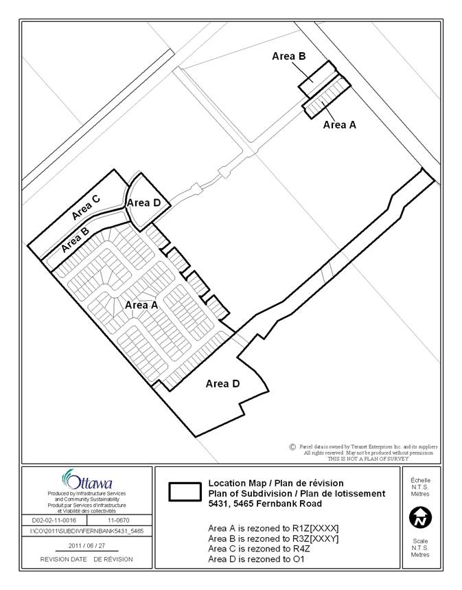
Rezone the subject properties as shown in Document 1
such that:
a.
Area A is rezoned to R1Z[XXXX];
b.
Area B is rezoned to R3Z[XXXY];
c.
Area C is rezoned to R4Z; and,
d.
Area D is rezoned to O1.
2)
Amend Section 239 – Exceptions of By-law 2008-250 to
create an exception, [XXXX], for Area A as shown in Document 1, that includes
in effect the following:
“In Column V
- minimum front yard
setback: 5m
-
maximum distance the front wall of a private
garage attached to a detached dwelling may extend beyond the building front
wall, building sidewall, covered porch or veranda: 2.7m
-
maximum building height for lots with a minimum
lot width of 14.05 metres is 12 metres.
3)
Amend Section 239 – Exceptions of By-law 2008-250 to
create an exception, [XXXY], for Area B as shown in Document 1, that includes
in effect the following:
“In Column V
- minimum
front yard setback: 5m
-
maximum distance the front wall of a private
garage attached to a multiple attached dwelling may extend beyond the building
front wall, building sidewall, covered porch or veranda: 2.7m.”
3.
That Document 1 be replaced with the attached Location Map.
RECOMMENDATIONS MODIFÉES DU COMITÉ
(Cette question est assujettie au Règlement
51)
1.
Que le u Conseil approuve une modification au Règlement de zonage no 2008-250
afin de changer la désignation de zonage d’une partie du 5431 et d’une partie
du 5465, chemin Fernbank, à R1Z[XXXX] (zone résidentielle de densité 1, sous‑zone Z,
assortie de l’exception [XXXX]), à R3Z[XXXY] (zone résidentielle de densité 3,
sous‑zone Z, assortie de l’exception [XXXY]), à R4Z (zone résidentielle
de densité 4, sous‑zone Z), et à zone de parc et d’espace vert
O1 tel qu’il est montré dans le document 1 et indiqué dans le
document 2. »
2.
Que le document 2 soit remplacé par
le document suivant :
DÉTAILS DU
ZONAGE RECOMMANDÉ DOCUMENT 2
1)
Procéder a la modification du zonage des propriétés concernées tel qu’il
est indiqué dans le document 1, de manière à ce que :
a.
le zonage du secteur A soit modifié pour R1Z[XXXX];
b.
Le zonage du secteur B soit modifié pour R3Z[XXXY];
c.
Le zonage du secteur C soit modifié pour R4Z;
d.
Le zonage du secteur D soit modifié pour O1.
2)
Modifier l’article 239 – Exceptions du règlement municipal no 2008-250
afin de créer une exception, [XXXX], pour le secteur A tel qu’il est indiqué
dans le Document 1, comprenant concrètement ce qui suit :
« à la colonne V
– retrait
minimal de la cour avant : 5 m
-
distance maximale à laquelle le mur avant d’un garage privé annexé à une
habitation isolée peut être prolongé au-delà du mur avant du bâtiment, du mur
latéral, d’un porche couvert ou d’une véranda : 2,7 m. »
3)
Modifier l’article 239 – Exceptions du règlement municipal no 2008-250
afin de créer une exception, [XXXY], pour le secteur B tel qu’il est indiqué
dans le Document 1, comprenant concrètement ce qui suit :
« à la colonne V
– retrait minimal de la cour
avant : 5 m
-
distance maximale à laquelle le mur avant d’un garage privé annexé à une
habitation multifamiliale contiguë peut être prolongé au-delà du mur avant du
bâtiment, du mur latéral, d’un porche couvert ou d’une véranda :
2,7 m. »
3. Que le document 1 sera remplacé par
la carte de localisation ci‑jointe.
Documentation
1.
Deputy
City Manager's report, Infrastructure
Services and Community Sustainability, dated 8 June 2011 (ACS2011-ICS-PGM-0132).
2
Extract
of Planning Committee Minutes of 28 June 2011.
3. Revised Location Map, as referenced in the
amended recommendation.
Report to/Rapport au :
Comité
de l'urbanisme
and Council / et au Conseil
08 June 2011 / le 08 juin 2011
Submitted by/Soumis par : Nancy
Schepers, Deputy City Manager/Directrice municipale adjointe, Infrastructure
Services and Community Sustainability/
Services d’infrastructure et Viabilité des collectivités
Contact
Person/Personne-ressource : Derrick Moodie, Acting Manager/Gestionnaire
intérimaire, Development Review-Suburban Services/Examen des projets
d'aménagement-Services suburbains, Planning and Growth Management/Urbanisme et
Gestion de la croissance
(613) 580-2424,
15134 Derrick.Moodie@ottawa.ca
|
SUBJECT: |
ZONING – Part of 5431 and Part of 5465 Fernbank Road (FILE NO. D02-02-11-0016) |
|
OBJET : |
REPORT RECOMMENDATIONS
That the recommend Council:
1.
Approve an amendment to Zoning By-law 2008-250
to change the zoning of Part of 5431
and Part of 5465 Fernbank Road to Residential
First Density Subzone Z exception [XXXX] with a 12 metre height limit and a
holding symbol - R1Z[XXXX](H12)-h, Residential Third Density Subzone Z
exception [XXXX] with a 12 metre
height limit and a holding symbol - R3Z[XXXX](H12)-h, Residential Fourth Density Subzone Z exception [XXXZ] with a holding symbol -
R4Z[XXXZ]-h, and Open Space exception [XXXZ] with a holding symbol - O1[XXXZ]-h
as shown in Document 1 and as detailed in Document 2; and
2.
Delegate to the General Manager, Planning and
Growth Management, the authority to waive the planning fees, identified in the
Planning Fee By-law (2010-110), for ‘Lifting Holding By-law’ application
related to the subject ‘h’ and list the by-law for removal of the holding
symbol once the provisions in Document 2 are met.
RECOMMANDATIONS
DU RAPPORT
Que le Comité de l'urbanisme
recommande au Conseil :
1.
d'approuver une modification du Règlement municipal de zonage 2008‑250
afin de changer la désignation de zonage d'une partie du 5431 et d'une partie du 5465 du chemin Fernbank à R1Z[XXXX](H12)-h (Zone
résidentielle de densité 1, sous-zone Z,
assortie de l'exception [XXXX] avec limite de hauteur de 12 mètres et
affectée du symbole d'aménagement différé), à R3Z[XXXX](H12)-h (Zone résidentielle de densité 3, sous-zone Z, assortie de l'exception [XXXX] avec limite de
hauteur de 12 mètres et affectée du symbole d'aménagement différé), à
R4Z[XXXZ]-h (Zone résidentielle de densité 4, sous-zone Z, assortie de
l'exception [XXXZ] et affectée du symbole d'aménagement différé) et à
O1[XXXZ]-h (Zone de parc et d'espace vert, assortie de l'exception [XXXZ] et
affectée du symbole d'aménagement différé), tel qu'il est indiqué dans le
document 1 et décrit en détail dans le document 2;
2.
de déléguer au directeur général, Urbanisme et Gestion de la croissance,
le pouvoir de renoncer aux droits prévus dans le Règlement sur les droits de
demande d'aménagement (2010-110) relativement aux demandes assujetties au
Règlement sur la levée d'une disposition d'utilisation différée « h »
et de supprimer le symbole d'aménagement différé une fois que les dispositions prévues dans
le document 2 auront été respectées.
BACKGROUND
The subject property is within the Fernbank Community Design Plan lands as approved by Official Plan Amendment 77. The lands lie south of the Hydro Corridor and TransCanada Trail (Abbott Street extension), east of Shea Road and the future North South Arterial Road, west of Terry Fox Drive and north of Fernbank Road. The majority of the lands have been cultivated over the past number of years. The site contains some fence rows and a portion of the Monahan Drain. The rezoning will only apply to a portion of the applicant’s holdings within the Fernbank Community and specifically those lands subject to Plan of Subdivision application D07‑16‑10‑0008.
Purpose of Zoning Amendment
The rezoning would permit the proposed uses contemplated within the plan of subdivision. Specifically, it would zone for 203 singles, two blocks of freehold row dwellings or multiple attached dwellings and one block of condominium row dwellings, stacked dwellings or apartments. The park, open space and stormwater management blocks will also be zoned.
Existing Zoning
The current Development Reserve zone – DR recognizes that the area was included within Official Plan Amendment 77 as General Urban Area. By-law 2011-49 placed a holding symbol on the DR zone for these lands pending the completion of the Environmental Assessment and works associated with upgrading the capacity of the Hazeldean Pump Station. That by-law has been appealed to the Ontario Municipal Board.
The upgrades to the Hazeldean Pump Station include a Schedule B Environmental Assessment to permit a capacity beyond 1400 litres per second and the actual upgrades identified in the Schedule A+ Environmental Assessment works that bring the pump station capacity up to 1225 litres per second.
The Schedule B Environmental Assessment process and the Schedule A+ works need to be completed, before the holding symbol can be removed. To date, the Schedule B Environmental Assessment is complete and the Schedule A+ works are underway and are anticipated to be completed by the end of June.
Proposed Zoning
The proposed zoning would permit singles, street townhouses and walk-up apartments or stacked towns as well as the park, open space and stormwater blocks. The proposed zones include the holding symbol that reflects the one implemented through the appealed By-law 2010-49.
DISCUSSION
Official Plan and Fernbank Community Design Plan
The lands are designated in Schedule B of the Official Plan as General Urban, which contemplates a range of residential uses as well as park and open space uses.
The Fernbank Community Design Plan shows the subject lands as a mix of low and medium density residential uses. It also includes a park, open space and a stormwater management facility. The road layout, distribution of medium density residential blocks and the park block differ slightly from the Demonstration Plan within the Community Design Plan but meet the policies and intent of that plan.
Details of Proposed Zoning
The
rezoning would permit the proposed uses contemplated within the plan of
subdivision application. Specifically,
it would zone:
1)
The 203 single family dwelling
lots to a Residential First Density Subzone Z with a height limit of 12 metres with
an exception for a five metre front yard setback. The R1Z has a standard front
yard setback of three metres. An additional exception to allow for a 12 metre
height has also been requested.
2)
Block 204 and Block 209 would be
zoned for freehold street row dwellings or multiple attached. The zone would be similar to a Residential
Third Density Subzone Z exception 1677 - R3Z[1677] zone with an additional
exception. The front yard setbacks for
this zone would be a minimum of five metres not the three metres under the
current zoning. The exception 1677 also allows for the garage to be closer to
the street than the house by 2.7 metres.
An additional exception to allow for a 12 metre height has also been
requested.
3)
Block 207, is to be for condominium
stacked dwellings or low-rise apartments with a Residential Fourth Density
Subzone Z - R4Z zone.
4)
The park, open space and
stormwater management blocks will be zoned Open Space - O1.
5)
A holding symbol and provisions
for lifting the holding shall be the same as the current Zoning By-law
2010-049.
Analysis
Overall, the proposed zones meet the intent of the Official Plan and Community Design Plan with respect to the range of permitted residential uses and the open space uses.
The subject lands contain sensitive marine clays and the use of the standard three metre front yard setback would result in very few streetscape trees if the City’s tree planting policy is applied. This is not appropriate, so an exception to the front yard setback to a five metre minimum is necessary. This will allow for adequate room for the small trees contemplated within the City’s policy to be planted. This exception requested would apply to the zoning for the singles and street townhouses within the proposed plan of subdivision.
The applicant has also requested a height limit of 12 metres, which is one metre higher than the R1Z zone requirement for the singles and the R3Z zone requirement for street townhouses. This is a relatively minor change.
The requested exception zone for the street townhomes to allow the garage to be 2.7 metres closer to the street than the main part of the home has been requested to address one model type contemplated for this subdivision. There will still be a 6.2 metre setback requirement from a sidewalk to the front of the garage. This exception will still allow for parking in front of the garage of this one model type of 5.5 metres where there are no sidewalks in the right of way and 5.7 metres with sidewalks. That is in compliance with the Traffic and Parking By-law requirement of parking in a driveway being 0.5 metres from a sidewalk and 1.5 metres from a roadway.
Servicing Issues
Water and stormwater capacity are required to be extended and are to be provided by the applicant. This has been demonstrated to be possible through the conceptual servicing report and the draft plan of subdivision process.
Currently, there is not available capacity for sanitary servicing due to the limitations with the Hazeldean Pump Station. It is in the process of being upgraded to a 1225 litres per second capacity and the completed Schedule B Class Environmental Assessment will allow the capacity to further increase to above 1400 litres per second. Once the Schedule A+ works currently occurring are complete the pump station will then provide some capacity for sanitary services for the Fernbank lands. The completion of the Schedule B works within the next few years will create capacity for all development within the Hazeldean Pump Station’s sewershed. The zoning can be supported at this time but only with a holding symbol and provisions for lifting of that holding.
The zones include a holding symbol as it is anticipated that the zoning by-law would go forward to Council prior to the completion of the 1225 litres per second works. The timing of that completion is close. If the Hazeldean Pump Station works are completed as anticipated by the end of June then by the first Council in July the pump station Schedule A+ works would be complete and a holding symbol will not be required.
As requested with the previous holding zones for the Hazeldean Pump Station sewershed lands, the General Manager will have authority to lift the holding symbol in an efficient manner once the Schedule A works are complete.
Concurrent Application
There is a plan of subdivision under file D07-16-10-0008 that is in the process of being approved. The applicants have appealed the City’s lack of decision to the Ontario Municipal Board but have indicated they will be withdrawing the appeal upon concurrence to the conditions for draft approval. The anticipated timing of the draft plan approval mirrors the timing for this by-law proceeding forward to Council.
Summary
The zoning amendment complies with the intent of the Official Plan and Community Design Plan. The exception to the subzones requested will allow for trees in the streetscape of the subdivision and allow for some variety in building height in the singles and street townhouses and variety of model type for the street townhouses. Implementation of the holding symbol on the zones will ensure that the zoning is not premature.
RURAL IMPLICATIONS
N/A
CONSULTATION
Notice of this application was carried out in accordance with the City's Public Notification and Consultation Policy. The City did not receive any negative comments or opposition to this application.
COMMENTS BY THE WARD COUNCILLOR(S)
The Ward Councillor is aware of
the application and has offered no formal comment.
LEGAL IMPLICATIONS
There are no legal
implications associated with this report.
RISK MANAGEMENT IMPLICATIONS
N/A
FINANCIAL IMPLICATIONS
There are no direct financial implications associated
with this report.
ENVIRONMENTAL
IMPLICATIONS
The subject lands include what is now the Monahan Drain. The Fernbank Community Design Plan and the related subdivision plan for these lands contemplate the upper portion of the drain becoming the stormwater management pond to serve this and other lands with the drain itself to be reworked and naturalized subject to the approval of the City and Conservation Authority. The Environmental Impact Statement for the draft plan of subdivision has been accepted and the details will be addressed through the subdivision final approval.
TECHNOLOGY IMPLICATIONS
CITY STRATEGIC PLAN
The
rezoning will support the objectives within the City’s Strategic Plan by expanding
the amount of City-owned green space; managing growth and creating sustainable
communities by becoming leading edge in community and urban design, and
ensuring that the City infrastructure required for new growth is built or
improved as needed to serve growth.
APPLICATION PROCESS TIMELINE STATUS
This application was processed by the "On Time Decision Date" established for the processing of Zoning By-law amendment applications.
SUPPORTING DOCUMENTATION
Document 1 Location Map
Document 2 Details of Recommended Zoning
DISPOSITION
City Clerk and Solicitor Department, Legislative Services to notify the owner, applicant, OttawaScene.com, 174 Colonnade Road, Unit #33, Ottawa, ON K2E 7J5, Ghislain Lamarche, Program Manager, Assessment, Financial Services Branch (Mail Code: 26-76) of City Council’s decision.
Planning and Growth Management to prepare the implementing by-law, forward to Legal Services and undertake the statutory notification.
Legal Services to forward the implementing by-law to City Council.
LOCATION MAP DOCUMENT
1
DETAILS OF RECOMMENDED ZONING DOCUMENT 2
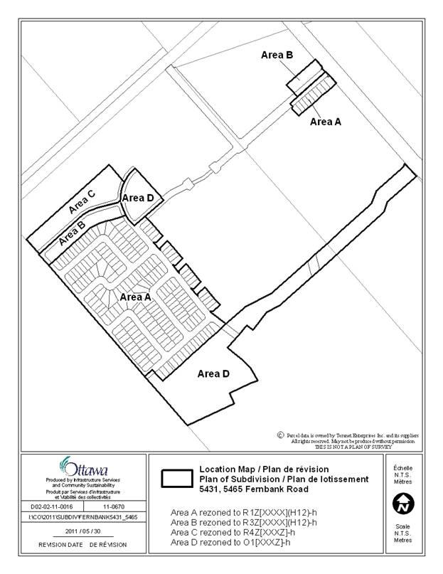
4) Rezone the subject properties as shown in Document 1 such that:
a. Area A is rezoned to R1Z[XXXX](H12)-h;
b. Area B is rezoned to R3Z[XXXX](H12)-h;
c. Area C is rezoned to R4Z[XXXZ]-h; and,
d. Area D is rezoned to O1[XXXZ]-h.
5) Amend Section 239 – Exceptions of By-law 2008-250 to create an exception, [XXXX], for Area A and B as shown in Document 1, that includes in effect the following:
In Column IV
“- all permitted uses, except:
a. Those uses that existed on July 13, 2011, or
b. Any use or development that does not result in increased sanitary flow to the Hazeldean Pump Station,
are prohibited until the holding symbol is removed.”
In Column V
- minimum front yard setback: 5m
- maximum distance the front wall of a private garage attached to a detached dwelling may extend beyond the building front wall, building sidewall, covered porch or veranda: 2.7m.”
“The holding symbol will not be removed until such time as:
a. the works to bring the capacity of the Hazeldean Pump Station to 1225 l/s are complete;
b. the Ministry of Environment has approved the Schedule B Environmental Assessment to bring the capacity of the Hazeldean Pump Station up to 1400 plus l/s.”
6) Amend Section 239 – Exceptions of By-law 2008-250 to create an exception, R4Z[XXXZ]-h for Area C and O1[XXXZ]-h, for Area D as shown in Document 1, that includes in effect the following:
In Column IV
“- all permitted uses, except:
a. Those uses that existed on July 13, 2011, or
b. Any use or development that does not result in increased sanitary flow to the Hazeldean Pump Station,
are prohibited until the holding symbol is removed.”
In Column V
“The holding symbol can be removed only at such time as:
a. the works to bring the capacity of the Hazeldean Pump Station to 1225 l/s are complete;
b. the Ministry of Environment has approved the Schedule B Environmental Assessment to bring the capacity of the Hazeldean Pump Station up to 1400 plus l/s; and,
c. it has been demonstrated to the satisfaction of the General Manager, Planning and Growth Management, that the Hazeldean Pump Station has the necessary capacity to permit development of the property.”