5. ZONING – Part of 3718 and Part of
3772 Greenbank Road
ZONAGE – partie du 3718 et du 3772, chemin greenbank
COMMITTEE
RECOMMENDATION
(This matter is
Subject to Bill 51)
That Council
approve an amendment to the Zoning By-law 2008-250 to change the zoning of Part
of 3718 and Part of 3772 Greenbank Road from DR (Development Reserve) to
R3YY[XXXX] Sxxx (Residential Third Density Subzone YY Exception XXXX, Schedule
xxx), I1A/R3YY[XXXX]Sxxx (Minor Institutional Subzone A/Residential Third
Density Subzone YY Exception XXXX Schedule xxx) and O1 (Parks and Open Space
Zone) to allow a residential subdivision, as shown in Documents 1 and 2 and as
detailed in Document 3.
RECOMMANDATION DU COMITÉ
(Cette question est assujettie au Règlement
51)
Que le Conseil
approuve une modification au Règlement de zonage 2008-250 afin de changer la
désignation de zonage d’une partie du 3718 et du 3772, chemin Greenbank de DR
(Zone d’aménagement futur) à R3YY[XXXX] Sxxx (Zone résidentielle de densité 3,
sous-zone YY, exception XXXX, annexe xxx), I1A/R3YY [XXXX] Sxxx (Zone de
petites institutions, sous-zone A/Zone résidentielle de densité 3, sous-zone
YY, exception XXXX, annexe xxx) et O1 (Zone de parc et d’espace vert) afin de
permettre un lotissement résidentiel, comme il est indiqué dans les documents 1
et 2, et expliqué en détail dans le document 3.
Documentation
1.
Deputy
City Manager's report, Infrastructure
Services and Community Sustainability, dated 7 June 2011 (ACS2011-ICS-PGM-0140).
Report to/Rapport au :
Comité
de l'urbanisme
and Council / et au Conseil
07 June 2011 /07 juin 2011
Submitted by/Soumis par :
Nancy Schepers, Deputy City Manager/
Directrice municipale adjointe, Infrastructure Services
and Community Sustainability/Services d’infrastructure et Viabilité des
collectivités
Contact
Person/Personne-ressource : Derrick Moodie, Acting Manager/Gestionnaire
intérimaire, Development Review-Suburban Services/Examen des projets
d'aménagement-Services suburbains, Planning and Growth Management/Urbanisme et
Gestion de la croissance
(613)
580-2424, 15134 Derrick.Moodie@ottawa.ca
|
SUBJECT: |
ZONING
– Part of 3718 and Part of 3772 Greenbank Road (FILE NO. D02-02-10-0002) |
|
|
|
|
OBJET : |
REPORT RECOMMENDATION
That the Planning Committee
recommend Council approve an amendment to the Zoning By-law 2008-250 to change
the zoning of Part of 3718 and Part of 3772 Greenbank Road from DR (Development
Reserve) to R3YY[XXXX] Sxxx (Residential Third Density Subzone YY Exception
XXXX, Schedule xxx), I1A/R3YY[XXXX]Sxxx (Minor Institutional Subzone A/Residential
Third Density Subzone YY Exception XXXX Schedule xxx) and O1 (Parks and Open
Space Zone) to allow a residential subdivision, as shown in Documents 1 and 2
and as detailed in Document 3.
RECOMMANDATION
DU RAPPORT
Que le Comité de l’urbanisme
recommande au Conseil d’approuver une modification au Règlement de zonage
2008-250 afin de changer la désignation de zonage d’une partie du 3718 et du
3772, chemin Greenbank de DR (Zone d’aménagement futur) à R3YY[XXXX] Sxxx (Zone
résidentielle de densité 3, sous-zone YY, exception XXXX, annexe xxx), I1A/R3YY
[XXXX] Sxxx (Zone de petites institutions, sous-zone A/Zone résidentielle de
densité 3, sous-zone YY, exception XXXX, annexe xxx) et O1 (Zone de parc et
d’espace vert) afin de permettre un lotissement résidentiel, comme il est
indiqué dans les documents 1 et 2, et expliqué en détail dans le document 3.
BACKGROUND
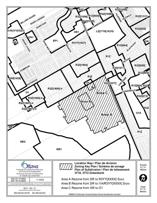
The subject lands are located on the west side of Greenbank Road, approximately 400 metres south of Cambrian Road within the Barrhaven South Community. The vacant site is 28 hectares in size and dominated by agricultural fields with small areas of woodlands and hedgerows. The lands are known as “Half Moon Bay South”. Immediately to the north are lands recently approved for a residential subdivision known as “The Meadows”, to the east is the “Stonebridge Community” and to the south and west are vacant urban lands.
Purpose of Zoning Amendment
The purpose of this Zoning By-law Amendment is to allow for the development of a new subdivision which will contain approximately 680 residential units. There will be a range of housing types including single-detached, street townhouses, rear lane townhouses and back-to-back townhouses. An elementary school and park are also proposed to be developed. The related plan of subdivision application was draft approved on April 1, 2011.
Existing Zoning
The subject lands are zoned DR (Development Reserve). The purpose of the Development Reserve Zone is to recognize lands intended for future urban development while allowing limited interim uses.
Proposed Zoning
The proposed zoning is to change the existing zoning from DR (Development Reserve) to the following parent zones: R3YY[XXXX]Sxxx (Residential Third Density Subzone YY, Exception XXXX, Schedule xxx), I1A (Minor Institutional Subzone A), and O1 (Parks and Open Space).
DISCUSSION
Official Plan and Community Design Plan
The lands are designated as General Urban Area in the Official Plan and are located in Area 3 of the Barrhaven South Community Design Plan (CDP). The CDP requires that low and medium density residential units, an elementary school and a portion of a neighbourhood park be developed on the subject lands.
Proposed Draft Plan of Subdivision
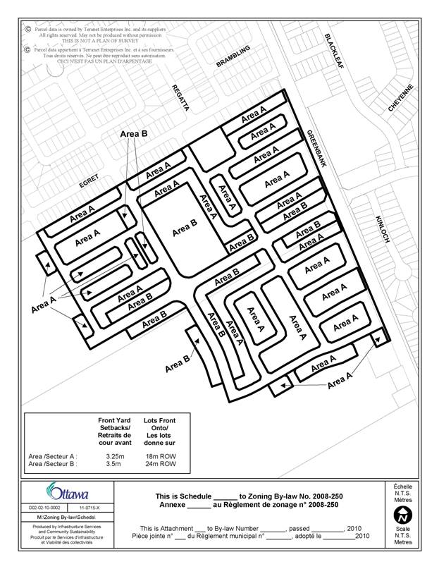
The proposed subdivision contains a grid of local public streets with widths of 18.0 metres and two collector streets of 24.0 metres in width. Sidewalks will be constructed along most streets to connect the residential uses with amenities such as parks and schools. The subdivision will be accessed from Greenbank Road and roads from the approved subdivision to the north. The draft plan of subdivision includes a mix of housing types including detached, semi-detached, rear lane townhouses and back-to-back townhouses with an overall net density of 44 units per hectare, excluding municipal roads.
A 2.1 hectare school site, currently reserved for the French Catholic School Board, is proposed in the centre area of the plan of subdivision. A 0.55-hectare park is proposed along the northern portion of the land which will be assembled with a future park to be located on the proposed subdivision to the north. The proposed transportation network and land uses conform to the CDP.
Details of Proposed Zoning
The proposed zone for Area A, as
shown on Document 1, is R3YY[XXXX]Sxxx – Residential Third Density Subzone YY Exception XXXX
Schedule xxx, which permits a range of residential uses including
single-detached, semi-detached and multiple attached dwellings. The amendment
would establish site specific zoning provisions for the residential uses
including minimum lot area, minimum lot width and yard setbacks. It would also include special zone provisions
such as permitted projections, required distance between an attached garage and
sidewalk and provisions for townhouses on a public lane. Of special interest is a provision for front
yard setbacks which will require a setback of 3.25 metres for lots fronting on
an 18.0 metre road right of way width and 3.50 metres on a 24.0 metre right of
way width. Adjacent subdivisions have been approved with minimum front yard
setbacks as low as 3.0 metres on 16.5 metres wide right of ways, however, in
this particular subdivision there is a requirement to increase the minimum
front yard setbacks and increase the road right of ways widths from 16.5 metres
to 18.0 metres in order to ensure a minimum separation distance of 5.5 metres
between street trees and the front portion of the dwelling. The amendment would also increase the permitted number of
attached dwelling units in a multiple attached dwelling from eight to 16 to
facilitate the development of back-to-back townhouses, however, no single row
would have more than eight dwelling units, thus maintaining the design
objectives of the original zoning provision.
The proposed school site will receive a dual zoning of I1A/R3YY[XXXX]Sxxx. The Zoning By‑law permits two zones to be applied to a property such as a vacant school site to allow for the possibility that should the French Catholic School Board or other school boards decide not to purchase the site, the site could be developed for residential use, similar in nature to surrounding residential uses, without the need to apply for a zoning amendment.
Summary
Staff recommends approval of the Zoning By-law amendment as it complies with the Official Plan and CDP. The proposed zones are suitable to ensure development is in accordance with the designated uses and the special provisions are necessary to permit the proposed development and to address staff concerns.
RURAL IMPLICATIONS
N/A
CONSULTATION
Notice of this application was carried out in accordance with the City's Public Notification and Consultation Policy. The City did not receive any negative comments or opposition to this application.
COMMENTS BY THE WARD COUNCILLOR(S)
The Ward Councillor is aware of this application and the staff recommendation.
LEGAL IMPLICATIONS
There are no legal implications associated with this
report.
RISK MANAGEMENT IMPLICATIONS
There are no risk management implications associated with this report.
FINANCIAL IMPLICATIONS
There are no direct financial implications associated
with this report.
TECHNOLOGY IMPLICATIONS
CITY STRATEGIC PLAN
The proposed development is in harmony with the City Strategic Plan in that it provides a mix of various dwelling types which contribute to a range of choice of housing. The grid layout of the development helps create a walking, transit, and cycling-oriented community. The infrastructure required for the development is planned to be built or improved as needed to service the growth.
APPLICATION PROCESS TIMELINE STATUS
The application was not processed by the "On Time Decision Date" established for the processing of Zoning By-law amendments due to the need to review the related draft plan of subdivision application prior to the approval of this Zoning By-law amendment application.
SUPPORTING DOCUMENTATION
Document 1 Location Map
Document 2 Zoning Schedule
Document 3 Details of Recommended Zoning
DISPOSITION
City Clerk and Solicitor Department, Legislative Services to notify the owner, applicant, OttawaScene Canada Signs, 1565 Chatelain Avenue, Ottawa, ON K1Z 8B5, Ghislain Lamarche, Program Manager, Assessment, Financial Services Branch (Mail Code: 26-76) of City Council’s decision.
Planning and Growth Management to prepare the implementing by-law, forward to Legal Services and undertake the statutory notification.
Legal Services to forward the implementing by-law to City Council.
LOCATION MAP DOCUMENT
1
ZONING SCHEDULE DOCUMENT 2
DETAILS OF RECOMMENDED ZONING DOCUMENT
3
1.
Rezone the subject lands shown on Document 1 as
follows:
a.
Area A from DR to R3YY[XXXX] SXXX;
b.
Area B from DR to I1A / R3YY[XXXX] SXXX; and,
c.
Area C from DR to O1
2.
Add a new exception, R3YY[XXXX] SXXX, to Section 239
with provisions similar in effect to the following:
(i)
In Column II the text “R3YY[XXXX] SXXX”
(ii)
In Column IV
(iii)
In Column V:
“General:
- where a driveway leading to an attached garage abuts a sidewalk the vehicular
entrance to the attached garage must be setback a minimum of 6 m from the
nearest edge of the sidewalk
- the vehicular entrance of an attached garage may not be located more than 2m
closer to the front lot line than either the front wall of the main building or
the leading edge of a roofed porch
- minimum density is 29 units per net
hectare
- despite clause 59(1)(b), access to a lot may be provided by means of a public
lane a minimum of 8.5 metres in width instead of by a public street
- when access to a lot is provided by a
public lane a minimum of 8.5m wide, and
that lot also abuts a park, that lot line abutting the park is deemed the front
lot line and the public lane shall be considered an improved public street for
the purposes of section 59
-despite Section 65:
(i) except for a cantilevered foundation, no
part of a foundation for a permitted projection is permitted within a front
yard;
(ii) an air conditioner condenser may be
located in the front yard of a multiple attached dwelling containing dwelling
units attached back to back;
(iii) eaves, eaves-trough, gutters,
chimneys, chimney box, fireplace box, , and ornamental elements such as sills,
belt courses, cornices, parapets and
pilasters may project:
(a)1m into the required front and corner side
yard and as close as 0 m to a lot line; and,
(b) 1m into the interior side yard, but no
closer than 0.2m to the lot line
(iv) a deck may project 2m into a rear and interior side yard, but no closer
than:
(a) 0.3m of a rear and interior side lot
line if below 0.3 m in height; and;
(b) if above 0.3 m in height, an additional
0.3m setback from a rear and interior side lot line for each additional 0.3 m
high portion of the deck
(v) steps attached to a porch may project
2.5m, but no closer than 0.5m to a lot line
(vi) air conditioning units may project 1m
into a corner and interior side yard and 2m into a rear yard, but no closer
than 0.2m to a lot line
- despite Section 57, the size of the required corner sight triangle will be as
per the approved plan of subdivision
- in the case of a home based business
operating within a multiple attached or semi-detached dwelling, the required
parking space is only required if the business involves a non-resident employee
- no more than 60% of the area of any front yard or corner side yard may be
used as a driveway
-despite Section 136, a multiple attached dwelling may contain a maximum of 16 dwelling units,
however no more than eight dwelling units may be provided in a single row
- no visitor parking is required for a
multiple attached dwelling on a lot that abuts a public lane
For detached dwellings:
- minimum lot area is 220m²
- minimum front yard setback is as per schedule XXX.
- minimum rear yard setback on a corner lot is 0.6m
- minimum corner side yard setback is 2.5m
- maximum lot coverage is 55%
For semi-detached dwellings:
- minimum lot area is 137m²
- minimum lot width is 5.5m
- minimum front yard setback is as per schedule XXX.
- minimum corner side yard setback is 2.5m
- maximum lot coverage is 65%
For multiple attached dwellings:
- minimum lot area is 81m²
- minimum lot width is 4m
- minimum front yard setback is as per schedule XXX.
- minimum setback from a lot line abutting a public lane is 0m
- minimum rear yard setback where dwelling
units are attached back to back: 0m
- minimum corner side yard setback is 2.5m
- minimum interior side yard setback is 1.5m
- maximum building height is 14m”
3.
Add Document 3 to Part 17 – Schedules as Schedule XXX