|
8. ZONING - 3895 GREENBANK ROAD ZONAGE –
3895, CHEMIN GREENBANK |
Committee
recommendation
(This matter is
Subject to Bill 51)
That Council approve an amendment to Zoning By-law 2008-250 to change the zoning of 3895 Greenbank Road from Development Reserve Zone (DR) to Residential First Density Subzone Z (R1Z) as shown on Document 1.
Recommandation DU Comité
(Cette question est assujettie au Règlement 51)
Que le Conseil approuve une modification du Règlement municipal de
zonage 2008 250 afin de changer la désignation de zonage des 3895, chemin
Greenbank de DR (Zone d’aménagement futur) à R1Z (Zone résidentielle de densité
1), comme il est indiqué dans le Document 1.
Documentation
1.
Deputy
City Manager's report, Infrastructure
Services and Community Sustainability, dated 25 July 2011 (ACS2011-ICS-PGM-0165).
Report to/Rapport au :
Comité
de l'urbanisme
and Council / et au Conseil
25 July 2011 / le 25 juillet 2011
Submitted by/Soumis par :
Nancy Schepers, Deputy City Manager/Directrice
municipale adjointe, Infrastructure Services
and Community Sustainability/Services d’infrastructure et Viabilité des
collectivités
Contact
Person/Personne-ressource : Derrick Moodie, Acting Manager/Gestionnaire
intérimaire, Development Review-Suburban Services/Examen des projets
d'aménagement-Services suburbains, Planning and Growth Management/Urbanisme et
Gestion de la croissance
(613)
580-2424, 15134 Derrick.Moodie@ottawa.ca
|
|
|
|
OBJET : |
REPORT RECOMMENDATION
That the recommend Council approve an amendment to
Zoning By-law 2008-250 to change the zoning of 3895 Greenbank Road from Development
Reserve Zone (DR) to Residential First Density Subzone Z (R1Z) as shown on
Document 1.
RECOMMANDATION
DU RAPPORT
Que le Comité de recommande au
Conseil d'approuver
une modification du Règlement municipal de zonage 2008 250 afin de changer la
désignation de zonage des 3895, chemin Greenbank de DR (Zone d’aménagement
futur) à R1Z (Zone résidentielle de densité 1), comme
il est indiqué dans le Document 1.
BACKGROUND
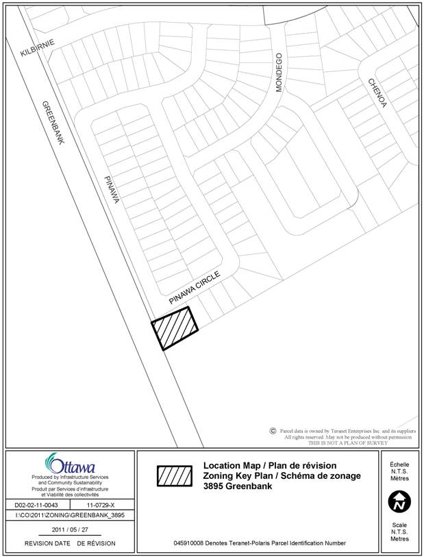
The site, 3895 Greenbank Road, is located east of Greenbank Road at the south end of urban area boundary. It is immediately adjacent to the Stonebridge development Phase 12.
Currently, the 0.17 ha land contains a one-storey, single detached, rural residential building with an access from Greenbank Road. To the north and east are planned residential lands which are zoned R1Z; to the west are vacant urban lands for future development; to the south are rural lands.
Purpose of Zoning Amendment
The intention is to rezone the subject land from Development Reserve (DR) to Residential First Density Subzone Z (R1Z) to allow development of three single detached homes.
DISCUSSION
Official Plan
The Official Plan designates the property
General Urban Area. This designation
permits the development of a full range and choice of housing types to meet the
needs of all ages, incomes and life circumstances, in combination with
conveniently located employment, retail, service, cultural leisure and
institutional uses.
Details of Proposed Zoning
The proposed zoning is Residential First Density Zone; subzone Z (R1Z), which restricts the built form to single detached dwellings. The intention of the proposal is to construct three single detached dwellings with access from local street Pinawa Circle.
Rationale
The proposal is in harmony with the intent of Official Plan policies and compatible with the surrounding community. The proposed R1Z zone is consistent with the existing zoning of the Stonebridge Phase 12 development immediately adjacent to the site. The three lots to be created will be integrated into the fabric of the overall Stonebridge development. As a consequence of the proposed development, a 13-metre strip of land will be dedicated to the Greenbank Road right-of-way.
The proposal is appropriate for the subject property and adjacent public roadway. Staff recommend approval.
Concurrent Application
Consent to sever the property to create three additional lots have been granted by the Committee of Adjustment with conditions to fulfill (File No. D08-01-11/B-00209-212).
RURAL IMPLICATIONS
The subject property is adjacent
to General Rural Area to the south. Given the small scale and straight forward
nature of the proposal there are no rural
implications associated with this report.
CONSULTATION
Notice of this application was carried out in accordance with the City's Public Notification and Consultation Policy. The City did not receive any negative comments or opposition to this application.
COMMENTS BY THE WARD COUNCILLOR(S)
The Ward Councillor has no objections.
LEGAL IMPLICATIONS
There are no legal
implications associated with this report.
RISK MANAGEMENT IMPLICATIONS
N/A
FINANCIAL IMPLICATIONS
There are no direct financial implications associated
with this report.
ENVIRONMENTAL
IMPLICATIONS
There are no environmental
implications associated with this report.
TECHNOLOGY IMPLICATIONS
CITY STRATEGIC PLAN
The proposed development is in harmony with the City Strategic Plan in that it provides a compatible development with the surrounding area.
APPLICATION PROCESS TIMELINE STATUS
This application was processed by the "On Time Decision Date" established for the processing of Zoning By-law amendment applications.
SUPPORTING DOCUMENTATION
Document 1 Location Map
DISPOSITION
City Clerk and Solicitor Department, Legislative Services to notify the owner, applicant, OttawaScene Canada Signs, 1565 Chatelain Avenue, Ottawa, ON K1Z 8B5, Ghislain Lamarche, Program Manager, Assessment, Financial Services Branch (Mail Code: 26-76) of City Council’s decision.
Planning and Growth Management to prepare the implementing by-law, forward to Legal Services and undertake the statutory notification.
Legal Services to forward the implementing by-law to City Council.
LOCATION MAP DOCUMENT
1