|
4. ZONING – 265 CATHERINE STREET
ZONAGE – 265, RUE CATHERINE
|
Committee recommendation AS AMENDED
(This matter is Subject to Bill 51)
That Council approve an amendment to Zoning By‑law 2008-250 to change the zoning of 265 Catherine Street, as shown on Document 1, from T2A (Ground Transportation Facility Zone) to GM [xxxx] (yyy) (General Mixed Use Zone [xxxx] S(yyy)) as detailed in Documents 2 and 3; and that the following changes be made to the details of the recommended zoning contained in Document 3 of the staff report:
Add the following statement:
In column III the text:
· bus station
Add the following to the existing column V changes:
vi. Notwithstanding the above, a bus station must comply with the provisions of Table 210, Column I of the T2 zone.
That there be no further notice pursuant to Section 34 (17) of the Planning Act.
Recommandation MODIFIÉE DU Comité
(Cette question est assujettie au Règlement 51)
Que le Conseil approuve une modification au Règlement de zonage 2008-250 afin de changer la désignation de zonage du 265, rue Catherine, tel qu’indiqué dans le document 1, de T2A (Zone d’installation de transport terrestre) à GM[xxxx] (yyy) (Zone d’utilisations polyvalentes générale [xxxx] S(yyy)), comme il est expliqué en détail dans les documents 2 et 3; et que les changements suivants seront effectués aux détails du zonage recommandé contenus dans le Document 3 du rapport du personnel:
Ajouter l’énoncé suivant :
Dans la colonne III, le texte :
· station d’autobus
Ajouter ce qui suit aux changements de la colonne V actuelle :
vi. nonobstant ce qui précède, une station d’autobus doit se conformer aux conditions du Tableau 210, Colonne I de la zone T2.
Qu’aucun autre avis ne soit donné conformément au paragraphe 34(17) de la Loi sur l’aménagement du territoire.
Documentation
1. Deputy City Manager's report, Infrastructure Services and Community Sustainability, dated 15 August 2011 (ACS2011-ICS-PGM-0179).
2. Extract of Draft Minutes 19, Planning Committee meeting of 13 September 2011
Report to/Rapport au :
Comité de l'urbanisme
and Council / et au Conseil
15 August 2011 / le 15 août 2011
Submitted by/Soumis par : Nancy Schepers, Deputy City Manager/
Directrice municipale adjointe, Infrastructure Services and Community Sustainability/Services d’infrastructure et Viabilité des collectivités
Contact Person/Personne-ressource : Richard Kilstrom, Acting Manager/Gestionnaire intérimaire, Development Review-Urban Services, Inner Core/Examen des projets d'aménagement-Services urbains, Unité du Centre intérieur
Planning and Growth Management/Urbanisme et Gestion de la croissance
(613) 580-2424, 22379 Richard.Kilstrom@ottawa.ca
|
SUBJECT: |
|
|
|
|
|
OBJET : |
That the recommend Council approve an amendment to Zoning By‑law 2008-250 to change the zoning of 265 Catherine Street, as shown on Document 1, from T2A (Ground Transportation Facility Zone) to GM [xxxx] (yyy) (General Mixed Use Zone [xxxx] S(yyy)) as detailed in Documents 2 and 3.
RECOMMANDATION DU RAPPORT
Que le Comité de l’urbanisme recommande au Conseil d’approuver une modification au Règlement de zonage 2008-250 afin de changer la désignation de zonage du 265, rue Catherine, tel qu’indiqué dans le document 1, de T2A (Zone d’installation de transport terrestre) à GM[xxxx] (yyy) (Zone d’utilisations polyvalentes générale [xxxx] S(yyy)), comme il est expliqué en détail dans les documents 2 et 3.
BACKGROUND
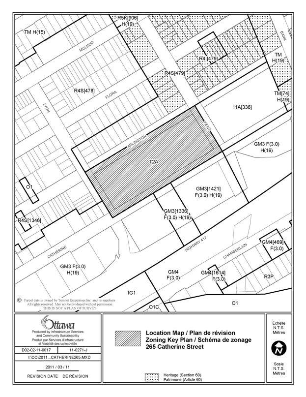
The subject lands, 265 Catherine Street, are comprised of one block bounded by Kent Street to the east, Arlington Avenue to the north, Lyon Street to the west and Catherine Street to the south. Kent Street is a one-way arterial heading north, Lyon Street is a one-way arterial heading south, Catherine Street is a one-way arterial heading west and Arlington Avenue is a two-way local street. Kent Street serves as an off-ramp to Highway 417 which runs in an east/west direction south of the site. Lyon Street serves as an on-ramp to Highway 417. The property currently contains an inter-city bus station leased to the Greyhound Canada Transportation Corporation. The existing building has vehicular access from Catherine Street with the remainder of the site being enclosed with fencing.
The surrounding land uses are a mix of residential uses to the north and west. Directly across Kent Street to the east is a school that occupies the majority of the block between Kent Street and Bank Street. There is a four-storey apartment building at the southwest corner of Arlington and Lyon Streets. The south side of Catherine Street contains a variety of commercial uses and further to the south is Highway 417.
A Site Plan Control application is required to facilitate the construction of the proposed development, however, at this time, such an application has not been submitted to the City.
Proposed Development Concept
The applicant has indicated that this application has been made in response to the possibility that the current tenant (Greyhound Canada) may relocate its operations. At this time, such relocation has not been formally determined. The Department has not been made aware of any plans to develop an intercity bus terminal elsewhere in the city.
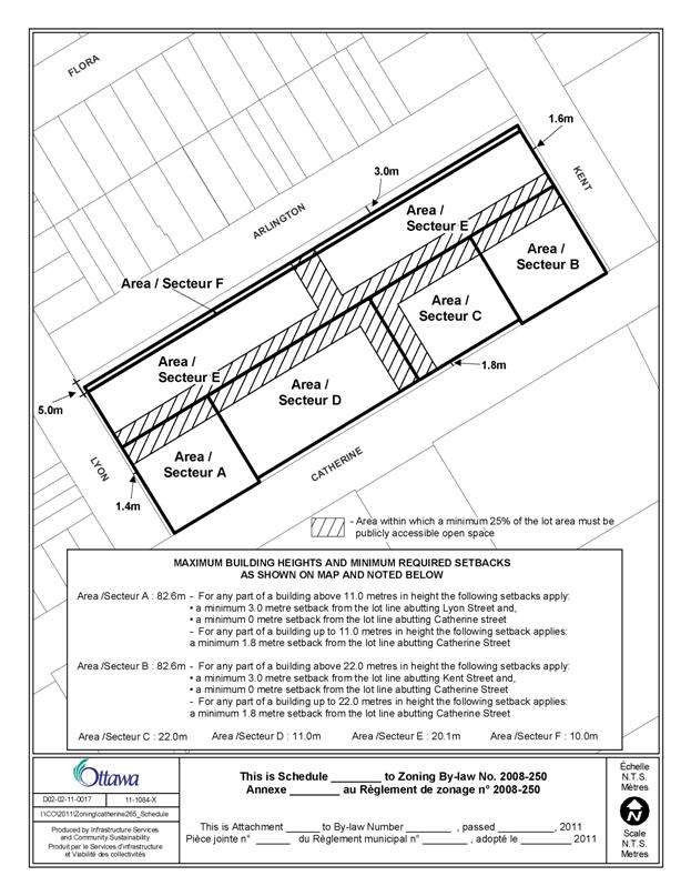
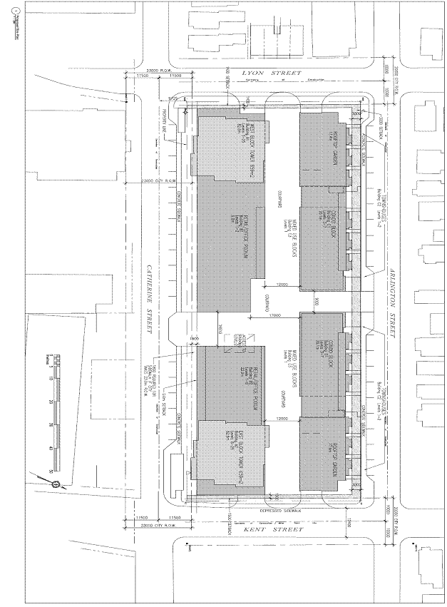
The proposed development consists of a mixed-use development consisting of residential, commercial and office uses. There are four separate buildings proposed for the site with mid-block connections running east/west and north/south converging in the centre of the block at a courtyard area. The mid-block pedestrian connection and courtyard area comprises approximately 26% of the lot area. Two of the four buildings are designed to face Arlington Avenue with ground oriented residential units. The height along Arlington Avenue is proposed to be three-storeys (ten metres) at the front and stepping back to seven-storeys (20.1 metres).
The other two buildings are proposed to face Catherine Street. The majority of the length of the westerly building is proposed to have a two-storey (11.0 metres) component for retail and/or office uses. There is a 23-storey high-rise apartment dwelling proposed at the westerly side of this building on top of the two-storey component with a total height of 82.6 metres (25 storeys). The easterly building is of a similar design, however features a six-storey component for retail and/or office uses with a 19-storey high-rise apartment dwelling at the easterly portion on top of the six-storey component, with a total height of 82.6 metres (25 storeys). The portion of both buildings containing the high-rise apartment dwellings will be set back 3.0 metres from Catherine, Kent and Lyon Streets.
The retail component of this proposal anticipates up to two outlets with larger floor plates and a number of smaller storefronts facing Catherine, Kent and Lyon Streets. In addition, on the north side of the east-west mid-block walkway, the proposal incorporates continuous ground-accessed live-work units.
The Department has had discussions with the applicant regarding the mid-block connections and courtyard area. To ensure that these connections and courtyard area remain open to the public, the City will be requiring an easement over the areas at the Site Plan Control stage. The details of this public easement will be determined during the Site Plan stage in consultation with the applicant, Ward Councillor and City Staff.
It is noted that the circulation of the application did not clearly describe the proposal with respect to the total height of the two towers. Both towers are proposed to be 25 storeys in height (82.5 metres). The westerly tower is proposed to have the residential portion comprised of 23-storeys on top of a two-storey mixed use podium. The easterly tower is proposed to have the residential portion comprised of 19-storeys on top of a six-storey mixed use podium.
A concept plan of the proposed development can be found in Document 4.
Existing Zoning
The property is currently zoned Ground Transportation Facility (T2A) which is reflective of the current use of the property as a bus station. The T2A zone provides limited transportation related uses including a bus station, parking garage, parking lot and train station. There are also a small number of accessory uses permitted such as a bank machine, restaurant, retail store and convenience store.
Purpose of Zoning Amendment
The proposed Zoning By-law amendment is to permit the development of the proposed mixed use buildings. The amendment is proposing to change the zoning from the T2A zone to an General Mixed Use Zone (GM) with site-specific provisions to allow for a bus station as a permitted use, a reduction to the parking rates, varying building heights, mid-block connections, a courtyard and specific provisions to ensure that the ground-oriented units and ground floor retail are developed with direct access to the street.
Proposed Zoning
The Zoning By-law amendment proposes to modify the zoning on the property as follows:
- amend the T2A zone to a GM zone;
- all residential units on the ground floor have their primary entrance facing Arlington Avenue, Lyon Street and Kent Street;
- all commercial units on the ground floor have their primary entrance facing Catherine Street;
- reduce the parking rates; and
- add a schedule to reflect the proposed heights, the amount of open space on the property, and the setbacks of the buildings from each street edge.
It should be noted that the setbacks from Kent, Lyon and Catherine Streets take into account the future road widening of each street which will be taken at the Site Plan Control stage.
DISCUSSION
Planning Act and Provincial Policy Statement
Section 2 of the Planning Act outlines those land use matters that are of provincial interest, to which all City planning decisions shall have regard. The provincial interests that apply to this site include the appropriate location of growth and development and the promotion of development that is designed to be sustainable to support public transit and to be oriented to pedestrians.
In addition, the Planning Act requires that all City planning decisions be consistent with the Provincial Policy Statement (PPS), a document that provides further policies on matters of provincial interest related to land use development. The PPS contains policies which indicate that there should be an appropriate mix of uses to support strong, liveable and healthy communities.
The proposed zoning allows for an increase of residential units and opportunities for new commercial and office uses, which will efficiently re-use land and contribute to a balanced community. The site is surrounded by three arterial roads (Kent, Lyon and Catherine). The access is proposed from both Kent and Lyon Streets. The site is served by OC Transpo bus routes. Nearby residential and commercial areas allow for access by pedestrians and transit. The Department is of the opinion that the proposal is consistent with the matters of provincial interest as outlined in the Planning Act and PPS.
Official Plan
Strategic Directions and Land Use Designation
Section 2.3.1 of the Official Plan sets broad strategic directions to meet the challenge of managing growth and directing growth to the urban area where services exist, providing infrastructure, maintaining environmental integrity and creating livable communities within Ottawa. To meet these challenges, polices are set out to pursue compact forms of development which in turn will enable the City to support a high-quality transit system and make better use of existing infrastructure and roads.
The site is designated General Urban Area on Schedule B of Volume 1 of the Official Plan. The General Urban designation is intended to facilitate the development of complete and sustainable communities with a full range and choice of housing, in combination with conveniently located employment, retail, service, cultural, leisure, entertainment and institutional uses. The Official Plan supports infill development and intensification within the General Urban Area, provided it is developed in a manner that enhances and complements the desirable characteristics of the existing community and ensures its long term vitality of the existing community. The Official Plan further requires that uses that serve wider parts of the city will be located at the edges of neighbourhoods on roads where the needs of these land uses, such as transit, access and parking can be more easily met and their impacts controlled.
Section 2.2.3 “Managing Growth within the Urban Area” provides direction for intensification in the General Urban area. Where a Zoning By-law Amendment is required to facilitate intensification, the appropriateness of the scale of development will be evaluated along with the design and its compatibility.
In addition, the policies provide for consideration of intensification and infill development when the lands are within 600 metres of a future or existing rapid-transit station, lands that are no longer viable for the purpose for which they are intended or are currently or formerly used as parking lots.
The site is located at the southern edge of Centretown. The property is bound by three arterial streets; Kent Street is a northbound arterial that serves as an access route to the Central Area, and Lyon Street is a southbound arterial that serves as an access route from the Central Area to Highway 417. The subject property currently contains a bus station leased to the Greyhound Canada Transportation Corporation. The applicant has indicated that a renewal of the long-term lease with Greyhound may not be secured and thus has applied for this Zoning By-law Amendment with the intention that if future leases with a bus company cannot be secured, the property can be redeveloped. The proposal provides an opportunity for a mixed-use development to serve the local population in the urban area, which supports the overall goals and policies of the Official Plan’s Strategic Directions and General Urban designation.
Centretown Secondary Plan
The Centretown Secondary Plan in Volume 2 of the Official Plan intends to conserve and enhance the residential character of Centretown as an inner-city community with several identifiable neighbourhoods focused around defined commercial corridors and public open spaces.
The Secondary Plan recognizes that the population of Centretown will increase over time, and that this increase will support the residential character of the area and benefit the retail and commercial enterprises within Centretown and the adjacent Central Area. The Plan also recognizes that an increase in population in Centretown will also be beneficial to the city-wide distribution of population and the use of existing public services and facilities. The Secondary Plan acknowledges that Centretown will absorb some of that anticipated increase in population. The land use schedule defines the land use designations which are reflective of the desired use and built form patterns for the area. These designations are intended to serve as a framework within which the objectives and policy directions of the Secondary Plan are to be achieved.
The subject lands are designated as “Queensway Commercial Area” on Schedule H of the Centretown Secondary Plan. The Queensway designation extends east and west of the site over to Bronson Street and east to Elgin Street. This designation recognizes that historic use of this property and others in the area as commercial and wholesale operations which serve travellers and commuters, and anticipates that this corridor will continue to fulfill a commercial function to serve city-wide as well as area residents. The Queensway designation states that residential uses are not considered compatible, however the use is not prohibited by the Secondary Plan.
As this property encompasses an entire city block, it is a rare situation where larger retail uses can be accommodated in an urban area of the city in a pedestrian-friendly format. Residential uses on the ground floor are proposed on the south side of Arlington Avenue across the street from existing low-rise residential uses. This provides a transition from the existing low-rise uses along Arlington Avenue in both use and height, to the commercial, office and high-rise residential uses on the southern portion of the subject lands. The proposed rezoning is in keeping with the intent of the policies of the Centretown Secondary Plan.
In addition, this property has been included in the new Centretown Community Design Plan which is currently underway. This proposal is consistent with the draft version of the Mid-Centretown Community Design Plan, wherein this property is proposed to be part of the Catherine Street Corridor area which permits building heights up to 25 storeys.
Compatibility and Community Design
Section 2.5.1 of the Official Plan recognizes the importance of compatibility and community design when considering new development. The Official Plan recognizes in order for a development to be compatible, it does not necessarily have to be the same or similar as the existing buildings in the vicinity. Rather, compatible development enhances an established community and coexists with existing development without causing undue adverse impact on surrounding properties. The Official Plan provides objective criteria to evaluate compatibility in Section 4.11.
Section 2.5.1 also addresses community design and acknowledges that good urban design and quality architecture can create lively places with distinctive character which provide tools to shape the environment. This section provides a set of design objectives and principles to be considered in evaluating development proposals. The design objectives include:
· enhancing a sense of community by creating distinct places;
· defining quality public and private spaces;
· creating spaces that are safe and accessible;
· ensuring that new development respects the character of existing areas;
· considering adaptability and diversity when creating spaces; and
· understanding and respecting natural processes and promoting environmental sustainability in development.
The subject property is within the area which requires review by the Urban Design Review Panel (UDRP). The applicant presented the proposal to the UDRP in June 2011 and the comments of the panel are provided as Document 5.
As previously mentioned, Section 4.11 of the Official Plan provides objective criteria to evaluate compatibility. In addition, in 2009, City Council approved Urban Design Guidelines for High-Rise Housing as well as Transit-Oriented Guidelines which were approved in 2007. The following is an analysis of the applicable criteria, including the comments from the UDRP, which demonstrates that the proposed development satisfies the compatibility tests of the Official Plan in a manner that does not result in undue adverse impacts.
Policy 1 of Section 4.11 recognizes that compatibility is not the only tool to evaluate development proposals, and that the City must have regard for the policies of Section 4.1 through 4.10, the objectives of Section 2.5.1, and the policies of any applicable Secondary Plans or site-specific policies. As previously discussed, the proposal meets the intent of the Centretown Secondary Plan, satisfies the policies of the Strategic Directions as contained in the Official Plan, and the Department is satisfied that the applicable policies contained in Sections 4.1 through to 4.10 are also met.
Policy 2 of Section 4.11 acknowledges that not all of the objective criteria contained in the Official Plan are meant to be applicable to all circumstances; some may not apply, or may be evaluated and weighed on the basis of site circumstances.
Policy 2(a) requires that roads should be adequate to serve the development with sufficient capacity to accommodate the anticipated traffic generated by the development. Policy 2(b) requires that the vehicle ingress and egress to a development should address impacts such as noise, headlight glare and loss of privacy on development adjacent, or immediately opposite, to the subject property. Vehicular access to the site is proposed to be on both Kent and Lyon Streets which are one-way arterials running north and south, respectively. The locations of the proposed entrances do not infringe on adjacent residential areas and are concentrated in two areas thus minimizing the interruption of pedestrian movement in the area. The design of the mid-block pedestrian connections provides for a more pedestrian-friendly environment. A Community Transportation Study (CTS) was prepared in support of the application, and indicates that the proposed development will result in a modest increase in traffic on most of the adjacent roadway network, with no need for any traffic improvements as a result of the proposed development. Any recommendations of the CTS, as well as site-specific requirements of the City, will be included as conditions of Site Plan Control approval. As per the Transit-Oriented Guidelines, this development is designed with underground parking as well as bicycle parking.
Policy 2(c) requires that a development should have adequate on-site parking to minimize the potential for spill over on adjacent areas. Opportunities should be considered to reduce parking requirements and promote increased usage of walking, cycling and transit, particularly in the vicinity of transit stations or major transit stations in accordance with Section 4.3. The proposed rezoning includes parking provisions considered adequate for the needs of the proposed development while recognizing the opportunity to reduce parking and increase other modes of transportation.
Policy 2(d) addresses building heights and massing recognizing that new buildings should have regard for the area context which includes not only the massing and height of adjacent buildings but also the planned function of the area. The desire for a transition in building heights can be offset where natural buffers and setbacks exist or through the use of appropriate design measures to create a more pedestrian-friendly environment.
With respect to height, the proposal includes the transitioning from the existing low-rise residential areas in the immediate area. As previously mentioned, the proposed buildings which front onto Arlington Avenue are proposed to be seven-storeys with two-storey entrance features and ground-oriented units. These buildings provide transitioning in both use and built from the existing residential uses on the north side of Arlington Avenue.
With respect to massing and transitioning of building heights, the applicant is proposing mid-block connections in an east-west direction providing connection between Kent and Lyon Streets, as well as a north-south mid-block connection providing connection between Catherine Street and Arlington Avenue as per the Urban Design Guidelines for High Rise Housing. These connections provide separation between the proposed buildings, thereby providing sufficient daylight and air circulation which creates a desirable micro-climate. As noted in the comments from the UDRP, the setbacks of the buildings along Arlington Avenue should be increased to allow for substantial tree planting.
The applicant has revised their plan and has proposed a minimum setback along Arlington Avenue of 3.0 metres. The Department is satisfied that this increase will allow for adequate vegetation along the Arlington Avenue frontage. In addition, the UDRP commented on the setback of the tower adjacent to Kent Street and that it should be consistent with the setbacks proposed along Lyon Street. The applicant has amended the plan to allow for a 1.6 metre setback along the Kent and Lyon Streets for the lower-level portions of the buildings, and proposes a 3.0 metre setback for the tower portions of both buildings adjacent to Lyon, Kent and Catherine Streets.
Policy 2(e) recognizes the pattern of the surrounding community and acknowledges that for development that proposes a different height, building mass, proportion, street setback or distance between buildings from the pattern of the area, the design of the proposed building may compensate for this variation. It is the opinion of the Department that the surrounding area contains a variety of building heights, massing, proportions and setbacks. There are a variety of uses in the immediate area ranging from a school, to residential buildings with varying heights, to commercial uses. There are no buildings in the immediate area with heights comparable to the two towers proposed as part of this development, however, it is acknowledged that this proposal is consistent with the draft version of the Centretown CDP, which indicates that this area adjacent to the Queensway is an appropriate area for high-rise residential uses. The same acknowledgement is contained in the comments and recommendations of the UDRP. The Department is satisfied that this proposal is consistent with the existing policies of the Official Plan and Secondary Plan and is reflective of the future planned function of the area.
Policy 2(l) requires that the development provide supporting neighbourhood services, or alternatively, is able to be supported by existing neighbourhood services. As previously mentioned, the site is located within Centretown. The area provides sufficient neighbourhood services for this development.
Other design and compatibility criteria such as noise, lighting, fencing, microclimate and loading areas are addressed through the Site Plan Control process.
Official Plan Amendment 76 (OPA 76)
While Official Plan Amendment 76 is currently under appeal and is not in full force and effect, the amendment was adopted by City Council and thus is taken into consideration in the evaluation of planning applications. When evaluating the appropriateness of a development proposal, one of the main differences between the City of Ottawa’s approved Official Plan and Official Plan Amendment 76, are the compatibility criteria found in Section 4.11.
One new policy is the consideration of whether the design of a proposal takes advantage of opportunities to improve the character and quality of an area and the way it functions. Other new policies appropriate for consideration in a rezoning application are policies related to Building Profile and Compatibility. Development proposals will also address issues of compatibility and integration with surrounding land uses by ensuring an effective transition in built form. This will serve to link the proposed development with existing development.
In terms of height, Official Plan Amendment 76 defines a Mid-Rise as a building of five to nine storeys. The policies recognize that integrating taller buildings within an area characterized by a lower built form is an important design consideration, especially in relation to intensification. The policies further provide criteria to achieve a built form transition by:
a. Incremental changes in building height (e.g. angular planes or stepping building profile up or down);
b. Massing (e.g. inserting ground-oriented housing adjacent to the street as part of a high-profile development or incorporating podiums along a Mainstreet);
c. Character (e.g. scale and rhythm, exterior treatment, use of colour and complementary building finishes);
d. Architectural design (e.g. the use of angular planes, cornice lines); and
e. Building setbacks.
The applicant is proposing to incorporate ground-oriented units along the Arlington Avenue frontage. The proposed setbacks and varying heights of the proposal provides for incremental changes in building height and use. The final architectural design of the proposed building, including the exterior treatment of the building and building finishes, will be implemented through the Site Plan Control process. The Department has had ongoing discussions with the applicant to implement design features that will be beneficial to the design and reflective of these policies. The Department is satisfied that the proposal meets the intent of the policies in OPA 76.
Details of Proposed Zoning
The Zoning By-law Amendment application requests a change to the existing T2A (Ground Transportation Facility zone) to a GM (General Mixed Use zone) with height limits ranging from nine metres to 82.5 metres and varying yard setbacks. The schedule found in Document 2 illustrates the requested height limits and setbacks. The details of the zoning amendment are contained in Document 3. The reduction in parking was considered by the Department and it was determined that a reduction in the visitor parking rate for residential uses from the 0.2 spaces per unit to 0.083 spaces per unit could be accommodated as this rate is consistent with the visitor parking rate contained in the former City of Ottawa Zoning By-law. As the development has not yet been finalized, and as the proposed GM zone allows for a variety of commercial and office uses that require varying parking rates, a reduction in other parking rates would be considered premature at this time.
Servicing Issues
A servicing study was provided in conjunction with the development application and demonstrated that the existing services are adequate to support the proposed development. The Department has reviewed the study and have no issues with the findings with respect to capacity. Further detailed review will be undertaken as part of the Site Plan Control process.
Summary
The proposed development supports the direction of the Planning Act, Provincial Policy Statement and Strategic Directions of the Official Plan. The mixed-use development which is will contribute to a greater housing mix, satisfies density targets for the City and is consistent with the existing applicable policies as well as the polices of OPA 76 and the draft Centretown CDP. Compatibility and design criteria, transportation and servicing have been addressed satisfactorily. In light of the discussion above, the Department recommends approval of the Zoning By-law Amendment application.
ENVIRONMENTAL IMPLICATIONS
A Phase I Environmental Site Assessment was submitted as part of the Zoning By-law Amendment application. No significant issues were identified in the Phase I ESA.
RURAL IMPLICATIONS
N/A
CONSULTATION
Notice of this application was carried out in accordance with the City’s Public Notification and Consultation Policy. The Department received numerous comments from the public and community groups which are included in Document 5.
COMMENTS BY THE WARD COUNCILLOR
There is a strong desire in the community to have the bus station continue to operate in this location. However, should the site become available for redevelopment, the proposed mixed use plan, with low rise, medium rise, and high rise elements separated by open space is a good use of this full block’s potential. I support the massing of the two towers on the Catherine Street frontage, with a podium of commercial uses at grade; low-profile ground oriented residential units along Arlington Avenue to echo the low profile residential community to the north; and mid-rise blocks acting as a transition in the middle. However, I do not see this disposition reflected in the building heights on the Zoning Schedule Document 2, which shows permitted heights of 20.1 metres (Area E) extending all of the way to the Arlington Avenue line. There needs to be a mandatory stepping down to the proposed townhouses along Arlington set into the building envelope as described in the amended zoning by-law.
LEGAL IMPLICATIONS
There are no legal implications associated with this report.
RISK MANAGEMENT IMPLICATIONS
N/A
CITY STRATEGIC PLAN
The proposed development and planning applications align with the City Strategic Plan in that it respects the existing urban fabric, neighbourhood form and the limits of existing hard services so that new growth is integrated seamlessly with established communities; creates a walking, transit, and cycling oriented community; and contributes toward achieving a 30-per cent modal split by 2021.
TECHNICAL IMPLICATIONS
FINANCIAL IMPLICATIONS
There are no direct financial implications associated with this report.
APPLICATION PROCESS TIMELINE STATUS
This application was not processed by the “On Time Decision Date” established for the processing of Zoning By-law Amendment applications.
SUPPORTING DOCUMENTATION
Document 1 Location Map
Document 2 Details of Recommended Zoning
Document 3 Proposed Zoning Schedule
Document 4 Proposed Concept Plan
Document 5 Urban Design Review Panel Recommendations
Document 6 Consultation Details
DISPOSITION
City Clerk and Solicitor Department, Legislative Services to notify the owner, applicant, OttawaScene.com, 174 Colonnade Road, Unit #33, Ottawa, ON K2E 7J5, Ghislain Lamarche, Program Manager, Assessment, Financial Services Branch (Mail Code: 26-76) of City Council’s decision.
Planning and Growth Management to prepare the implementing by-law, forward to Legal Services and undertake the statutory notification.
Legal Services to forward the implementing by-law to City Council.
LOCATION MAP DOCUMENT 1
ZONING SCHEDULE DOCUMENT 2
DETAILS OF RECOMMENDED ZONING DOCUMENT 3
Proposed Changes to the Comprehensive Zoning By-law
1. Rezone the subject lands shown on Document 1 from T2A to GM[XXXX] SYYY;
2. Add a new exception, GM[xxxx] Syyy to Section 239 with provisions similar in effect to the following:
a. In Column II the text “GM[XXXX] SYYY”;
b. In Column IV the text:
drive-through facility
c. In column V the text:
i. For all uses, the wall at grade facing a public street shall contain the principal entrances to each unit and in the case of a corner lot, the principal entrance may be at an angle at the corner of the building facing a street intersection;
ii. For each non-residential unit on the ground floor, the wall at grade facing a public street shall have at least 50% of its facade comprised of windows and its main entrance and, in the case of a corner lot, the principal entrance may be at an angle at the corner of the building facing a street intersection;
iii. Office uses are not permitted on the ground floor except in Area E as set out of Schedule YYY;
iv. Table 187 Rows (c) through (h) inclusive do not apply and all minimum required setbacks and maximum permitted building heights are as set out on Schedule YYY;
v. Minimum visitor parking space rate for a dwelling unit within a building also containing non-residential uses: none for the first 12 dwelling units and 0.083 spaces per unit thereafter.
3. Add to Part 17 – Schedules Document 2 as Schedule yyy
PROPOSED CONCEPT PLAN DOCUMENT 4
URBAN DESIGN REVIEW PANEL DOCUMENT 5
· The Panel appreciates that the applicant has come back for another review.
· The design presented to the Panel is going in the direction proposed by the draft Centretown Community Design Plan and there are a number of positive elements.
· The seven-storey elevation along Arlington is a transition from the five- to nine-storey building form that is envisioned by the Centretown CDP. It is a step in the right direction and will serve as a catalyst for future development, assuming the inventory of buildings to the north changes over time.
· The Panel prefers to see grade-related units facing Arlington.
· The two 25-storey towers planned for the site could overpower the proposed public space, which in its current configuration is questionable for effective public use.
· It is difficult to anticipate the type of retailer who would wish to locate in this development, which is problematic in that such major changes could have a significant impact on the design currently presented before the Panel.
· As a direction to City staff, the Panel suggests that the proposed zoning ensure that the building height of the townhouses be restricted to a maximum of 17 – 20 metres, to prevent any shadowing on the sidewalk on the north side of Arlington.
· The shadows of the towers as shown in the studies extend right off the page; hence, it is felt that the overshadowing impact on the nearby residential community could be substantial, especially on the low profile neighbourhood to the west.
· A varied tower height is worth considering as recommended in such situations by the draft CDP guidelines and in response to the adjacent context and zoning. The Panel would like to see the proposed development made fully compatible with the new Centretown Plan.
· In keeping with the draft Centretown Plan, the planned podium and towers are good, however the Panel recommends stepping back the east tower further from Kent Street.
· A pedestrian, mid-block connection is good and could be enlarged to create a small park consistent with the draft Centretown Plan. The Panel would like to see more on how this develops into a future connection to the blocks to the south and potentially the north. The public realm connections within and around the site need to tie in with other connections.
· The proposal appears to follow the Centretown Plan, in anticipating five- to nine-storey buildings for the north side of Arlington. Based on the presentation made to the Panel and city staff regarding mid-rise infill in Toronto, the Panel feels that more work should be undertaken with respect to “access to light” and how the proposed building heights correlate with the width of the street right-of-ways to specifically address building design, setbacks and the pedestrian environment. This could create a set of rules that the developers and designers could follow, representing best practices and dealing with the issue of stability for the existing community. Other projects could then follow the lead of this project.
· The ground floor setback along Arlington still poses a concern for the Panel and adjustments still need to be made to ensure the successful planting of trees. If the intent is to make this proposal fully compatible with the draft Centretown Plan, the setback of the seven-storey development should be increased to accommodate large, healthy trees in order to replace the line of existing mature trees proposed for removal. In addition, along Catherine Street, the zoning must also ensure adequate street tree planting and sidewalk width.
· The Panel looks forward to seeing the client at a later stage in the process when their site plan application is in motion.
CONSULTATION DETAILS DOCUMENT 6
NOTIFICATION AND CONSULTATION PROCESS
Notification and public consultation was undertaken in accordance with the Public Notification and Public Consultation Policy approved by City Council for Zoning By-law amendments.
PUBLIC COMMENTS
There were 17 members of the public and one community group who provided comments on this application. A summary of the public comments and staff responses are provided below.
SUMMARY OF PUBLIC INPUT
Comment:
HEIGHT
The proposed heights along Arlington Avenue are out of scale compared to the existing residential uses on the north side of Arlington Avenue. The proposed high-rise residential buildings are out of scale with the surrounding area.
Response:
The Department is satisfied that even though there are no existing high-rise buildings in the immediate area, the proposal is consistent with the existing and future planned function of the area. The analysis of the proposal is contained within the discussion section of this report.
Comment:
PARKING/TRAFFIC
There should be at least 1 parking spot per residential unit and additional visitor parking as well as sufficient parking for the commercial and office space. Unless this happens, on-street parking, which is currently insufficient, will worsen.
There is too much parking being provided since most people in this area take the bus, walk or cycle to get around.
Adding entrances from Kent and Lyon Streets will impact the traffic.
Response:
A Community Transportation Study was submitted as part of the Zoning By-law Amendment application which has been reviewed by City staff and deemed satisfactory. The parking is based on the potential of commercial, office and number of residential units. The specific parking requirements will be calculated at the Site Plan Control stage and if at that time there is a deficiency in the parking, it will have to be addressed through the appropriate process. The Department is satisfied that a reduction in the visitor parking rate for the proposed residential uses is appropriate at this time. The mid-block connections are to provide pedestrian connections and enhance the pedestrian-friendly environment. Bicycle parking will be required to be provided during the Site Plan Control stage when the details of the development are determined.
Comment:
BUS STATION
I am concerned with the loss of the bus station.
Response:
The Department is not aware of any immediate plan for the bus station to relocate. Should such a plan come forward, it will be evaluated in the context of all applicable planning and transportation policies and goals.
Comment:
GREENSPACE/OPEN SPACE
Greenspace should be incorporated beyond the landscaping.
Response:
As described in this report, there are two mid-block connections leading to an interior courtyard on the property proposed as part of the Zoning By-law Amendment. To ensure that this area remains accessible to the public, the City will be requiring and easement over these areas. The Department is satisfied that this will provide sufficient open space area for the existing and future residents. The design of these mid-block connections and courtyard area will be determined at the Site Plan Control stage.
The proposal does include rooftop patios on the proposed building which will provide open space for the future residents.
Comment:
USE
There are already too many condos in the area.
Response:
The Secondary Plan recognizes that the population of Centretown will increase over time, and that this increase will support the residential character of the area, benefiting the retail and commercial enterprises within Centretown and the adjacent Central Area. The Plan also recognizes that an increase in population in Centretown will also be beneficial to the City-wide distribution of population and the use of existing public services and facilities. The Secondary Plan acknowledges that the neighbourhoods of Centretown will absorb some of the anticipated increase in population. In order to absorb this anticipated increase in population, new developments, including condominiums which can provide a higher residential density, are necessary. This proposal, as with other condominiums in the area, meets the planned function of the area.
Comment:
SHADOW STUDIES/LOSS OF SUNLIGHT
The height of the proposed buildings would infringe on the light for the surrounding area. The height of the buildings along Arlington will shade the existing residential uses on the north side of Arlington Avenue.
Response:
The sun shadow study submitted with the application does illustrate some shadowing of the surrounding neighbourhood, however the Department is satisfied that the shadowing does not cause undue adverse impacts to the surrounding neighbourhood.
Comment:
I welcome the addition of more residential units and the combined ancillary uses that the project will bring to this Centretown neighbourhood. Such an addition will supply more, hopefully affordable, housing to the area while enhancing the viability of convenience services in it. A good set of objectives will materialize.
Response:
The evaluation of this proposal is contained in the body of this report and is consistent with this comment.
COMMUNITY ORGANIZATION COMMENTS
Centretown Citizens Community Association
The CCCA believes that the current use of the block as a bus station, while not aesthetically pleasing, is very functional in that buses are able to loop easily off the 417 in and out of the station. If it is to be relocated, ideally people should be able to embark closer to the Central Business District and the Transitway.
The CCCA received a presentation in December by FoTenn Consultants and BBB Architects on the potential future plans for the site and were supportive of the concept in general. While proposing uses and densities which are not in compliance with the Centretown Plan, it seemed to be in keeping with the concepts being developed for the Catherine Street Corridor in the context of the Mid Centretown Community Design Plan. (Although only the eastern end of this block was included in the original Terms of Reference for the study, the consultants have expanded the scope and are likely to make proposals for the expanded area, whether we agree or not.)
The CCCA would be supportive of the 15 and 19 storey point towers at the southeast and southwest corners of the site, as presented to us in December, but we understand that this has now changed to 23 storeys which is too high. This development will set the tone for future development of the "Catherine Street Corridor", which has only one block to transition to the low-rise area one block to the north, and all other blocks on the north side of Catherine Street are divided into smaller lots that will likely be developed independently, if ever.
We are concerned that 9 is too high for the north side along Arlington for the following reasons: it is at the top of the mid-rise range abutting a low-rise area which is generally only 3 storeys in height. For comparison, the Tribeca development at 187 Metcalfe has a 7-storey building across from a mid-rise zone. The buildings fronting Arlington should be shorter and more set back in order to ensure the houses on the North side of Arlington have sun in the winter.
Given that there is no decision to relocate the bus station at present, it seems to us to be premature to be dealing with this application and we would propose that the City defer consideration of any zoning changes until the Mid Centretown Community Design Plan is completed so that it can be considered in the context of that plan.
Response:
With respect to the comments regarding height and transitioning, this report contains an analysis of these issues in the discussion section. It should be noted that the buildings along the Arlington Avenue frontage are proposed to be seven-storeys, not nine-storeys as indicated in the above comments.
As previously mentioned, the proposal is consistent with the draft version of the Mid-Centertown CDP and the Department is of the opinion that this proposal is in general conformity with the draft CDP, however the Department also recognizes that this draft CDP is not in full force and effect, and thus cannot rely on the draft policies of this proposed CDP to evaluate this proposal. The proposed Zoning By-law Amendment meets the applicable policies of the Official Plan and the Centretown Secondary Plan.
The Department appreciates and recognizes the value of the location of the existing bus station, however there are no mechanisms to prevent the loss of the bus station at this current location as it is a private matter between the land owner and the tenant (Greyhound Transportation).