|
1. ZONING - 3711, 3715, 3719 AND
3725 CARP ROAD ZONAGE - 3711,
3715, 3719 ET 3725, CHEMIN CARP |
Committee
recommendations
That Council
approve:
1. An amendment to Zoning By-law 2008-250 to change the zoning
of 3711, 3715, 3719 and 3725 Carp Road
from Village Mixed-Use (VM) subject to a Flood Plain Hazard Overlay to Village Mixed-Use with an Exception (VM
[XXXr]) and amend the Flood Plain Hazard Overlay, as shown in Document 1 and
detailed in Document 3;
2. An amendment to the
former Township of West Carleton Zoning By-law to
change the zoning of 3711, 3715, 3719 and part of 3725 Carp Road from General
Commercial Exception 1 - Flood Plain (C1-FP) to General Commercial Exception 1
(C1) and another part of 3725 Carp Road from General Commercial Exception 1
(C1) to General Commercial Exception 1 – Flood Plain (C1-FP) to address
the revised location of the flood plain boundary as shown in Document 2 and detailed in Document
3; and
3. That the implementing
by-law not be forwarded to Council until such time as the City is in receipt of
an Order from the Ontario Municipal Board bringing into effect that part of
Official Plan Amendment No. 76 which adds Policy 12 to Section 4.8.1 providing an exception permitting parking,
drive aisles and associated site alteration within the floodplain on 3711,
3715, 3719 and 3725 Carp Road
Recommandations DU Comité
Que le Conseil approuve:
1. une
modification du Règlement de zonage 2008-250 qui aurait pour effet de changer
le zonage des 3711, 3715, 3719 et 3725 du chemin Carp de zone d'utilisations
polyvalentes de village (VM), affectée d'une désignation superposée de plaine à
risque d'inondation, à zone d'utilisations polyvalentes de village avec
exception (VM [XXXr]) et de modifier la désignation superposée de plaine à
risque d'inondation, tel que le montre le document 1 et que le fait voir en
détail le document 3;
2. une modification du Règlement de zonage de l'ancien
Canton de West Carleton qui aurait pour effet de changer le
zonage des 3711, 3715, 3719 et d'une partie du 3725 du chemin Carp de zone
commerciale générale avec exception 1 – plaine inondable (C1‑FP) à zone commerciale
générale avec exception 1 (C1) et d'une
autre partie du 3725 du chemin
Carp de zone commerciale générale avec exception
1 (C1) à zone commerciale générale avec exception 1 – plaine inondable (C1‑FP), afin de tenir compte de
la modification des limites de la plaine inondable, tel que le montre le
document 2 et que le fait voir en détail le document 3; et
3. la présentation au Conseil du projet de
règlement de mise en œuvre seulement après que la Ville aura reçu l'ordonnance
de la Commission des affaires municipales de l'Ontario rendant opérante la
partie de la modification no 76 du Plan officiel qui ajoute la
politique 12 à la section 4.8.1, ce qui aura pour effet
d'établir une exception autorisant le stationnement, les voies de circulation
et l'aménagement conséquent du terrain sur les propriétés susmentionnées à
l'intérieur de la plaine inondable.
Documentation
Deputy
City Manager's report, Infrastructure
Services and Community Sustainability, dated 15 December 2011 (ACS2012-ICS-PGM-0008).
Report to/Rapport au :
Agriculture and Rural Affairs Committee
Comité d'agriculture et des affaires
rurales
and Council / et au Conseil
15 December 2011 / le 15 décembre 2011
Submitted by/Soumis par :
Nancy Schepers, Deputy City Manager/Directrice
municipale adjointe, Infrastructure Services
and Community Sustainability/Services d’infrastructure et Viabilité des collectivités
Contact
Person/Personne-ressource : Derrick Moodie, Manager/Gestionnaire,
Development Review-Rural Services/Examen des projets
d'aménagement-Services ruraux, Planning and Growth Management/Urbanisme et
Gestion de la croissance
(613)
580-2424, 15134 Derrick.Moodie@ottawa.ca
|
ZONING - 3711, 3715, 3719 AND 3725
CARP ROAD (FILE NO. D02-02-11-0034) |
|
|
|
|
|
OBJET : |
REPORT RECOMMENDATIONS
That the recommend Council approve:
1.
An amendment
to Zoning By-law 2008-250 to change the zoning of 3711, 3715, 3719 and 3725
Carp Road from Village Mixed-Use (VM) subject to a Flood Plain Hazard Overlay
to Village Mixed-Use with an Exception (VM [XXXr]) and amend the Flood Plain
Hazard Overlay, as shown in Document 1 and detailed in Document 3;
2.
An amendment to the former Township of West
Carleton Zoning By-law to change the
zoning of 3711, 3715, 3719 and part of 3725 Carp Road from General Commercial Exception 1 - Flood
Plain (C1-FP) to General Commercial Exception 1 (C1) and another part of 3725
Carp Road from General Commercial Exception 1 (C1) to General Commercial
Exception 1 – Flood Plain (C1-FP) to address the revised location of the flood plain
boundary as shown in Document 2
and detailed in Document 3; and
3.
That the implementing by-law not be forwarded to Council until such time
as the City is in receipt of an Order from the Ontario Municipal Board bringing
into effect that part of Official Plan Amendment No. 76 which adds Policy 12 to Section 4.8.1 providing an
exception permitting parking, drive aisles and associated site alteration
within the floodplain on 3711, 3715, 3719 and 3725 Carp Road.
RECOMMANDATIONS
DU RAPPORT
Que le Comité de l'agriculture
et des affaires rurales recommande au Conseil d'approuver :
1.
une modification du Règlement de
zonage 2008-250 qui aurait pour effet de changer le zonage des 3711, 3715, 3719
et 3725 du chemin Carp de zone d'utilisations polyvalentes de village (VM),
affectée d'une désignation superposée de plaine à risque d'inondation, à zone
d'utilisations polyvalentes de village avec exception (VM [XXXr]) et de
modifier la désignation superposée de plaine à risque d'inondation, tel que le
montre le document 1 et que le fait voir en détail le document 3;
2.
une modification du Règlement de
zonage de l'ancien Canton de West
Carleton qui aurait pour effet de
changer le zonage des 3711, 3715, 3719 et d'une partie du 3725 du chemin Carp
de zone commerciale générale avec exception 1 – plaine inondable (C1‑FP) à zone commerciale
générale avec exception 1 (C1) et d'une
autre partie du 3725 du chemin Carp de zone commerciale générale avec exception 1 (C1) à zone commerciale
générale avec exception 1 – plaine inondable (C1‑FP), afin de tenir compte de la modification des limites
de la plaine inondable, tel que le montre le document 2 et que le fait voir en
détail le document 3; et
3.
la présentation au Conseil du projet de règlement de mise en œuvre
seulement après que la Ville aura reçu l'ordonnance de la Commission des
affaires municipales de l'Ontario rendant opérante la partie de la modification
no76 du Plan officiel qui ajoute la politique 12 à la section 4.8.1, ce qui aura pour effet d'établir une exception
autorisant le stationnement, les voies de circulation et l'aménagement
conséquent du terrain sur les propriétés susmentionnées à l'intérieur de la
plaine inondable.
BACKGROUND
The subject properties are located on the west side of Carp Road, south of Donald B. Munro Drive. The property known as 3725 Carp Road has extensive frontage along the Carp River.
The site is currently used as a truck depot, including maintenance and storage, parking lot and head office for the Karson Group of Companies. The properties also contain a few single detached dwellings along Carp Road. Surrounding the site is a mix of commercial, residential and institutional uses.
The lands are designated Village in
the Official Plan and also identified as part of the Village Core in the
Village of Carp Community Design Plan (CDP). The properties are zoned VM –
Village Mixed-Use Zone in Zoning By-law 2008-250 and are subject to Section 58,
the Flood Plain Hazard Overlay. It is
noted that the current flood plain provisions (By-law 2008‑250) are under
appeal and therefore the former
Township of West Carleton Zoning By-law Flood
Plain provisions remain in force.
Purpose of Zoning Amendment
The purpose of this amendment is to recognize approved changes to the regulatory flood plain and to implement a site-specific policy introduced into the Official Plan through Official Plan Amendment 76 (OPA76). With these changes, the applicant proposes to construct a mixed-use building and an expanded parking area.
More specifically, this application will amend the boundaries of the Flood Plain Hazard Overlay as shown within Part 18 – Zoning Maps to reflect the new flood plain limit (approved by the Mississippi Valley Conservation). Further, an exception to the VM zone is also requested to allow for parking and drive aisles and associated site alteration within the flood plain of the Carp River. This exception to the VM zone reflects the new site specific Official Plan Policy 12 in Section 4.8.1 added by way of amendment through OPA No. 76. To address the current flood plain provisions in effect for these properties this amendment will also revise the former Township of West Carleton Zoning By-law (By-law 266 of 1981) flood plain boundary on Schedule A, Map 6.
Existing Zoning
The properties are currently zoned VM-Village Mixed-Use in Zoning By-law 2008-250 and are subject to a flood plain hazard overlay. The VM designation permits a wide variety of commercial, leisure, institutional and residential, however the appropriateness of these uses are subject to the restrictions of the flood plain.
Section 58 of Zoning By-law 2008-250 remains under appeal, therefore the flood plain provisions within the Former Township of West Carleton By-law 266 of 1981 remain in effect.
Proposed Zoning
As a result of the approved revisions to the flood
plain limit, and the new policy in the Official Plan, the following changes are required:
- Former Township of West Carleton Zoning By-law 266 of 1981 Schedule
A, Map 6 to reflect new flood plain limits as shown on Document 2 and
detailed in Document 3;
- City of Ottawa By-law 2008-250, Part 18 – Zoning Maps to
delineate a new boundary for the Flood Plain Hazard Overlay as shown on
Document 1 and detailed in Document 3; and
- Specific exception to the VM Zone to allow for parking and drive aisles within the regulatory flood plain as detailed in Document 3.
DISCUSSION
Prior to the submission of this application, City and Conservation Authority staff met with the Owner to discuss the future development of this site. The Owner had then expressed a strong desire to relocate his current operation with an idea of redeveloping this site as envisioned by the Village of Carp Community Design Plan.
The approved Community Design Plan for the Village of Carp makes
specific note of the subject properties under Section 4.9 Redevelopment Opportunities. Section 4.9 states:
“There are two
industrial land uses located at each end of the village core, a truck depot and
an auto parts storage yard. At the workshops, participants felt that these uses
were incompatible with the village core and it was suggested that they should
be encouraged to relocate outside the village.
The owner of the truck
depot has indicated that they are planning to move in the next five years. If
sewer capacity is made available and the village grows as anticipated, the
owner would consider building a retail facility on the site. The redevelopment
would provide retail uses as well as parking and act as an anchor at the
southern end of the core. Redevelopment of this site is key to the rejuvenation
of the core area as it is the entry point to the village.”
The result of these discussions identified two concerns which would need
to be addressed prior to the submission of a re-development plan.
The first issue was the discrepancy between the Mississippi Valley Conservation
(MVC) Flood Risk Mapping, the City’s Zoning By-law Flood Plain Overlay and what
the actual site conditions were.
It has been acknowledged by all parties that the discrepancies with the regulatory flood plain was the result of past site grading changes that had been undertaken on portions of these properties without the permission of the Mississippi Valley Conservation (MVC).
In response to these past practices the Owner submitted an application to the MVC (Ontario Regulation 153/06) to gain permission to the place fill and or excavate material from the regulatory flood plain. On July 15, 2010 the MVC issued a permit authorizing a balanced cut and fill within the 1:100 flood plain. Site work has been completed and approved by the MVC. As such the proposed overlay modifications to the City’s Flood Plain Overlay have been accepted by the MVC.
The second issue was concern over the ability of the site to support any
development as envisioned by the CDP. Section 4 of the CDP provides specific policies
for new development in the Village Core.
The objective of this Section is to ensure that new buildings replicate
traditional patterns of the older village development to maintain the village
character. In this particular case when considering
Section 4 of the CDP, new buildings would be constructed close to the
street/sidewalk and be required to provide parking in the rear yard.
The location of this site between the Carp River, the railway line, and
Carp Road, create unique physical constraints to the redevelopment of the site. Any reasonable development approach to this
site would definitely require an amount of parking beyond what the rear yard
could support in terms of the area available outside the regulatory flood
plain. Simply, some of the parking and associated
aisles would need to be located within the edges of the floodplain.
In considering such a request and the current policies of Official Plan
it was determined that an amendment to the Official Plan, would be required to specifically
address this request for parking in the regulatory flood plain.
The Provincial Policy Statement (PPS), more specifically, Section 3.1
Natural Hazards, addresses the issue of development in hazardous lands adjacent to river, stream and small inland lake systems
which are impacted by flooding hazards and/or erosion hazards. Generally, development should be directed
outside of these areas. Development and
site alteration is not permitted within areas that would be rendered
inaccessible to people and vehicles during times of flooding hazards, erosion
hazards and/or dynamic beach hazards. That
said, permission for a limited amount of development and in exceptional
situations, site alteration, may be granted if it can be demonstrated that the
site has safe access appropriate for the nature of the development and the
natural hazard. Such development would
consist of passive non –structural uses which do not affect flood flows, for
example parking lots.
According to the Technical Guide, River and Stream Systems Flood Hazard
Limit prepared by the Ontario Ministry of Natural Resources, 2002, the maximum
depth of flood waters that is considered safe for vehicular access and egress
is 0.3 metres (1.0 foot). At 0.3 metres
depth of water, the typical car would not be significantly affected by flow
velocities up to about 4.5 metres per second (15 feet per second).
The MVC’s modeling data suggests that the over-bank velocity of the
Carp River in this area is below 3.0 metres per second. The MVC found the flow velocity conditions
acceptable for parking and access; however note that the Owner would need to demonstrate
in the final site plan that all proposed parking and access areas would not be
subjected to more than 0.3 metres depth of flooding during a 1:100 year flood
event. Based on an early submission of the proposed development plan (prepared
by Novatech Engineering Consultants, dated March 2009), it appears that this is
achievable.
Based on the acceptance of the supporting technical information, a new
site specific policy addressing parking in the regulatory flood plain was
introduced through the comprehensive five-year review of the Official Plan
(Official Plan Amendment 76). Section
4.8.1 was amended by adding Policy 12 which states:
“Notwithstanding Policy 5 of Section 4.8.1 of the
Official Plan, parking and drive aisles, and associated site alteration may be considered
within the regulatory flood plain of the Carp River for the properties
municipally known as 3725 (3719, 3715, 3711) Carp Road in order to permit
redevelopment in accordance with the CDP for the Village of Carp. Measures will
be taken to ensure existing impacts to the riparian corridor are improved to
the satisfaction of the City of Ottawa and the Conservation Authority”
On May 11, 2009 a Public Meeting before a joint session of the
Agriculture and Rural Affairs and Planning Committee was held to consider the
comprehensive five-year review of the Official Plan. Subsequently, on June 10, 2009 OPA 76 was
approved by City Council.
In summary, based
on the technical and public response to this amendment, staff recommends that
this Zoning By-law amendment be approved.
Of note at the time this amendment was submitted portions of OPA 76 were still under appeal to the Ontario Municipal Board (OMB). Although this specific policy (Policy 12) was not the subject of the appeal, other parts of the Section (Flood Plains Section 4.8.1) were. Should this amendment be approved by the Agriculture and Rural Affairs Committee, the adoption of the by-law by Council must be held pending receipt of the written decision from the Ontario Municipal Board.
RURAL IMPLICATIONS
The proposal is consistent with the Official Plan and the Village of Carp CDP that guides the development of the Village. The proposed Zoning By-law amendment will provide an environment that is conducive to the redevelopment of an industrial site to commercial uses. This conversion will add to the vitality of the village.
CONSULTATION
Notice of this application was carried out in accordance with the City's Public Notification and Consultation Policy. The City did not receive any negative comments or opposition to this application.
COMMENTS BY THE WARD COUNCILLOR
Councillor Eli El Chantiry is aware of the application.
LEGAL IMPLICATIONS
There are no legal implications associated with this report.
FINANCIAL IMPLICATIONS
There are no direct financial implications associated
with this report.
ACCESSIBILITY IMPACT
N/A
ENVIRONMENTAL IMPLICATIONS
All revisions and site work associated with the changes to the regulatory flood plain was reviewed and approved by the Mississippi Valley Conservation.
CITY STRATEGIC PLAN
The recommended Zoning By-law amendment aligns with the City Strategic Plan by preserving rural villages and ensuring that decisions affecting rural communities are made with input from the rural residents.
APPLICATION PROCESS TIMELINE STATUS
The application was not processed by the "On Time Decision Date" established for the processing of Zoning By-law amendments.
SUPPORTING DOCUMENTATION
Document 1 Location Map/Zoning Key Plan City of Ottawa
Document 2 Location Map/Zoning Key Plan former Township of West Carleton
Document 3 Details of Recommended Zoning
Document 4 Consultation Details
DISPOSITION
City Clerk and Solicitor Department, Legislative Services to notify the owner, applicant, OttawaScene Canada Signs, 1565 Chatelain Avenue, Ottawa, ON K1Z 8B5, Ghislain Lamarche, Program Manager, Assessment, Financial Services Branch (Mail Code: 26-76) of City Council’s decision.
Planning and Growth Management to prepare the implementing by-law, forward to Legal Services and undertake the statutory notification.
Legal Services to forward the implementing by-law to City Council.
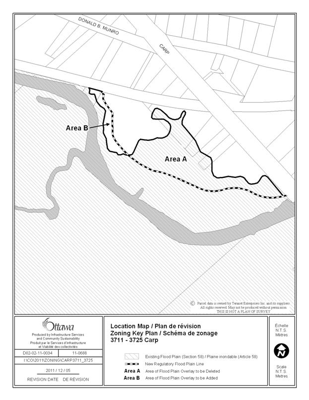
LOCATION MAP/ZONING KEY PLAN CITY OF OTTAWA DOCUMENT 1
LOCATION
MAP/ZONING KEY PLAN
FORMER TOWNSHIP OF WEST CARLETON DOCUMENT 2

DETAILS OF RECOMMENDED ZONING DOCUMENT 3
Proposed
Changes to the Comprehensive Zoning By-law 2008-250
1. Amend Part 18 – Zoning Maps to revise the boundary of the flood plain hazard overlay by deleting the flood plain hazard overlay over that portion of the lands shown in Area A of Document 1, and by expanding the flood plain hazard overlay over that portion of the lands shown in Area B of Document 1;
2. Rezone the subject lands from VM to VM[XXXr]; and,
3. Add a new exception, VM[XXXr] to Section 240 – Rural Exceptions with provisions similar in effect to the following:
a. In Column II the text “VM[XXXr]”; and,
b. In Column V the text:
“- Despite Section 58, parking spaces, aisles and driveways are permitted within the flood plain hazard overlay provided such development is undertaken in accordance with Policy 12 of Section 4.8.1 of the Official Plan for the City of Ottawa.”
Proposed
Changes to the Former Township of West Carleton Comprehensive Zoning By-law 266
of 1981
- Rezone the subject lands shown on
Document 2 as follows:
- Area A is rezoned from C1-FP to C1
- Area B is rezoned from C1 to C1-FP
CONSULTATION
DETAILS DOCUMENT
4
NOTIFICATION AND CONSULTATION PROCESS
Notification and public consultation was undertaken in accordance with the Public Notification and Public Consultation Policy approved by City Council for Zoning By-law amendments.
PUBLIC COMMENTS
Comment:
Is it true that the Karson’s yard between the Carp River and Carp Road in the village has been removed from the flood plain; and if yes, why?
Response:
The current application proposes to amend the floodplain overlay
contained in the Zoning By‑law. Karson Holdings has submitted
the application so that the City’s zoning floodplain would be consistent the
Regulatory Flood Limit administered by the Mississippi Valley Conservation
Authority.
COMMUNITY ORGANIZATION COMMENTS
No comments received.