|
2. COMPREHENSIVE ZONING BY-LAW 2008-250:
ANOMALIES AND MINOR CORRECTIONS - FIRST QUARTER 2012
RÈGLEMENT DE ZONAGE GÉNÉRAL 2008-250: ANOMALIES ET
CORRECTIONS MINEURES – PREMIER TRIMESTRE DE 2012
|
AGRICULTURE AND RURAL AFFAIRS Committee Recommendation
That Council approve the amendments
recommended in Column III of Documents 2 and 3 to correct anomalies in Zoning
By-law 2008-250.
planning Committee recommendation
That Council approve the amendments
recommended in Column III of Documents 1 and 3 to correct anomalies in Zoning
By-law 2008-250.
Recommandation DU Comité de l’agriculture et des affaires rurales
Que le Conseil approuve les modifications préconisées dans la Colonne
III des documents 2 et 3 afin de corriger des anomalies dans le Règlement de
zonage 2008-250.
Recommandation DU Comité de l’urbanisme
Que le Conseil approuve les modifications préconisées dans la Colonne
III des documents 1 et 3 afin de corriger des anomalies dans le Règlement de
zonage 2008-250.
Documentation
1. Deputy
City Manager's report, Infrastructure
Services and Community Sustainability, dated 22 December 2011 (ACS2012-ICS-PGM-0022).
Report to/Rapport au :
Agriculture and Rural Affairs Committee
Comité de l'agriculture et des affaires rurales
and
Planning Committee
Comité de l'urbanisme
and Council / et au Conseil
22 December 2011/ le 22 décembre 2011
Submitted by/Soumis par : Nancy Schepers, Deputy City
Manager,
Directrice
municipale adjointe, Infrastructure Services and Community Sustainability,
Services d’infrastructure et Viabilité des collectivités
Contact
Person/Personne-ressource : Richard Kilstrom, Manager/Gestionnaire,
Policy Development and Urban
Design/Élaboration de la politique et conception urbaine, Planning and Growth
Management/Urbanisme et Gestion de la croissance
Élaboration de la politique et conception
urbaine
(613)
580-2424 x22653, Richard.Kilstrom@ottawa.ca
|
|
Ref N°: ACS2012-ICS-PGM-0022
|
SUBJECT:
|
COMPREHENSIVE
ZONING BY-LAW 2008-250: ANOMALIES AND MINOR CORRECTIONS - FIRST QUARTER 2012
|
|
|
|
OBJET :
|
Règlement de zonage général
2008-250 : anomalies et corrections mineures – premier trimestre de 2012
|
REPORT RECOMMENDATIONS
1.
That the
Planning Committee recommend that Council approve the amendments recommended in
Column III of Documents 1 and 3 to correct anomalies in Zoning By-law 2008-250.
2.
That the
Agricultural and Rural Affairs Committee recommend that Council approve the
amendments recommended in Column III of Documents 2 and 3 to correct anomalies
in Zoning By-law 2008-250.
RECOMMANDATIONS DU RAPPORT
1.
Que le Comité de l’urbanisme
recommande au Conseil d’approuver les modifications préconisées dans la Colonne
III des documents 1 et 3 afin de corriger des anomalies dans le Règlement de
zonage 2008-250.
2.
Que le Comité de l’agriculture et
des affaires rurales recommande au Conseil d’approuver les modifications
préconisées dans la Colonne III des documents 2 et 3 afin de corriger des
anomalies dans le Règlement de zonage 2008-250.
BACKGROUND
On June 25, 2008 City Council
adopted the new comprehensive Zoning By-law 2008-250 affecting all properties
within the city. The new Zoning By-law replaces the 36 Zoning By-laws of the
former municipalities. Staff have been
monitoring the Zoning By-law and identifying anomalies since its adoption. Reports to correct these anomalies are being
forwarded to Committee and Council for approval on a regular basis.
DISCUSSION
This report recommends amendments
to correct a number of anomalies in the urban and rural areas of the city. Document 1 provides recommendations for the Planning
Committee regarding anomalies in the urban area. Document 2 provides recommendations for the
Agriculture and Rural Affairs Committee regarding anomalies in the rural
area. Document 3 provides
recommendations for the consideration of both Committees regarding anomalies
affecting both the rural and urban areas.
Zoning maps that are pertinent to site- or area-specific recommendations
are included in Document 4.
The recommended amendments are
intended to correct mapping errors, typographical errors and minor technical
drafting errors in the Zoning By-law.
RURAL IMPLICATIONS
The rural implications are as outlined in Document 2.
CONSULTATION
Notice of the public meeting to
deal with these anomalies and corrections was provided in The Citizen and Le
Droit, with a listing of the addresses and provisions subject to correction. As
well, interested parties have been notified by individual mail.
COMMENTS BY THE WARD
COUNCILLOR(S)
N/A
LEGAL IMPLICATIONS
There are no legal implications associated with this report.
RISK MANAGEMENT IMPLICATIONS
N/A
FINANCIAL IMPLICATIONS
There are no financial implications.
ACCESSIBILITY IMPACT
N/A
TECHNOLOGY IMPLICATIONS
N/A
CITY STRATEGIC PLAN
N/A
SUPPORTING DOCUMENTATION
Document 1 List of Anomalies
and Modifications to Zoning By-law 2008-250 for consideration by the Planning
Committee.
Document 2 List of Anomalies
and Modifications to Zoning By-law 2008-250 for consideration by the Agriculture
and Rural Affairs Committee.
Document 3 List of Anomalies
and Modifications to Zoning By-law 2008-250 for the consideration of both the
Planning and Agricultural and Rural Affairs Committees.
Document 4 Location Maps.
DISPOSITION
Planning and Growth
Management Department will prepare the implementing by-law. This will be forwarded to Legal Services who
will then bring the by-law to City Council.
LIST OF ANOMALIES AND MODIFICATIONS
TO ZONING BY-LAW 2008-250 FOR CONSIDERATION BY THE PLANNING COMMITTEE
DOCUMENT
1
|
Item
|
Objective of Amendment
|
Proposed Amendment
|
|
Zoning Map
and Text Corrections
|
|
1. 471 Terry Fox Drive
Ward 4
|
This property is zoned
LC7[411].
Exception [411] permits an
Automobile Service Station and other associated uses under a maximum
cumulative cap of 300m2 in area.
The ‘restaurant, take out’ use falls under this 300m2 cap
restriction.
An error occured when
Exception [411] was drafted, as a restaurant, take-out was a permitted use
without the 300m2 cap in the former Kanata Zoning By-law 167-93,
and is currently a permitted use in the LC7 sub-zone. Therefore it is recommended that the reference
to “restaurant, take-out” be deleted from Exception [411].
|
Amend Section
239 of By-law 2008-250, Exception [411].
Under Column V
– Provisions, delete the words “and a restaurant, take-out” from the first
and fourth bullet point so that they read, respectively:
-the total
cumulative gross leasable floor area for the additional uses and a
convenience store must not exceed 300 m2
- additional
uses and a convenience store: 4,000 m2
|
|
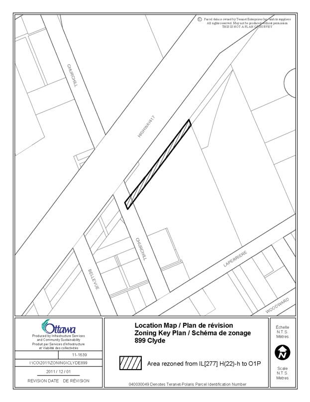
2. 899 Clyde Avenue
Ward 16
|
This property is zoned
IL[277] H(22)-h.
An error was made when
neighbouring properties were rezoned through By-law 2011-19, leaving the
strip of land shown in Document 4 zoned IL[277] H(22)-h. This property should have been rezoned O1P.
|
Amend the
Zoning Map for By-law 2008-250 for the property shown in Document 4.
Delete the zone
code IL[277] H(22)-h and replace with O1P.
|
|
3. 2499 and 2500 Palladium
Drive
211 and 225 Huntmar Drive
Ward 6
|
These properties are zoned
General Mixed-Use – GM22 H(12).
The former West Carleton
Zoning By-law contained provisions for the location of parking and display of
vehicles within the Palladium Auto Park.
These provisions were not completely carried forward to By-law
2008-250.
In order to more accurately
carry forward the provisions of the former zoning by-law and enable a
consistent design approach throughout the Auto Park, it is recommended that
Section 188, Table 188E be amended to permit 25% of a landscaped buffer
abutting a street to be used for the display of vehicles up to 1.5 m to the
street, and for the remainder of parking to be located no closer than 6.0 m
to the street.
|
Amend Section
188 of By-law 2008-250, Table 188E.
Under column II,
row (c) add the words “, except in the case of a parking space, which may be
located no closer than 6.0 m to any public street” so that the whole
provision reads:
-9.0 m, except
in the case of a parking space, which may be located no closer than 6.0 m to
any public street
Add a new row
(j).
Under column I,
row (j) add the words
-Parking space
location
Under column
II, row (j) add the words:
-Despite (i)
above and Section 110, Table 110(a), Location of Landscaped Buffer abutting a
street, each dealership may use up to 25% of its frontage for display of
vehicles which may be located no closer than 1.5 metres to any public street,
provided the balance of the frontage is landscaped
|
|
4. Section 192 – Mixed-Use
Centre Subzones
|
The Mixed-Use Centre – MC13
Subzone is no longer in use; therefore, it is recommended that it be deleted.
|
Amend
Subsection 192 (13) of By-law 2008-250 by deleting the text in its entirety
and replacing it with the following:
-Reserved for
Future Use
|
|
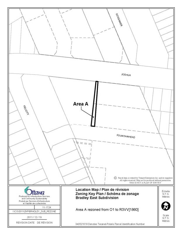
5. Bradley East Subdivision
Ward 2
|
The properties shown in
Document 4 are zoned, in part, O1 – Parks and Open Space.
Subsequent to Council
approval of Zoning By-law Amendment D02-02-11-0013 in July 2011, it has been
determined that the easterly portion of the O1 zone is not correctly aligned
with the abutting properties that are proposed as part of Plan of Subdivision
application D07-02-11-0002. In order
for the zoning boundary to more precisely follow the proposed property lines,
it is recommended that the portion of land shown in Document 4 be rezoned
from O1 to Residential Third Density – R3VV[1860].
|
Amend the
Zoning Map of By-law 2008-250 to rezone the properties shown in Document 4
from O1 to R3VV[1860].
|
|
6. Section 240, Exception
[720]
Ward 6
|
Exception [720] applies to
multiple properties on and in the vicinity of Westridge Drive in Stittsville.
Exception [720] is derived
from the former Goulbourn R1-5 zone, which established a minimum front yard
setback of 4.5 m to 6.0 m for interior lots and 6.0 m for corner lots. There was no maximum front yard setback in
the R1-5 zone.
Exception [720] erroneously
established a maximum front yard setback of 6.0 m for all lots, except those
that are pie-shaped. Furthermore, the
4.5 m minimum front and corner side yard setback provisions in the Exception
are redundant, as they are already defined as such in the parent R1Q zone.
Therefore it is recommended
that Exception [720] be amended in order to delete the redundant and maximum
setback provisions and re-establish the previous 6.0 m front yard setback for
a corner lot.
|
Amend Section
240 of By-law 2008-250, Exception [720].
Under Column V
– Provisions, delete the two provisions that read:
-minimum front
and corner side yard setbacks 4.5 metres, and:
-maximum front
yard setback 6.0 m, except in the case of pie-shaped lots.
Replace with:
-minimum front
yard setback for a corner lot is 6.0 metres.
|
|
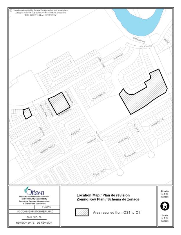
7. West of Greenbank Road
to Grand Canal Street, north of Cambrian Road, and north and south of River
Run Avenue
Ward 3
|
There is an error in the
zone code for the areas identified in Document 4.
The current zone code reads
OS1, which does not exist in By-law 2008-250.
The correct code is O1, which reflects the intended use of these lands
as parks.
|
Amend the
Zoning Map for By-law 2008-250 for the properties shown in Document 4.
Delete the zone
code OS1 and replace with O1.
|
LIST OF ANOMALIES AND MODIFICATIONS TO ZONING BY-LAW 2008-250 FOR
THE CONSIDERATION OF THE AGRICULTURAL AND RURAL AFFAIRS COMMITTEE DOCUMENT
2
|
Item
|
Objective of Amendment
|
Proposed Amendment
|
|
Zoning Map and Text Corrections
|
|
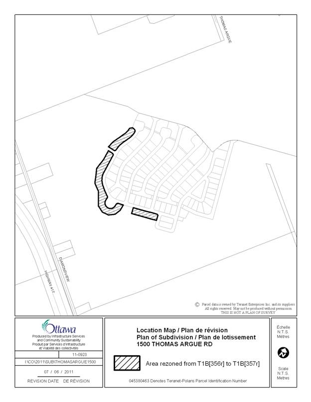
1. 1500 Thomas Argue Road
Ward 5
|
The properties identified
on Document 4 are all zoned Air Transportation Facility Zone- T1B[356r] and
form part of an approved draft plan of subdivision.
At the time the subdivision
and relevant zoning were approved, an error was made which incorrectly
assigned the wrong Rural Exception to these properties.
Therefore it is recommended
that the properties be rezoned so as to allow the appropriate development
standards to apply.
|
Amend the
Zoning Map of By-law 2008-250.
Rezone the
properties identified in Document 4 from T1B[356r] to T1B[357r].
|
|
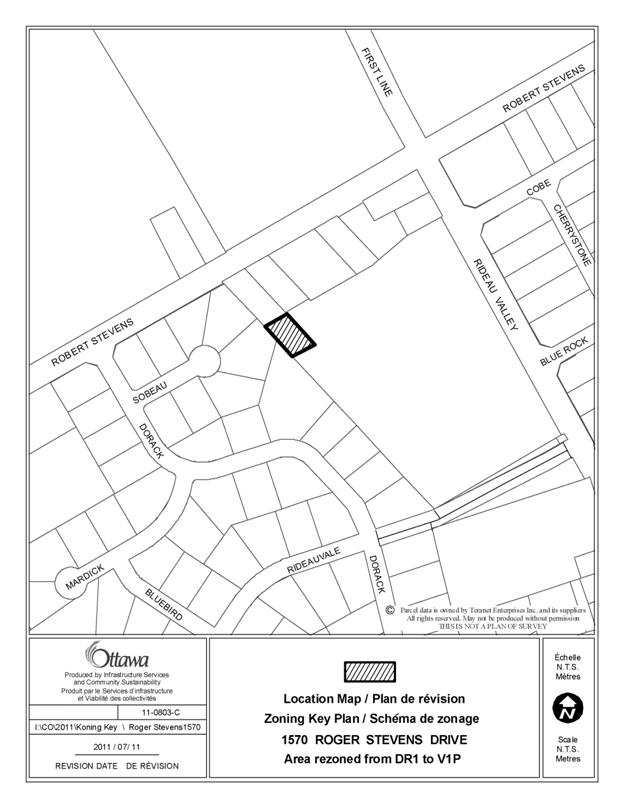
2. 1570 Roger Stevens Drive
Ward 21
|
This property is bisected
by Village First Density Residential and Development Reserve zones – V1P and
DR1. The portion that is zoned DR1 is
landlocked and surrounded by property zoned V1P.
As this portion of the lot
is landlocked, and therefore development as a seperate lot is not possible,
it is recommended that this portion is rezoned from DR1 to V1P to bring it
into conformity with the balance of the lot.
|
Amend the
Zoning Map for By-law 2008-250.
Rezone the
portion of the property located at 1570 Roger Stevens Drive from DR1 to V1P,
as shown in Document 4.
|
|
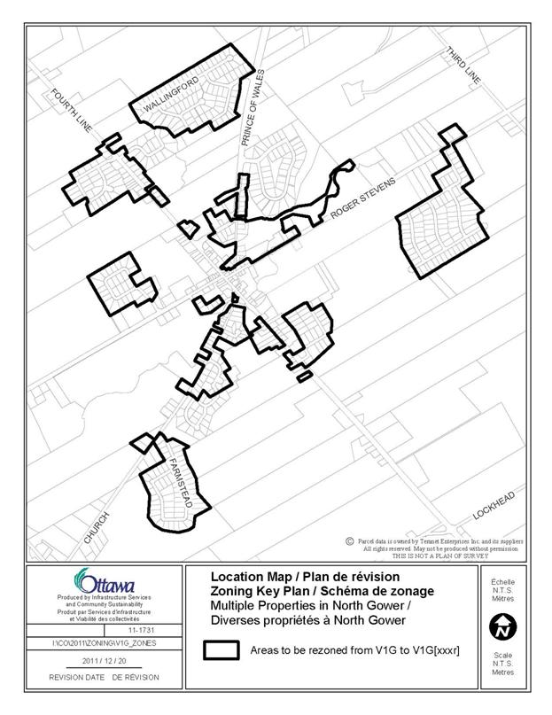
3. Multiple Properties in
North Gower
Ward 21
|
When By-law 2008-250 was
introduced, properties zoned R and RV under former Rideau By-law 2004-428
were rezoned to V1G – Village Residential First Density.
The V1G zone is
representative of the provisions of the former Rideau’s R zone and has a
front and a corner side yard setback requirement of 13.5 metres. However, the former RV zone only had a
front and corner side yard setback of 6.0 metres. Therefore the effect of including these
properties in the V1G zone has been to render them legally non-complying.
Where there was an
exception in place to the RV zone, that exception has been recognized through
an appropriate exception to the V1G zone in By-law 2008-250.
In order to remedy this
situation, it is recommended that those properties that were zoned RV (no
exception) be rezoned V1G[xxxr] to recognize the existing minimum 6.0 metre
front and corner side yard setbacks.
|
Amend the
Zoning Map of By-law 2008-250 to rezone those properties shown in Document 4
from V1G to V1G[xxxr].
Amend Section
240 of By-law 2008-250 to add Exception [xxxr]. Under Column II – Applicable Zone, add:
V1G[xxxr]
Under Column V
– Provisions add:
-minimum front
and corner side yard setbacks of 6.0 metres.
|
|
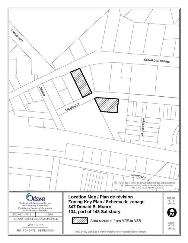
4. 347 Donald B. Munro
Drive
134 and 143 Salisbury Street
Ward 5
|
These properties are zoned Village
Residential Second Density – V2E.
The Community Design Plan
for the Village of Carp designates these lands “Residential - Ground Oriented
Multi-Unit”, which permits a range of residential uses including detached,
semi-detached, duplex, and ground-oriented multi-unit dwellings. The V2E permits detached, semi-detached,
duplex dwellings, and other uses.
When By-law 2008-250 was
introduced, some of the lands zoned R1 under the former West Carleton By-law
65/94 were designated V3B, in keeping with the policies of the Community
Design Plan. The subject properties were
erroneously designated V2E, which does not fully implement the land use
designation in the Community Design Plan.
In order to fully implement
the Community Design Plan for the Village of Carp as recommended by Council,
it is recommended that the
properties shown in Document 4 be
rezoned V3B.
|
Amend the
Zoning Map of By-law 2008-250 to rezone the properties shown in Document 4
from V2E to V3B.
|
|
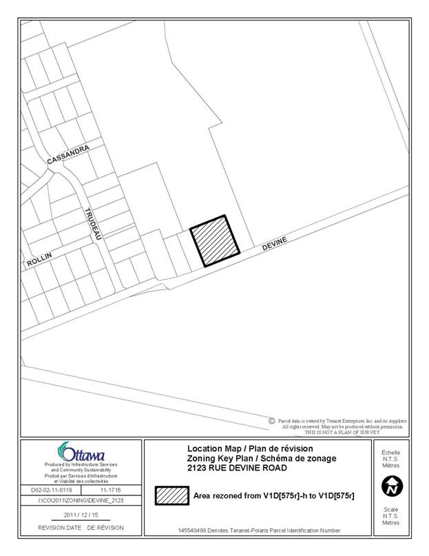
5. 2123 Devine Road
Ward 19
|
This property is zoned
Village Residential First Density – V1D[575r]-h.
In 2008 the holding provision was lifted from this
property with the approval of Lifting of Holding Zone file no.
D07-07-06-0006. However, when By-law 2008-250 was introduced the
Zoning Map did not reflect this approval.
In order to implement the approved zoning, it is recommended that
Zoning Map be amended by lifted the holding symbol from the subject property.
|
Amend the
Zoning Map of By-law 2008-250 to rezone the properties shown in Document 4
from V1D[575r]-h to V1D[575r].
|
|
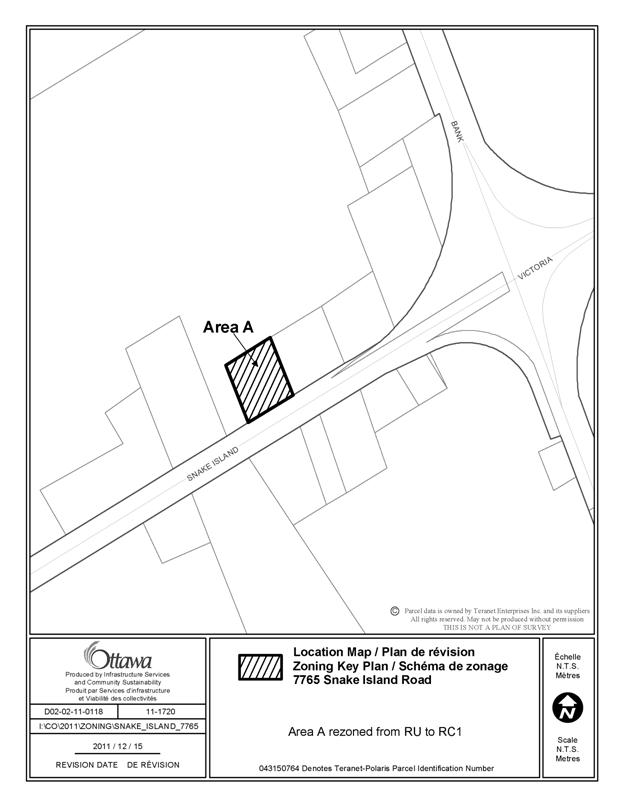
6. 7765 Snake Island Road
Ward 20
|
This property is zoned
Rural Countryside – RU.
The property was zoned
Highway Commercial – C2 in the former Osgoode Zoning By-law. With the introduction
of By-law 2008-250 adjacent properties were zoned RC1 – Rural Commercial but
the subject property did not maintain its Commercial zoning. In order to
carry forward the regulations of the former Osgoode Zoning By-law it is
recommended that the property be rezoned Rural Commercial – RC1.
|
Amend the
Zoning Map of By-law 2008-250 to rezone the properties shown in Document 4
from RU to RC1.
|
|
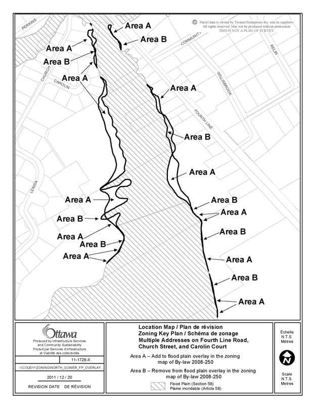
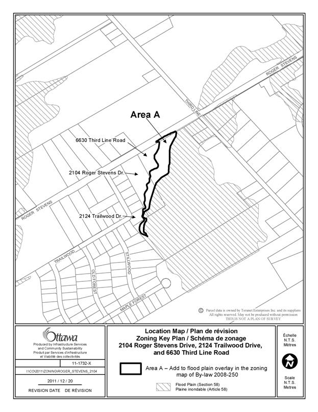
7. 6646, 6660, 6668, 6672,
6674, and 6720 Fourth Line
Road
2340, 2344, and 2348
Church Street
6652, 6654, 6656,
and 6658 Carolin Court
2104 Roger Stevens Drive
2124 Trailwood Drive
6630 Third Line Road
Ward 21
|
The
Flood Plain Hazard Overlay shown on the Zoning Map reflects the Stevens Creek
flood plain as defined by the Rideau Valley Conservation Authority.
Inaccuracies
have been found in the City’s Flood Plain Hazard Overlay, as it does not
match the Conservation Authority’s flood plain mapping in certain areas. It is recommended that the City’s Zoning
Map be amended accordingly.
|
Amend
the Zoning Map of By-law 2008-250 to show the new boundaries of the Flood
Plain Hazard Overlay for the maps shown in Document 4.
|
|
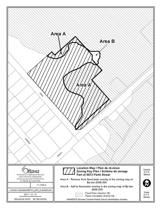
8. 5873 Perth Road
Ward 21
|
The current Flood
Plain Hazard Overlay zoning on this site is based on the flood plain
mapping of the Jock River prepared by the Rideau Valley Conservation
Authority (RVCA). In February 2010, an
application was submitted to the RVCA for approval to undertake a balanced
cut and fill on the site. This application (RV5-27/10T) was approved in
January 2011 and the work was undertaken thereafter.
Since the completion of the work a survey has been
submitted and the new grades have shown this area of the property to be above
the 1:100 year flood plain of Flowing Creek. The RVCA has revised its mapping
of the subject property to remove it from the flood plain designation. It
is recommended that the City’s Zoning Map be amended accordingly.
|
Amend
the Zoning Map of By-law 2008-250 to show the new boundaries of the Flood
Plain Hazard Overlay for the map shown in Document 4.
|