|
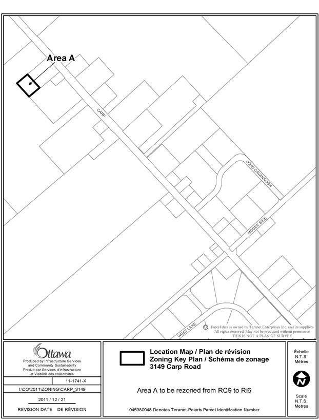
3. ZONING – PART OF 3149 CARP ROAD ZONAGE – PARTIE DU 3149, CHEMIN CARP |
COMMITTEE RECOMMENDATION
That Council approve an amendment to Zoning By-law 2008-250
to change the zoning of part of 3149 Carp Road from RC9 (Rural Commercial zone,
subzone 9) to RI6 (Rural Institutional zone, Subzone 6) as shown in Document 1.
RECOMMANDATION DU
COMITÉ
Que le Conseil approuve une modification au Règlement de
zonage 2008-250 en vue de faire passer le zonage d’une partie du 3149, chemin
Carp de R9 (Zone commerciale rurale, sous-zonee 9) à RI6 (Zone d’institutions
rurales, sous-zone 6), tel qu’illustré dans le document 1.
Documentation
1. Deputy City Manager’s Report, Planning and Infrastructure Services dated 15 February 2012 (ACS2012-PAI-PGM-0038).
Report to/Rapport au :
Agriculture and Rural
Affairs Committee
Comité de l'agriculture et des
affaires rurales
and Council / et au Conseil
15 February 2012 / le 15 février
2012
Submitted by/Soumis
par : Nancy Schepers, Deputy City Manager/Directrice
municipale adjointe, Planning and
Infrastructure/Urbanisme et Infrastructure
Contact
Person/Personne-ressource : Derrick Moodie, Manager/Gestionnaire, Development
Review-Rural Services/Examen des projets d'aménagement-Services ruraux,
Planning and Growth Management/Urbanisme et Gestion de la croissance
(613)
580-2424, 15134 Derrick.Moodie@ottawa.ca
|
SUBJECT: |
|
|
|
|
|
OBJET : |
REPORT
RECOMMENDATION
That the recommend Council approve an amendment to
Zoning By-law 2008-250 to change the zoning of part of 3149 Carp Road from RC9
(Rural Commercial zone, subzone 9) to RI6 (Rural Institutional zone, Subzone 6)
as shown in Document 1.
RECOMMANDATION
DU RAPPORT
Que le Comité de recommande au
Conseil d’approuver
une modification au Règlement de zonage 2008-250 en vue de faire passer le
zonage d’une partie du 3149, chemin Carp de R9 (Zone commerciale rurale,
sous-zonee 9) à RI6 (Zone d’institutions rurales, sous-zone 6), tel qu’illustré
dans le document 1.
BACKGROUND
The subject land is located on the west side of
Carp Road and north of McGee Side Road.
The site is currently vacant, surrounded by rural commercial uses, the
existing Huntley Presbyterian Cemetery to the northeast, vacant land to the
southwest and residential uses to the east.
In May 2011, a portion of 3155 Carp Road (0.35
hectares) was conveyed to 3149 Carp Road (the existing Huntley Presbyterian
Cemetery) in order to increase the land available for future use by the
cemetery (application D08-01-11/B-00138 and D08-01-11/B-00138).
Purpose of Zoning Amendment
The purpose of the amendment is to rezone the
lands from RC9 (Rural Commercial zone, subzone 9) to RI6 (Rural Institutional
zone, subzone 6) to permit the use of a cemetery on the vacant parcel. The proposed zoning matches the zoning of the
existing cemetery to which the subject lands will be combined with.
Existing Zoning
The current zoning of the parcel is RC9 (Rural
Commercial, subzone 9) under Zoning By-law 2008-250. This zone permits a limited range of
commercial uses including retail stores, animal care establishments and automobile
service stations. A cemetery is not a
permitted use in this zone.
Proposed Zoning
The requested zoning amendment proposes to
rezone part of the subject property from RC9 to RI6. This zone permits the use of a cemetery.
DISCUSSION
Official Plan
According to the Official Plan, the subject
land is designated Carp Road Corridor Rural Employment Area. The
intent of this designation is to
reserve land for rural industrial and commercial uses. All new development within this corridor must
conform to the policies in the Carp Road Corridor Community Design Plan (CDP).
The site is
designated as “Highway Commercial Area” in the CDP’s Land Use Plan (Schedule
1). The objective of the “Highway
Commercial Area” is to reserve land for uses that attract and serve passing
traffic and require direct access to arterial roads.
The proposed
amendment does not offend the intent of the designation as the rezoning is for
a conveyance of land to an existing cemetery.
Zoning By-law
The site is zoned RC9, which accommodates a
range of highway commercial uses for the Carp Road Corridor.
The proposed zoning (RI6) permits the use of a
cemetery. Currently the land is vacant;
however the land was conveyed to the existing Huntley Presbyterian Cemetery in
order for the cemetery to expand. With
the land conveyance, the cemetery will continue to meet the required RI6 zone
provisions.
RURAL IMPLICATIONS
The subject land will be used for the expansion
of the existing Huntley Presbyterian Cemetery and there will be no rural
implications.
CONSULTATION
Notice of this application was
carried out in accordance with the City's Public Notification and Consultation
Policy. The City did not receive any
negative comments or opposition to this application.
COMMENTS BY THE WARD COUNCILLOR
The Ward Councillor is aware of this
application and the staff recommendation.
LEGAL IMPLICATIONS
There are no legal implications associated with
this report.
RISK
MANAGEMENT IMPLICATIONS
There are no risk management implications associated with this report.
FINANCIAL IMPLICATIONS
There are no financial implications associated
with this report.
ACCESSIBILITY
IMPACT
ENVIRONMENTAL IMPLICATIONS
There are no environmental issues associated
with this report.
TECHNOLOGY IMPLICATIONS
There are no direct technical implications
associated with this report.
CITY STRATEGIC PLAN
There are no City strategic plan implications
associated with this report.
APPLICATION PROCESS TIMELINE STATUS
This application was not
processed by the "On Time Decision Date" established for the
processing of Zoning By-law amendment applications.
SUPPORTING DOCUMENTATION
Document 1 Location
Map
DISPOSITION
City Clerk and Solicitor Department,
Legislative Services to notify the owner, applicant, OttawaScene Canada Signs, 1565
Chatelain Avenue, Ottawa, ON K1Z 8B5,
Ghislain Lamarche, Program Manager, Assessment, Financial Services Branch (Mail
Code: 26-76) of City Council’s decision.
Planning and Growth Management to prepare the implementing by-law,
forward to Legal Services and undertake the statutory notification.
Legal Services to forward the implementing
by-law to City Council.
LOCATION MAP DOCUMENT
1