Report to/Rapport au:
Planning and Environment Committee
Comité de l'urbanisme et de l'environnement
and Council / et au Conseil
04 November 2010 / 04 novembre 2010
Submitted by/Soumis par : Nancy Schepers, Deputy City Manager/Directrice municipale adjointe, Infrastructure Services and Community Sustainability/Services d’infrastructure et Viabilité des collectivités
Contact Person/Personne-ressource : Richard Kilstrom, Acting Manager/Gestionnaire intérimaire, Development Review-Urban Services, Inner Core/Examen des projets d'aménagement-Services urbains, Unité du Centre intérieur
Planning and Growth Management/Urbanisme et Gestion de la croissance
(613) 580-2424, 22379 Richard.Kilstrom@ottawa.ca
|
SUBJECT: |
|
|
|
|
|
OBJET : |
REPORT RECOMMENDATIONS
That the recommend Council approve an amendment to the Zoning By-law 2008-250 to change the zoning of 154 O’Connor Street from R5B[482] F(3.0) (Residential Fifth Density Subzone B, Exception 482, Floor Space Index 3.0) to R5B[xxxx] F(3.0) (Residential Fifth Density Subzone B, Exception xxx, Floor Space Index 3.0) to permit a restaurant and to permit a commercial parking lot as a temporary use for a period of three years, as shown in Document 1, and as detailed in Document 2.
RECOMMANDATIONS DU RAPPORT
Que le Comité de l’urbanisme et de l’environnement recommande au Conseil d’approuver une modification au Règlement général de zonage no 2008-250 afin de changer le zonage du 154, rue O’Connor, de R5B[482] F(3.0) (Zone résidentielle de densité 5, sous-zone B, avec exception 482, dotée d’un rapport plancher-sol de 3,0) à R5B[xxxx] F(3.0) (Zone résidentielle de densité 5, sous-zone B, avec exception xxx, dotée d’un rapport plancher-sol de 3,0), en vue de permettre un restaurant et un terrain de stationnement commercial comme utilisations temporaires pour une période de trois ans, comme le montre le document 1 et l’explique le document 2.
BACKGROUND
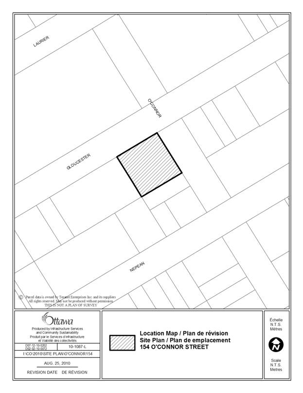
This site is located at 154 O’Connor Street, on the southwest corner of O’Connor Street and Gloucester Street. The 913-square metre site currently contains a decommissioned gas station, with frontage on O’Connor and Gloucester Streets of 30 metres. The site is surrounded by the 21‑storey Esplanade Laurier to the north, mid to high-rise residential buildings to the east across O’Connor Street, a convenience store to the south and a surface parking lot and two-storey office building to the west.
Existing Zoning
The site is zoned R5B[482] F(3.0) “Residential Fifth Density Subzone B”, which has a Floor Space Index of 3.0 and an exception that permits a restaurant and other service retail uses on the ground floor or basement of a residential use building.
Purpose of Application
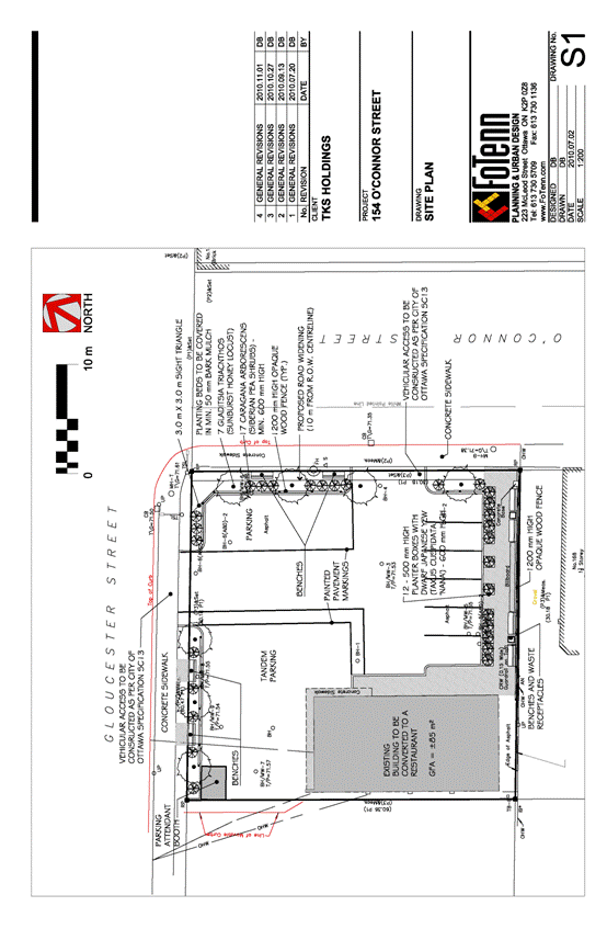
The application proposes to retain the existing building and convert it into a restaurant use and add a commercial parking lot of approximately 26 vehicles, as shown on the concept plan (Document 3). An amendment to the Zoning By-law is required in order to permit the proposed development.
Proposed Zoning
Staff recommend the following changes to the zoning that applies to the site:
· Permit a stand-alone restaurant that is in the existing building;
· Permit a parking lot as a temporary use for a three year period;
· Require the parking lot to be in association with another commercial use;
· Reduce the width of landscaped buffer for a parking lot to 1.2 metres adjacent a street and 0 metres adjacent the property to the west.
The complete details of the recommended zoning are included in Document 2.
DISCUSSION
Planning Act and Provincial Policy Statement
Section 2 of the Planning Act outlines those land use matters that are of provincial interest, to which all City planning decisions shall have regard. The provincial interests that apply to this site include the appropriate location of growth and development and the promotion of development that is designed to be sustainable to support public transit and to be oriented to pedestrians. In addition, the Planning Act requires that all City planning decisions be consistent with the Provincial Policy Statement (PPS), a document that provides further policies on matters of provincial interest related to land use development. PPS policies indicate that opportunities for redevelopment should be promoted on brownfield sites and where there are existing services.
The proposed zoning allows this brownfield site to be re-used in its present form until such time that it can be redeveloped with a more intense land use, thereby efficiently using existing services. The proposed commercial use will be accessible to pedestrians and transit. Staff conclude that the proposal is consistent with the matters of provincial interest as outlined in the Planning Act and PPS, while acknowledging that the future redevelopment of the lands with more intense residential uses will satisfy additional provincial interests, such as the location of intensification and the mix of uses.
Official Plan
Land Use Designations
The site is designated as “General Urban Area” on Schedule B of Volume 1 of the Official Plan. To facilitate the development of complete and sustainable communities, the General Urban Area is intended to develop with a full range and choice of housing, in combination with conveniently located employment, retail, service, cultural, leisure, entertainment and institutional uses. The Official Plan requires that uses that serve wider parts of the city will be located at the edges of neighbourhoods on roads where the needs of these land uses, such as transit, access and parking can be more easily met and their impacts controlled. Parking lots will be considered when their visual impact on adjacent uses and from the street are minimized.
The site is located at the northern edge of Centretown adjacent to the Central Area, thus the proposed development acts as a transition between the two areas. O’Connor Street is a southbound arterial road that serves as a main egress route from the city’s Central Area, which provides good access for the proposed use. The addition of a restaurant fits well within the General Urban Area designation given the proximity to the Central Area and the convenient service it provides to the surrounding communities. Given that the site was previously used as a gas station, the re-use as a restaurant and commercial parking lot represents an improvement. Furthermore, the proposed parking lot use is to be limited to a temporary three-year term to set the stage for redevelopment of the site that is more in conformity with the Official Plan direction. The site is proposed to include additional landscaping, including street trees and benches, which adequately mitigate the visual impact of the parking lot.
Centretown Secondary Plan
The Centertown Secondary Plan in Volume 2 of the Official Plan intends to conserve and enhance the residential character of Centertown as an inner city community with several identifiable neighborhoods focused around defined commercial corridors and public open spaces. The land use schedule defines land use designations reflective of the desired use and built form patterns. These designations are intended to serve as a framework within which the objectives and policy directions are to be achieved.
The site is situated immediately south of the Central Area and as such is designated as “High Profile Residential” on Schedule H of the Centretown Secondary Plan. In general, residential areas shall include dwelling uses and may include public service and minor retail and office uses which serve primarily the local population but are not necessarily limited to only the geographic area of Centretown. The plan indicates that in general, the development of new public parking will not be permitted. The plan’s site development policies specify that all parking and loading areas shall be appropriately landscaped and screened from adjacent properties and roadways.
The proposed restaurant is a use that will primarily serve the local area as well as the Central Area in general. The proposed development also serves as a transition from the residential area to the south and the commercial area to the north. Although parking lots are not encouraged, the proposed parking lot is more desirable than the former gas station at this location. It should also be noted that the proposed development is an interim use until such time that the land is redeveloped with more intense land uses that better realize the vision of the Centretown Secondary Plan. The current landowner also owns the adjacent surface parking lot property to the west, and has indicated that the intent is to develop the two properties together. Staff encourage the co-ordination of development of the two sites in a orderly manner. The addition of a restaurant with an outdoor patio partly compensates for the temporary parking in improving the street animation.
Mid-Centretown Community Design Plan
The site is within the study area of the Mid-Centretown Community Design Plan (CDP), which is targeted for completion in early 2011. Because the outcome of this CDP, and its implications for this site, are as yet unknown, the future development plans for the site are still in flux. As a result, it is reasonable to consider a temporary parking lot use in light of the fact that the site will be improved through landscaping and providing a more pedestrian-oriented restaurant use.
Compatibility and Design
Sections 2.5.1 and 4.11 of the Official Plan outline the objectives and policies for compatible development. The surrounding development is largely commercial in nature, with residential located across O’Connor Street to the east. The proposed development includes landscaping and setbacks that respect adjacent uses and provide a transition/buffer. The landscaping also provides for an improved streetscape which contributes to the overall improvement of the community. Traffic impacts will be reduced as the proposed use generates less traffic than the previous gas station use, and due to the reduction in the number of vehicular entrances to the site. Vehicles and pedestrians are adequately separated on site to avoid conflicts between the two, and improve conditions on the site. Thus, it is demonstrated that the proposed development satisfies the compatibility tests of the Official Plan in a way that does not result in undue adverse impacts.
The Segregated Bike Lane Project will create a designated bike lane on one or more Centretown or Central Area streets, and is anticipated to result in the removal of some existing on-street parking spaces. The proposed development removes one access and reconfigures the remaining accesses to the site, resulting in the addition of approximately five (5) on-street parking spaces on O’Connor and Gloucester Street. This will provide additional on-street parking after the Segregated Bike Lane Project is implemented in 2011.
Downtown Ottawa Urban Design Strategy
The application is within the area subject to the Urban Design Review Panel. This type and form of development is exempt from review by the Panel.
Temporary Use and Zoning By-law
The parking lot is proposed to be permitted only as a temporary use for a three-year period ending in November 2013. Given that the proposed parking lot use does not satisfy the long-term vision for the site, and given that staff desire to ensure that the owner seeks redevelopment, it is recommended that the use only be permitted on a temporary basis.
In addition, the proposed zoning will include special provisions pertaining to this specific development proposal. The parking lot is only permitted on a lot with another primary use, which ensures that it will not be a stand-along parking lot. A maximum number of tandem parking spaces is also proposed in order to limit the extent of the parking lot. The accompanying concept plan (Document 3) proposes a landscaped strip approximately 2.5 metres wide (1.2 metres on private lands, 1.3 metres on road allowance) between the parking lot and the sidewalk, which is an improvement over the present situation with no landscaping. The parent R5B (Residential Fifth Density Subzone B) residential zoning will remain and will apply to future redevelopment, and the provisions from the existing exception 482 will be carried over to the new exception.
Site Plan Control
Site issues such as stormwater servicing, landscaping details and access will be addressed through the concurrent Site Plan Control process.
Summary
The proposed re-use of the brownfield site supports the direction of the Planning Act and Provincial Policy Statement by efficiently using existing serviced lands. The proposed development represents a transition between the Central Area and Centretown, includes a restaurant use that serves the surrounding community, and provides a better situation than the previous use. The proposed temporary parking lot is limited to a temporary three-year period, which will encourage future development that is expected to be more in keeping with long-term direction of the applicable plans. In light of the above, staff recommend approval of the proposed Zoning By-law amendment.
ENVIRONMENTAL IMPLICATIONS
Phase I and II Environmental Site Assessments (ESA) were submitted with the application. Certain conditions will be included in the Site Plan Control approval based on the recommendations of the ESA and review by City staff.
RURAL IMPLICATIONS
CONSULTATION
Notice of this application was carried out in accordance with the City's Public Notification and Consultation Policy. The City did not receive any negative comments or opposition to this application.
COMMENTS BY THE WARD COUNCILLOR(S)
26 October 2010:
I support the conversion of the former gas station into a restaurant because it will animate this section of O'Connor Street. However, I do not support the re-zoning of the balance of the land for a commercial parking lot, with tandem parking likely. Once entrenched as a commercial parking lot, providing mostly long-term commuter parking as these lots generally do, their potential for redevelopment as per the Official Plan goals is much less likely.
LEGAL/RISK MANAGEMENT IMPLICATIONS
There are no legal/risk management implications associated with this report.
CITY STRATEGIC PLAN
The proposed development aligns with the City Strategic Plan in that it respects the existing urban fabric, neighbourhood form, and the limits of existing hard services so that new growth is integrated seamlessly with established communities.
TECHNICAL IMPLICATIONS
FINANCIAL IMPLICATIONS
There are no direct financial implications associated with this report.
APPLICATION PROCESS TIMELINE STATUS
This application was processed by the "On Time Decision Date" established for the processing of Zoning By-law amendment applications.
SUPPORTING DOCUMENTATION
Document 1 Location Map
Document 2 Details of Recommended Zoning
Document 3 Concept Plan
Document 4 Consultation Details
DISPOSITION
City Clerk and Solicitor Department, Legislative Services to notify the owner, applicant, OttawaScene.com, 174 Colonnade Road, Unit #33, Ottawa, ON K2E 7J5, Ghislain Lamarche, Program Manager, Assessment, Financial Services Branch (Mail Code: 26-76) of City Council’s decision.
Planning and Growth Management to prepare the implementing by-law, forward to Legal Services and undertake the statutory notification.
Legal Services to forward the implementing by-law to City Council.
LOCATION MAP DOCUMENT 1
DETAILS OF RECOMMENDED ZONING DOCUMENT 2
Proposed Changes to the Comprehensive Zoning By-law
1. The Zoning Map of City of Ottawa Zoning By-law 2008-250 is amended by changing the zoning of the lands known municipally as 154 O’Connor Street from R5B[482] F(3.0) to R5B[xxxx] F(3.0);
2. Add a new exception R5B[xxxx] F(3.0) to Section 239 with provisions similar in effect to the following:
Column III: Additional land uses permitted:
personal service business, limited to barber shop, beauty parlour, or dry cleaner's distribution station
place of assembly, limited to a club
retail store limited to a drug store, florist shop, news stand,
restaurant
parking lot
Column V: Provisions
a) additional permitted uses, other than a parking lot or place of assembly limited to a club are only permitted:
i. on the ground floor or basement of a building containing dwelling units; and
ii. in the existing single-storey building.
b) despite Table 110, the minimum required width of landscape buffer for a parking lot:
i. abutting a street: 1.2 metres
ii. where the lot line abuts an existing parking lot on an adjacent lot: 0 metres
c) for a principal use parking lot, tandem parking and attendant parking are permitted
d) subsection 85(3) does not apply
e) a building or structure accessory to a principal use parking lot shall have a minimum front yard setback of 1.2m, and a minimum interior side yard setback of 0.0m
f) a principal use parking lot is only permitted on a lot with another permitted use that is located in the existing single-storey building.
g) a principal use parking lot is permitted only as a temporary use effective November 24, 2010 and expiring November 23, 2013.
CONCEPT PLAN DOCUMENT 3
CONSULTATION DETAILS DOCUMENT 4
NOTIFICATION AND CONSULTATION PROCESS
Notification and public consultation was undertaken in accordance with the Public Notification and Public Consultation Policy approved by City Council for Zoning By-law amendments. No comments were received from the public.