O'Keefe Drain Environmental Management Plan
The Study
City of Ottawa Council approved the O'Keefe Drain Environmental Management Plan on June 12, 2013.
The objectives of the plan are to:
- Consider the impacts and develop a plan to mitigate adverse affects of existing and proposed land uses on natural areas and the O'Keefe Drain
- Establish a stormwater management plan for future development
- Protect, enhance, or restore the natural system
Study Area
The study area is the portion of the O'Keefe Drain catchment area situated between Strandherd Drive, Highway 416, the Jock River and Cedarview Road. The study area is completely within Ward 3 – Barrhaven, though the O'Keefe Drain does extend into Ward 21 – Rideau-Goulbourn.

Process
The O'Keefe Drain Environmental Management Plan is a Master Plan following Phases 1 and 2 of the Municipal Class Environmental Assessment (Class EA). The Master Plan identifies the stormwater management infrastructure requirements for future development areas within the area bounded by Fallowfield Road, Strandherd Drive, Highway 416 and the Jock River.
Recommendations
The EMP made recommendations related to:
- Stormwater management
- Realignment and width of the channel corridor
- Erosion mitigation
- Aquatic habitat
- Culvert upgrades
- Woodlot preservation
Public Consultation
Consultation, in the form of technical advisory committee meetings and a public open house were incorporated as part of the class environmental assessment process and are documented in the Environmental Management Plan.
For more information please contact
Kalle Hakala
Planner II
Planning and Growth Management
Infrastructure Services and Community Sustainability
City of Ottawa
110 Laurier Avenue West, 4th Floor
Ottawa, ON, K1P 1J1
Tel: 613-580-2424, ext. 16228
Fax: 613-580-2459
E-mail: kalle.hakala@ottawa.ca
Village of Carp Environmental Management Plan
City of Ottawa Council approved the Community Design Plan (CDP) for the Village of Carp on July 14, 2004, providing a comprehensive land use plan that will guide how the village grows over the next twenty years. A key recommendation of the CDP was that an Environmental Management Plan (EMP) be prepared for the village to determine environmental and stormwater management measures to mitigate the impacts of this growth.
Council approved the Village of Carp Environmental Management Plan on May 25, 2005.
Recommended measures to protect the village’s environmental features are:
- Continue to preserve and protect the Carp Hills Natural Environment Area (NEA) and promote stewardship to ensure long-term health of the NEA.
- An Environmental Impact Statement will be required for all new development, including new lot creation, within 30 meters of the Carp Hills NEA.
- Vegetative cover using native species will be established and enhanced in the setback/buffer area through conditions of development approval and encouraged through stewardship programs in existing developed areas.
- Development applications will be accompanied by an integrated environmental review statement, demonstrating how all the studies in support of the application influence the design of the development with respect to effects on the environment and how it complies with the appropriate policies of Section 4 of the Official Plan.
- Through the development process, any affected Carp River corridor lands (i.e., floodplain, hazard lands, etc.) should be dedicated into public ownership and recreational linkage opportunities explored. See the Carp River Watershed Study.
- Protect the Carp River Corridor through the Village and prepare a restoration plan for the riparian corridor.
- Where possible, through the development process, tributary nos. 1 and 2 and their associated corridors should be dedicated into public ownership.
For further information, please contact:
Darlene Conway, P. Eng
Planning and Infrastructure
110 Laurier Avenue West, 4th Floor
Ottawa ON K1P 1J1
Tel: 613-580-2424 x27611
Fax: 613-580-2578
Nicholas Stow
Planner III
Planning and Infrastructure
110 Laurier Avenue West, 4th Floor
Ottawa ON K1P 1J1
Tel: 613-580-2424, ext. 13000
Fax: 613-580-2459
Village of Constance Bay
The City has prepared an Environmental Management Plan (EMP) for the proposed new residential development areas identified in the Community Plan for the Village of Constance Bay. The EMP followed the Master Plan approach of the Class Environmental Assessment process. Recommendations pertaining to natural environment protection, watercourse setbacks and potential enhancement measures, stormwater management design criteria and conceptual stormwater management solutions are included in the EMP.
The preliminary findings of the EMP study were presented along with the draft Community Plan and the results of the Constance Bay Groundwater Study at an Open House held on February 4, 2006. The findings from the Groundwater Study have been incorporated into the EMP. Additional field studies pertaining to the terrestrial environment were undertaken in the spring and early summer of 2006.
The final Constance Bay EMP report was approved by Committee and Council in 2007 with subsequent filing for public review. Highlights from the EMP can be viewed in the staff report to Committee and Council. For more information on this study, please contact:
Darlene Conway, Eng.
Senior Project Manager
Planning, Transit and the Environment Department
City of Ottawa
110 Laurier Ave. West, 4th Floor
Ottawa, ON K1P 1J1
Tel: 613-580-2424 ext. 27611
Fax: 613-580-2578
Or
Amy MacPherson
Natural Systems Planner
Planning and Growth Management Department
City of Ottawa
110 Laurier Ave. West, 4th Floor
Ottawa, ON K1P 1J1
Tel: 613-580-2424 ext. 14873
Fax: 613-580-2459
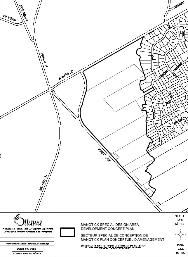
Village of Manotick
Study area boundary – jpeg 119 KB
Concept plan
A Concept Plan has been completed to guide future development within the area designated as ‘Special Design Area’ (SDA) in the Village of Manotick Secondary Plan. The study area is bounded by Mud Creek on the east, Bankfield Road on the north, and First Line Road on the west. The Concept Plan determines such things as land use pattern, servicing, stormwater management, parks, road network and environmental features.
Environmental management plan
The City has prepared an Environmental Management Plan (EMP) for the Special Design Area, including a natural environment plan and stormwater management plan. The EMP followed the Master Plan approach of the Class Environmental Assessment process. Recommendations pertaining to natural environment protection, watercourse setbacks and restoration, stormwater management design criteria and conceptual stormwater management solutions were developed in the Plan.
The Special Design Area EMP was presented at an Open House held on April 18, 2006. The recommendations from this study have been incorporated into the Concept Plan. The Village of Manotick Environmental Management Plan – Special Design Area Component (March 2005) was completed based on analysis and input from technical agencies. The report is available for viewing at the Manotick Library and the Ben Franklin Place Client Service Centre.
For more information on these studies, please contact:
Nicholas Stow
Planner III
Planning and Growth Management
Infrastructure Services and Community Sustainability
110 Laurier Avenue West, 4th Floor
Ottawa ON K1P 1J1
Tel: 613-580-2424, ext. 13000
Fax: 613-580-2459
Village of Richmond environmental management plan
Ottawa City Council approved the Community Design Plan (CDP) for the Village of Richmond on July 14, 2010, providing a comprehensive land use plan that will guide how the village grows over the next twenty years. Several supporting plans were also approved at the same time: a Master Servicing Study, a Transportation Master Plan, and an Environmental Management Plan (EMP). The EMP was prepared to determine environmental and stormwater management measures to mitigate the impacts of the proposed village growth, and to identify opportunities for environmental enhancement of the public lands along the Jock River.
The EMP made recommendations in four subject areas:
- Policies and constraint mapping (incorporated into the community design plan)
- Stormwater management strategies
- Improvements to strengthen the recreational opportunities and connection of the Village to the Jock River
- Stewardship and partnerships on public and private property
A key component of the EMP is the agreement between the City and the Rideau Valley Conservation Authority (RVCA) to carry out capital improvements and maintenance of the public lands at the Richmond Conservation Area and along the Jock River. The RVCA will undertake various projects on City-owned properties other than parks, to enhance visitor experiences while still protecting the natural features and functions of the river corridor. The work will begin in 2011 using special levy funding.
For further information about the EMP, please contact:
Lise Guèvremont
Natural Systems Planner
Planning and Growth Management Department
City of Ottawa
110 Laurier Ave. West, 4th Floor
Ottawa, ON K1P 1J1
Tel: 613-580-2424 ext. 13797
Fax: 613-580-2459
For information about the RVCA’s projects, please contact:
Kristy Giles
Conservation Lands Planner
Rideau Valley Conservation Authority
PO Box 599
3889 Rideau Valley Drive
Manotick, ON K4M 1A5
Tel: 613-692-3571 ext. 1178
Fax: 613-692-0831
East Urban Community
The City of Ottawa has prepared an Environmental Management Plan (EMP) to support the Community Design Plan (CDP) for Phase 2 of the East Urban Community. The Phase 2 study area is bounded by the CPR railway tracks to the south, Renaud Road to the north, Mer Bleue Road to the east and Phase 1 of the CDP to the west.
The Environmental Management Plan was prepared as a Master Plan under the Municipal Class Environmental Assessment (EA) process. The EA process was initiated in October 2005. Four public information sessions were held on: October 26th, 2005, to present an overview of existing conditions and the planning process; on April 20th, 2009 to provide an update on the study’s progress; on June 23, 2009 to present the alternative stormwater management solutions considered and identify the preferred alternative; and on December 11, 2012 to present the alternative stormwater management designs considered and identify the preferred design, along with the draft demonstration plan for the community.
The EMP also identifies natural heritage system features in and adjacent to the study area and recommends measures for their protection during future development. Notable features include the Notre-Dame-des-Champs Woods, the Sabourin Creek corridor, and the Mer Bleue Wetland to the south of the study area.
Ottawa City Council approved the CDP, the EMP and an associated infrastructure plan update in October 2013.
For more information on the Environmental Management Plan, contact:
Amy MacPherson
Planner II
Planning and Growth Management
Infrastructure Services and Community Sustainability
City of Ottawa
110 Laurier Avenue West, 4th Floor
Ottawa, ON K1P 1J1
Phone: 613-580-2424, ext. 14873
Fax: 613-580-2459