Overview
On July 17, 2013, following a two-year pilot project, Council approved the permanent installation of separated bike lanes on Laurier Avenue West.
The bike lanes will largely remain in their current configuration (separated from motor vehicles using temporary concrete curbs) until the street is due for reconstruction, expected sometime after 2018. When Laurier Avenue West is reconstructed, the separated bike lanes will be converted to raised cycle tracks.

Pilot Project Background and Permanent Approval
The project was initiated in 2008 when Council approved the Ottawa Cycling Plan (OCP). Council directed staff to pilot a downtown east-west on-street dedicated cycling lane separated by a median from regular traffic. This direction was given in the context of the vision and goals of the OCP, which include the following:
- To triple the number of person-trips made by bicycle
- To make cycling safer for cyclists of all skill and age levels
- To link, connect and expand existing cycling facilities.
In February 2011, after a technical evaluation of all potential east-west downtown routes, Council directed staff to implement the pilot project on Laurier Avenue West. Following this, staff engaged in a period of consultation and engagement with local businesses and residents to address any concerns with the design.
The segregated bicycle lanes were opened on July 10, 2011. Throughout the two-year pilot project staff undertook monitoring over a wide range of indicators to assess the bike lane's usage and the impact on other travellers as well as residents and businesses. In response to public feedback several minor design improvements were made throughout the project.
In November 2011, Council approved funding for the East-West Bikeway as part of the Ottawa on the Move initiative. The East-West Bikeway is a 12 kilometres bicycle route between Westboro and Vanier which utilizes the segregated bicycle lanes along Laurier Avenue West. The East-West bikeway route provides improved connections to Laurier Avenue West, improving the utility of the segregated bike lane section.
In fall 2012, staff provided an update report to Transportation Committee and Council that highlighted the first year of the performance monitoring results for the pilot project. Key indicators confirmed significant increases in cycling activity along Laurier Avenue with more than triple the amount of cycling trips compared to before the bicycle lanes were implemented. The update also provided encouraging results for other indicators as well, including collision data, emergency response times, and maintenance efforts.
In summer 2013, staff reported to Transportation Committee and Council following the conclusion of the two-year pilot period. The report documented the results of the monitoring program and the impacts of bike lanes across a range of indicators. In summary, the results of the monitoring program indicate that the bicycle lanes have achieved their main objectives of significantly increasing bicycle traffic and cycling mode shares within the downtown area. Other key indicators include: improved road safety with fewer reported collisions and fewer near-collisions; minimal impact to motor vehicle operations; parking and loading mitigation opportunities; no impacts to emergency response times; and feedback from cyclists, residents, businesses and other road users.
The Report also identified both short- and long-term improvements to Laurier Avenue West to address some of the issues identified through the pilot project. Short term improvements focused on providing additional street parking and a new section of raised cycle track at the western end to better connect with the Albert Street multi-use pathway. The longer term recommendation is to convert the separated bicycle lanes to raised cycle tracks when the street is reconstructed sometime post-2018.
On July 17, 2013, Council approved the permanent installation of the bike lanes on Laurier Avenue and directed staff to consult with the public as part of the design process to reconstruct Laurier Avenue West to include raised cycle tracks. Following Council's decision to make the lanes permanent, the project won the 2015 Sustainable Communities Award in Transportation from the Federation of Canadian Municipalities.
Laurier Ave – Safety Review
The Laurier Segregated Bike Lane Safety Review was initiated in October 2016 by the Transportation Services Department. The review concluded in August 2017 and focused on the safety of cyclists, pedestrians and motorists travelling through the Laurier Avenue corridor between Bronson Avenue and Elgin Street. The evaluation of the corridor included a collision history review, a bicyclist behaviour study at intersections, a human factors (i.e. human abilities, limitations and characteristics) review, a public on-line survey, the evaluation of potential countermeasures, and the development of proposed recommendations.
A Laurier Avenue Segregated Bike Lane Working Group was developed to provide input and feedback throughout the review process. The Working Group was comprised of representatives from Bike Ottawa (Citizens for Safe Cycling), the EnviroCentre, the Environmental Stewardship Advisory Committee (ESAC), the Transportation Services Department, Safer Roads Ottawa and Mobycon, a Dutch based consulting firm hired to complete the study. This working group was instrumental in the development of the Laurier Corridor Safety Review Report.
The results of the Laurier SBL Safety Review showed that since the opening of the segregated lanes in 2011, there was a 330% increase in the number of cyclists using the segregated bike lane. . The comparison of collisions during the four (4) years prior to, and the four (4) years following the implementation of the segregated lanes shows positive results. Collisions involving pedestrians declined by 50%, the collision rate involving cyclists was reduced by 30% and there was a 10% reduction in the number of motor vehicle collisions.
The review confirmed that safety has increased along the corridor and that users are adapting to segregated bike lanes. The cyclist behaviour study found that conflicts between cyclists and motor vehicles continues to decline in number and in severity.
Since the Laurier Safety Review concluded in August 2017, the following recommended safety measures have been implemented by the City of Ottawa along the Laurier – Bronson to Elgin corridor:
- All green thermoplastic cross-rides and bike boxes refreshed;
- Offset stop bars at all intersection approaches where right turns are permitted;
- All flex posts replaced or upgraded through entire corridor;
- Green thermoplastic installed across all private entrances between Metcalfe and Elgin;
- Separate bike signal heads installed at all intersections, with a 5-second advance simultaneous with the advanced pedestrian phase (motorists receive a red ball during this period); and,
- “Right turning vehicles yield to cyclists” signs relocated onto mast arm next to vehicle signal heads.
Along with these measures, staff are currently reviewing existing signage along the corridor with the goal of removing/relocating some signs around the intersections to help reduce clutter and driver workload. The green thermoplastic across private entrances will continue to be added in the blocks west of Metcalfe as funding is available and the existing curbs are also being reviewed to determine where they can be extended at driveways to tighten the turning radii.”
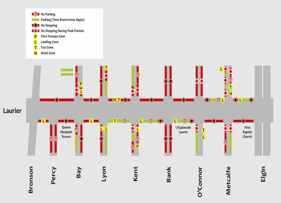
Accessible Pick-up / Drop-off Locations along Laurier Avenue West
This information is provided to assist with the pick-up and drop-off of individuals with physical challenges along Laurier Avenue West.
The key map [ JPG - 106 KB ] indicates the preferred accessible pick-up and drop-off locations along Laurier Avenue for each of the scenarios described below.
Para Transpo
Para Transpo can pick-up or drop-off clients at the following locations:
- Private Property (taxis sedans only)
- Para Transpo Zones
- Loading Zones
- No Parking Zones
- No Stopping Zones (without impeding traffic)
- On-street parking spaces (limited ramp access)
Accessible Parking Permits
Vehicles with a valid Accessible Parking Permit can pick-up or drop-off at the following locations:
- Private Property (requires permission)
- Loading Zones
- No Parking Zones
- No Stopping Zones (without impeding traffic)
- On-street parking spaces (limited ramp access)
Vehicles without an Accessible Parking Permit
Vehicles without an Accessible Parking Permit can pick-up or drop-off at the following locations:
- Private Property (requires permission)
- Loading Zones
- No Parking Zones
- On-street parking spaces (limited ramp access)
Frequently asked questions
How was Laurier Avenue selected?
- Laurier Avenue West was selected as the location for the segregated bike lane for a number of reasons, including: Highest number of cyclists of any east-west corridor within in the study area
- Traffic signals at every intersection, which provide for a safe route
- Proximity to several major destinations such as City Hall, main public library, Confederation Park, central business district, schools, high-density residential dwellings
- Convenient connections to the Transitway, University of Ottawa, Sandy Hill, the ByWard Market, Gatineau, Lebreton Flats, Chinatown, and the Glebe
- Excellent connections to other bicycle facilities, including: the NCC pathways along the Ottawa River and Canal; existing bike lanes along Percy St., Bay St., Lyon St., and over the Laurier Avenue Bridge (which connects to Nicholas St.); and the existing bike-friendly staircases near Cambridge St. that connect to the neighbourhoods to the west of the escarpment
- No bus routes
- No curb side garbage pick-up
- High volume of vehicle traffic, so segregation would increase cyclist safety and comfort
- Plenty of off-street parking lots in the vicinity, with additional capacity for new on-street parking along adjacent and nearby parallel streets, thereby minimizing the impact of the pilot project in the area
- Opportunity to revitalize the commercial street frontage, as the bike lanes will draw in continuous activity during evenings and weekends, hence promoting the extension of commercial activities that currently focus on the demands of weekday office workers
Were residents and businesses consulted?
Extensive consultations with residents, community groups, businesses and other stakeholders have taken place, and their feedback was incorporated into the design of the bike lanes wherever possible. The City continues to work with all stakeholders who may be impacted to make sure that the community needs are addressed to the fullest (within the broader context of the overall project). This is a pilot project and the City will continue to monitor and encourage people to provide feedback on how this project can be improved.
Where can people supposed to park now?
On-street parking has increased in the area, particularly along the side streets, while 44 parking spaces still remain on Laurier. For every space that was removed from Laurier, an additional space was added to Gloucester and Nepean Streets, which are only a block or two away. Unlike the previous parking spaces on Laurier which were limited to off peaks hours, these new spaces are available throughout the day, some for free. Additional information about on-street parking changes in the area is available online.
It should also be noted that additional bike parking has been implemented along Laurier, with dozens of new ring and post facilities installed between Bronson Avenue and Elgin Street.
How are business drop-offs and deliveries accommodated?
Emergency vehicle access, access to off-street loading zones and access to a building’s
entry and parking garage have all been maintained as is the case with hotel and taxi zones. On-street loading zones were placed in close proximity to their previous locations with the additional and three were added to improve access to businesses along the corridor.
What is the impact on local businesses?
Extensive research indicates that businesses typically benefit from facilities such as these, especially from the increased number of cyclists who are more likely to stop on their way compared to motorists. A summary of this research is available online [ PDF 290 KB ].
Why no right turns on red lights?
This facilitates the implementation of left-turn bike boxes that would conflict with right turning vehicles on red lights. It increases safety for the high levels of pedestrians and cyclists along the corridor.
How will travel in the bike lane be enforced?
Bylaw and police will monitor the use of the bike lane to see if conflicts or safety issues occur. Other motorized vehicles, like mopeds, remain strictly prohibited and will be ticketed and fined for using the lane.
Who is not allowed to use the segregated bike lane?
- Pedestrians
- Anyone operating a motorized vehicle that is not classified as a bicycle under the Highway Traffic Act
How does a segregated bike lane differ from a shared or multi-use pathway?
Multi-use or shared pathways such as those along the Canal and the Ottawa and Rideau rivers are not regulated under the Ontario Highway Traffic Act. In Ottawa, these off-road facilities are where pedestrians, cyclists, rollerbladers, and personal mobility devices are all permitted and expected to share the path. Off-road path users are typically required to yield at driveway and access lanes while bike lane users have the legal right-of-way.
What should I do if I see a vehicle blocking the bike lane?
Please call the City at 3-1-1 immediately. By-law staff will respond as required. You may also report it as part of our online service requests.