Overview

South Nepean town centre community design plan [PDF 3.08 MB]
This document is the Council approved guide to the long-term growth and development of the South Nepean Town Centre. The Community Design Plan provides guidelines for the day-to-day decision-making on land use planning and sets out the community's priorities for the future.
Section 1.0 Introduction
1.1 Study Area
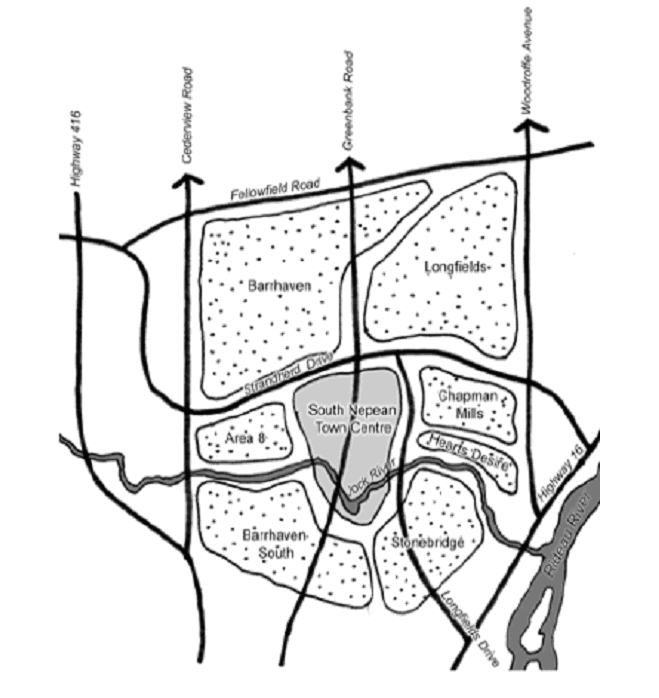
The South Nepean Town Centre is an area of approximately 165 hectares in size located in the southern portion of the City of Ottawa’s urban area. The Town Centre’s northern boundary is Strandherd Drive, its western boundary is the Kennedy-Burnett Stormwater Management Facility, its eastern boundary is the future extension of Longfields Drive, and its southern boundary is the Jock River. The established residential communities of Barrhaven and Longfields surround the Town Centre to the north; the partially developed Chapman Mills community and established Heart’s Desire community is adjacent to the east; the existing Stonebridge community is to the southeast; the proposed Barrhaven South community is to the southwest; and the undeveloped “Area 8” lands are to the west.
The large majority of the study area is currently undeveloped. The Barrhaven Town Centre and RioCan Marketplace, large-format retail projects to the west and east of Greenbank Road, respectively, have been substantially completed along Strandherd Drive and St. Joseph Secondary School was recently constructed along Greenbank Road. There are existing residences along Greenbank Road, both in the centre of the Town Centre and further south adjacent to the Jock River. Existing farm operations and commercial businesses make up the remainder of land uses within the Town Centre. The study area is largely comprised of unwooded field areas, with the exception of wooded areas immediately surrounding the Jock River.
1.2 Background
The former City of Nepean initiated a detailed visioning exercise for the Town Centre in the early 1990s. Resulting from this exercise, Nepean City Council endorsed the Nepean South Urban Activity Centre Concept Design Report in 1994 as the vision for the Town Centre’s future development. Subsequently, Nepean undertook an integrated planning program, including transportation, servicing, environmental, and land use planning studies that resulted in the adoption of the Area 7 Secondary Plan by Nepean City Council in 1997. The Secondary Plan established land use policies, residential densities, built form requirements and urban design guidelines. The Area 7 Secondary Plan has remained as the statutory planning document guiding development within the Town Centre since its approval in 1997, after being readopted by the City of Ottawa in 2002 and reconfirmed in the Official Plan (May 2003), Volume 2A.
However much has changed since the approval of the Area 7 Secondary Plan in 1997. Several significant large-format retail projects have been constructed along Strandherd Drive, a new land use policy direction was established in the Official Plan with a particular emphasis on urban design, and new strategic directions for rapid transit routes have been established for the Town Centre. The emergence of these issues necessitated the preparation of an updated land use and design vision for the Town Centre.
The South Nepean Town Centre Urban Design Strategy was initiated in 2004 to provide this updated vision. The Urban Design Strategy outlines the goals and objectives, describes the land use structure plan and its structuring elements, identifies a series of urban design principles to follow, and provides direction for implementation. The Urban Design Strategy was completed in 2005 and was the visioning document that guided the preparation of the South Nepean Town Centre Community Design Plan (CDP). The Urban Design Strategy is not considered planning policy.
The Town Centre CDP was prepared based on the recommendations of the Urban Design Strategy. As part of the Town Centre CDP process, some modifications to the Strategy’s land use vision were required to account for new street and transit alignments that were provided by several Environmental Assessment (EA) studies after the completion of the Strategy. These EA studies provided more detailed direction for Chapman Mills Drive (North-South Light Rail EA), Greenbank Road (Greenbank Road EA), Longfields Drive (Jockvale-Longfields Extension EA), and the Southwest Transitway corridor (Southwest Transitway Extension EA). These modifications to the Town Centre structure were made in keeping with the overall vision presented by the Urban Design Strategy.
1.3 Planning Context
The majority of the Town Centre is designated as a Mixed-Use Centre within the Official Plan, with an overlay Town Centre designation that has additional policies related to higher employment targets. The South Nepean Town Centre is one of the three such areas in Ottawa. Town Centres are key components of the City’s growth management strategy and are to act as focal points of activity for the broader community. They are strategically located adjacent to the future rapid transit network and major streets and intended to be mixed-use, walkable, pedestrian-scaled, and transit-supportive communities, with a particular attention to high quality urban design.
The Official Plan requires the completion of a community design plan for all Town Centres. CDPs are intended to translate the policies and direction of the Official Plan to the community level by, among other things, analyzing the existing conditions of the community, defining specific objectives for the housing and land use mix, establishing targets for affordable housing, greenspace and transit, presenting a detailed development land use plan, outlining urban design principles and guidelines, providing guidelines for development review, and providing a detailed implementation strategy. The key components of the South Nepean Town Centre CDP will be approved by Amendment to the Official Plan as a Secondary Plan and will provide direction for future development through the land use planning process.
1.4 Components of the CDP
The CDP is comprised of seven components:
- Section 2.0 – provides a set of goals and objectives that give the general direction and intent for the
Town Centre. - Section 3.0 – provides the structuring elements around which the Town Centre is organized.
- Section 4.0 – establishes the land use plan and land use policy areas that detail the intent, permitted
uses, and policies of different areas within the Town Centre. - Section 5.0 – outlines the urban design policies and guidelines that will achieve the urban design vision for the Town Centre.
- Section 6.0 – outlines the intent and policies for the transportation network of streets, public transit and cycling routes within the Town Centre.
- Section 7.0 – outlines the intent and policies for the service network of water supply, wastewater, and
stormwater management to service development within the Town Centre. - Section 8.0 – describes how the vision and plan for the Town Centre will be implemented.
Section 2.0 Goals and Objectives
The foundation of the South Nepean Town Centre CDP is a set of goals and objectives that provide the framework for future development in the Town Centre, based on the Urban Design Strategy. The goals and objectives expressed in Sections 2.1 to 2.6 are not prioritized and are overlapping, thus they must be considered together when making land use and design decisions regarding the Town Centre.
2.1 Goal 1 – Compact Urban Form
Goal: Development that reflects a dense, compact and transit-supportive built form.
Objectives:
- To develop a focal point within South Nepean to provide a common identity and focus for surrounding communities;
- To support the viability of transit by coordinating land use, transportation infrastructure and urban design in a mutually complementary manner;
- To facilitate the development, intensification, and redevelopment of the Town Centre in an urban fashion, including buildings, streetscapes and open spaces; and
- To provide flexibility for the use of land, including opportunities for retail and office commercial, residential, institutional and community buildings.
2.2 Goal 2 – High Quality Urban Design
Goal: High-quality urban design for all development, both public and private.
Objectives:
- To achieve high quality urban design for development that reflects the role of the Town Centre as South Nepean focus;
- To create a strong community image by enhancing the character of the built environment including building design and massing, signage, and planting;
- To provide a transition between areas with different densities within the Town Centre and also between the Town Centre and adjacent lower density communities;
- To develop attractive streetscapes during the design of the public realm, built form, streetscapes and other public areas; and
- To encourage the use of ‘green’ technologies in the design of new buildings and infrastructure.
2.3 Goal 3 – Mixture of Land Uses
Goal: Provision of a broad range of retail, office, institutional, and residential uses.
Objectives:
- To promote the development of a mixed-use area to create an attractive working and living atmosphere;
- To provide a variety of low-rise, mid-rise and high-rise building forms in order to provide different household types with housing choices;
- To provide an adequate supply of affordable housing for moderate-income and low-income households within the Town Centre;
- To ensure that residential and non-residential uses are compatible and complementary to each other;
- To encourage the establishment of social services, parks, public facilities and public transit services in locations which are conveniently accessible; and
- To provide a sufficient number of employment opportunities within the Town Centre to enable residents in South Nepean to work within the community.
2.4 Goal 4 – Diverse Greenspace Network
Goal: Provision of a diverse greenspace network.
Objectives:
- To establish a range of recreation opportunities to meet the needs of the resident and worker population;
- To design parks and open spaces to complement a compact, urban environment;
- To develop a pedestrian and bicycle network that connects parks, public buildings, stormwater management areas, local streets, the Jock River and surrounding communities; and
- To protect the ecological health and integrity of the Jock River and surrounding natural features.
2.5 Goal 5 – Efficient Transportation System
Goal: Provision of an efficient, multi-modal transportation network.
Objectives:
- To incorporate rapid transit routes within a compact, urban built environment in order to increase public transit ridership and to reduce traffic congestion, energy costs and pollution.
- To develop a grid of continuous and interconnected arterial, collector and local streets and laneways facilitating efficient movement by all modes of transportation.
- To develop a pedestrian-friendly, tree-lined, and bicycle-friendly system of streets that is well connected to public facilities, parks, commercial areas and surrounding communities.
- To provide a system of on-street parking to support ground floor uses, particularly retail commercial uses, while avoiding large surface parking areas.
2.6 Goal 6 – Anticipation of Growth
Goal: A logical progression of development from initial phases to a mature state reflecting the envisioned urban form.
Objectives:
- To permit interim forms of development to occur while protecting for the achievement of the Town Centre’s ultimate built form; and
- To ensure that infrastructure improvements are comprehensively planned to address the needs of development within the Town Centre; and
- To ensure that the City promotes and participates in the early development of the public realm, including public buildings, high order transit services, on-street parking, and urban squares and plazas; and
- To ensure that the establishment of the Town Centre as a transit focal point for South Nepean is maintained and protected.
Section 3.0 Community Structure
The foundation for the land use plan in the Town Centre CDP was set by the community structure plan in the Urban Design Strategy, which provided the guiding vision as to how the Town Centre should develop over the long-term. The five structuring elements in Sections 3.1 through 3.5 provide the framework around which the Town Centre is organized.
3.1 Transit
Public transit in the Town Centre is organized to meet the transit modal-split and transit-oriented development objectives of the Official Plan and Transportation Master Plan. Two rapid transit routes are planned within the Town Centre. The light rail transit (LRT) route will operate in an east-west direction, extending westwards from the Chapman Mills community within the central lanes of Chapman Mills Drive, with landscaped medians to the divide the route from other vehicular traffic. Mixed-use areas will be located along the length of Chapman Mills Drive within the Town Centre. The bus rapid transit (BRT) will enter the Town Centre from the north, across Strandherd Drive, and will operate in a north-south direction. Building design along the BRT route is intended to incorporate the route as much as possible. The Transitway is planned to be at grade, except where it passes under Strandherd Drive. The transit “hub” is located where these two rapid transit routes intersect, and is to be a very accessible, and therefore, highly desirable location for higher density forms of development and major community facilities.
3.2 Greenspace
Greenspace is organized to assist in achieving the vision of the Town Centre as an urban community that is characteristically different from the surrounding suburban communities. Greenspace elements will be designed as key aesthetic and functional components to complement the anticipated higher intensity forms of development. The Jock River is incorporated as the basis of the greenspace network with a large natural park along its length within the Town Centre and with the adjacent street network structured to provide access and views. Neighbourhood parks will be designed as urban squares, with more hard surfaced areas and passive uses than conventional suburban parks. Public and private plazas will provide a complementary role to the streetscape and surrounding built form. Stormwater management facilities are intended to be community features with particular attention to landscape design and public accessibility. These greenspaces will be linked together through a continuous pedestrian and bicycle network, both on-street and off-street, that also connects to other communities in South Nepean.
3.3 Density
The Town Centre is planned to be a compact, urban area within the broader South Nepean community. The Town Centre is organized to provide an appropriate transition between the higher density uses within the Town Centre and the lower density uses in surrounding communities. The highest density buildings will be located around the transit hub and along Greenbank Road north of Chapman Mills Drive. The middle density buildings are located along the edges of the community adjacent to the highest density buildings, so as to provide an appropriate transition between these buildings and the primarily residential neighbourhoods within the Town Centre. The lowest density uses are located along the south edge of the Town Centre to provide an appropriate interface with the Jock River and the community park, preserving views and vistas.
3.4 Streets

Streets establish the basic form and pattern of development in the Town Centre, and thus are a critical component for achieving the built form objectives. A highly integrated and fine-grained system of streets, based on a grid pattern, serves three different roles. First, streets will integrate different neighbourhoods within the Town Centre through co-ordinated streetscaping efforts of sidewalks, street trees and landscaping, and rear lanes. Second, streets will connect the Town Centre with surrounding residential communities through different routes and street hierarchy types. Third, streets will organize a pattern of regular blocks that can accommodate a wide range of uses and built forms and allows for future intensification and redevelopment.
3.5 Blocks

The street network creates a development block pattern that is conducive to the desired urban built environment. The block pattern within the Town Centre is organized around development blocks that are between 1.0 and 2.0 hectares in size and approximately 80 metres in depth, dimensions that will accommodate a variety of different land uses and building types envisioned. While all of the identified design objectives and density targets will not be met in the short and mid-term, it is expected that over the long-term through redevelopment and intensification these objectives and targets can be met. Given that street patterns are more enduring once they are established, the grid pattern of streets must be adhered to from the outset in order to ensure a block pattern that is flexible and conducive to achieving the CDP’s design objectives over time.
Section 4.0 Land Use
The land use policies in this Section set the framework for land use planning within the Town Centre. Based on these policies, the Town Centre could accommodate over 22,000 residents and over 12,000 employment opportunities (see Tables 2 and 3) at ultimate build-out. The success of the Town Centre will not be judged in the short term, but will be determined in the long-term timeframe when the ultimate build-out as envisioned by this CDP would occur.
Table 1 – Land Use Distribution
| Policy Area | Net Area (hectares) | % of Total Area |
|---|---|---|
| High Rise Mixed-Use | 26.5 | 16.1% |
| Mid Rise Mixed-Use | 34.2 | 20.7% |
| High Rise Residential | 3.4 | 2.1% |
| Mid Rise Residential | 21.9 | 13.2% |
| School | 7.9 | 4.8% |
| Civic Complex | 2.2 | 1.3% |
| District Park | 21.6 | 13.1% |
| Neighbourhood Park | 4.5 | 2.7% |
| Streets | 42.8 | 25.9% |
| Total | 165.0 | 100.0% |
Table 2 – Dwelling Type Distribution
| Dwelling Type | # of Dwellings | % of Total Dwellings |
|---|---|---|
| Phase 2 | ||
| Street Townhouses | 1,000 | 14% |
| Stacked Townhouses | 750 | 10% |
| Apartments | 5,500 | 76% |
| Total | 7,250 | 100% |
| Phase 3 | ||
| Street Townhouses | 1,000 | 9% |
| Stacked Townhouses | 750 | 7% |
| Apartments | 9,300 | 84% |
| Total | 11,050 | 100% |
Table 3 – Land Use Statistics
| Phase | Retail Gross Floor Area (m2) | Office Gross Floor Area (m2) | # of Dwelling Units | Population | Employment |
|---|---|---|---|---|---|
| Phase 1 – Initial | 78,000 | 1,000 | 0 | 0 | 1,000 |
| Phase 2 – Interim | 208,250 | 158,250 | 7,250 | 14,500 | 7,300 |
| Phase 3 – Ultimate | 217,000 | 350,500 | 11,000 | 22,500 | 12,600 |
Notes:
- Tables 2 and 3 indicate projections of different build out scenarios. Given the long-term nature of the scenarios, these figures should only be considered as potential build out projections based on permissions by the policies in this CDP.
- Numbers for each phase are total, not cumulative.
- Phase 1 does not include the limited residential units currently within the Town Centre.
- The type of units identified in Table 2 are intended to only illustrate the intensity of units, and not necessarily limit the form of units.
4.1 General Land Use Policies
The land use plan contained in Schedule 1 is comprised of eight land use policy areas, described in Sections 4.2 through 4.9. These policy areas identify the intent, permitted uses, and land use policies for specific areas of the Town Centre. The general land use policies in this Section apply to all eight policy areas within the Town Centre.
Policies
For all lands within the Town Centre:
- The “Generally Permitted Uses” in Section 3.1 of the Official Plan are permitted in all of the policy areas. Additionally, all municipal facilities and utilities shall be permitted in all land use policy areas.
- Parking standards will be determined by the Zoning By-law and will be guided by Section 6.4 (7).
- Affordable housing targets for residential developments are expressed in Section 8.6.
- The density targets identified in Sections 4.2 through 4.6 are ultimate build out targets and are to be considered on an area basis and not by each development block. While these targets may not be achieved from the outset, it must be demonstrated, as per Section 8.3, how these targets could be met in the long-term timeframe.
- The urban design policies and urban design guidelines in Section 5.0 apply to all development, subject to Sections 4.2(7) and 4.3(5).
- The following uses are not permitted, except for sites within the “Strandherd Retail District” that have existing zoning or master site plan permissions permitting such uses:
- Individual retail uses in stand-alone buildings with ground floor plates greater than 5,750 square metres;
- Gas stations;
- Drive-through facilities; and,
- Retail uses that require outdoor storage, with the exception of a seasonal garden centre ancillary to another permitted retail use.
- Private plazas will be encouraged for all private sector developments. Their actual size, configuration and design will be subject to confirmation by the City during the approval process. Private plazas:
- Include a range of forms, such as patios, terraces, and courtyards;
- Will not be used as part of parkland dedication;
- Will not be designated as separate open space blocks on the land use plan; and
- Will be encouraged to be surrounded by built form edges and be connected with landscaped mid-block connections or pedestrian mews.
4.2 Policy Area – High Rise Mixed-Use
The High Rise Mixed-Use policy area represents the primary retail and mixed-use development area within the Town Centre. The High Rise Mixed-Use policy area will be a lively and active mixed-use shopping district, with an emphasis on commercial and residential uses in the same building with retail uses located at-grade, but also single use retail and office commercial uses and residential apartments.
Policies
For the High Rise Mixed-Use policy area:
- Apartments, a broad variety of retail, office and service commercial activities, public and institutional uses, schools, places of worship, and community facilities are permitted.
- The minimum building height is 6 storeys and the maximum building height is 12 storeys.
- The net density target for residential uses is 250 units per hectare.
- The maximum lot coverage for stand-alone residential buildings is 30% of the total area of any block.
- All building frontage along Greenbank Road and Chapman Mills Drive must have non-residential uses at grade.
- The City will encourage that all buildings along the BRT route north of Chapman Mills Drive incorporate the route as much as possible into the design of the building, through such means as clear windows or secondary doors.
- The above policies in Section 4.2 or the policies and guidelines of Section 5.0 do not apply to future development in the “Strandherd Retail District” that is permitted by existing zoning or master site plans, provided that this development does not jeopardize the long-term acquisition of the public streets identified on Schedule 2 or public parkland identified on Schedule 5. For this new development, the City will still encourage the consideration of the urban design policies and guidelines in Section 5.0, as they may apply, during the development review process.
4.3 Policy Area – Mid Rise Mixed-Use
The Mid Rise Mixed-Use policy area represents a lower scale, mixed-use area within the Town Centre with the intent of establishing opportunities for live-work units and medium density housing forms. The Mid Rise Mixed-Use policy area is intended to be a transition between the High Rise Mixed-Use policy area and the adjacent lower density residential neighbourhoods, both within the Town Centre an in surrounding communities.
Policies
For the Mid Rise Mixed-Use policy area:
- Apartments, live-work units, retail, office and service commercial uses, public and institutional uses, schools, places of worship and community facilities are permitted.
- The minimum building height is 4 storeys and the maximum building height is 6 storeys.
- The net density target for residential uses is 200 units per hectare.
- The maximum lot coverage for stand-alone residential buildings is 50% of the total area of any block.
- The above policies in Section 4.3 or the policies and guidelines of Section 5.0 do not apply to future development in the “Strandherd Retail District” that is permitted by existing zoning or master site plans, provided that such development does not jeopardize the long-term acquisition of the public streets identified on Schedule 2 or public parkland identified on Schedule 5. For this new development, the City will still encourage the consideration of the urban design policies and guidelines in Section 5.0, as they may apply, during the development review process.
4.4 Policy Area – High Rise Residential
The High Rise Residential policy area identifies sites within the Town Centre that will accommodate the highest density residential uses, located in proximity to the transit “hub”. Apartment buildings will be the only residential type permitted.
Policies
For the High Rise Residential policy area:
- Apartments are the only permitted use. As part of an apartment building, retail, office and commercial uses at grade are also permitted.
- The minimum building height is 6 storeys and the maximum building height is 12 storeys.
- The net density target for residential uses is 300 units per hectare.
- At least 90% of required parking for each development must be provided in parking structures, either above-grade or below-grade.
4.5 Policy Area – Mid Rise Residential
The Mid Rise Residential policy area is intended to accommodate the majority of the Town Centre’s ground-oriented multiple unit dwellings. This policy area will provide an appropriate transition between the low density neighbourhoods surrounding the Town Centre to the higher intensity uses within it.
Policies
For the Mid Rise Residential policy area:
- Apartments, street, block and stacked townhouses, public and institutional uses, schools, places of worship and community facilities are permitted. Ground floor retail uses within a mixed-use building with residential uses above are permitted along Greenbank Road.
- The minimum building height is 2 storeys and the maximum building height is 4 storeys.
- The net density target for residential uses is 100 units per hectare.
4.6 Policy Area – Neighbourhood Park
The Neighbourhood Park policy area will include both public parks and public plazas. The five public parks within the Town Centre will be designed to support the area’s urban nature, as accessible amenities with open frontages and clearly defined entrances that work within the grid pattern of streets and blocks. The two public plazas within the Town Centre will be designed as predominately hard surfaced areas fronted by buildings in order to create a built form edge and generate pedestrian activity.
Policies
For the Neighbourhood Park policy area:
- Public parks, public plazas, community facilities, and conservation uses are permitted.
- The locations of the five public parks and the two public plazas are identified on Schedule 5 of this CDP.
- Acquisition of all neighbourhood parks will be as per Section 8.4 and Schedule 5 of this CDP.
- Public parks must:
- Generally be between 0.4 and 1.0 hectares of level land;
- Have at least three sides that are entirely open to the street;
- Not have rear or side yards adjacent on their fourth side;
- Be designed with an emphasis on hard surfacing and seating areas as compared to traditional suburban neighbourhood parks; and
- Not contain sports fields.
- Public plazas must:
- Generally be less than 0.4 hectares of level land;
- Be landscaped with street trees and other vegetation and include seating areas with furniture;
- Be considered as locations for public art;
- Be designed with an emphasis on hard surfacing and seating areas as compared to traditional suburban neighbourhood parks; and
- Not accommodate sports fields or traditional suburban play amenities.
4.7 Policy Area – District Park
The District Park policy area will accommodate the establishment of “Half Moon Bay Park”, a large and natural park that is focused on passive recreation areas, but with some opportunities for active recreation uses. Half Moon Bay Park will extend the entire width of the Town Centre along the Jock River and is intended to be a focal point of the greenspace system in the area, connecting with existing and future greenspace components in surrounding communities.
Policies
For the District Park policy area:
- Public parks, conservation management and control uses, trails, walkways and bicycle paths, educational facilities, sports fields and recreational facilities, existing uses as per Section 4.7(4), and buildings accessory to other permitted uses are permitted. Active recreation facilities such as sports fields are also permitted as long as the general intent of this park is maintained.
- For the design of Half Moon Bay Park:
- Pedestrian crossings of the river will be clearly defined;
- Vehicular access will be limited to certain points and parking will be provided in small pods with significant landscaping;
- The use of permeable surfaces for any hard-surfaced areas will be investigated;
- Internal streets will be designed to be rural in character;
- Public works will be located outside of natural features unless it is demonstrated that there is no reasonable alternative and then only if such works meet the requirements of the Official Plan; and
- All uses will be designed to ensure limited disruption to natural features and an Environmental Impact Statement is required to establish the appropriate development buffer from any identified natural features on the site.
- The City will work with the Conservation Authority, local interest groups, and interested advisory committees in the creation of a continuous, interconnected trail system and the protection and rehabilitation of identified natural features within Half Moon Bay Park.
- Existing homes and commercial operations within the Community Park policy area are recognized as conforming uses, as per Section 3.3(4) of the Official Plan. Landowners have the right to improve the properties in conformity with the existing zoning standards on the property. The City intends to acquire these properties as per Section 8.4(9) of this CDP.
- Half Moon Bay Drive will be designed as a “parkway” type of street, as per Section 6.2, with development only on its north side to ensure the preservation of views and vista of the park and the Jock River.
4.8 Policy Area – School
The School policy area will primarily accommodate school uses, but also can accommodate other community uses. The School policy area provides the opportunity to locate facilities that will serve an important role in attracting people to the Town Centre, thus generating a high level of social activity.
Policies
For the School policy area:
- Schools, community facilities, and places of worship are permitted.
- The minimum building height is 2 storeys and the maximum building height is 6 storeys.
- The alternative policy area for the site west of Greenbank Road is Mid Rise Residential if the site is not utilized for its intended purpose.
4.9 Policy Area – Civic Complex
The Civic Complex policy area will accommodate the development of a multi-purpose civic facility that will serve the broader South Nepean community. The facility is located directly adjacent to the transit hub and together with the central public plaza and surrounding buildings will be the civic focus of the Town Centre.
Policies
For the Civic Complex policy area:
- As part of a multi-purpose civic complex, a range of community uses is permitted, such as ice pads, swimming pools, courts, day cares, community halls, theatres, museums, libraries, or public health space, in addition to retail and office uses through joint arrangements with private sector partners.
- The civic complex is intended to be urban in form, with buildings constructed close to the street and a majority of required parking accommodated in structured parking.
- The minimum building height is 2 storeys and the maximum building height is 6 storeys.
- The alternative policy area for the Civic Complex site is High Rise Mixed-Use if the site is not utilized for its intended purpose.
Section 5.0 Urban Design
High quality urban design within the Town Centre will be critical for achieving an urban environment with a compact built form, a wide range of different uses, a convergence of high order transit routes, and a strong civic identity for South Nepean. The framework for urban design within this CDP consists of both urban design policies and urban design guidelines. Appendix C graphically illustrates the potential ultimate build out of the Town Centre based on the urban design policies and guidelines in this Section. Appendix D illustrates this potential for the different phases of the Strandherd Retail District’s evolution.
5.1 Urban Design Policies
The following urban design policies apply to all development within the Town Centre, except where certain design policies would contradict Section 4.2(7) and 4.3(5) regarding the Strandherd Retail District. They express the general objectives covering broader issues that must be met by all development. The policies are general in nature to permit flexibility during the design process while ensuring a minimum urban design standard is met.
Policies
- Buildings must maximize the coverage of lots.
- Buildings must be at least two fully functioning storeys in height, with different areas having greater minimum building heights as per Section 4.0.
- Buildings must be functionally and visually oriented to the public street and sited to be parallel to the public street and generally aligned with neighbouring buildings.
- Principal building entrances must be oriented to the public street and not to rear parking areas or lanes.
- Building design must address issues of adequate sunlight, sky views, and wind conditions.
- Buildings must be developed with a substantial portion of any visible front façade from a public street within 5.0 metres of the respective property line.
- Building frontage must be maximized along all public streets.
- At-grade uses must be flush with grade and provide an active use at grade in order to promote pedestrian activity.
- Spaces between the building wall and the street must provide an appropriate transition from the private realm to the public realm.
- Buildings must have dynamic façades with limited areas of blank, featureless walls.
- All parking, including surface, below-grade, and above-grade, must not detract from the aesthetic appearance of any public streetscape.
- Buildings and structures located at key locations must be designed and massed to emphasize their locations.
5.2 Urban Design Guidelines
The urban design guidelines provide specific design guidance on particular issues and elements within the Town Centre. The design guidelines are not considered a “design checklist”, but instead are to be applied on a case-by-case basis. While not considered policy, the City will use these guidelines during the review of development applications.
5.2.1 Built Form
Guideline 1: Orient principal entries to the primary street, so that they are connected to the sidewalk and are clearly identifiable through architectural features or signage.

Guideline 2: Orient buildings to face all parks, plazas and natural areas so as to “frame” these spaces and to allow visual access into these spaces for safety and security.

Guideline 3: Locate the buildings on corner sites close to both public streets and ensure that the level of architectural detailing on both flanking sides is consistent and includes windows and primary doors. Widen boulevards at corners to provide enhanced sidewalks conditions that include decorative planting areas, seating areas and other amenities. Wherever possible, locate the primary entrance at the corner of the two streets.
Guideline 4: Step the upper storeys of taller buildings back from the front lot line to minimize the impacts of taller buildings on the streetscape, such as shadowing and wind acceleration. For instance, step the building 2.0 metres above the 4th storey and another 2.0 metres above the 8th storey.


Guideline 5: Provide a smooth transition in height and massing between adjacent developments to minimize the impacts of taller buildings, such as shadowing and wind acceleration.
Guideline 6: Locate and size all awning, wall or projecting signs on buildings so that they emphasize special façade features, store entrances or display windows and do not dominate the façade or obscure architectural elements.

Guideline 7: Establish pedestrian scale lighting on buildings that highlights architectural features, provides a sense of safety by illuminating sidewalks and pedestrian activity areas, and does not result in excessive light and glare.


Guideline 8: Provide awnings for protection from the weather at the pedestrian level on all non-residential uses. Extend awnings only the width of an individual storefront or an individual unit within a multi-unit building so as to avoid a single, continuous awning.
Guideline 9: Align architectural features on a building, such as building kickplates, display windows, upper storey windows, parapets and cornice lines, roof lines, and sign bands, in order to create visual continuity.


Guideline 10: Set back all non-residential buildings, including commercial and institutional buildings, between 0 and 3.0 metres from any front or side yard property line in order to create a more intimate street environment.

Guideline 11: Increase the setback up to 5.0 metres for non-residential buildings if the additional space that is generated creates space that is conducive to pedestrian-oriented activities such as vending, resting, sitting, or dining.

Guideline 12: Design non-residential or mixed-use buildings so that any façades that are publicly visible are articulated through windows, projections and recesses, and are not simply blank or single-material walls. Design the ground floor façade so that the building materials and architectural features are oriented to the pedestrian realm.

Guideline 13: Design buildings with commercial uses at grade with transparent windows and doors that occupy at least 80% of the linear building frontage for the ground floor and at least 50% for all upper storeys. Ensure windows are at least 2.5 metres in height, are located within 1.0 metre of the ground, and views into the store interior are not blocked.

Guideline 14: Vary the unit façades of multiple-unit ground oriented dwelling blocks so that facades on the same block differ in terms of architectural details, roof silhouettes and shapes, colour and materials, and lot widths.

Guideline 15: Set back all residential buildings between 3.0 and 5.0 metres from any front or side yard property line in order to create a more intimate street environment, while ensuring privacy, adequate front yard landscaping, uninterrupted site lines, adequate sunlight as well as space for utilities, snow storage and street furniture.

Guideline 16: Design end unit garages that flank public streets to be complementary to the principal dwelling in terms of materials, windows and architectural elements.
Guideline 17: Design ground floor units in taller multi-residential buildings with entries that access the street, read as front doors, and are visible from the street. Wherever possible, design ground floor units so that they can be converted to non-residential uses at a later date, with floor-to-ceiling heights between 3.3 and 4.0 metres.

5.2.2 Streetscape
Guideline 18: Design all streetscape amenities, including pedestrian lighting, newspaper boxes, benches, and waste receptacles, for a particular street or block with a consistent style to enhance the pedestrian environment. Concentrate these amenities in key locations outside of the pedestrian travel route so that they do not clutter the sidewalk and do not obstruct pedestrian traffic.


Guideline 19: Locate bicycle parking at commercial and institutional sites in highly visible locations that are connected to the pedestrian system, that are near building entrances, and that do not conflict with pedestrian routes.

Guideline 20: Build sidewalks that are at least 2.0 metres wide on all streets and provide direct pedestrian access from the public sidewalks to all building entries. In heavy pedestrian traffic areas, such along a transit street, build sidewalks that are at least 3.0 metres wide.
Guideline 21: Design crosswalks with appropriate surface markings or variation in construction material and clear signage, especially within commercial areas with high levels of pedestrian activity, to clearly delineate pedestrian routes.
Guideline 22: Design transit stops with hard-surfaced loading areas, outside of the sidewalk, which are at least 2.0 metres wide to permit safe exit by all passengers and that are long enough to accommodate all doors of the longest vehicles using the route. Design all transit shelters with transparent sides for maximum visibility to and from the interior.

Guideline 23: Landscape the space between buildings and the sidewalk with foundation planting, street trees, street furniture, and hard landscape connections to public sidewalks.


Guideline 24: Plant deciduous street trees 6.0 to 10.0 metres on centre to line all sites, including the frontage of parks, so that the selected species grows to form a consistent, enclosed canopy. Street trees will have to be coordinated with the location of utilities and infrastructure that share the right-of-way.

Guideline 25: Locate street trees in commercial areas within a paved boulevard and planted in an adequate pit under a metal grate and possibly with metal sleeves. In residential areas plant trees within a grassed and landscaped boulevard. For lane-based building forms, plant one tree for each townhouse unit, one tree for every two stacked townhouse units, and one tree for every two apartment units on a site.


5.2.3 Parking and Loading
Guideline 26: Coordinate the location of service areas for delivery, loading and garbage pick-up at the side or rear of buildings to reduce vehicular interruptions along the public street and to improve the aesthetic appeal of the streetscape. Ensure that any required passenger drop-off areas are appropriately landscaped.
Guideline 27: Design all utility equipment so that it does not detract from the public streetscape, either by incorporating it into the design of a building, containing it in streetscape features such as gateways or lampposts, locating it so that it is not visible from the public street, or screening it with landscaping. Wherever possible, cluster or group utilities to minimize visual impact.

Guideline 28: Locate required surface parking at the side or rear of all buildings and away from the intersection for corner sites. Limit access driveways to one location per frontage in order to minimize pedestrian and vehicular conflicts on the sidewalk and maximize the space for landscaping and on-street parking.

Guideline 29: Provide a landscaped area between 3.0 and 6.0 metres wide along the edge of any surface parking area that is adjacent to a public right-of-way.


Guideline 30: Design all garage entrances on public streets so that they do not dominate the streetscape, through landscaping and architectural treatments such as overhanging balconies or recessed entrances.

Guideline 31: Design aboveground parking structures with at-grade commercial or residential uses that wrap the entire length of the street-facing façade.

Guideline 32: Ensure that aboveground parking contained within the lower floors of any building is incorporated into the design and architecture of the building to ensure it is visually unobtrusive.

5.2.4 Open Space and Connections
Guideline 33: Incorporate existing natural features, such as mature trees, into the development through variation of building setbacks.

Guideline 34: Divide longer development blocks with a walkway block that is at least 3.0 metres wide in order to facilitate pedestrian and bicycle movement through the community.
Guideline 35: Locate active uses that create pedestrian traffic such as retail uses, cafes and restaurants and higher-density residential at the perimeter of plazas and walkways. Ensure windows face these areas to provide interest and improve security along these routes.
Guideline 36: Incorporate hard and soft landscape elements and features in parks and plazas so that they define and articulate activity areas, circulation, entry points, seating and gathering areas.


Guideline 37: Design stormwater management facilities to accommodate opportunities for public access, interpretation, and education and also to protect and enhance natural features and functions. Ensure that ponds are not entirely fenced and that any required fencing is decorative in nature.


Guideline 38: Provide outdoor amenity space for apartments and mixed-use buildings in a location adjacent to any indoor recreation space, in view of residential units, and well connected to the public streetscape. Alternatively, outdoor amenity space can be provide through rooftop terraces which are planted, screened and sheltered from the wind.
Guideline 39: Design all trails and pathways to be barrier-free, with clear signage, special pavement treatment at points where they cross streets, and with adequate amenities, such as seating, trash receptacles, lighting, and educational information.
Guideline 40: Use open and transparent patio railings to define the boundary between public and private areas.

Section 6.0 Transportation
The transportation network in the Town Centre will be an accessible and sustainable system focused on non-automobile modes of transportation, such as public transit, cycling and walking. This transportation network contains four components: the transit network, the street network, the pedestrian and cyclist network, and the parking network. The proper design of all components is critical to achieving the built form and urban design objectives for the Town Centre.
6.1 Transit Network
Two rapid transit lines will service the Town Centre, one oriented east to west and operated with light rail transit (LRT) and one oriented north to south and operated with bus rapid transit (BRT). The LRT route will operate in the central lanes of Chapman Mills Drive that are divided from automobile traffic with landscaped medians. The BRT will operate in a dedicated transit corridor north of Chapman Mills Drive, and in the central lanes of both Chapman Mills Drive and Greenbank Road south of Chapman Mills Drive.
Three LRT stations are proposed along Chapman Mills Drive: the eastern station at Longfields Drive; the central station at the LRT and BRT intersection; and the western station at Jockvale Road. Three stops for the BRT are proposed within the Town Centre: one north of Chapman Mills Drive, one on Chapman Mills Drive, and one south of Chapman Mills Drive.
The transit focus of the South Nepean Town Centre is at the intersection of the LRT and BRT routes. This transit “hub” will be a public transit focal point for the broader community, at which both residents within the Town Centre and transit users transferring from local buses serving nearby residential and commercial areas can access rapid transit services. The transit network will evolve over time as the construction of the rapid transit lines, development within the Town Centre, and development within the surrounding residential and commercial areas occurs.
Policies
- The proposed LRT and BRT alignments and station locations are identified on Schedule 3. The alignment of the routes and the location of stations have been identified by Environmental Assessment studies prepared for both the westward extension of the North-South Light Rail Transit project and the Southwest Transitway Extension.
- All development must follow the principles of transit-oriented development, including considerations for Section 4.3 of the Official Plan and urban design policies and guidelines of this CDP.
- The City will undertake the development of a conceptual design plan for the transit “hub” at the intersection of the LRT and BRT routes, as per Section 8.6 of this CDP. This design will illustrate how the transit “hub” will accommodate such elements as pedestrian travel routes, buildings close to the street, landscaping, street furniture, and the central public plaza.
- Park & Ride facilities will not be located within the Town Centre in the long-term.
- In the short-term, arterial, major collector, and collector streets will accommodate local transit services that provide service to the existing termini of the rapid transit network. In the long-term, the rapid transit facilities will carry most of the frequent and long distance services while the local transit service will be changed to local service to the Town Centre and may be removed from some streets altogether.
6.2 Street Network
The street network is organized to connect the Town Centre with surrounding communities, provide a pattern of regular development blocks, and integrate different neighbourhoods within the Town Centre. The basis of the street network is a hierarchical grid pattern of interconnected arterial streets, collector streets, local streets, and rear lanes. Arterial streets will have the largest capacities for moving traffic throughout and surrounding the Town Centre. Collector streets will connect different neighbourhoods within the Town Centre and carry traffic between local and arterial streets. Local streets are shorter in length and primarily function to distribute traffic to individual properties. Rear lanes are intended only to provide rear access to parking areas and garages for a particular block. They are intended to carry minimal traffic capacity, and generally perform an urban design function by removing the prominence of driveways and garages from the primary streetscape.
Policies
- The proposed street network of arterial, major collector, collector and local streets is shown on Schedule 2.
- Proposed right-of-ways for all streets and lanes within the Town Centre are identified in Table 4. The cross-sections identified in Appendix E are intended to provide the vision for streets.
- All public streets in the Town Centre will be constructed in accordance with approved City of Ottawa standards. New street standards may need to be approved to match the vision identified by the CDP.
- Full access intersections with arterial streets will be limited to certain points, as defined through further study as part of the development approval process. At a minimum, the remaining access points will have “right-in, right-out” functions.
- The grid of arterial, major collector, and collector streets will be built to a design standard that will accommodate convenient regular transit service. Streets must be configured to ensure that bus operations are not delayed by any auto traffic congestion that may occur. This includes avoiding the use of bus bulges where there is on-street parking, avoiding the use of bus bays, and using transit priority signals at busy intersections.
- The City will work with affected landowners during the design of major roads to address issues of access and circulation to existing buildings.
Table 4: Proposed right-of-ways for the Town Centre1
| Street | Street Type | Right-of-way (metres) |
|---|---|---|
| Greenbank Road (south)1 | Arterial | 41.5 |
| Longfields Drive | Arterial | 37.5 |
| Greenbank Road (north) 1 | Arterial | 37.5 |
| Chapman Mills Drive | Major Collector | 41.5 |
| Commercial Street2 | Collector/Local | 20.0 |
| Residential Street2 | Collector/Local | 20.0 |
| Half Moon Bay Drive3 | Local | 20.0 |
| Commercial Lane | Rear lane | 9.5 |
| Residential Lane | Rear lane | 8.5 |
Notes:
- All proposed right-of-way widths are typical of the street – actual widths in particular sections may vary depending on conditions, such as turning lanes.
- The dividing line for north and south on Greenbank Road is Chapman Mills Drive.
- Both collectors and local streets will have 20.0 metre right-of-ways throughout the Town Centre.
- Half Moon Bay Drive will be entirely single-loaded, with development only on its northern side.
6.3 Pedestrian and Cyclist Network
The pedestrian and cyclist system will be safe and accessible for all users, it will work well with the surrounding built form, and it will be connected to various destinations within the Town Centre and in adjacent communities. The pedestrian system within the Town Centre will be comprised of both sidewalks along streets and walking or multi-use trails throughout parks and natural areas, while the bicycle system within the Town Centre will be comprised of both dedicated routes along major streets and also multi-use trails throughout parks and natural areas.
Policies
- All streets will have sidewalks on both sides.
- The development of streets must include safe, convenient and attractive facilities for pedestrians and cyclists, with connections to transit stops and linkages between buildings, adjacent sites, surrounding areas and public streets.
- An adequate supply of bicycle parking, as per the applicable zoning by-law, must be provided near transit stops, in high activity areas, in parks, and in locations linked to the pedestrian and cyclist network.
6.4 Parking
Parking within the Town Centre will be noticeably different than in conventional greenfield sites. Parking within the Town Centre will be largely accommodated by parking structures, both above and below-grade, and on-street parking in order to avoid the preponderance of large surface parking areas that detract from the streetscape aesthetics and to maximize the available land for development.
Policies
- Access for surface parking and loading from rear lanes is preferred for all development and will be encouraged during the development review process. While this CDP permits different alternatives for parking and access, parking must:
- Not be located between the public right-of-way and the front of the adjacent building, or the front and exterior side for corner sites;
- Have a limited number of access points from the primary street to reduce conflicts with the pedestrian realm; and
- Not detract from the aesthetic appearance of any streetscape.
- The City will encourage sharing of parking facilities, subject to evaluation.
- Underground parking will be encouraged for all development, regardless of policies in Section 4.0 concerning minimum requirements for underground parking.
- On-street parking on both sides of all streets within the Town Centre is permitted. Restrictions, such as peak hour restrictions, may be required on major streets in the long-term.
- Cash-in-lieu of parking will be considered by the City within the Town Centre, with the minimum parking requirements used as the benchmark for the calculation of required parking.
- Parking requirements for any individual non-residential development do not necessarily need to be provided on the same lot, or on a lot contiguous to the development. Required parking for any development within the Town Centre may be provided within 500 metres of the development that is being served by the parking facility subject to the approval of the City.
- Parking standards throughout the Town Centre will be based on reduced standards in support of transit-oriented development, as determined by the Zoning By-law. For the Town Centre, the parking targets are as follows:
- A minimum of 3.75 and a maximum of 4.25 spaces per 100 square metres of gross floor area for all retail commercial uses;
- A minimum of 2.5 and a maximum of 3.0 spaces per 100 square metres of gross floor area for all office commercial uses;
- A minimum of 1.0 and a maximum of 1.75 spaces per unit, which includes visitor parking, for all condominium based residential uses; and
- A minimum of 1.0 and maximum of 2.0 spaces per unit for freehold residential uses.
- City staff will prepare a parking strategy for the Town Centre following the approval of this CDP. The strategy will provide specific direction for such elements as on-street parking, municipal parking lots or facilities, and reductions in parking requirements.
Section 7.0 Infrastructure
7.1 Wastewater and Water Supply
For sanitary requirements, the Town Centre will be serviced through a connection to the existing South Nepean Collector, near the intersection of Jockvale Road with the Jock River. The City of Ottawa completed a functional design of this connection in 2003 and the first phase to the existing Jockvale Road at the crossing of the Jock River was constructed in 2005. For water supply requirements, the Town Centre will be serviced with potable water through the reservoir and pumping station on Fallowfield Road. This is connected to the City of Ottawa’s central purification plant on the Ottawa River through the trunk watermain in Woodroffe Avenue.
Policies
- All development will be undertaken in accordance with the Infrastructure Master Plan, the Serviceability Report prepared in support of the South Nepean Town Centre Design Urban Design Strategy, and City of Ottawa standards for wastewater and water supply servicing.
- The sanitary servicing system illustrated in Schedule 6 is only conceptual given the long timeframe of the Town Centre’s development and that parts of this development may go through stages of redevelopment as the Town Centre matures into its ultimate form. This evolution may require re-consideration of the alignment of the local collection system to accommodate the different phases of development.
7.2 Stormwater Management
A redesigned Kennedy-Burnett Stormwater Management Facility will service the western portion of the Town Centre with a trunk storm sewer in the adjacent street to the east of the facility and in the next east-west street north of Half Moon Bay Drive. A functional redesign of the existing facility will be required in order to service the ultimate area tributary to this facility. A new facility adjacent to the eastern side of Longfields Drive, north of the Jock River will service the eastern portion of the Town Centre through a trunk storm sewer in Longfields Drive that terminates just south of Strandherd Drive. The final design of this facility will determine its exact configuration.
Policies
- All development must be undertaken in accordance with the Infrastructure Master Plan, the Serviceability Report prepared in support of the South Nepean Town Centre Design Urban Design Strategy, and with current City of Ottawa standards for stormwater management.
- The configuration and sizing for stormwater management facilities will be defined by stormwater management plans as part of subdivision plans for the eastern stormwater management facility, and a functional design study completed by the City for the redesigned Kennedy-Burnett Stormwater Management Facility.
- The stormwater drainage system must be designed to the satisfaction of the City, in consultation with the Conservation Authority, the Ministry of Natural Resources and the Ministry of the Environment and Energy, as required.
- Stormwater management facilities must be designed as attractive community amenities that maintain environmental and ecological integrity in accordance with the urban design policies and urban design guidelines in Section 5.0.
7.3 Utilities
The placement of all utilities to service development will be arranged to support the built form and urban design objectives of the CDP. Main hydro trunk lines are expected to be underground, while other utility infrastructure will be designed into the built form, underground, or as part of the streetscape wherever possible.
Policies
- The Town Centre CDP, with the exception of Strandherd Drive, is based on full underground servicing for electrical utilities. The City will work will Hydro Ottawa regarding underground servicing and the required main utility infrastructure, including planning for such elements as costing and utility location space requirements. Changes to the CDP may ultimately be required if this fundamental premise of full underground servicing is not achievable.
- Prior to approval of development, all interested utilities and telecommunications providers must confirm if services can be provided to support the proposed development and must also determine appropriate locations for large utility equipment or utility cluster sites.
- All utility equipment must be designed with consideration for the overall aesthetics of the streetscape, as per the urban design guidelines in Section 5.2 of this CDP.
Section 8.0 Implementation
8.1 Administration and Interpretation
This CDP is a statement of land use planning policy that is intended to guide the development of the South Nepean Town Centre. Some flexibility in interpretation is permitted, provided the general intent of the goals and policies of this Plan are maintained to the City’s satisfaction.
Policies
- The South Nepean Town Centre Community Design Plan will be adopted as a Secondary Plan through an Amendment to the City of Ottawa (2003) Official Plan. The following sections will not be part of the Secondary Plan:
- Subsections 1.3 and 1.4;
- Section 3.0;
- Subsections 5.2.1 through 5.2.4; and
- Appendices A through E, inclusive.
- While only the components within the Secondary Plan in 8.1(1) will be considered as statutory, the entire CDP will be the guiding document used by the City during the development review process, given it includes such elements as urban design guidelines.
- The Town Centre CDP will be implemented by the powers conferred upon the City of Ottawa by the Planning Act, the Municipal Act, and any other applicable statutes, and will be implemented in accordance with the applicable policies of the Official Plan (2003) of the City of Ottawa.
- Where lists or examples of permitted uses are provided in Section 4.0 of this CDP, they are intended to illustrate a general range and type of uses. Specific uses that are not listed but are considered by the City to be similar to the listed uses and to conform to the general intent of the applicable land use policy area are permitted.
8.2 Development Approvals
While implementation of the Town Centre CDP will be multi-faceted in approach, traditional land use planning processes, including zoning, plan of subdivision, and site plan processes, will be the primary method of implementing the policies of this CDP.
Policies
- Development applications must meet the policies identified in Section 4 of the Official Plan, as they may apply.
- The goals, objectives and policies of this CDP will direct all development applications within the Town Centre. The urban design guidelines in Section 5.2 will be used by the City to inform the development review process and provide specific guidance, but are not considered policy.
- All development in the Town Centre is subject to site plan control in accordance with the City’s Site Plan Control By-law.
- Council must enact a by-law providing zoning categories and standards for lands within the Town Centre to permit new development within the Town Centre. The City may, when enacting implementing zoning by-laws, use a holding zone to specify the future uses of these lands that, at the present time, are considered premature or inappropriate for development for any one or more of the following reasons:
- The Area Concept Plan as per Section 8.3(2) of this CDP has not been finalized to the City’s satisfaction;
- Community facilities or servicing infrastructure are insufficient to serve the proposed development;
- The number and location of access points to the site are inadequate to function safely and efficiently;
- An agreement for the funding or equitable cost-share among benefiting landowners for infrastructure or parks has not been reached;
- A site plan agreement is required; or
- Supporting studies are required.
- All new development, with the exception of the Strandherd Retail District as per Section 8.2(6), must as part of its initial development application process proceed by way of plan of subdivision for the full extent of the property, in order to secure any public streets identified on Schedule 2 or any parkland identified on Schedule 5. Any identified public streets and parkland must be dedicated to the City through the initial plan of subdivision for lands as a condition of approval.
- For the Strandherd Retail District, plans of subdivision would only be required upon redevelopment of sites and are not required for future infilling as per approved master site plans and existing zoning permissions. Any identified public streets or parkland must be dedicated at the time of redevelopment as part of the initial plan of subdivision.
- Development agreements may be required by the City as a condition of the approval of development applications, to ensure that the necessary approvals and the required contributions of funds, lands and commitments for services will be in place. Development agreements may address:
- Parks, open space and environmental features.
- Streetscape features as identified through a comprehensive Streetscape Master Plan.
- Water, wastewater collection and storm water management.
- Transit and street infrastructure and widenings.
- Other utilities.
8.3 Phasing
The Town Centre will not develop in its ultimate form from the outset, but instead will evolve from its initial phases to a mature state reflecting the form envisioned by the CDP. Once the Town Centre has reached its “initial build out”, overtime the larger sites with large format retail stores may redevelop to provide the more fine-grained street pattern and built form that the CDP identifies.
Policies
- Development within the Town Centre will be dependent on the available infrastructure to support development, including sanitary, water supply and stormwater management infrastructure, in addition to the capacities of the arterial street network.
- An “Area Concept Plan” that is approved by the Director of Planning and Infrastructure Approvals is required prior to or concurrent with the initial plan of subdivision required in Sections 8.2(5) or 8.2(6). The purpose of the Area Concept Plan is to illustrate that all development is coordinated and meets the CDP’s objectives and policies. Area Concept Plans must illustrate and discuss:
- The street and block patterns for the subject lands in addition to street and block patterns for surrounding lands, showing either actual street and blocks from approved development applications where they exist or conceptual streets and blocks from this CDP where an approved development application does not exist;
- Land use and density distribution;
- The proposed built form or a concept of the built form on the blocks;
- Any public parkland, public facilities, or social housing sites; and
- How the precinct can be phased from its initial construction to its envisioned mature state, where existing development is present.
- Development on a block may be phased from an initial phase, which may not meet all of the CDP’s policies, to the ultimate form envisioned by this CDP. Initial phases must:
- Still meet the policies regarding minimum building height in Section 4.0;
- Not preclude the achievement of future higher intensity development on the block as envisioned in this CDP; and
- Be supported by the Area Concept Plan, as per Section 8.3(2), that clearly identifies how future phases will meet the policies of the CDP on each block.
8.4 Greenspace Acquisition and Development
The greenspace system is comprised of a series of five components, each with different functions, characteristics and policies. The majority of the greenspace system will ultimately be under public ownership.
Policies
- Schedule 5 identifies the general location and size of all proposed public parkland within the Town Centre. The City will acquire this proposed parkland through a combination of measures, including parkland dedication during the subdivision approval process, land exchanges, and land purchases.
- For parkland dedication, the City will employ the “standard measures” through Section 51.1(1) of the Planning Act for all properties within the Town Centre, and not the “alternative measures” through Section 51.1(2).
- Neighbourhood Park 5 identified on Schedule 5 will be acquired during the plan of subdivision required by Section 8.2(6).
- Lands utilized for stormwater management facilities or lands within the floodplain will not be taken as part of the parkland dedication requirement as per the Planning Act.
- Where a plan of subdivision is proposed for a property that does not contain public parkland as per Schedule 5, the City will require payment-in-lieu of parkland as per Sections 51.1(3) and (4) of the Planning Act. These payments will be directed to the purchase of the parkland identified on Schedule 5, or once that parkland has been fully acquired will be directed to the purchase of parkland in communities surrounding the Town Centre. The latter is intended to purchase parkland for active sports fields that would service residents of the Town Centre.
- The City will pursue the acquisition of the properties within the area identified as District Park on Schedule 5 whenever a property is available for purchase, subject to budget and in consultation with the landowners.
- Proceeds from the sale of any City owned property within the Town Centre may be directed to the purchase of parkland, as per Section 8.4(5). This approach will be further detailed in the land disposition strategy that is required by Section 8.6.
- The City, in cooperation with any directly affected landowner, will secure the lands identified as Civic Complex on Schedule 1 in a timely manner.
8.5 Housing Affordability
The Town Centre CDP follows the targets of the Official Plan for housing affordability, which establishes that at least 25% of all housing should be affordable housing. Affordable housing is defined as housing in which a low or moderate-income household pays no more than 30% of its gross annual income. The policies for housing affordability in this CDP deal with two types of affordable housing: “market” affordable housing that is provided by the private market and “non-market” affordable housing that is provided by social housing providers.
Policies
- At least 18% of residential units in the Town Centre, or approximately 1,950 units of the ultimate build-out total, is targeted as “market” affordable housing, defined as housing that is affordable to households at the 30th income percentile for Ottawa for rental and at the 40th income percentile for ownership.
- At least 7% of all residential units in the Town Centre, or approximately 750 units of the ultimate build-out total, is targeted as “non-market” affordable housing, defined as housing that is affordable to households at or below the 20th income percentile for Ottawa. Achieving this target will be subject to the availability of funding from the Federal and Provincial governments.
- The required housing type and appropriate location for social housing in the Town Centre will be decided at the time of subdivision and site plan approval, subject to Council allocation of funds. The preferred location for social housing is sites that have convenient access to public transit, shopping and community services.
- The City will support the development of all affordable housing through municipal incentives and direct supports, which may include capital grants, deferral or exemption of fees and charges, density incentives or transfer, flexible zoning or alternative development standards. Where municipal incentives are provided, the City will enter into agreements with developers to maintain affordability, with mechanisms that will specify the mix of units to be provided, and will typically be registered on title or become a municipal housing facilities by-law.
8.6 Future Initiatives
The Town Centre CDP is the land use policy that will guide all future development within the South Nepean Town Centre. While it provides the general direction for development, it requires more detailed direction for certain aspects of development to be completed by the City. Future studies and plans will complement the CDP regarding such elements as streetscapes, parking and civic facilities.
Policies
- The City will complete the following, at a minimum, after the approval of the Town Centre CDP:
- A parking strategy;
- A streetscape master plan;
- A plan for the “South Nepean Civic Complex”;
- A function design study for Kennedy-Burnett Stormwater Management Facility;
- A strategy for the disposition of City-owned lands within the Town Centre;
- A strategy for funding mechanisms for such additional costs as providing underground utilities;
- A conceptual design of the transit “hub”; and
- Any other studies that are deemed necessary.
8.7 Revision process
The Town Centre will have a longer timeframe for the achievement of its envisioned ultimate built form than traditional suburban areas. Although the Town Centre CDP has been developed to be flexible in terms of permitted uses, built forms and block sizes to allow the development industry to adapt to changing market conditions, changes to the CDP may be necessary over the life of the plan. The CDP permits revisions to the schedules provided that the CDP’s general intent is maintained.
Policies
- Any proposed change to a schedule must reflect the goals, objectives and policies of the CDP. Updates to the studies supporting the CDP may be required in support of any proposed changes.
- Any change that requires an amendment to the Official Plan may also require a corresponding amendment to the South Nepean Town Centre Secondary Plan.
- Minor modifications to the CDP that are proposed prior to subdivision plan or site plan approval may be made at the discretion of the Director of Planning and Infrastructure Approvals. An approval of a subdivision plan or site plan by the City reflecting these changes constitutes approval of the change to the CDP. These changes include:
- Minor adjustments to streets, but not the elimination of streets;
- Minor adjustments to development block size or shape;
- Minor adjustments to an approved “Area Concept Plan”, as per Section 8.3(2); and
- Other changes deemed to be minor changes by the Director of Planning and Infrastructure Approvals.
- To initiate the process identified in Section 8.7(3) a proponent must submit to the City an Area Concept Plan as per Section 8.3(2). The City will circulate copies of the Area Concept Plan to landowners who are directly affected by the proposed changes for comment. If there are any objections to proposed changes, the Planning and Environment Committee will be the approval authority, otherwise, the Director of Planning and Infrastructure Approvals will be the approval authority. Each successive change to the CDP must reflect prior approved changes, which the City will keep on file. A corresponding amendment to the South Nepean Town Centre Secondary Plan may also be required.
- Major modifications to the CDP that are proposed prior to subdivision or site plan approval will be subject to approval by Planning and Environment Committee. These changes include:
- Major deviations to the street and block pattern;
- Any change in a land use policy area, unless an alternative policy area is specified in Section 4.0; or
- Other changes deemed to be major changes by the Director of Planning and Infrastructure Approvals.
- Staff-initiated changes to the CDP will follow the process identified in Section 8.7(4).
8.8 Monitoring
Given the longer timeframe for the full development of the Town Centre, it is crucial for the Town Centre CDP to be monitored to ensure that its vision, objectives and policies are being met. The purpose of monitoring will be to ensure that the assumptions underpinning the CDP continue to be valid, that the policies and guidelines contained in the CDP are being carried out, and that the policies and guidelines being carried out are having the desired outcomes.
Policies
- The total number and form of dwellings will be tracked by the City on a neighbourhood and community-wide basis at the time of development approval to ensure density targets are being met or can be met with future phases.
- City staff will monitor the performance of this CDP from time to time to assess whether the goals, objectives, policies and guidelines are being achieved. City staff may need to bring forward amendments to the CDP and the Secondary Plan to City Council for approval that would better implement the CDP or should any fundamental assumptions of this CDP change.
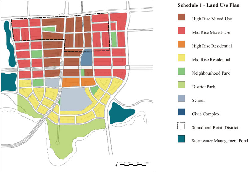
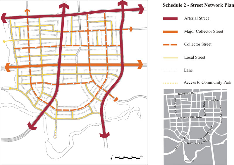
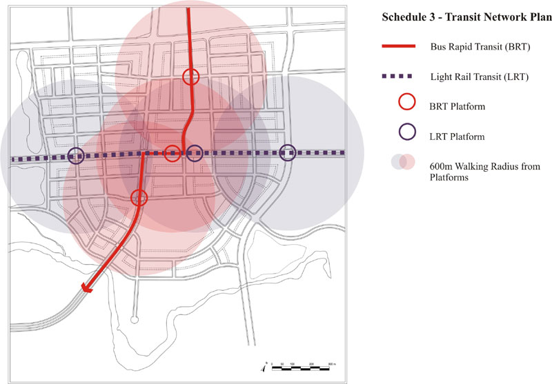
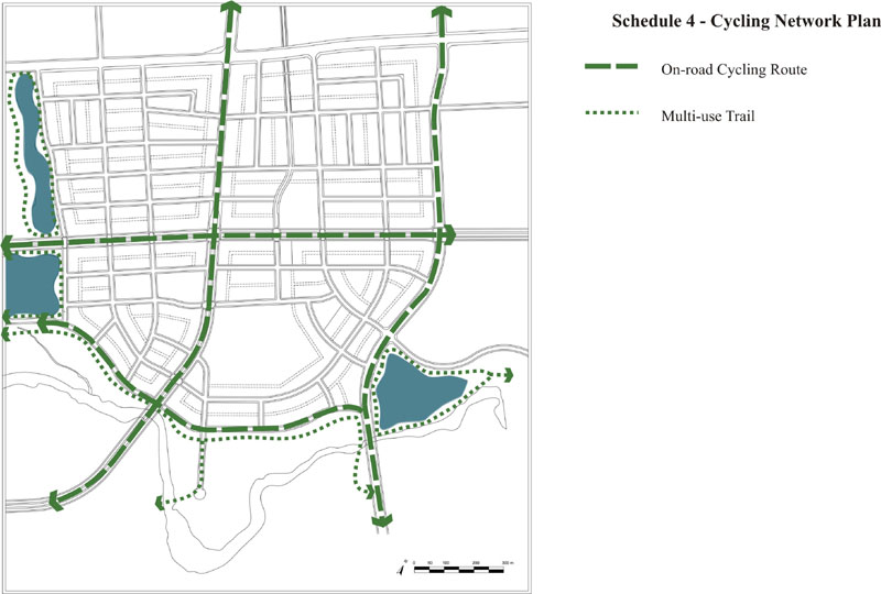
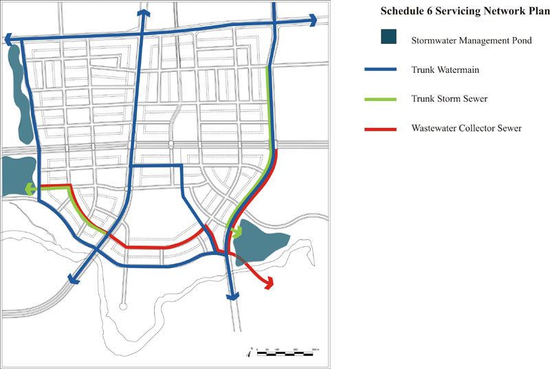