Design guideline PDF format
Approved by City Council on May 24, 2006.
Glossary
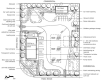
The following figure illustrates many of the elements discussed in the guidelines and defined in the glossary. It is for illustrative purposes only since the specific site context and characteristics will determine the relationships among these elements for an actual site.
Amenity: something that contributes to an area's needs, whether social, environmental or cultural
Built form: buildings and structures
Character: the unique identity of a place
Compatible / Compatibility: when the density, form, bulk, height, setbacks, and/or materials of buildings are able to co-exist with their surrounding
Driveway: a private way across land used for vehicular access from a public street - includes a private right-of-way
Façade: the principal face of a building (also referred to as the front wall)
Front yard: the space between the property line and the building facing the public street
Gas bar: place that sells automotive fuel along with small amounts of other automotive-related products such as pre-packaged motor oil or wind-shield washer fluid
Hard landscape: landscape features other than plant materials (e.g. decorative pavers, planter boxes, walks, fences, retaining walls, etc.)
Impervious surface: surface of land where water cannot infiltrate back into the ground (e.g. roofs, driveways, streets and parking lots)
Landscape buffer: a landscape area located along the perimeter of a lot intended to separate land uses either from one another or from a public street
Lane: a narrow street at the back of buildings, generally used for service and parking
Parking lot: a lot or other place used for the temporary parking of four or more passenger vehicles
Pedestrian walkway: sidewalk on private property
Permeable surface: a surface formed of material that allows infiltration of water to the sub-base
Property line: the legal boundary of a property
Public realm: the streets, lanes, parks and open spaces that are free and available to anyone to use
Right-of-way: a public or private area that allows for passage of people or goods, including, but not limited to, freeways, streets, bicycle paths, alleys, trails and walkways
Scale: the size of a building or an architectural feature in relation to its surroundings and to the size of a person
Screening: vegetation, landforms or structures that serve to reduce the impact of development on nearby properties
Setback: the required distance from a road, property line, or another structure, within which no building can be located
Sidewalk: unobstructed concrete or paved area for pedestrian travel in the public right-of-way
Stacking lane: an on-site queuing lane for motorized vehicles, which is separated from other vehicular traffic and pedestrian circulation by barriers, markings or signs
Streetscape: the overall character and appearance of a street formed by buildings and landscape features that frame the public street. Includes building facades, street trees and plants, lighting, street furniture, paving, etc.
Urban design: the analysis and design of the city's physical form
Figure Credits
| Figures | Description |
|---|---|
| Figure 1: | North Carolina, USA. The Conservation Fund |
| Figure 2: | South Carolina, USA. The Conservation Fund |
| Figure 3: | New Jersey, USA. www.agilitynut.com(link is external) |
| Figure 4,5,6,9,10,11,12,13,14,16,17,19: | Ottawa, Ontario. City of Ottawa |
| Figure 7,8,20: | Markham, Ontario. Bousefield Inc. |
| Figure 15: | Montreal, Quebec. City of Ottawa |
| Figure 18: | Unknown. US Environmental Protection Agency. |
| Figure 21: | Unknown. Ir Grootveld Architects. |