Overview
This document is the Council approved guide to the long-term growth and development of the Carp Road Corridor. The Community Design Plan provides guidelines for the day-to-day decision-making on land use planning and sets out the community's priorities for the future.
This Plan was adopted by Council in June 2004.
Background
1.1 Introduction
Ottawa City Council has recognized the need for a plan to support the Carp Road Corridor as a rural employment area and has made the completion of a Community Design Plan for the Corridor a priority. The Ottawa Official Plan adopted in May 2003 contains the following policy:
"The Village of Carp and the Carp Road Corridor will be the subject of individual Community Design exercises, both of which are to be completed by the end of 2003. The results of these exercises will be used to determined the boundaries of the Rural Employment Area and the policies associated with it and the detailed land use designations for each of the areas that will be incorporated by separate amendments into the Official Plan."

The rural employment area has been identified through the community design plan process and an Amendment designates the "Carp Road Corridor Rural Employment Area" on Schedule A of the Ottawa Official Plan to protect the area for future employment use.
This Community Design Plan is Council's plan of action for the Carp Road Corridor. It sets out land use policies for the Corridor, as well as strategies for servicing, the environment, road improvements, visual appearance and marketing of the rural employment area. It provides a framework to guide future development and addresses issues that have been identified as concerns in the community.
1.2 What is the Carp Road Corridor?
Carp Road extends from Stittsville to Fitzroy Harbour. The Carp Road Corridor is a significant rural employment area located in southern section of the Carp Road between Carp and Stittsville. It extends from Rothbourne Road in the south to March Road in the north. Within this nine-kilometre corridor there are 177 businesses employing more than 2500 people. It is the area where the former Township of West Carleton's industrial development is concentrated.
In addition to the industrial development, the Carp Road Corridor is home to 600 people (220 dwelling units) with country lot residential subdivisions, a golf course, three cemeteries, a church, as well as commercial and agricultural uses.
![[ Map ]](/sites/default/files/migrated/files/con022817_123467020.jpg)
1.3 The Vision for the Carp Road Corridor
While the Carp Road Corridor is an important employment area there are also a number of other uses. In addition to farms, churches, cemeteries and individual homes, there has been development for country lot subdivisions, a golf course, and numerous commercial uses. At the workshops held during the preparation of this plan, participants were asked to provide their vision for the corridor in the future. The participants indicated that the Carp Road Corridor should be recognized as:
- an employment area which is an attractive base for a wide range of industrial and commercial uses;
- a business area that has excellent access to Highway 417 and Carp Airport;
- a rural landscape; and
- an area where people work, live and play and enjoy a rural lifestyle.
A summary of the public consultation is attached as Appendix 1.
1.4 Objectives for the Carp Road Corridor
The objectives for the Carp Road Corridor were developed with the community using a collaborative community building approach. Two workshops were held with members of the community to discuss the future of the Corridor. The focus group representing different interests in the corridor (residents, landowners, tenants, businesses, developers, farmers) provided a vision for the Corridor. The objectives were based on the input received at the workshops.
Objectives
- To promote the Carp Road Corridor as a rural employment area which is an attractive base for a wide range of industrial and commercial uses;
- To enhance the visual appearance of the corridor and maintain the rural landscape;
- To provide a plan that ensures that future land uses are compatible and the Corridor continues to be an area where people work, live and play and enjoy a rural lifestyle;
- To ensure that servicing in the corridor is adequate and meets the needs for the future;
- To ensure that Carp Road continues to function as a major arterial road that provides easy accessibility to Highway 417 and the Carp Airport and businesses in the Corridor; and
- To protect and enhance natural features.
1.5 How to Achieve the Vision
This Community Design Plan (CDP) is an action plan that contains the strategies to achieve the objectives that have been articulated by the community for the Carp Road Corridor. It details actions required to turn objectives and values into achievable results. The Plan also recognizes that the City does not have the resources or expertise to implement all recommendations in this Plan. The success of the plan will depend on partnerships with others. For example, groups/organizations such as the West Ottawa Economic Development Association (WOEDA) will play a key role in promoting the Corridor as a rural employment area.
A Community Design Plan is different from a traditional Official Plan or Secondary Plan in that it provides a comprehensive set of measures and actions to direct growth in the future. In addition to policies concerning future land use that one would find in a traditional Official Plan, the Community Design Plan contains a complete strategy regarding future development of the Corridor. This plan has the following components:
- Background
- Land Use
- Environmental Protection
- Servicing
- Road Improvements
- Marketing
- Visual Appearance
- Land Use Compatibility
- Implementation
Land Use
Objective
Promote the Carp Road Corridor as a rural employment area which is an attractive base for a wide range of industrial and commercial uses.
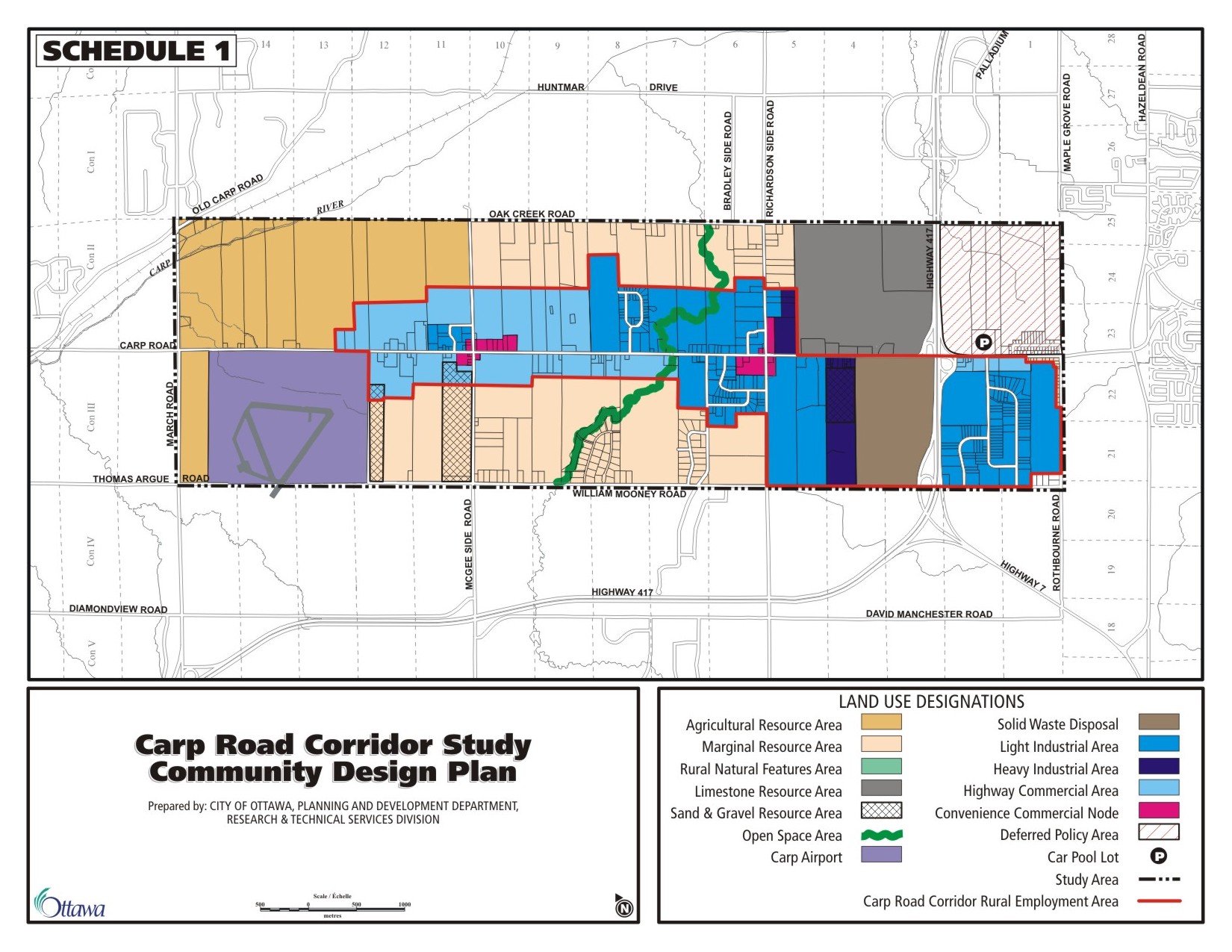
2.1 Land Use Designations
At the workshops, the focus groups indicated that development should proceed according to the following principles:
- properties fronting on the Carp Road are the most appropriate for highway commercial and industrial use;
- properties fronting on William Mooney and Old Oak Creek Roads are more appropriate for residential uses and other non-commercial/industrial uses;
- the area adjacent to the quarry and the landfill site (north of Highway 417) is viewed as an area for heavy industrial uses; and
- there should be a gradual intensification of uses - highway commercial - light industrial- heavy industrial from north (Carp Airport) to south (Highway 417).
These principles were used to identify the rural employment area that is designated by an Amendment to the Ottawa Official Plan. The Amendment changes the land use designation of the rural industrial part of the Corridor from "General Rural Area" to "Carp Road Corridor Rural Employment Area" as shown on Map 1 of the Appendix. The purpose of this designation is to identify the rural employment boundaries and provide policies for its future development and promotion as a rural employment area.
This Community Design Plan provides more detailed policies for the orderly and planned development of the Carp Road Corridor in achieve the community's vision for the Corridor. The Community Design Plan will be used to provide direction to the zoning by-law regarding appropriate uses in the corridor.
An Amendment to the Official Plan creates a new designation for the employment lands in the corridor "Carp Road Corridor Rural Employment Area". The Community Design Plan provides more detailed land use categories for the lands designated "Carp Road Corridor Rural Employment Area" and "General Rural Area" in the Official Plan. These sub-categories provide guidance as to the types of development that should occur in the future within the "Carp Road Corridor".
- Light Industrial
- Heavy Industrial
- Highway Commercial
- Convenience Commercial Node
- Marginal Resource
- Open Space
Other designations in the corridor study area include those listed below. The designations and their associated policies currently exist in the Ottawa Official Plan and are included in this plan only to provide a complete picture of how the area will develop in the future.
- Carp Airport
- Agricultural Resource Area
- Solid Waste Disposal Site
- Limestone Resource Area
- Sand and Gravel Resource Area
- Rural Natural Feature
2.2 General Policies
This plan provides direction to the zoning by-law for the future development of the lands within the Carp Road Corridor. The transition will occur over time and until the lands are developed for the intended use, the use of these lands will be restricted to existing uses or a limited range of agricultural uses.
Policy
- Until such time as the lands are developed for the intended use, the use of these lands shall be restricted to their existing use or a limited range of agricultural uses as provided for in Section 3.7.3 of the Ottawa Official Plan.
2.3 Light Industrial

There are five Industrial/Business Parks located within the Corridor. In addition, there is a sixth industrial subdivision that has been draft approved. A report prepared by Fotenn Consultants for the former Township of West Carleton in 2000 found that there is a significant amount of vacant industrial land within the Industrial/Business Parks. The approach recommended in this plan is to concentrate industrial development within the Industrial/Business Parks and provide additional future expansion lands adjacent or in close proximity to the existing parks. The uses in these parks are light industrial in nature with construction, manufacturing, transportation and warehousing, professional, scientific, and technical services being the dominant groups.
Policies
- The uses permitted may include light manufacturing plants, distribution, recycling and assembly plants, warehouses, service and repair shops, research, design and testing facilities, storage uses, transportation depots, contractor or construction related uses, compatible public and institutional uses.
- The uses permitted should be appropriately located and well designed so as to minimize nuisance or interference with existing or proposed uses of adjoining lands. Measures such as landscaping screening, buffing shall be used to reduce the impact of industrial uses on adjacent properties.
- Development should take place by way of plan of subdivision in industrial parks.
2.4 Heavy Industrial

Heavy industrial uses by their nature include those that, generate noise, fumes, odours, vibration and are hazardous and obnoxious. The workshop participants identified the area adjacent to the solid waste disposal site, and the quarry north of Highway 417 as an area appropriate/compatible for heavy industrial uses.
Policies
- The uses permitted include heavy industrial uses involving the manufacturing of products from local primary materials, quarry, abattoirs, salvage yards, sawmills.
- The uses permitted should be appropriately located and well designed so as to minimize nuisance or interference with existing or proposed uses of adjoining lands. Measures such as landscaping, screening, and buffering will be used to reduce the impact of industrial uses on adjacent properties.
2.5 Highway Commercial

Highway commercial uses are generally oriented to attract and serve passing traffic and require direct access to arterial roads. Carp Road is an arterial road that provides easy access to Highway 417 and the Carp Airport. The lands fronting on Carp Road were identified at the workshops as being the most suited to highway commercial uses. Convenience commercial uses such as stores, restaurants, banks, gas stations will be directed to the Convenience Commercial Nodes.
Policies
- The types of highway commercial uses permitted will include those that require large parking areas, extensive displays, and buildings designed to capture the attention of the passing public. They also provide a level of goods and services that relate directly to the automobile trade. Examples of highway commercial uses are automotive service facilities, automobile sales and repair facilities, tourist accommodation and uses serving the surrounding rural population.
- Convenience commercial uses such as stores, restaurants, banks, gas bars will not be permitted.
2.6 Convenience Commercial Node

The Corridor is a place where more than 2500 people are employed and 600 people live. Convenience commercial nodes would serve as a means to reduce strip development and provide some focus for the area. Convenience commercial was identified at the workshop as something that is lacking in the corridor and it was felt that more facilities would improve the quality of life for the residents and employees in the Corridor.
These nodes are best located at major road intersections, which are conveniently located to serve local residents and employees as well as the traveling public. They have the potential to create a sense of place, different from the rest of the corridor if located in places that are special places or landmarks in the community. The church/cemeteries, Cheshire Cat and Kirkstone B & B were recognized by the workshop participants as special places or landmarks that are unique. Convenience commercial nodes can reinforce places as landmarks and places of interest in the community. In order to create a sense of place, draw to peoples' attention that they are entering an activity area and have cars slow down at these nodes, buildings should be oriented to the street.
Two convenience commercial nodes are recommended on the Carp Road at:
- McGee Side Road, which includes the church/cemetery and Kirkstone B & B as places of interest; and
- Richardson Side Road, which includes the Cheshire Cat Restaurant.
Policies
- Permitted uses include those that provide services to local residents and employees in the corridor as well as servicing the needs of the traveling public. Examples include convenience stores, professional offices, business offices, gas bars, banks, and restaurants.
- Buildings at Convenience Commercial Nodes will have narrow setbacks to encourage buildings to be closer to the road with parking at the side or rear of the building with a sidewalk, enhanced lighting and landscaping at the street
2.7 Marginal Resource Area

The Marginal Resource Area designation is different from the General Rural designation in that Industrial and Commercial Uses are not permitted uses. The area contains a mix of uses including residential, agricultural, recreation and forestry uses. Workshop participants indicated that industrial/commercial development is not appropriate for the properties that front on Oak Creek and William Mooney Roads.
Policies
- Permitted uses shall include agriculture, forestry, conservation/open space, institutional, recreation and country lot residential subdivisions (in accordance with Ottawa Official Plan Section 3.7.2).
- Industrial and commercial uses shall not be permitted.
2.8 Open Space
The land along Richardson Creek has been identified as an important natural feature in the corridor. The part of the Creek that goes through the Arbour Woods subdivision has been protected as an open space system/feature for the subdivision. A similar approach is being proposed for the country lot subdivision application to the south. The intent is to have this open space system continue along Huntley Creek through the rest of the Carp Road Corridor.
Policies
- The land adjacent to Huntley Creek is designated as Open Space.
- All subdivisions abutting Huntley Creek will provide open space along the shoreline to be used for passive or active recreational uses, while maintaining a natural shoreline where possible.
2.9 Carp Airport

The Carp Airport is designated in the Ottawa Official Plan. The uses permitted include aviation and uses associated with an airport. West Capital Developments has submitted a business plan to the City to own, manage and develop the Carp Airport. The business plan includes a proposal to improve and expand the existing infrastructure - including extending the runway, providing water and wastewater treatment for the project area, and adding additional roads. Specific areas for operation and development include:
- The Airport,
- An Aviation Business Park,
- A Residential Fly-In Community, and
- Public water and wastewater.
The business plan and development plan for the Carp Airport are a separate process and are not addressed in this plan.
Policies
- The policies for Carp Airport in the Ottawa Official Plan (Section 3.10.2) shall apply.
2.10 Agricultural Resource Area
The land at the northern section of the Corridor adjacent to the Carp Airport is currently designated Agricultural Resource Area in the Ottawa Official Plan. The land is currently being farmed and is predominantly Class 2 soils. The LEAR evaluation (the system the City uses to evaluate agricultural potential) indicates that the area has good potential for agriculture. As there is sufficient land for industrial uses, no change to the Agricultural Resource Area designation is recommended.
Policies
- The policies for Agricultural Resource Areas in the Ottawa Official Plan (Section 3.7.3) shall apply.
2.11 Solid Waste Disposal Site
Solid waste disposal sites play an important role in the community. The City relies on modern solid waste facilities to support the community's waste diversion and solid waste disposal needs. The landfill site operated by Canadian Waste is a major land use in the corridor. The site is designated Solid Waster Disposal Site in the Ottawa Official Plan. Any expansion of the existing site will require a zoning amendment and applications will be evaluated based on the requirements of the Official Plan and the Environmental Assessment Act. The landfill site is a constraint for development on nearby properties. The Ottawa Official Plan requires that development proposals within 500 metres of an active waste disposal site must demonstrate that the landfill will not impact on the proposed use and that there will be no adverse impacts from the proposed use on continuing landfill operations.
Policies
- The policies for Solid Waste Disposal Sites in the Ottawa Official Plan (Section 3.8) shall apply.
2.12 Limestone Resource Area

Aggregate resources are used to build or repair houses, schools, shopping centres, factories, roads, sewers and water pipes. They may be used in a relatively natural state for fill or as a road base or they may be processed into natural materials for the construction industry such as concrete, asphalt or brick. The Spratt Quarry is designated Limestone Resource area in the Ottawa Official Plan and is an important source of aggregates in the City. It is a non-renewable resource that is close to local markets. The quarry has a remaining life span of more than 50 years. The intent of the designation is to protect the non-renewable mineral aggregate resources.
Policies
- The policies for Limestone Resource Areas in the Ottawa Official Plan (Section 3.7.4) shall apply.
2.13 Sand and Gravel Resource Areas
There are licensed sand and gravel pits in the Corridor that are designated in the Ottawa Official Plan. They are nearing depletion and their rehabilitation and potential after use were identified at the workshops as something that needs to be addressed in this Plan. This plan addresses both the short-term and long-term use of these lands. The Sand and Gravel Resource Area is shown as an overlay on Schedule 1 and once the resource has been depleted and the license has been surrendered, the policies of the underlying designation will apply.
Policies
- The Sand and Gravel Resource Areas are designated as an overlay on Schedule 1 and the policies in the Ottawa Official Plan (Section 3.7.4) shall apply.
- Once the sand and gravel resource has been depleted and the license has been surrendered to the Ministry of Natural Resources, the policies of the underlying designation on Schedule 1 will apply.
2.14 Deferred Policy Area
The area south of Highway 417, east of Carp Road is designated Rural Natural Feature and General Rural Area in the Ottawa Official Plan. The owners of the property filed an appeal with respect to the land designations and the applicable policies in the Ottawa Official Plan. The owners want the lands to be designated Urban Area. They have requested that further consideration of these lands in the Community Design Plan be deferred until the Official Plan appeal process has been exhausted.
Policies
- Consideration of the appropriate designation of the lands in the Deferred Policy Area will be deferred until the Official Plan appeal process has been exhausted.
Environmental Protection
Objective
Protect and Enhance Natural Features in the Carp Road Corridor.
3.1 Carp River Watershed/Subwatershed Plan
Natural features are defined as the physically tangible elements of the environment, including, wetlands, forests, ravines, rivers and associated wildlife habitat areas along the edge of, or which support significant ecological functions within the natural feature. The Ottawa Official Plan (Section 4.7) sets out the development requirements for environmental protection.
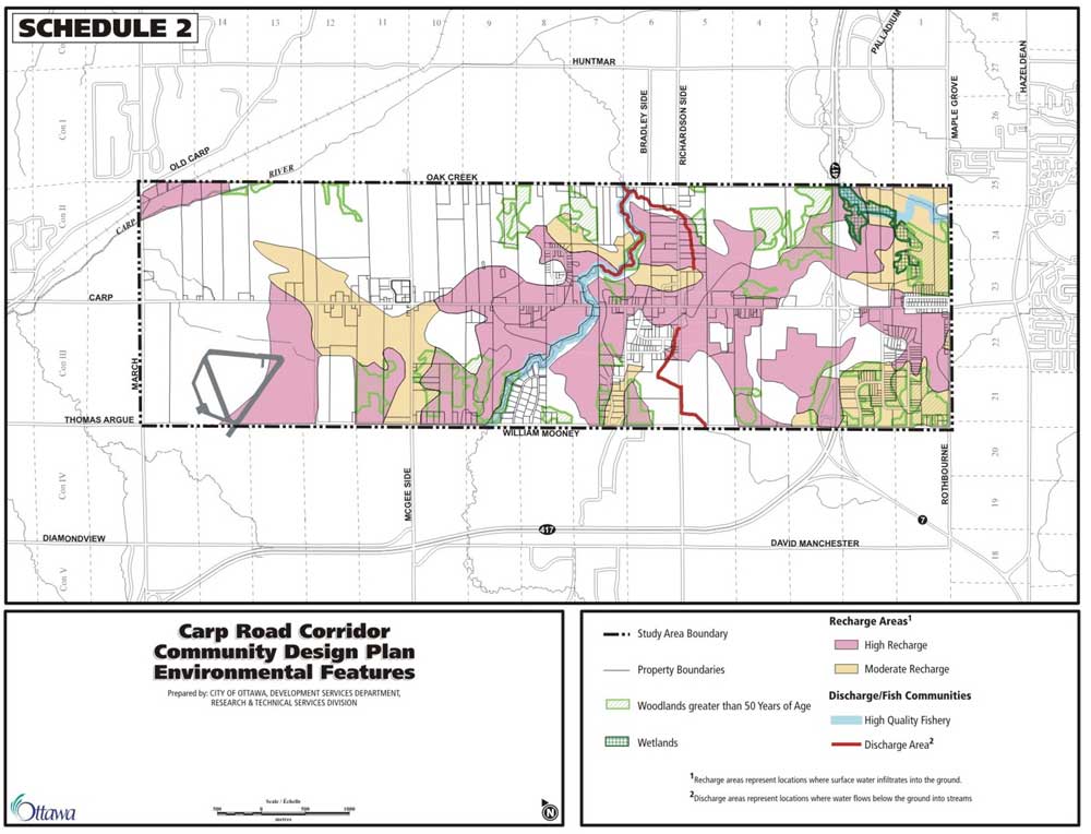
The Carp Road Corridor lies within the study area of the Carp River Watershed/Subwatershed Study. The purpose of the Study was to develop a comprehensive understanding of the Carp River watershed and, based on this, prepare a plan that would allow a healthy ecology to be maintained or strengthened while accommodating current land use and future development. Ottawa City Council will consider the Study for adoption in the spring of 2004. The Carp River Watershed/Subwatershed Study has identified the following environmental features within the corridor that require special attention:
- woodlands greater than 50 years of age,
- wetlands,
- groundwater recharge areas,
- groundwater discharge zones,
- river and tributary corridors, and
- aquatic communities.
These features are shown on Schedule 2.
The majority of tributaries are intermittent and only a few, including Huntley and Feedmill Creeks, are permanently flowing. The remainder of the flow comes from groundwater being directly discharged into the River. The tributary headwaters give rise to the best quality woodlands and areas of high biodiversity. The upper portions of Huntley Creek and Feedmill Creek are in good condition and can support cold water fish communities. Protecting natural features such as the wetlands, watercourses and woodlots contributes to preserving the rural landscape, which was identified at the workshops as something that should be maintained. Protection of the groundwater recharge areas will ensure long-term sustainable private services for the Corridor.
The objectives of the Carp River Watershed/Subwatershed Study specific to the Carp Road Corridor include:
- Conserving the hydrologic regime (surface water drainage to wetlands, ponds and watercourses as well as flows in the groundwater system) of the Carp River watershed for human use and maintaining healthy plant and animal communities.
- Protecting the quality of groundwater and surface water in wetlands, streams and the river to support healthy plant and animal communities.
- Providing for a healthy aquatic ecosystem, which supports cold water and warm water fish populations specifically in the Huntley and Feedmill Creek systems.
- Providing for healthy terrestrial (woodlands, wetlands and wildlife) ecosystem through protection and enhancement of valued natural features.
- Ensuring appropriate construction practices are used to protect the aquatic and terrestrial communities present in the Carp River Corridor.
- Ensuring that planning initiatives protect or improve the ecological integrity of both the Feedmill and Huntley Creek systems. Any development within the proximity of these systems should comply with recommendations put forth by the Carp River Watershed/Subwatershed Study to ensure the aquatic habitat, terrestrial features, water quality, and resident fish and benthic populations are maintained or improved.
Policies
- The environmental features identified in the Carp River Watershed/Subwatershed Plan are shown on Schedule 2.
- In reviewing development applications, the City will implement Section 4.7 of the Official Plan to protect the environmental features identified on Schedule 2.
- When reviewing development applications in areas identified as groundwater recharge areas, the City will consider the potential for impact on groundwater resources. A groundwater impact assessment may be required where the City has identified that the lands play a role in the management of the groundwater resource or the need is indicated in other available information such as subwatershed plans or local knowledge as per Section 4.7.5 of the Official Plan.
Servicing
Objective
Ensure that servicing in the corridor is adequate and meets the needs for the future.
4.1 Servicing Policies

The workshop participants saw the lack of municipal services as a threat/weakness in the corridor and it was mentioned most frequently as one of the reasons that businesses would choose not to locate in the corridor.
With the exception of the lands south of Highway 417 (the eastern half of the Westbrook Subdivision as well as properties on Lloydalex Crescent and Carp Road) the Carp Road Corridor is serviced by individual wells and septic systems. Connections to the area serviced by piped water (the public service area) are permitted for existing development/properties only and not new lots.
The Ottawa Official Plan states that development in the City's rural area will occur primarily on the basis of private individual services. The creation of new Public Service Areas (areas served by City-owned water and wastewater services) and the evaluation of servicing options by the City, are permitted in the rural area where identified in a Community Design Plan for a village, and where public health or environmental problems have been identified. The Carp Airport has also been identified in the Official Plan as a unique economic development situation where a public service area may be created. The Carp Road Corridor does not meet either of the criteria for the creation of a Public Service Area therefore, in accordance with the policies established in the Ottawa Official Plan, development in the corridor will be on the basis of private individual services. Protection of groundwater resources is necessary to ensure the continued safe operation of private individual systems in the corridor. In order to safeguard the integrity of groundwater ressources, it is important to ensure that new development can be accommodated within the system without affecting supplies available to others.
At the workshops the need for municipal services (piped sewer and water or communal systems) was frequently mentioned. It was identified as the biggest weakness/threat in the corridor. However no data exists to assess if there is a problem or how significant it is. The City will undertake a study to assess water quality and quantity in the Corridor and analyze the results. This will provide the information necessary to assess the water quality/quantity issues in the corridor and identify any problems with private services.
Policies
- The City will undertake a study to determine water quality and quantity in the Corridor. The study will recommend mitigation measures for new development on private services.
- When reviewing development applications for land uses that may pose a high risk to the groundwater resource, or for uses that use large volumes of water or dispose of large volumes of liquid or solid waste, the City will consider the potential for impact on groundwater resources as per Section 4.7.5 of the Official Plan. A groundwater impact assessment may be required where the City has identified that the lands play a role in the management of the groundwater resource or the need is indicated in other available information such as subwatershed plans or local knowledge.
- New development will be on the basis of private individual services in accordance with Section 4.4.2 of the Ottawa Official Plan.
- In the public service area, where there is a piped water supply, the following conditions will apply:
- Connections to the piped water supply will be permitted for existing development only and not new lots
- The water supply is for human consumption and not for commercial or industrial processing
- Future water availability may be conditional on acceptable wastewater treatment
- All water services to the building must be metered.
Transportation
Objective
Ensure that Carp Road continues to function as a major arterial road that provides easy accessibility to Highway 417 and the Carp Airport and businesses in the Corridor.
5.1 Transportation Policies

Accessibility to Highway 417 was viewed as an important consideration to attract businesses to the Carp Road Corridor. Workshop participants also expressed the opinion that Carp Road needs to be upgraded (widened, turning lanes to deal with increased traffic - volume and as well as trucks) in the Corridor. West Capital Development's business plan for the Carp Airport includes a proposal for industrial and commercial development as well as a residential fly-in community. This development will generate additional traffic in the corridor. Turning lanes into major developments that generate a lot of traffic such as the solid waste disposal site, the quarry and business parks would improve traffic movement and safety on Carp Road.
The peak hour volume for the Carp Road in the area near the Highway 417 Interchange is projected to be at or near capacity in 2021. This combined with the mix of heavy truck traffic in the area would indicate that protection for four lanes is warranted. Currently the Right-of-Way (ROW) for Carp Road within the Carp Road Corridor study area (March Road to Rothbourne Road) is protected for 30 metres in the Official Plan. A wider ROW of 37.5 metres is required for the southern section of Carp Road, from the Stittsville Urban Boundary to Richardson Side Road, to provide for a future widening to four lanes.
Policies
- Road modifications, turning lanes and intersection improvements, where warranted, will be identified by Transportation Impact Studies required by the Official Plan during the review of subdivisions, rezoning applications and site plans where there may be impact on the transportation network in the surrounding area.
- Where operational deficiencies are identified Traffic Studies, on a site specific or corridor basis, may be conducted to identify the required improvements and a program their for implementation.
- Carp Road:
- From "Richardson Side Road" to the "Urban Area Limit" the ROW will be protected for "37.5" metres
- From "Richardson Side Road" to "March Road" the ROW will be protected for 30 metres.
5.2 Car Pool Lots
The City operates a carpool parking lot on Carp Road south of Highway 417. The lot is shown on Schedule 1. It offers a location for carpool participants to meet and consolidate into one car, leaving other vehicles behind, thereby facilitating ridesharing by rural residents.
Policy
- The City will develop a Carpool Parking Lot Strategy that will identify supporting measures to effectively encourage its use as per Section 8.2 of the Transportation Master Plan.
Marketing
Objective
Promote the Corridor as a rural employment area which is an attractive base for a wide range of industrial and commercial uses.
6.1 Marketing the Carp Road Corridor Rural Employment Area
The Carp Road Corridor is an important rural employment area in the city. The location and diversity of this area creates an environment that allows for a many commercial, industrial and residential uses. Although those working and living along the corridor are aware of the opportunity and synergy found throughout the Carp Road, more could be done to market the Carp Road Corridor as a rural employment area. Despite the fact that there are 177 businesses employing 2500 people in the Corridor, the Corridor lacks the visibility it deserves as a rural employment area.

In the workshops that were held during the development of this community design plan; participants felt that there were several ways to market the Carp Road Corridor. Of these ideas, creating a visually pleasing corridor was the best and most effective way to market the corridor. Section 7 below provides an approach to develop a more visually pleasing corridor. Other main factors identified that would assist in the marketing efforts for the corridor included accessibility to Highway 417 and the Carp Airport, the corridors proximity to the urban area, as well as the availability and the relative affordability of larger parcels of land. With respect to who were identified as being the champions of the marketing effort, the West Ottawa Economic Development Association (WOEDA) as well as real estate agents/brokers were seen as being responsible for directly marketing the corridor. What is needed is a local champion such as WOEDA to carry to the marketing and promotion of the Carp Road Corridor Rural Employment Area.
Action Plan
- Identify a local champion (organization) who can effectively and willingly carry out the marketing and promotional functions of the corridor
- The initial steps for these efforts should be undertaken by WOEDA.
- Ultimately, this champion can take the form of either an informal organization (i.e. WOEDA) or a more structured and formal body such as a Business Improvement Area (BIA).
- Develop a Marketing Vision for the Carp Road Corridor
- The current stakeholders need to identify what types of businesses they want to attract in the future (i.e. maintain diversity or focus on specialization, focus on specific industries, completely change the current characteristics of the corridor etc.).
- Once a marketing vision has been established, set achievable and timely objectives (milestones) to gauge the success or the ability of the champion to achieve the vision.
- Develop a marketing Strategy for the Carp Road Corridor
- After completing (at a minimum) 1 & 2 above, WOEDA, or the identified champion needs to work with a marketing professional to develop a proper marketing strategy and implementation plan to effectively promote and market the corridor.
- The purpose of the Strategy is to incorporate the all-marketable assets into a framework that will allow for the Carp Road Corridor to be effectively marketed and promoted in an effort to realize the vision for the corridor.
Visual Appearance
Objective
Enhance the visual appearance of the corridor and maintain the rural landscape.
7.1 Why Visual Appearance is Important
Creating a visually pleasing corridor was seen by the workshop participants as the best way to market the Corridor. The poor appearance of the corridor was identified as one of the main reasons why a business would choose not to locate in the Corridor. The rural landscape and the rural environment were seen as positive aspects of the Corridor. Carp Road, due to its accessibility, is an attractive location for highway commercial and industrial development. The challenge is to accommodate these uses and maintain an attractive environment.
7.2 Improving the Existing Situation
There are a number of actions that can be carried out to improve the appearance of the corridor. To implement these measures, the landowners in the corridor will need to get together, either coordinated through an organization such as WOEDA or by creating a BIA for Carp Road, to undertake measures to improve the visual appearance of Carp Road.

Adding more trees and landscaping was the action most frequently suggested at the workshop to improve the visual appearance of the Corridor. The rural appearance/atmosphere was identified at the workshop as being an important image for the Corridor. Roadside planting is an opportunity to enhance the area's rural atmosphere through an informal mix of trees and shrubs. Fingers of the countryside should follow along the open space corridor and along designated entry roads/features to enhance the corridor's rural atmosphere.
The entrances to the Industrial/Business Parks should be designed to convey them as defined or special places. This would help to make them more attractive to businesses looking for prestige locations. In addition, a highly visible entrance makes the park easier to find for customers and/or service vehicles. Coordinated and attractive signage, clearly visible from Carp Road, would further enhance the parks.
The following measures are encouraged to improve the appearance of Carp Road:
- Plant a continuous row of trees along the corridor to visually enhance the rural character. Tree planting should consist of large-growing trees. These trees will reinforce the course and width of the road, give a living vertical emphasis and soften the form of the buildings. The row of trees located out-side the road right-of-way (3-6 m) will provide the greatest assurance that the trees will grow to maturity without disruption by utility construction and maintenance. This will allow the landowners to work together and implement the plantings with each site development as they proceed.
- Berm or provide green landscape edges to hide more unsightly uses within the Corridor.
- At the entrance to the corridor, Highway 417 in the south, and March Road in the north erect a physical entry feature or 'gateway', to announce the area with a design theme that could extend into a family of signage throughout the area.
- Erect entrance features to the Industrial/Business Parks with a design theme common to the Carp Road Corridor - highlighting the majority of the Park's occupants.
- Create special street lighting and other architectural features to enhance the appearance of the parks.
- Erect low, farmstead-type laid stone walls intermittently along the roadside as an identifiable signature of the Carp Road Corridor.
7.3 Design Guidelines
One of the weaknesses identified at the workshops was the lack of design consistency/balance in the Corridor. Design guidelines are a tool that can be used to provide guidance as to how new development can be made to be compatible with the residents' vision for the surrounding area. The recommendations above address measures that can be undertaken to improve the existing situation. New development applications (site plans and subdivisions) provide opportunities both to improve the existing situation (redevelopment) and ensure that new development is designed in a way that is visually pleasing.
Carp Road has a number of distinct land use types that warrant different measures/guidelines regarding visual appearance. The following expands on this idea.
Industrial/Business Park/ Subdivisions
Creating attractive industrial/business parks is important to attract new businesses to locate in the corridor. Relocating parking and storage from the front yards of buildings, providing landscaping and screening are measures that can create a visually pleasing environment. Industrial development will occur primarily in industrial/business parks or in limited cases on individual sites.
The following measures should be encouraged to improve the industrial areas:
- Limit access to Carp Road. Internal roads to the subdivision should provide access to Carp Road.
- Locate parking at the rear or side of buildings. Where this is not possible and parking is required at the front or side of the building a greater setback from the property line should be required to permit planting to mitigate the effects of the parking area (e.g. parking screened from view).
- Locate storage and service areas at the rear of buildings except on sites where the property backs onto Carp Road or the main entry road.
- Site buildings fronting on Carp Road to face, front and feature the road corridor (entry roads and all local roads).
- Preserve as many trees as possible on the site.
- Compensate for removal of existing trees by extensive planting in the open space corridor, entry features "gateways" and on-site landscape areas.
- Plant trees along the corridor - an informal mix of trees and shrubs is preferable, with more coniferous than deciduous species.
- Provide landscaping at the front of buildings.
- Use landscaping, decorative fences to screen unsightly uses.
- Create entry feature ("gateways") for new subdivisions/parks. This should include a sign and landscaping with the name of the development and the park occupants and enhanced lighting for visibility at night.
- Provide for turning lanes where warranted.
Highway Commercial

Because of their nature highway commercial uses require direct access to Carp Road. The appearance of these stand-alone businesses cumulatively impacts on how the corridor is perceived. Well-designed development is the key to preserving the visual appearance of the corridor.
The following measures should be encouraged to improve the appearance of Highway Commercial Areas:
- Locate storage, other than displays for highway commercial uses, at the rear of buildings.
- Locate parking at the rear or side of buildings. Where this is not possible and parking is required at the front or side of the building, a greater setback from the property line should be required to permit planting to mitigate the effects of the parking area (e.g. parking screened from view).
- Site buildings fronting on Carp Road to face, front and feature the road corridor (entry roads and all local roads).
- Preserve and add as many trees as possible on the site with tree planting within wide setbacks.
- Use landscaping, decorative fences, trees and/or shrubs in front of fencing to screen unsightly uses.
- Encourage the use of shared entrances and signage off Carp Road wherever possible.
- Coordinate signage so that it is attractive and in keeping with the theme for the corridor to address consistency and ease of identification of businesses.
- Encourage low, farmstead-type laid stone walls intermittently along the roadside as an identifiable signature of the Carp Road corridor.
Convenience Commercial Nodes
Convenience Commercial Nodes have the potential to create a sense of place if located at special places or landmarks in the community. Convenience commercial nodes can reinforce places as landmarks and places of interest in the community. In order to create a sense of place and have cars slow down at these nodes, buildings should be oriented to the street to create the sense of a more pedestrian oriented animated place.
The following measures should be encouraged in Convenience Commercial Areas:
- Narrow setbacks to bring buildings close to the road allowance to frame the street;
- Provide sidewalks;
- Enhance lighting with pedestrian scale lighting along sidewalks and pedestrian amenity areas (entry plazas);
- Provide on street parking along Richardson Side Road and McGee Side Road;
- Encourage shared parking at the rear groups of properties;
- Consider canopies or other weather protection over entrances and the pedestrian zone;
- Encourage the height of buildings to be 2 to 3 stories; and
- Plant trees and provide landscaping.
Land Use Compatibility With Residences
Objective
Provide a plan that ensures that future land uses are compatible and the Corridor continues to be an area where people work, live and play and enjoy a rural lifestyle.
8.1 Guidelines to Ensure Compatibility

There are a number of residences in or adjacent to the "Carp Road Corridor Rural Employment Area". In order to make sure that new development is compatible with existing uses it is essential to ensure an appropriate transition between existing and future uses.
Where a residential use back directly onto future development lands it is important to ensure that future development does not adversely affect the use of the property. The following guidelines apply where this condition occurs:
Guidelines

- Locate all unsightly and noise-generating elements, such as service lanes, loading zones, dumpsters and outdoor storage, away from adjacent residential properties;
- Separate existing residential and institutional areas which back onto "Carp Road Corridor Rural Employment Area" with a landscaped buffer, located on development lands, designed to mitigate unsightly and noise-generating elements. Construction and maintenance of the landscaped buffer may be required as a condition of subdivision/site plan approval;
- The buffer should be formed by a 6m wide, 1.5 to 2 metres high aesthetic berm, predominantly planted with evergreen trees that retain their lower limbs with age. The planting should create a continuous and dense visual screen; and
- Where the noise generated by future uses is of concern, the setbacks from residential uses should be increased to allow for densely landscaped buffers.
Implementation
9.1 Implementation is the Key
Implementation is the key to any plan. Successful implementation of this Community Design Plan will depend upon whether:
- The assumptions underpinning the Plan continue to be valid;
- Policy priorities remain constant or undergo significant change;
- The policies contained in the Plan are being carried out;
- The policies being carried out are having the desired outcomes.
The City will monitor the performance of this plan to assess whether the actions proposed have been carried out and whether they have had the desired effect and report back to Council five years following the adoption of this plan.
9.2 Summary of Development Review Process
Land Use
Permitted use shall be consistent with the land use plan shown on Schedule 1.
A groundwater impact assessment may be required for development applications to support land uses that may pose a high risk to the groundwater resource, or uses that use large volumes of water or dispose of large volumes of liquid or solid waste, as per Section 4.7.5 of the Official Plan.
Environmental Protection
The environmental features shown on Schedule 2 shall be protected by implementing the polices in Section 4.7 of the Official Plan.
In areas identified as groundwater recharge areas shown on Schedule 2, a groundwater impact assessment may be required to support development applications to determine the potential for impact on groundwater resources.
Servicing
Servicing, outside of public service areas, will be on the basis of private individual services. A groundwater impact assessment may be required for development applications to support land uses that may pose a high risk to the groundwater resource, or uses that use large volumes of water or dispose of large volumes of liquid or solid waste, as per Section 4.7.5 of the Official Plan.
In the public service area, where there is a piped water supply, the water supply is for human consumption and not for commercial or industrial processing.
Transportation
Requirements for turning lanes, combined entrances, traffic signals etc. will be determined by Transportation Impact Studies required by the development review process.
Visual Appearance
Implement design guidelines in Section 7.3 when reviewing development applications.
Land Use Compatibility
Implement the land use compatibility guidelines in Section 8.1 when reviewing development applications.
9.3 Summary of Actions and Responsibilities
This Community Design Plan outlines the actions required to achieve objectives, assigns responsibility for who will carry out the actions and gives a timetable for when the actions can expect to be completed.
| Action | Responsibility | Timing |
|---|---|---|
| Land Use | ||
| Approve an Official Plan Amendment to designate the Rural Employment in the Ottawa Official Plan | Council | 2004 |
| Approve the Community Design Plan to provide direction to the zoning by-law for future uses | Council | 2004 |
| Adopt a zoning by-law amendment to implement the land use plan shown on Schedule 1. | Council | 2004 |
| Environmental Protection | ||
| Implement Section 4.7 of the Official Plan by protecting the features shown on Schedule 2 of this plan. | Planning and Development Department | 2004 |
| Servicing | ||
| Undertake as Study to Assess Water Quality/Quantity | Planning and Development Department | 2004 |
| Transportation | ||
| Policies for turning lanes | Transportation, Utilities and Public Works Department | 2004 |
| Marketing | ||
Identify a local champion (organization) who can effectively and willingly carry out the marketing and promotional functions of the corridor
|
West Ottawa Economic Development Association (WOEDA) | 2004 |
| Visual Appearance | ||
| Tree Planting and Landscaping Plan/Program | WOEDA or local champion | 2004 |
| Co-coordinated signage for entrance to Corridor and Industrial/Business Parks | WOEDA or local champion | 2004 |
| Create special street lighting and other architectural features to enhance the appearance of the parks | WOEDA or local champion | 2004 |
| Implement Site Plan Guidelines when reviewing site plan applications | Planning and Development Department | 2004 |
| Land Use Compatibility | ||
| Implement Land Use Compatibility Guidelines when reviewing site plan applications | Planning and Development Department | 2004 |
Appendix 1
Collaborative Process
Preparation of the Community Design Plan for the Carp Road Corridor was accomplished through a collaborative community building approach that emphasizes shared values and mutual obligation. The idea is to make decisions that respond appropriately to real issues and achieve community support through a bottom-up rather than a top-down approach. This philosophy has three components:
- collaboration - everyone works together to realize a common vision.
- community - residents, landowners, tenants, businesses, developers and institutions, as well as various levels of government.
- building - strengthening and improving
Two workshops were held with focus groups, representing a range of interests (business, landowners, farmers, residents) in the Corridor, to provide input to the plan. A "Profile of the Carp Road Corridor" was provided to all workshop participants so that the participants would have a common information base when discussing the future of the Corridor.
The following is a summary of the vision, ideas, strategies that were suggested at the workshops held on August 26 and October 21, 2003.
A) August 26 Workshop
At the first workshop, participants were asked to provide their vision for the corridor in the future. The participants indicated that the Carp Road Corridor should be recognized as:
- an employment area which is an attractive base for a wide range of industrial and commercial uses
- a business area that has excellent access to Highway 417 and Carp Airport
- a rural landscape
- an area where people work, live and play and enjoy a rural lifestyle
Participants were also asked to identify the Strengths, Weaknesses, Opportunities and Threats (SWOT) for the corridor. The top three points identified are listed below.
Strengths
- Easily Accessible: Carp Rd., Highway 417, and March Rd
- Carp Airport
- Attractive current base of industrial/commercial properties for future growth
Weaknesses
- No municipal services (sewer and water)
- Lack of design consistency/balance
- Landfill site
Opportunities
- Airport is asset and assumes development of corridor (cargo not passenger)
- Become self-sufficient: water/sewer (use state of the art technologies)
- Emphasis on opportunity for high tech with associated spin off. Foresees development and employment opportunities
Threats
- Lack of services (water, sewer, high speed internet)
- High cost of development fees. Forces development to look outside the corridor for development opportunities
- Lack of clear zoning policies (developers are unable to plan ahead for future development of specific properties)
B) October 21 Workshop
At the second workshop participants were asked to identify strategies to achieve their vision for the corridor and address what measures should be included in the plan to take advantage of the Strengths and Opportunities and overcome the Weakness and Threats in the Corridor. Participants were asked to fill out a workbook and answer a series of questions related to:
- Servicing the Corridor and Defining Land Use
- Marketing the Corridor's Rural Employment Opportunities
- Visual Appearance and Design.
Servicing
At the first workshop participants identified the lack of municipal services (sewer and water) as being a weakness/threat in the corridor. The Ottawa Official Plan states that development in the rural area will be on the basis of private individual services. Currently there is no detailed information to indicate that there are water quality and quantity problems within the corridor. The participants at the second workshop supported undertaking a study to determine water quality and quantity in the corridor (identify any potential problems) and they supported some of the measures suggested to protect the groundwater resource.
Land Use
Participants indicated that industrial and commercial uses should be directed to the Carp Road. The southern end at Highway 417 (the location of the quarry and the landfill site) is seen as a heavy industrial area with the northern end being anchored by the Carp Airport. The participants saw a gradual intensification of uses - highway commercial - light industrial- heavy industrial from north (Carp Airport) to south (Highway 417). The back half of the lots fronting on William Mooney and Old Oak Creek Roads were seen as best suited to residential uses (not industrial and commercial).
Marketing the Rural Employment Area
Participants identified accessibility (to Highway 417, the urban area and Carp Airport), rural area/lifestyle and availability/cost of land as being reasons for businesses to choose to locate in the corridor. The diversity of businesses currently located in the corridor was also seen as a strength. The lack of services, planning and traffic on Carp Road were seen as reason that businesses would not locate in the corridor. Creating a visually pleasing corridor and better marketing by WOEDA (West Ottawa Economic Development Association) and real estate brokers were believed to be the best ways to market the corridor.
Visual Appearance
Old buildings were identified as being special places/landmarks in the community that should be preserved and enhanced. Planting trees, landscaping and better organization of land uses were identified most frequently as the best ways improve the overall image of the corridor.
C) Community Meeting
A draft of the Carp Road Corridor Community Design Plan was made available (on the City of Ottawa web site and at the Client Services Centres. A flyer was sent to all landowners in the Corridor:
- advising that a draft of the Community Design Plan was available for review, and
- extending an invitation to attend a community meeting to discuss the Plan. The community meeting was held at the Irish Hill Golf Course on March 11, 2004.
Sixteen submissions with comments on the Community Design Plan were received from the public. People that provided comments were sent a response indicating how the issue/concern raised has been addressed in the revised Plan.