2.1 Land Use
Local Context
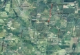
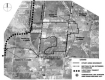
The Leitrim study area is located in the southwest portion of the former City of Gloucester. It is immediately adjacent to the National Capital Commission Greenbelt on its northern boundary with the southern boundary extending to the urban expansion boundary as defined by the City’s Official Plan. To the northwest is the Ottawa Macdonald -Cartier International Airport. Due to the airport’s proximity, Transport Canada’s Airport Operating Influence Zone (AOIZ) impinges on the northwest corner of the study area. To the east is Canadian Forces Station Leitrim operated by the Department of National Defence.
Leitrim Study Area.
Existing Land Uses
The study area is primarily undeveloped. The existing uses in the study area are comprised of a mix of uses including residential, institutional, industrial, and recreational. Existing residential uses include approximately 32 lots on Quinn Road west of Albion Road, 25 lots on Analdea east of Bank Street, and 5 lots on the south side of Leitrim Road. Near the centre of the study area west of Bank Street is Findlay Creek Village, a mixed density residential neighbourhood in its early phases of development. There are existing institutional uses located near the Bank and Leitrim Road intersection, including an Ottawa Police station, and Ottawa Hydro building, a fire station, a community centre, a church, and Leitrim Park, a district level park that contains Fred Barrett Arena and a number of fields and diamonds. To the south west of Leitrim Road and Bank Street is a Roman Catholic Cemetery. The northwest corner of the study area supports Industrial uses including the Albion and Del Zotto Industrial Parks.


Land Use Policy
Plan for Canada’s Capital, 1999
The Plan for Canada’s Capital classifies the study area as ‘Urban’ and ‘Environmental Protection’ on the National Capital Region: Concept 2050 plan. The urban area is intended to provide a rich symbolic setting for the seat of national government and a focus for expressing Canadian culture, history and values.
The study area is further partially classified as “Significant Physical Features: Hydrology and Geology” on the Environmental Synthesis Map. The Section, entitled Natural Heritage Areas, seeks to create a network of natural heritage areas that protects valued ecosystems which include, significant wetlands, forests and wildlife habitat. Relevant policy in support of this goal, and which might influence the design of the community, calls for the protection of valued ecosystems on federal lands and collaboration with other owners and organizations to integrate the management of conservation areas and to protect natural links beyond the federal government’s holdings.
Provincial Policy Statement, 2005
The Ontario Government has recently promulgated a new Provincial Policy Statement which provides direction for community design with efficient patterns of use, infrastructure and facilities designed in a manner that does not affect provincially significant wetlands and protects the diversity of natural features and the natural connections among them. A full range of housing and densities are to be provided, with a transportation system that is safe, environmentally sensitive and energy efficient.
City of Ottawa Official Plan, May 2003
Leitrim in one of the three designated developing communities outside of the Greenbelt. The Official Plan directs that Leitrim will accommodate 5500 households by 2021. The Leitrim community is designated General Urban Area, Employment Area and Major Open Space. A ‘Developing Community’ overlay designation also applies to a large part of Leitrim’s urban envelope.
The Plan includes policies to manage growth with the Urban Area which include an intent to promote compact, mixed use development by balancing housing and employment opportunities. A ratio of at least 1.3 jobs per household will be reflected in the amount of land designated for employment and residential development within each of the three urban communities outside of the Greenbelt.
Affordable housing will be required in accordance with applicable City policy in all new residential development and redevelopment in Leitrim. The Official Plan defines affordable housing as rental or ownership housing, for which a low or moderate income household pays no more than 30% of its gross annual income. The Official Plan directs that 25% of all new housing development and redevelopment is to be affordable to households at the 30th income percentile for rental and at the 40th income percentile for ownership.”
The Official Plan also includes specific targets for transportation including a modal split by 2021 of 10% for walking, 3% for cycling and 30% for public transit. In particular, Community Design Plans are to create environments that are favourable to cyclists and transit use.
In Developing Communities, the Official Plan sets targets of 2.0 hectares per 1,000 people for parks and leisure areas or 8-10% of developable land, and 4.0 hectares per 1,000 people for all greenspace or 16-20% of developable land, which includes all parks and leisure areas, environmental areas, and stormwater management ponds.
The Leitrim Community is located immediately adjacent to the Ottawa Airport. No noise sensitive uses will be permitted between the boundaries of the Ottawa Airport Operating Influence Zone and the 35NEP/NEF (the airport facility) except, redevelopment of existing residential or non-noise sensitive uses, infilling of residential uses and hotels and motels (subject to justification and detailed noise studies).
Gloucester Growth Area Recreation Master Plan
The Gloucester Growth Area Recreation Master Plan (1992) identified five cornerstones:
- Protect, preserve, acquire and maintain natural areas and features;
- Acquire riverfront where and when possible, consider the shorelines as natural parks and acquire appropriate water for water based activities;
- Establish a well defined and balanced three level park system; and,
- Provide appropriate links; and,
- Acquire good tableland with sufficient frontage, shape and size.
2.2 Environment
Leitrim Wetland
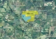
To the west and south of Leitrim is the Leitrim Wetland, a “fen” type of wetland that is approximately 330 hectares in size. It is rich in plant and animal life, containing a range of significant plant species and a variety of birds, mammals, fishes, amphibians, and insects. The Leitrim Wetland was evaluated as a Class 1, provincially significant wetland in October 1989. In 1991, a final wetland boundary for the Tartan lands was flagged in the field and agreed upon by Tartan, MNR and a naturalist group and was approved by the City of Gloucester and the RMOC in a 1992 Official Plan Amendment to the Gloucester Official Plan. The definition of the wetland boundary limit and buffer area on the Remer lands were established through an Ontario Municipal Board (OMB) decision in 1994. Both of these decisions established the permissible line of development within the Leitrim, and the division between the urban area and the provincially significant wetland is defined in the Official Plan.
‘Casino Wetland’
The ‘Casino Wetland’ is located adjacent to the southern boundary of the Leitrim, outside of the urban area. While the development limit for the Remer lands as determined by the OMB physically severs the ‘Casino Wetland’ from the main body of the Leitrim Wetland, it remains provincially significant given it meets the criteria for complexing. It is designated Significant Wetlands in the Official Plan. Environmental studies in support of development applications will have to have regard for the ‘Casino Wetland’s’ provincially significant status.
Other Wetlands
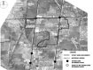
The work program for the Leitrim CDP included considering the potential complexing of other surrounding wetlands with the Leitrim Wetland. As part of this work, two unevaluated wetland areas were identified for consideration: the first located between Quinn Road and Del Zotto Avenue within the urban area of Leitrim (“Transport Canada Site”); the second located east of the
Rideau-Carleton Raceway and north of Rideau Road, outside of the urban area (“Raceway Wetland”). Jacques Whitford Environment Limited (JWL) was retained by the City to evaluate the potential for these wetland areas to be complexed with the Leitrim Wetland. This evaluation concluded that complexing the “Transport Canada Site” with the Leitrim Wetland is not recommended given that it appears to have little or no wetland features or functions that would warrant complexing. However, the property as a whole can be considered to represent a natural linkage area between the Leitrim
Wetland to the south, and forested/wetland areas to the north of Leitrim Road, and should be designated as such. The evaluation concluded that the “Raceway Wetland” has a number of wetland features and functions that could warrant complexing. A full evaluation applying the Ministry of Natural Resources Wetland Evaluation System will be carried out in 2005 by the City to confirm the wetland’s boundary and significance. This investigation has no implication on land within the Leitrim Community.
UNAEES Sites
The City is currently undertaking an Urban Natural Areas Environmental Evaluation Study (UNAEES) as part of the Greenspace Master Plan. The purpose of the UNAEES is to identify woodlands, wetlands and ravines throughout the urban area that are worthy of protection. The study will establish the relative environmental values of natural features, develop evaluation criteria, establish priorities for protection, and propose recommendations for management of urban natural features in consultation with the public. Four sites have been identified in the Leitrim Community as part of the UNAEES, all of which were unevaluated and are considered ‘candidate’ sites. “Site 105” is located on the west side of Albion Road between Del Zotto Road and Quinn Road (the Transport Canada Site” described in the above section). “Site 106” is located on the east side of Albion Road south of the Fenton Road industrial park “Site 107” is located immediately south of Leitrim Road, between Albion Road and Bank Street. “Site 108” is located adjacent to Bank Street, between Findlay Creek and the extension of Blais Road. Environmental impact statements for all four sites will be required as part of the development approval process.

2.3 Transportation
All the boundary roads (excluding the Earl Armstrong Road Extension) are currently two-lane rural arterial roads, with the exception of a short section of Bank Street south of Leitrim Road which is four lanes.
There are currently three significant intersections located on the study area’s primary roads. The Bank/Leitrim intersection at the community’s northeast corner carries the highest traffic volume and is traffic signal controlled. The Albion/Leitrim intersection at the northwest corner has historically been offset east and west of Albion Road with STOP sign control on the Leitrim approaches.
It was recently reconstructed to align, and traffic signal controlled. The Bank/ Findlay Creek intersection was also recently constructed to accommodate the traffic generated by the Findlay Creek Village development and is now traffic signal controlled.
There are a number of minor road intersections along the three bounding roads including Blais Road, Analdea Drive, Fenton Road, Quinn Road and Del Zotto Avenue. These are all STOP sign controlled on the side road approaches. The posted speed on all bounding roads is 80 km/h with a reduction to 60 km/h on the approaches to the Bank/Leitrim and Albion/Rideau Carleton Raceway signalized intersections.
The current southern terminus of the O-Train, the City’s light rail transit system, is at the Greenboro station, part of the South Keys commercial centre located approximately 4 kilometres to the north of Leitrim. The City is currently undertaking an Environmental Assessment of the North-South rail corridor for the O-Train extension, which will connect Leitrim at its western boundary, west of Albion Road. The Leitrim Community is currently serviced by one on-road, peak hour express bus route; the Transitway for buses currently ends at the Airport. On-road cyclists are currently not well accommodated on the bounding arterial roads. In most instances, shoulders are gravel, however, the adjacent section of Bank Street has paved shoulders as does the portion of Albion Road adjacent to the Rideau Carleton Raceway facility. Bicycle lanes and/or bicycle pockets are also provided at some of the adjacent signalized intersections.
With Bank Street being a provincial highway south of the City and with Albion Road extending south to Mitch Owens Drive, both serve as important commuter routes for those residents living in communities and rural estate developments located to the south of the Leitrim Community.
Community’s Transportation Planning History
There has been a significant amount of transportation planning work conducted over the years for the Leitrim Community and its component parcels. Generally, the purpose of these studies has been to identify the transportation network modifications required to accommodate the projected residential and/or employment growth in the Leitrim Community and in the combined Leitrim/ Riverside South Community. The identified modifications/ requirements included:
- Increasing the number of community road connections to the adjacent primary road network;
- Widening requirements on the internal and/or adjacent primary roadways;
- New roads or extensions;
- Widening requirements downstream of the communities on the major road approaching the central urban area of Ottawa; and,
- The rapid transit requirements for the Riverside South and Leitrim Communities.
With regard to the Leitrim Community, these transportation system requirements related to an identified development threshold of approximately 5300 residential units in the Leitrim Community. In addition to growth in the Leitrim Community, there has been other relatively recent projects or proposals in the area that have required transportation studies and that have or will impact on study area roads.
The City’s Official Plan and Transportation Master Plan
The Official Plan and Transportation Master Plan include the transportation related goals and objectives for the 20-year horizon (2021) as the City grows from approximately 800,000 people to 1.2 million people. With regard to the Leitrim Community, a 5300 residential unit threshold was accounted for in both Plans. This growth, along with the substantial growth in the Riverside South Community and in other sectors of Southeast Ottawa, resulted in the identification of a number of significant transit and road modifications throughout the southeast sector, including adjacent to the Leitrim Community. With these transportation network modifications, the current levels of population growth approved for the Leitrim Community, and for other growth areas in southeast Ottawa, can be adequately accommodated. The key, however, is that a significant increase in transit ridership is attained such that the City-wide peak hour transit ridership increases from the currently estimated 17% to the 30% level. It is because of this emphasis on increased non-auto travel that transit is the priority in the City’s Plans. It is very noteworthy, relative to the Leitrim Community, that the implementation of light rail transit from LeBreton Flats south to Leitrim Road and from the LeBreton Flats east to the Rideau Centre, is the City’s priority project in its rapid transit expansion program.
Also directly relative to the Leitrim Community and to the development of the Community Design Plan are the proposed modifications to the community’s adjacent arterial roads as per the Transportation Master Plan. Bank Street is planned to be widened to 4 lanes between 2013 and 2021. Albion Road is also planned to be widened to 4 lanes between 2013 and 2021 and Earl Armstrong Road is planned to be extended east from Albion Road to Bank Street as 2 lanes by 2008/09, depending on budget, priorities and needs.
2.4 Municipal Servicing
Stormwater
The Leitrim development area is a relatively flat site which slopes gently from west to east. The lands between Albion Road and Bank Street are ‘dished’ in a north-south direction that produces the Leitrim Wetlands in the centre of the study area. Storm drainage from the study area is currently provided through a series of ditches and municipal drains which outlet to Findlay Creek. Findlay Creek flows along the north boundary of the Leitrim Wetlands crossing Bank Street, meandering easterly across Blais Road, where it ultimately outlets to the Castor River and then the South Nation River. To support early development of this area, an interim stormwater management pond has been constructed outletting to Findlay Creek. This facility will be decommissioned upon construction of the permanent stormwater management facility.
Since 1989, both the former City of Gloucester and the new City of Ottawa have been working on a review of the needs and solutions for stormwater management measures needed to support development of the Leitrim community. In 1995 a report entitled “Leitrim Development Area Stormwater Management Environmental Study Report and Pre-Design” was completed by the City. That report outlined the stormwater design criteria needed to support future development in Leitrim. In particular, the report provided predesign details of a proposed stormwater management (SWM) pond to be located near the centre of the proposed residential area between Albion Road and Bank Street. Additional independent facilities were also recommended for other areas including lands west of Albion Road, east of Bank Street, the proposed industrial area and the Remer lands.
To date, this central SWM pond has successfully fulfilled the Provincial Class Environmental Assessment Process (Schedule C), including two unsuccessful bump up requests to the Province for individual EA’s. The central SWM pond has also received approval under the federal Canadian Environmental Assessment Act (CEAA process) and the federal government
(Department of Fisheries and Oceans) has finalized a fish compensation agreement with the City. Additionally, the proposed works have also received a Certificate of Approval from the provincial Ministry of Environment. Final design for the central SWM pond, which included the preparation and implementation of an Environmental Management Plan (EMP), identified sensitivities in the upper layer of the bedrock. As a result, to take advantage of the environmental and financial benefits associated with relocating the pond, the City chose to investigate alternative location options for the central facility.
Re-evaluation of the preferred location for the central SWM pond focused on areas to the east of the original pond location because the outlet for this facility is Findlay Creek, which flows easterly away from the Leitrim Wetlands. Two potential locations were revisited as candidates to relocate the core residential pond further away from the boundary of the Leitrim Wetlands. The first location was adjacent to Findlay Creek on the west side of Bank Street and the second location was adjacent to Findlay Creek just east of Bank Street.
Through the further investigation, the location west of Bank Street was not deemed a feasible location given that the bedrock was actually closer to the surface than the original location of the pond. The location east of Bank Street was identified as the preferred location for the SWM facility given its distance from the wetland boundary, that the bedrock drops off significantly east of Bank Street thus ensuring a substantial vertical separation between the bedrock and the bottom of the proposed SWM facility, and it is of a size that allows the consolidation of three of the four previous stormwater management ponds in the Leitrim Community.
The SWM facility is currently being redesigned in its revised location with construction expected in early 2005.
The proposed “consolidated SWM pond” is a development charge item which will be constructed and paid for by the developers through a “front ending agreement” with the City. The City will eventually reimburse the developers through development charges. The City is budgeting for the residential SWM facility in its current 5 year forecast.

Stormwater
Water Supply
Since 1989, the former City of Gloucester and the new City of Ottawa have been completing studies and analysis of the requirements for a potable water supply to the Leitrim Community. The City of Ottawa has subsequently constructed the necessary related external infrastructure. In 1991, the City of Gloucester completed a Pre-design Report that provided details of the external works needed to support development of the Leitrim Community.
In particular, the recommended works included a transmission pipeline from Hunt Club Road to Leitrim Road as well as a pumping station and storage reservoir. The pipeline, station and reservoir were constructed by the City between 1996 and 2002 along an existing CPR right-of-way and NCC property east of the Ottawa International Airport. Prior to 1991, there existed a local transmission network including the South Gloucester Pumping Station and watermain along Leitrim Road and Bank Street. Both the South Ottawa and South Gloucester Pumping Stations are intended to provide the necessary water supply to the Leitrim Community.
The existing water distribution and transmission network for the Leitrim Community consists of two pumping stations, the South Ottawa and South Gloucester stations, a short section of 600mm diameter transmission main between the South Ottawa Pumping Station and Leitrim Road and 400mm diameter distribution mains along Leitrim Road and Bank Street. There are also local watermains along existing streets in the area including Quinn Road, Del Zotto Avenue, Fenton Way and Analdea Road. This system is capable of providing both domestic water supply and fire fighting flows to the existing Leitrim Community.
Development is most likely to expand east to west from the Findlay Creek Drive/Bank Street intersection, a logical progression because most infrastructure, including wastewater disposal and stormwater management, is currently available at this location. At some point in development, temporary mains may be required to support phased development in this manner.
Existing Watermains
Sanitary Servicing
Following the Leitrim Community being brought into the urban development envelope, the former Regional Municipality of Ottawa-Carleton (RMOC) completed several studies and pre-design reports as prerequisites to development of a sanitary servicing collection and disposal system. The designated wastewater outlet for all sanitary flows from the Leitrim Community is the Conroy Road sewer which has been determined to have a capacity of 400 litres/second to support development of the Leitrim community. In 1989, the RMOC completed a Master Sanitary Drainage Report for the Leitrim Community and updated that report in 1992 to include an expanded urban area as determined by the Ontario Municipal Board. In 1995 the RMOC completed the Extension of the Conroy Road Sanitary Sewer and Pumping Station Pre-design report. The latter report included some modifications and updates to the 1992 report. In 1999, the RMOC completed the Leitrim Servicing Sanitary Sewer and Pump Station report which was an addendum to the 1995 report and provided final details of the sanitary servicing system for the Leitrim Community.
The important recommendations of the 1999 report included the proposed construction of a 380 litres/second pump station in the residential portion of the development area near Bank Street including twin forcemains from Bank Street to Leitrim Road and a gravity sewer from Leitrim Road to the Conroy Road Sanitary Sewer. In 2002, the City of Ottawa completed construction of the pumping station, one forcemain and a section of the gravity sewer so that development of the Leitrim Community could start. The balance of the total disposal system, including the second forcemain and extension of the gravity sewer to its final location, will be completed when needed to support future development. It is expected these final works will not be needed for several years.
The sanitary servicing system for the Leitrim Community includes the Leitrim Pump Station and a forcemain in Bank Street connected to the extended gravity sewer which presently terminates near the Bank Street/Conroy Road intersection. With the first phases of Findlay Creek Village, local sanitary sewers and trunk sewers have been constructed with the capacity to drain lands within the Leitrim Community but external to the “residential” area.
The major constraint to development of the Leitrim Community is the available wastewater capacity in the existing external sanitary collection and disposal system. That capacity has been identified as 400 l/s. Full development of the currently envisioned Leitrim Community is expected to generate about 400 litres/second.
The City has constructed the existing pump station and sewer/forcemain in Bank Street and Conroy Road as development charge items. There are no further development charge items included in the City’s current four year horizon for additional sanitary servicing improvements in Leitrim.