General Precinct Strategies

Streetscape Infrastructure Programme
Key general streetscape strategies to consider include:
- The precinct is subdivided by major east-west arterials as well as north-south parkways. These large roads fragment the traditional urban street grid, waste significant amounts of valuable canal-side property and restrict connections through the site to the north and east. The impact of these road systems needs to be mitigated.
- In the longer term, the City should consider removing or minimising the ramping system for Laurier and implementing traffic-calming measures, including safer pedestrian crossings between City Hall and Confederation Park.
- Queen Elizabeth Driveway north of Lisgar Street should be redesigned to allow the open space to take on a more direct waterfront relationship. The character of this road should be transformed from a parkway to a more gentle multi-use drive that winds through the park space, giving pedestrians priority over vehicles and increasing visual and physical access through to the Rideau Canal. New surface treatments will be required.
- Elgin Street between Laurier Avenue and Lisgar Street is very wide and not well defined as a park edge street. To better mesh with its Main Street function south of Lisgar, the northern portion of Elgin should be considered for a width reduction south of Laurier Avenue to match its existing width south of Lisgar.
- To function more as a neighbourhood street, Lisgar Street, as one of the key access routes to City Hall, should be made two-way east of Elgin Street.
Parks and Open Space Strategy
No additional park and open space is required within this precinct. However, a general improvement to the quality of spaces should be considered. The City should work in close partnership with both the NCC and Parks Canada to reinvigorate the open spaces of the Central Canal Area Precinct. Improvements should include:
- Creating a more distinctive network of public spaces around the existing institutional buildings, integrating City Hall's public gathering space with Confederation Park, introducing better access and animation to the canal edge and expanding the existing park space along the western edge of the precinct.
- Reducing the compartmentalization of the open spaces and enhancing public access across the vehicular corridors.
- Providing well distributed amenities to support special outdoor events and celebrations as well as to meet the needs of regular park users.
Built Form Guidelines
The character of the existing institutional uses located within the Confederation Park area should be protected. To preserve the amount of possible downtown open space, no major building development or expansion is recommended within the heart of this precinct. However, opportunities exist for commercial and residential infill along the south side of Lisgar Street and the west side of Elgin Street.
Along the western side of Elgin Street, some limited commercial development opportunities are present. New buildings located along this prestigious address should be of the best possible civic architectural quality. Buildings should front onto Elgin Street, integrate with the existing character of Elgin Street and overlook the park space beyond.
The southern edge of Lisgar Street offers more significant development opportunities, particularly for residential infill. At present, this edge contains a large number of surface car parks and underutilized parcels. It is important that new developments in this location respect the existing historic character of Lisgar Street and be compatible in scale and treatment.
Targeted Precinct Strategies
The Central Canal Area Precinct is a high-profile civic location appropriate for large gatherings, festivals, special buildings and special edge treatments. This precinct is an excellent candidate to expand the existing partnership between the NCC, Parks Canada and the City.
To help realize this function, seven initial targeted strategies have been outlined below. In some cases, additional studies within the context of a more detailed planning exercise, may need to be completed before some recommendations can be executed.
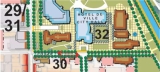
Targeted Precinct 29, 30, 31, and 32
29. Elgin Street Beautification
Functioning as both a Main Street at its southern end and a Ceremonial Route (Confederation Boulevard) at its northern tip, Elgin Street is a very important and unique street within the downtown core. As the street moves south from Wellington, its character and image transitions from the grandeur of its northern termination point to a more neighbourhood feel along its southern portion.
To reinforce the boulevard character of Elgin Street, the street would benefit from a co-ordinated programme of planting and landscaping, paving and street furniture. The quality of these improvements should match those of Confederation Boulevard. The City may wish to work with the NCC to use its street furniture designs along the southern section.
While the sides of the street were dealt with in the creation of Confederation Boulevard, the existing traffic islands and medians require significant improvements. The poor quality of this central feature and the great confusion of signage and traffic control measures are reducing the impact of the existing public realm investment in the area. Hardy street trees should be planted in each of the medians and boulevards, and higher quality finishes, such as granite, introduced. Street tree planting will help in the transition from the green spaces of the Canal Area Precinct to the harder urban forms of the Business Precinct. To allow for the expansion of the open space south of Laurier, it is recommended that the traffic islands be removed.
30. Lisgar Street Beautification
Lisgar Street needs to be repaired and protected. It should be restored to a neighbourhood scale that accommodates street-related low to medium intensity infill development that is compatible with the heritage character along its southern edge and a better quality access to important civic institutions including City Hall, the Drill Hall and Lisgar Collegiate.
To improve the quality of the environment along Lisgar Street, the Strategy recommends the following:
- converting Lisgar Street to two-way
- reclaiming the City-owned right-of-way along its edges that are currently being used for surface parking on adjacent lands
- undertaking a major reinvestment in the streetscape and public realm of Lisgar Street and adjacent frontages to match it to the improvements on the City Hall site outlined below.
31. Open Space Expansion & Narrowing of Elgin Street
The strategy recommends narrowing Elgin Street between Lisgar Street and Laurier Avenue to allow for the expansion of the green space around the Human Rights Monument and Provincial Courts.
This width reduction will make Elgin Street more compatible with its Main Street function and create a more human scale as it transitions from the national ceremonial role to the civic precincts and established neighbourhoods.
The reduction will create an expanded greenspace in front of the historic part of City Hall and the Knox Church tower. Ensuring that the Lisgar/Elgin junction is attractive and visually captivating is important, as this site is the cornerstone of the City's main civic buildings and public functions. The Human Rights Monument would then be more central in this high profile location and the expanded greenspace would act as an entry room to Confederation Boulevard.
32. Heritage District Open Space Enhancement
Although the quality of some of the open spaces between Laurier Avenue and Lisgar Street are quite high, they are fragmented and fail to respond to many of the adjacent buildings. At present, the Canal edge south of the National Arts Centre is particularly weak. Although quite well used during periodic special events, the lack of significant year-round animation in the park spaces and along the Canal edges is a lost opportunity.
The unique cluster of heritage buildings situated in this location, including Lisgar Collegiate and the Drill Hall are lost amongst car parking and overgrown landscaping. These buildings fail to relate to the Canal and lack a meaningful front door. They make a wonderful architectural statement for the entrance to the downtown and potentially would be an ideal location for civic programming. Such a grand set of buildings in this idyllic location demand external spaces that are of a quality that matches their civic importance.
There is an opportunity for the City, within the context of a more detailed planning exercise, to undertake a comprehensive redevelopment plan of the open spaces bounded by Lisgar Street, Queen Elizabeth Driveway, Elgin Street and Laurier Avenue to bring it up to a significantly higher standard. Creating quality public gathering spaces that are inviting, safe and attractive is critical for ensuring that these spaces become well-used meeting and gathering areas. Public space improvements will help to reinforce the public functions of the civic buildings, accentuating their unique role and design. Recommended open space improvements in the heritage areas include:
- Disengage the primary commuter traffic route along Queen Elizabeth Driveway from the Mackenzie King Bridge south to Cooper Street to allow for the creation of a new Canal-front open space and the provision of a significantly enhanced setting for the heritage buildings. This will create a waterfront edge for Confederation Park.
- Reconnect Cooper to the Queen Elizabeth Parkway to offload traffic from the Canal Park Area.
- Establish Cooper as a two-way street east of Elgin.
- Restore the landscape parkway character of Queen Elizabeth Driveway between Mackenzie King Bridge and Somerset. The Driveway should be realigned to create additional open space fronting directly onto the Canal.
- Create a connected series of public squares and civic spaces between the historic buildings at the south end of the site.
- Re-landscape the site to accentuate the public realm improvements and better frame important heritage buildings.
- Introduce an expanded network of pedestrian paths through the site.
- Co-ordinate street furniture and lighting across the site.
- Introduce a programme of street tree planting along the Lisgar Street and Laurier Avenue edges.
- Ensure that buildings along the eastern edge are opened up to the Canal to reinforce this important edge.
33. Canal Edge Treatment
As one of Ottawa’s most important and well-recognised symbols, there is a need to turn the Rideau Canal from a visual amenity into a useful amenity: an historic urban park space. Due to the existing road structure and dominance of the Queen Elizabeth Driveway through the site, the Canal has been severed from its natural connection with Confederation Park and open space around City Hall. The canal is a wonderful and unique asset that needs to be fully exploited by the City.
Once the reconsideration of the alignment, form and function of the Queen Elizabeth Driveway has been undertaken, the Strategy recommends introducing a multilevel pedestrian priority promenade along both edges of the Canal between Wellington Street and the proposed pedestrian bridge at Somerset. The promenade will create a stronger edge for the canal and complement the recommended open space improvements.
More importantly, the promenade will give residents and visitors to the city much closer access to the water and make the Canal a more usable amenity. It is also important to recognize the entrances to downtown Ottawa from the Rideau Canal along the Lisgar corridor and the front of the City Hall complex. Important views to City Hall, the historic high school and the Armoury will be re-established from the Canal.
As a longer-term priority the City, in partnership with the NCC and Parks Canada, should explore opportunities for providing mooring bays along the Canal edges south of Laurier. This would help introduce additional activity to the Canal and park areas, enlivening both the water and the Canal edges.
34. Re-imaging and Integration of the Queen Elizabeth Driveway Arrival Sequence
Queen Elizabeth Driveway is part of the Capital Region's extensive system of parkways and driveways. Historically, this system was introduced to bring the natural and human environments into closer harmony and to create a pleasant downtown driving experience. Although still offering very picturesque views from the car - including some of the best views of the City - due to changing trends, Queen Elizabeth Driveway presently functions more as a commuter route to and from the downtown. In the absence of traffic signals to slow vehicles, with pedestrian and bicycle systems well removed from the road edge, and often unmarked lane configurations, cars tend to travel at a fast speed along the length of its route.
Consequently, when busy, the Driveway creates a physical separation to the Canal edge from the major park and other green spaces to the west. This is an inappropriate image for such a picturesque Canal-side route through the heart of the downtown.
To open access to the Rideau Canal and reduce the impact that the Queen Elizabeth Driveway has on adjacent open spaces, the Strategy recommends the following directions:
- Reconnect the Driveway more directly to the City's street grid at Cooper as an entry to downtown and make Cooper a two-way street east of Elgin.
- Return the Driveway to a parkway image and possibly narrow the travel width and mark the pavement with one lane in each direction.
- Reconsider some of the landscaping along the Driveway as it enters the downtown to provide stronger views of important civic buildings and create a more urban atmosphere.
Queen Elizabeth Driveway should be a very elegant eastern gateway route to the downtown that reminds people they are travelling through an active and vibrant urban area. These directions should be considered within the context of a more detailed planning exercise.
35. Central Park on the Canal Design Competition
The Central Canal Area Precinct contains one of Ottawa's most important civic gathering spaces and acts as a key seam between the Capital and Civic Realms. It houses major institutions, including City Hall, the Ontario Court House and the National Arts Centre. Consequently, it is critical that the quality of this space as both a civic and federal showcase is high.
To raise the quality of the open space experience from a fragmented and underutilized space for the city to a major destination park space for the Nation's Capital, the City in partnership with the NCC and Parks Canada, should undertake a design competition for enhancements to the public realm. This should be directed by the creation of a shared long-term vision for the area that includes:
- Improving the City Hall site and the adjacent historic properties as a major downtown open space.
- Improving the City Hall Parks and Confederation Park waterfront open spaces with access to the Canal.
- Emphasizing pedestrian circulation, avenue trees and amenities on the road network across the precinct.
- Distinguishing the edges of the Rideau Canal as a major urban historic park space.